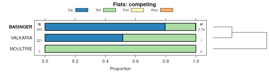
Official Series Description


Lab Data Summary

Aggregate lab data for the BASINGER soil series. This aggregation is based on all pedons with a current taxon name of BASINGER, and applied along 1-cm thick depth slices. Solid lines are the slice-wise median, bounded on either side by the interval defined by the slice-wise 5th and 95th percentiles. The median is the value that splits the data in half. Five percent of the data are less than the 5th percentile, and five percent of the data are greater than the 95th percentile. Values along the right hand side y-axis describe the proportion of pedon data that contribute to aggregate values at this depth. For example, a value of "90%" at 25cm means that 90% of the pedons correlated to BASINGER were used in the calculation. Source: KSSL snapshot . Methods used to assemble the KSSL snapshot used by SoilWeb / SDE

Click the image to view it full size.

Pedons used in the lab summary:

MLRALab IDPedon IDTaxonnameCINSSL / NASIS ReportsLink To SoilWeb GMap
154S27_0171975-FL053-S27_017Basinger3Primary | Supplementary | Taxonomy | Pedon | Water Retention | Correlation | Andic Soil Properties28.4553909,-82.6316833
15491P024490FL101001Basinger5Primary | Supplementary | Taxonomy | Pedon | Water Retention | Correlation | Andic Soil Properties28.3033333,-82.4950027
154S28_017S1985FL055017Basinger3Primary | Supplementary | Taxonomy | Pedon | Water Retention | Correlation | Andic Soil Properties27.6337452,-81.355751
155S49_0181974-FL097-S49_018Basinger3Primary | Supplementary | Taxonomy | Pedon | Water Retention | Correlation | Andic Soil Properties28.111742,-81.2381439
155S64_0291976-FL127-S64_029Basinger3Primary | Supplementary | Taxonomy | Pedon | Water Retention | Correlation | Andic Soil Properties28.9624329,-81.0378952
15540A5046S1953FL115009BASINGER4Primary | Supplementary | Taxonomy | Pedon | Water Retention | Correlation | Andic Soil Properties27.2661591,-82.4215317
15540A5047S1953FL115018BASINGER4Primary | Supplementary | Taxonomy | Pedon | Water Retention | Correlation | Andic Soil Properties27.2372723,-82.3526459
155S05_016S1967FL009016Basinger3Primary | Supplementary | Taxonomy | Pedon | Water Retention | Correlation | Andic Soil Properties28.4290867,-80.7916489
155S50_011S1973FL099011Basinger3Primary | Supplementary | Taxonomy | Pedon | Water Retention | Correlation | Andic Soil Properties26.789917,-80.0927124
155S50_022S1973FL099022Basinger3Primary | Supplementary | Taxonomy | Pedon | Water Retention | Correlation | Andic Soil Properties26.6945305,-80.0775528
155S14_006S1984FL027006Basinger3Primary | Supplementary | Taxonomy | Pedon | Water Retention | Correlation | Andic Soil Properties27.1596355,-81.6108093
156AS06_0101972-FL011-S06_010Basinger3Primary | Supplementary | Taxonomy | Pedon | Water Retention | Correlation | Andic Soil Properties26.0785999,-80.2518463

Water Balance

Monthly water balance estimated using a leaky-bucket style model for the BASINGER soil series. Monthly precipitation (PPT) and potential evapotranspiration (PET) have been estimated from the 50th percentile of gridded values (PRISM 1981-2010) overlapping with the extent of SSURGO map units containing each series as a major component. Monthly PET values were estimated using the method of Thornthwaite (1948). These (and other) climatic parameters are calculated with each SSURGO refresh and provided by the fetchOSD function of the soilDB package. Representative water storage values (“AWC” in the figures) were derived from SSURGO by taking the 50th percentile of profile-total water storage (sum[awc_r * horizon thickness]) for each soil series. Note that this representation of “water storage” is based on the average ability of most plants to extract soil water between 15 bar (“permanent wilting point”) and 1/3 bar (“field capacity”) matric potential. Soil moisture state can be roughly interpreted as “dry” when storage is depleted, “moist” when storage is between 0mm and AWC, and “wet” when there is a surplus. Clearly there are a lot of assumptions baked into this kind of monthly water balance. This is still a work in progress.

Click the image to view it full size.


Click the image to view it full size.

Sibling Summary

Siblings are those soil series that occur together in map units, in this case with the BASINGER series. Sketches are arranged according to their subgroup-level taxonomic structure. Source: SSURGO snapshot , parsed OSD records and snapshot of SC database .

Click the image to view it full size.

Select annual climate data summaries for the BASINGER series and siblings. Series are sorted according to hierarchical clustering of median values. Source: SSURGO map unit geometry and 1981-2010, 800m PRISM data .

Click the image to view it full size.

Geomorphic description summaries for the BASINGER series and siblings. Series are sorted according to hierarchical clustering of proportions and relative hydrologic position within an idealized landform (e.g. top to bottom). Most soil series (SSURGO components) are associated with a hillslope position and one or more landform-specific positions: hills, mountain slopes, terraces, and/or flats. Proportions can be interpreted as an aggregate representation of geomorphic membership. The values printed to the left (number of component records) and right (Shannon entropy) of stacked bars can be used to judge the reliability of trends. Small Shannon entropy values suggest relatively consistent geomorphic association, while larger values suggest lack thereof. Source: SSURGO component records .

Click the image to view it full size.

Click the image to view it full size.

There are insufficient data to create the 3D mountains figure.

Click the image to view it full size.

Click the image to view it full size.

Competing Series

Soil series competing with BASINGER share the same family level classification in Soil Taxonomy. Source: parsed OSD records and snapshot of the SC database .

Click the image to view it full size.

Select annual climate data summaries for the BASINGER series and competing. Series are sorted according to hierarchical clustering of median values. Source: SSURGO map unit geometry and 1981-2010, 800m PRISM data .

Click the image to view it full size.

Geomorphic description summaries for the BASINGER series and competing. Series are sorted according to hierarchical clustering of proportions and relative hydrologic position within an idealized landform (e.g. top to bottom). Proportions can be interpreted as an aggregate representation of geomorphic membership. Most soil series (SSURGO components) are associated with a hillslope position and one or more landform-specific positions: hills, mountain slopes, terraces, and/or flats. The values printed to the left (number of component records) and right (Shannon entropy) of stacked bars can be used to judge the reliability of trends. Shannon entropy values close to 0 represent soil series with relatively consistent geomorphic association, while values close to 1 suggest lack thereof. Source: SSURGO component records .

There are insufficient data to create the 2D hillslope position figure.

There are insufficient data to create the 3D hills figure.

There are insufficient data to create the 3D mountains figure.

Click the image to view it full size.

Click the image to view it full size.

Soil series sharing subgroup-level classification with BASINGER, arranged according to family differentiae. Hovering over a series name will print full classification and a small sketch from the OSD. Source: snapshot of SC database .

Block Diagrams

Click a link below to display the diagram. Note that these diagrams may be from multiple survey areas.

  1. FL-2012-04-25-30 | Polk County - October 1990

    Relationship of soils to topography (Soil Survey of Polk County, Florida; October 1990).

Map Units

Map units containing BASINGER as a major component. Limited to 250 records.

Map Unit Name Symbol Map Unit Area (ac) Map Unit Key National Map Unit Symbol Soil Survey Area Publication Date Map Scale
Basinger sand, 0 to 2 percent slopes71067114732932vbpcfl00919901:24000
Basinger sand, depressional6160914732921lg2kfl00919901:24000
Basinger fine sand, 0 to 2 percent slopes583103210832svymfl01719851:20000
Basinger fine sand, depressional, 0 to 1 percent slopes677943210942v16tfl01719851:20000
Basinger fine sand, 0 to 2 percent slopes31800013868972svymfl02719861:24000
Basinger fine sand, frequently ponded, 0 to 1 percent slopes5886013868992v16vfl02719861:24000
Basinger fine sand, frequently flooded4303013868981hk5nfl02719861:24000
Placid, Basinger, and St. Johns soils, depressional121650015294141nbgyfl03519911:15840
Basinger fine sand, 0 to 2 percent slopes145192014535732svymfl04319911:24000
Basinger fine sand, frequently ponded, 0 to 1 percent slopes34551014535872v16vfl04319911:24000
Basinger fine sand, 0 to 2 percent slopes71080013843862svymfl04919811:20000
Basinger fine sand, frequently ponded, 0 to 1 percent slopes37139013844152v16vfl04919811:20000
Basinger sand, 0 to 2 percent slopes174924011514172vbpcfl05119861:24000
Basinger fine sand, depressional, 0 to 1 percent slopes1044603220722v16tfl05319761:20000
Basinger fine sand, 0 to 2 percent slopes921863221272svymfl05319761:20000
Floridana-Basinger association, occasionally flooded24918322087bt4xfl05319761:20000
Basinger fine sand, 0 to 2 percent slopes126385614135122svymfl05519821:24000
Basinger, St. Johns, and Placid soils333566714135321jfwtfl05519821:24000
Basinger fine sand, frequently ponded, 0 to 1 percent slopes31637014135032v16vfl05519821:24000
Paola-Basinger sands, rolling45598514135441jfx6fl05519821:24000
Tavares-Basinger-Sanibel complex, rolling34454114135331jfwvfl05519821:24000
Satellite-Basinger-Urban land complex44426314135431jfx5fl05519821:24000
Anclote-Basinger fine sand, frequently flooded41289414135401jfx2fl05519821:24000
Basinger, Holopaw, and Samsula soils, depressional55627514069981j731fl05719861:20000
Placid and Basinger fine sands, depressional13584714215641jq7xfl08519791:20000
Basinger fine sand, 0 to 2 percent slopes55178014216022svymfl08519791:20000
Basinger fine sand, 0 to 2 percent slopes23351014161532svymfl09319981:24000
Basinger and Placid soils, depressional32601014161541jjmdfl09319981:24000
Basinger fine sand, frequently ponded, 0 to 1 percent slopes3332283231432v16vfl09519861:20000
Samsula-Hontoon-Basinger association, depressional4130158323156bv8dfl09519861:20000
Basinger fine sand, depressional, 0 to 1 percent slopes64719114838462v16tfl09719761:20000
Basinger fine sand, 0 to 2 percent slopes54463714838452svymfl09719761:20000
Basinger fine sand, depressional, 0 to 1 percent slopes23137803231922v16tfl10119801:20000
Basinger fine sand, 0 to 2 percent slopes2235703231912svymfl10119801:20000
Basinger fine sand-Urban land complex, 0 to 2 percent slopes6112031029792x9flfl10320031:24000
Basinger fine sand, frequently ponded, 0 to 1 percent slopes7102010171122v16vfl10320031:24000
Basinger fine sand, 0 to 2 percent slopes872260731030352y9hyfl10519871:20000
Basinger mucky fine sand, frequently ponded, 0 to 1 percent slopes362205231030342y9hlfl10519871:20000
Basinger sand, 0 to 2 percent slopes8806814211652vbpcfl11119901:24000
Basinger, Samsula, and Hontoon soils, depressional102289614786941lmptfl11719861:20000
Basinger and Smyrna fine sands, depressional11812414786951lmpvfl11719861:20000
Nittaw, Okeelanta, and Basinger soils, frequently flooded23789114787071lmq7fl11719861:20000
Basinger and Delray fine sands9543314786931lmpsfl11719861:20000
Floridana-Basinger association, frequently flooded633899323673bvt2fl11919851:24000
Basinger fine sand, depressional, 0 to 1 percent slopes4329133236512v16tfl11919851:24000
Basinger fine sand, 0 to 2 percent slopes244473236312svymfl11919851:24000
Basinger fine sand, frequently ponded, 0 to 1 percent slopes8900515441862v16vfl12719771:20000
Basinger fine sand, 0 to 2 percent slopes4308613898692svymfl60619811:20000
Basinger sandBa1863640576phkrfl60919681:24000
Basinger fine sand, 0 to 2 percent slopes62337014072682svymfl61119941:20000
Basinger and Myakka sands, depressional81283014072701j7ctfl61119941:20000
Basinger fine sand-Urban land complex, 0 to 2 percent slopes7333031029802x9flfl61119941:20000
Basinger fine sand, 0 to 2 percent slopes171441014134662svymfl62119891:24000
Basinger fine sand-Urban land complex, 0 to 2 percent slopes101763030458932x9flfl62119891:24000
Holopaw-Basinger-Urban land complex, 0 to 2 perent slopes115636030459072y0j7fl62119891:24000
Basinger fine sand, occasionally flooded5686014134971jfvpfl62119891:24000

Map of Series Extent

Approximate geographic distribution of the BASINGER soil series. To learn more about how this distribution was mapped, or to compare this soil series extent to others, use the Series Extent Explorer (SEE) application. Source: generalization of SSURGO geometry .