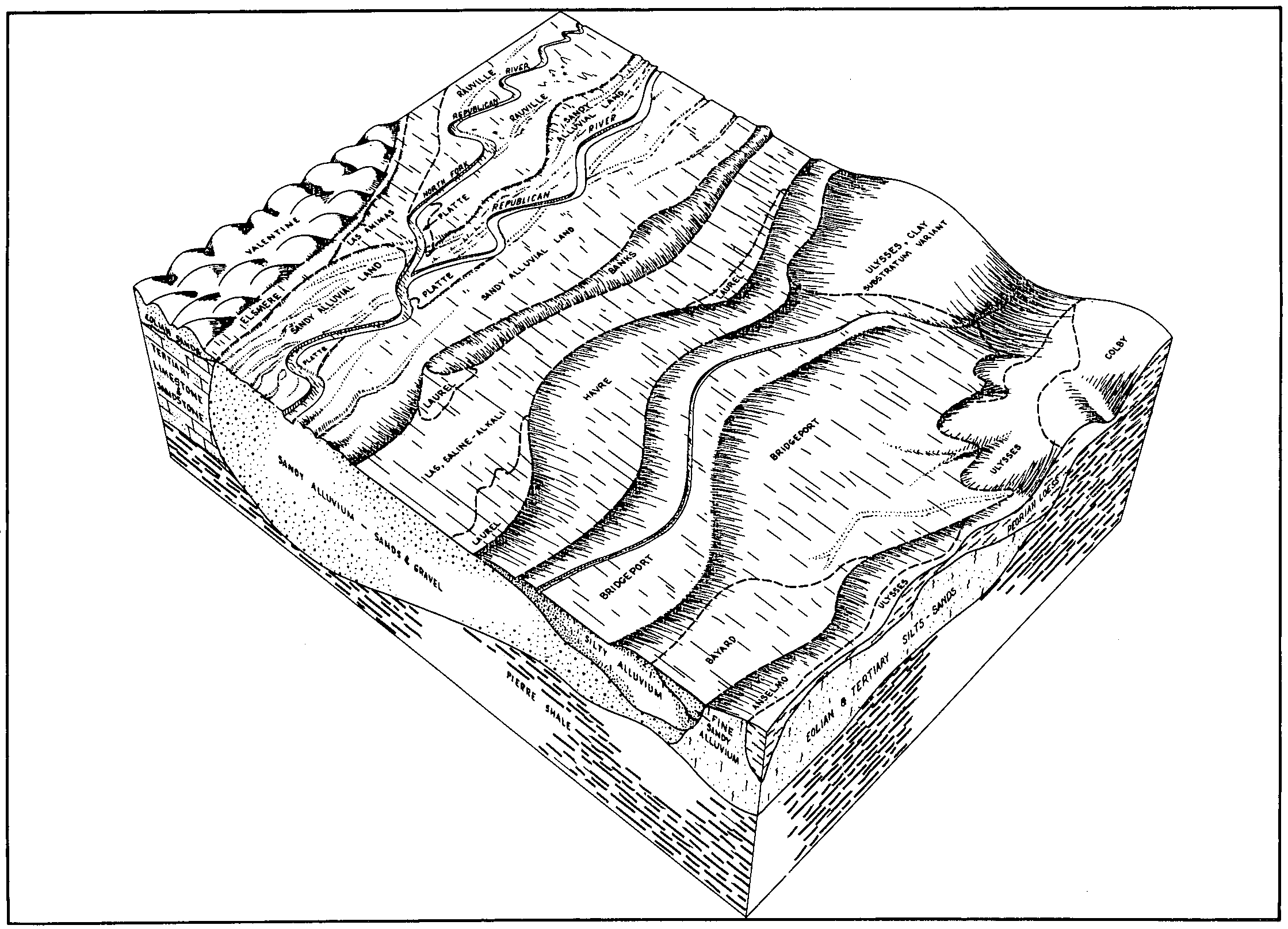
| Banks soils, 0 to 4 percent slopes, occasionally flooded | 15A | 926 | 1487231 | 1lxl6 | mt021 | 1971 | 1:24000 |
Banks fine sandy loam | 8 | 2270 | 344446 | ckf5 | mt055 | 1981 | 1:24000 |
Banks loamy fine sand, 0 to 4 percent slopes | BkB | 10327 | 3155864 | clbg | mt083 | 1973 | 1:24000 |
Banks loamy fine sand, 0 to 6 percent slopes, occasionally flooded | E4205B | 1024 | 345323 | cdq9 | mt083 | 1973 | 1:24000 |
Glendive and Banks soils | Gv | 3047 | 345436 | clg3 | mt103 | 1961 | 1:20000 |
Banks soils | Bs | 1888 | 345389 | cldl | mt103 | 1961 | 1:20000 |
Banks very fine sandy loam, 0 to 4 percent slopes | Bb | 2311 | 144791 | 4vnp | mt617 | 1958 | 1:20000 |
Chamokane and Banks soils, 0 to 4 percent slopes | Cc | 1279 | 144810 | 4vp9 | mt617 | 1958 | 1:20000 |
Banks loamy fine sand, 0 to 4 percent slopes | Ba | 976 | 144790 | 4vnn | mt617 | 1958 | 1:20000 |
Chamokane and Banks soils, 0 to 4 percent slopes, lake effect | 5A | 11 | 1716043 | 1vlp7 | mt617 | 1958 | 1:20000 |
Banks loam | 5 | 3230 | 348255 | cpd1 | mt661 | 1982 | 1:24000 |
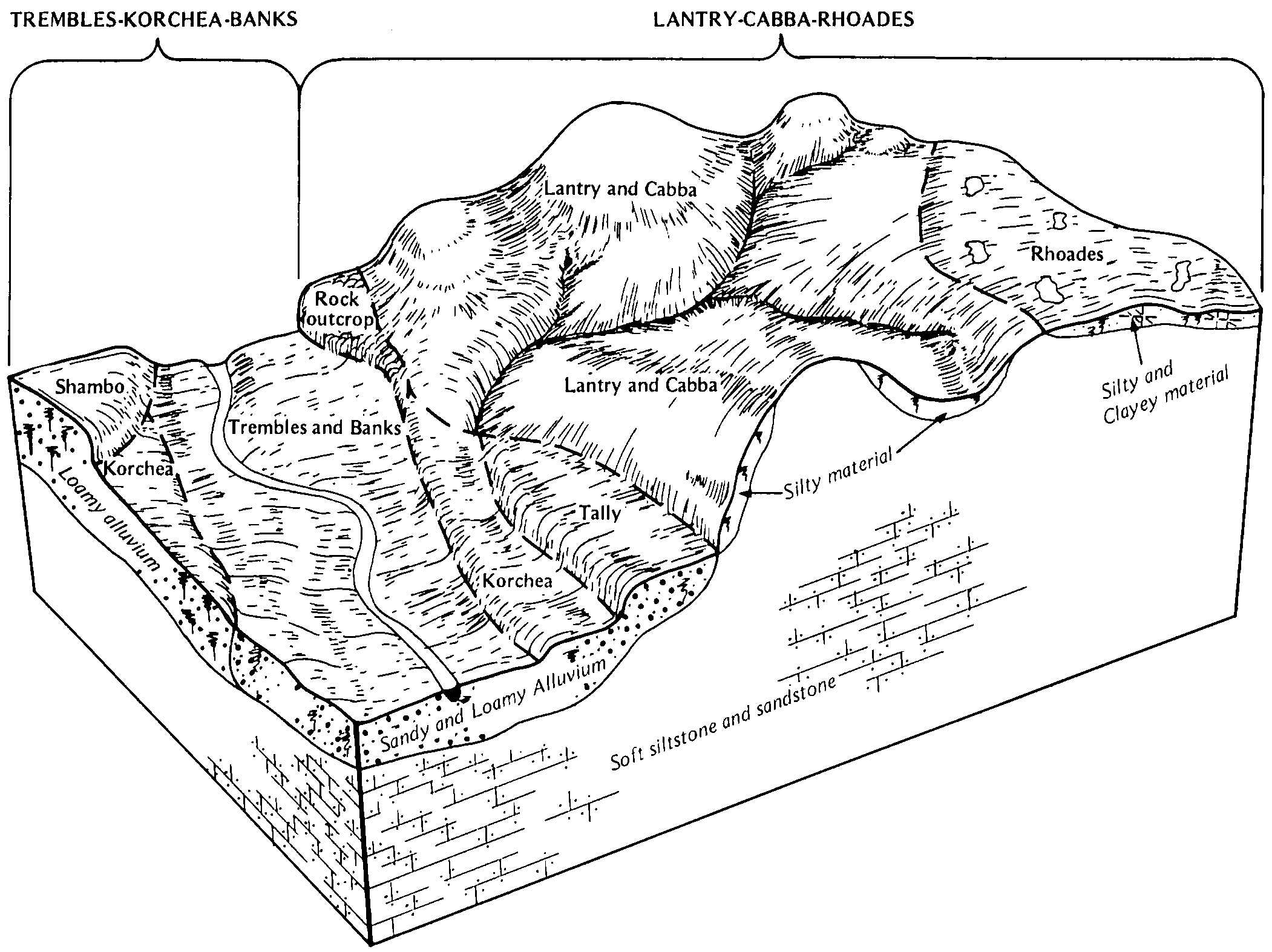
Banks-Trembles-Fluvaquents fine sandy loams, channeled, 0 to 2 percent slopes, frequently flooded | E4221A | 126 | 2755664 | 1vzw8 | nd001 | 1983 | 1:20000 |
Banks-Trembles-Fluvaquents fine sandy loams, channeled, 0 to 2 percent slopes, frequently flooded | E4221A | 280 | 2707096 | 1vzw8 | nd007 | 1998 | 1:24000 |
Banks loamy fine sand, 0 to 6 percent slopes, occasionally flooded | E4205B | 169 | 2563522 | cdq9 | nd011 | 1969 | 1:20000 |
Banks-Trembles-Fluvaquents fine sandy loams, channeled, 0 to 2 percent slopes, frequently flooded | E4221A | 42 | 2563523 | 1vzw8 | nd011 | 1969 | 1:20000 |
Banks loamy fine sand, 0 to 6 percent slopes, occasionally flooded | E4205B | 1665 | 2661678 | cdq9 | nd015 | 1967 | 1:20000 |
Banks fine sandy loam, 0 to 6 percent slopes, occasionally flooded | E4209B | 431 | 2661731 | 2qz88 | nd015 | 1967 | 1:20000 |
Banks-Trembles fine sandy loams, 0 to 2 percent slopes, occasionally flooded | E4217A | 294 | 2661732 | 2qz89 | nd015 | 1967 | 1:20000 |
Banks-Trembles-Fluvaquents fine sandy loams, channeled, 0 to 2 percent slopes, frequently flooded | E4221A | 3 | 2707250 | 1vzw8 | nd025 | 1981 | 1:20000 |
Banks-Trembles fine sandy loams, 0 to 2 percent slopes, occasionally flooded | E4217A | 6040 | 2525891 | 2qz89 | nd037 | 1985 | 1:20000 |
Banks-Trembles-Fluvaquents fine sandy loams, channeled, 0 to 2 percent slopes, frequently flooded | E4221A | 1526 | 2525850 | 1vzw8 | nd037 | 1985 | 1:20000 |
Banks loamy fine sand, 0 to 6 percent slopes, occasionally flooded | E4205B | 240 | 2759681 | cdq9 | nd037 | 1985 | 1:20000 |
Banks fine sandy loam, 0 to 6 percent slopes, occasionally flooded | E4209B | 46 | 2494655 | 2qz88 | nd037 | 1985 | 1:20000 |
Banks-Trembles-Fluvaquents fine sandy loams, channeled, 0 to 2 percent slopes, frequently flooded | E4221A | 902 | 2755690 | 1vzw8 | nd041 | 1986 | 1:20000 |
Banks fine sandy loam, slightly wet, 0 to 2 percent slopes, occasionally flooded | E4202A | 853 | 2699353 | 2r4f1 | nd053 | 2003 | 1:24000 |
Banks loamy fine sand, 0 to 6 percent slopes, occasionally flooded | E4205B | 233 | 2759724 | cdq9 | nd053 | 2003 | 1:24000 |
Seroco, hummocky-Banks, occasionally flooded loamy fine sands, 0 to 15 percent slopes | E4227D | 118 | 2699354 | 2qz8b | nd053 | 2003 | 1:24000 |
Banks loamy fine sand, 0 to 6 percent slopes, occasionally flooded | E4205B | 1087 | 2662439 | cdq9 | nd055 | 1974 | 1:20000 |
Banks-Trembles fine sandy loams, 0 to 2 percent slopes, occasionally flooded | E4217A | 639 | 2662490 | 2qz89 | nd055 | 1974 | 1:20000 |
Banks-Trembles fine sandy loams, 0 to 2 percent slopes, occasionally flooded | E4217A | 321 | 2699243 | 2qz89 | nd057 | 1976 | 1:20000 |
Banks loamy fine sand, 0 to 6 percent slopes, occasionally flooded | E4205B | 41 | 2755733 | cdq9 | nd057 | 1976 | 1:20000 |
Banks loamy fine sand, 0 to 6 percent slopes, occasionally flooded | E4205B | 5815 | 2699145 | cdq9 | nd059 | 1998 | 1:20000 |
Banks loamy fine sand, swp, 0 to 6 percent slopes, occasionally flooded | E4206B | 1385 | 2699146 | cdqn | nd059 | 1998 | 1:20000 |
Banks-Trembles fine sandy loams, 0 to 2 percent slopes, occasionally flooded | E4217A | 609 | 2525999 | 2qz89 | nd065 | 1971 | 1:20000 |
Banks loamy fine sand, 0 to 6 percent slopes, occasionally flooded | E4205B | 602 | 2525998 | cdq9 | nd065 | 1971 | 1:20000 |
Banks-Trembles fine sandy loams, 2 to 6 percent slopes, occasionally flooded | E4217B | 303 | 2526000 | 2q640 | nd065 | 1971 | 1:20000 |
Seroco, hummocky-Banks, occasionally flooded loamy fine sands, 0 to 15 percent slopes | E4227D | 167 | 2526001 | 2qz8b | nd065 | 1971 | 1:20000 |
Banks loamy fine sand, 0 to 6 percent slopes, occasionally flooded | E4205B | 2614 | 2699069 | cdq9 | nd085 | 1992 | 1:24000 |
Banks-Trembles fine sandy loams, 0 to 2 percent slopes, occasionally flooded | E4217A | 2548 | 2759707 | 2qz89 | nd085 | 1992 | 1:24000 |
Banks-Trembles-Fluvaquents fine sandy loams, channeled, 0 to 2 percent slopes, frequently flooded | E4221A | 2017 | 2699070 | 1vzw8 | nd085 | 1992 | 1:24000 |
Banks loamy fine sand, 0 to 6 percent slopes, occasionally flooded | E4205B | 912 | 2715862 | cdq9 | nd087 | 1974 | 1:20000 |
Banks-Trembles-Fluvaquents fine sandy loams, channeled, 0 to 2 percent slopes, frequently flooded | E4221A | 214 | 2758523 | 1vzw8 | nd087 | 1974 | 1:20000 |
Banks-Trembles-Fluvaquents fine sandy loams, channeled, 0 to 2 percent slopes, frequently flooded | E4221A | 3660 | 2716019 | 1vzw8 | nd089 | 1965 | 1:20000 |
Banks fine sandy loam, 0 to 6 percent slopes, occasionally flooded | E4209B | 369 | 2494654 | 2qz88 | nd089 | 1965 | 1:20000 |
Banks complex, slightly wet, 0 to 2 percent slopes, occasionally flooded | E4223A | 940 | 2662597 | 2r4f2 | nd105 | 1993 | 1:24000 |
Seroco, hummocky-Banks, occasionally flooded loamy fine sands, 0 to 15 percent slopes | E4227D | 939 | 2662595 | 2qz8b | nd105 | 1993 | 1:24000 |
Banks loamy fine sand, slightly wet, 0 to 2 percent slopes | 100 | 197 | 339011 | ccrv | nd105 | 1993 | 1:24000 |
Banks loamy fine sand, 0 to 6 percent slopes, occasionally flooded | Bb | 817 | 3256594 | 2zk46 | sd019 | 1970 | 1:24000 |
Banks fine sand | Bd | 3202 | 356133 | cyl5 | sd031 | 1986 | 1:24000 |
Trembles and Banks soils | Tr | 10639 | 354248 | cwmc | sd041 | 1972 | 1:24000 |
Banks loamy fine sand, 0 to 6 percent slopes, occasionally flooded | Bb | 3504 | 3256503 | 2zk46 | sd063 | 1984 | 1:24000 |
Banks loamy fine sand, 0 to 6 percent slopes, occasionally flooded | Bb | 20498 | 354613 | 2zk46 | sd105 | 1977 | 1:24000 |
Banks loamy fine sand, 0 to 6 percent slopes, occasionally flooded | Bb | 2732 | 355827 | 2zk46 | sd137 | 1985 | 1:24000 |
