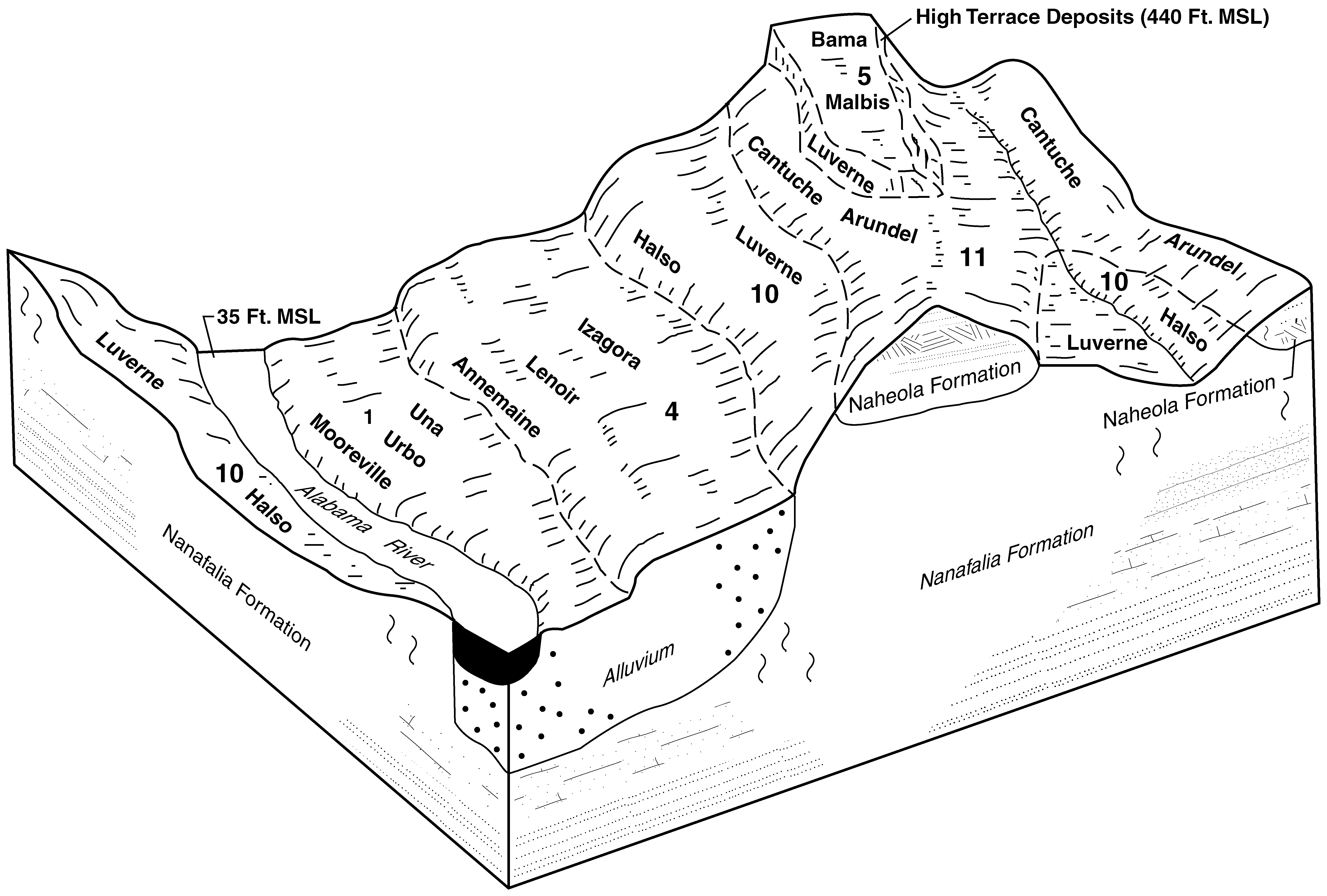
| Bama fine sandy loam, 2 to 5 percent slopes | BmB | 4112 | 3116205 | 2s69h | al001 | 1972 | 1:20000 |
Bama fine sandy loam, 2 to 5 percent slopes | BaB | 8040 | 2230309 | 2s69h | al007 | 2007 | 1:24000 |
Bama fine sandy loam, 0 to 2 percent slopes | BaA | 370 | 2230308 | 2v5lb | al007 | 2007 | 1:24000 |
Bama fine sandy loam, 2 to 5 percent slopes | BaB | 21790 | 599967 | 2s69h | al025 | 2004 | 1:24000 |
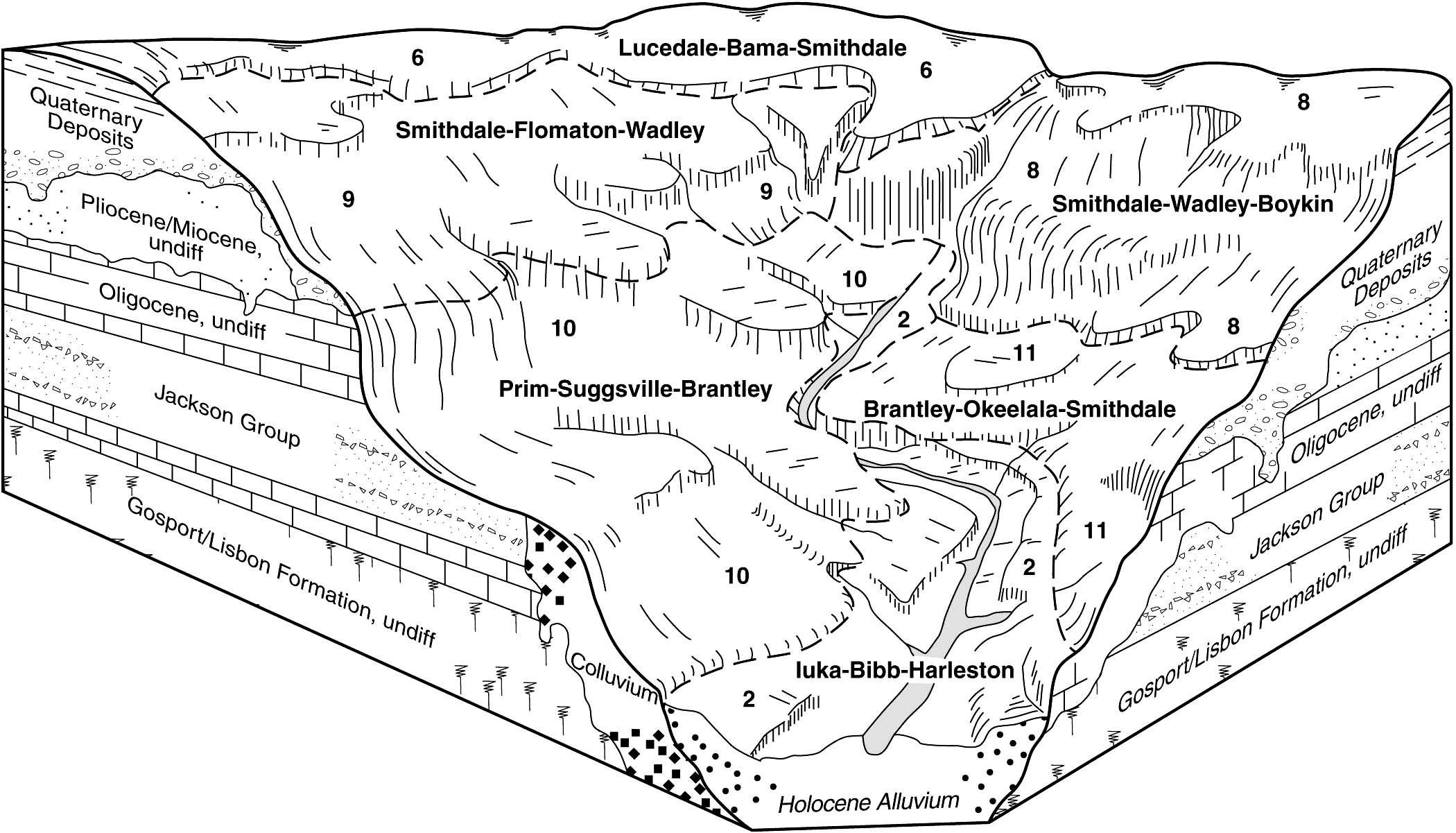
Lucedale-Bama-Urban land complex, 0 to 8 percent slopes | LuC | 1620 | 600068 | n4f1 | al025 | 2004 | 1:24000 |
Bama fine sandy loam, 2 to 5 percent slopes | 6 | 9795 | 329099 | 2s69h | al047 | 1977 | 1:20000 |
Bama fine sandy loam, 0 to 2 percent slopes | 5 | 5570 | 329088 | 2v5lb | al047 | 1977 | 1:20000 |
Bama fine sandy loam, 5 to 12 percent slopes | 7 | 3769 | 329109 | c1gf | al047 | 1977 | 1:20000 |
Bama-Urban land complex, 0 to 8 percent slopes | 8 | 411 | 329110 | 2x5r7 | al047 | 1977 | 1:20000 |
Bama fine sandy loam, 2 to 5 percent slopes | BmB | 1391 | 329230 | 30wk8 | al051 | 1948 | 1:20000 |
Bama fine sandy loam, 2 to 5 percent slopes | BaB | 14433 | 329733 | 2s69h | al065 | 2003 | 1:24000 |
Bama fine sandy loam, 0 to 2 percent slopes | BaA | 2527 | 329732 | 2v5lb | al065 | 2003 | 1:24000 |
Bama loam, 2 to 6 percent slopes | BaB | 13622 | 2494535 | 2psf4 | al075 | 2010 | 1:24000 |
Bama loam, 0 to 2 percent slopes | BaA | 418 | 2495791 | 2ptkj | al075 | 2010 | 1:24000 |
Bama fine sandy loam, 2 to 5 percent slopes | BaB | 9416 | 2514630 | 2s69h | al085 | 2011 | 1:24000 |
Bama fine sandy loam, 0 to 2 percent slopes | BaA | 5922 | 2514629 | 2v5lb | al085 | 2011 | 1:24000 |
Bama fine sandy loam, 0 to 2 percent slopes | BaA | 1542 | 330445 | 2v5lb | al087 | 1997 | 1:24000 |
Bama fine sandy loam, 2 to 5 percent slopes | BaB | 1308 | 330446 | 2s69h | al087 | 1997 | 1:24000 |
Bama fine sandy loam, 2 to 5 percent slopes | BaB | 13790 | 330557 | 2s69h | al091 | 1997 | 1:24000 |
Bama fine sandy loam, 0 to 2 percent slopes | BaA | 5670 | 330520 | 2v5lb | al091 | 1997 | 1:24000 |
Bama loam, 2 to 6 percent slopes | 2 | 920 | 330621 | c316 | al093 | 1976 | 1:20000 |
Bama fine sandy loam, 0 to 2 percent slopes | BaA | 14381 | 2994950 | 2v5lb | al097 | 2018 | 1:24000 |
Bama fine sandy loam, 2 to 5 percent slopes | BaB | 10496 | 2994949 | 2s69h | al097 | 2018 | 1:24000 |
Bama fine sandy loam, 5 to 8 percent slopes | BaC | 2809 | 2995023 | 2wtyv | al097 | 2018 | 1:24000 |
Bama-Urban land complex, 0 to 8 percent slopes | BbC | 1077 | 2995068 | 2x5r7 | al097 | 2018 | 1:24000 |
Bama fine sandy loam, 2 to 5 percent slopes | BaB | 31400 | 330822 | 2s69h | al099 | 1984 | 1:20000 |
Bama sandy loam, 5 to 10 percent slopes | BaC | 25900 | 330823 | c37q | al099 | 1984 | 1:20000 |
Bama-Urban land complex, 1 to 10 percent slopes | BbC | 2700 | 330824 | c37r | al099 | 1984 | 1:20000 |
Bama fine sandy loam, 0 to 2 percent slopes | BmA | 3659 | 330865 | 2v5lb | al101 | 1958 | 1:20000 |
Bama fine sandy loam, 2 to 5 percent slopes | BmB | 3185 | 330866 | 2s69h | al101 | 1958 | 1:20000 |
Urban land-Anthoportic udorthents-Bama complex, 5 to 8 percent slopes | UAbC | 1750 | 330867 | 30wk6 | al101 | 1958 | 1:20000 |
Bama fine sandy loam, 2 to 5 percent slopes | BaB | 4640 | 331226 | 2s69h | al105 | 1996 | 1:24000 |
Bama fine sandy loam, 0 to 2 percent slopes | BaA | 1530 | 331225 | 2v5lb | al105 | 1996 | 1:24000 |
Bama sandy loam, 2 to 5 percent slopes | BaB | 18930 | 331283 | c3qk | al107 | 1997 | 1:24000 |
Lucedale loam, 0 to 2 percent slopes | LdA | 4800 | 331288 | c3qq | al107 | 1997 | 1:24000 |
Bama loam, 0 to 2 percent slopes | BaA | 2390 | 331264 | c3py | al107 | 1997 | 1:24000 |
Bama fine sandy loam, 2 to 6 percent slopes | 6 | 28575 | 331538 | c3zs | al125 | 1980 | 1:20000 |
Bama-Urban land complex, 2 to 6 percent slopes | 8 | 6577 | 331540 | c3zv | al125 | 1980 | 1:20000 |
Bama fine sandy loam, 0 to 2 percent slopes | 5 | 2867 | 331537 | c3zr | al125 | 1980 | 1:20000 |
Bama-Urban land complex, 0 to 2 percent slopes | 7 | 1063 | 331539 | c3zt | al125 | 1980 | 1:20000 |
Bama fine sandy loam, 0 to 2 percent slopes | BaA | 3092 | 2642050 | 2v5lb | al129 | 2013 | 1:24000 |
Bama fine sandy loam, 2 to 5 percent slopes | BaB | 2131 | 2642051 | 2s69h | al129 | 2013 | 1:24000 |
Bama fine sandy loam, 5 to 8 percent slopes | BaC | 385 | 2642052 | 2wtyv | al129 | 2013 | 1:24000 |
Bama fine sandy loam, 2 to 5 percent slopes | BaB | 10920 | 331639 | 2s69h | al131 | 1997 | 1:24000 |
Bama fine sandy loam, 0 to 2 percent slopes | BaA | 3050 | 331638 | 2v5lb | al131 | 1997 | 1:24000 |
Bama fine sandy loam, 0 to 2 percent slopes | 62 | 1470 | 1425367 | 2v5lb | fl033 | 1998 | 1:24000 |
Bama fine sandy loam, 2 to 5 percent slopes | 63 | 640 | 1425368 | 2s69h | fl033 | 1998 | 1:24000 |
Bama fine sandy loam, 0 to 2 percent slopes | BaA | 335 | 2642156 | 2v5lb | ms041 | 2012 | 1:24000 |
Bama fine sandy loam, 2 to 5 percent slopes | BaB | 157 | 2642157 | 2s69h | ms041 | 2012 | 1:24000 |
Bama fine sandy loam, 0 to 2 percent slopes | 51 | 4238 | 332586 | 2v5lb | ms059 | 1997 | 1:24000 |
Bama fine sandy loam, 2 to 5 percent slopes | 52 | 1522 | 332587 | 2s69h | ms059 | 1997 | 1:24000 |
Bama fine sandy loam, 5 to 8 percent slopes | 53 | 591 | 332589 | 2wtyv | ms059 | 1997 | 1:24000 |
Bama sandy loam, 2 to 6 percent slopes | 3B | 2073 | 121025 | 41y1 | va033 | 1996 | 1:24000 |
Bama sandy loam, 0 to 2 percent slopes | 3A | 373 | 121024 | 41y0 | va033 | 1996 | 1:24000 |
Bama loam, 2 to 6 percent slopes | 2B | 5209 | 694749 | r9y8 | va101 | 1995 | 1:15840 |
Bama loam, 0 to 2 percent slopes | 2A | 140 | 694748 | r9y7 | va101 | 1995 | 1:15840 |
Bama loam, 2 to 6 percent slopes | 2B | 896 | 119646 | 40hk | va119 | 1982 | 1:15840 |
Bama sandy loam, 2 to 7 percent slopes | 8B | 516 | 120457 | 41bq | va177 | 1980 | 1:15840 |
Bama sandy loam, 7 to 15 percent slopes | 8C | 306 | 120458 | 41br | va177 | 1980 | 1:15840 |
