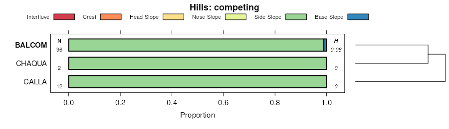
| Goldeagle-Positas-Balcom complex, 30 to 75 percent slopes | 275 | 32913 | 461618 | hhbx | ca011 | 1999 | 1:24000 |
Balcom-Ayar complex, 30 to 50 percent slopes | 271 | 907 | 461617 | hhbw | ca011 | 1999 | 1:24000 |
Balcom-Ayar complex, 15 to 30 percent slopes | 270 | 817 | 461616 | hhbv | ca011 | 1999 | 1:24000 |
Sehorn-Balcom complex, 15 to 30 percent slopes, eroded | SmE2 | 17804 | 459279 | hdxg | ca113 | 1968 | 1:20000 |
Balcom-Dibble complex, 30 to 50 percent slopes, eroded | BdF2 | 16415 | 459212 | hdv9 | ca113 | 1968 | 1:20000 |
Sehorn-Balcom complex, 2 to 15 percent slopes | SmD | 16127 | 459278 | hdxf | ca113 | 1968 | 1:20000 |
Balcom silty clay loam, 30 to 50 percent slopes, eroded | BaF2 | 12393 | 459210 | hdv7 | ca113 | 1968 | 1:20000 |
Sehorn-Balcom complex, 30 to 50 percent slopes, eroded | SmF2 | 11232 | 459280 | hdxh | ca113 | 1968 | 1:20000 |
Balcom silty clay loam, 15 to 30 percent slopes, eroded | BaE2 | 5195 | 459209 | hdv6 | ca113 | 1968 | 1:20000 |
Balcom silty clay loam, 5 to 15 percent slopes, severely eroded | BaD3 | 312 | 459208 | hdv5 | ca113 | 1968 | 1:20000 |
Balcom silty clay loam, 50 to 75 percent slopes, severely eroded | BaG3 | 264 | 459211 | hdv8 | ca113 | 1968 | 1:20000 |
Balcom-Calleguas complex, 50 to 75 percent slopes | 113 | 26000 | 457216 | hbrx | ca665 | 1977 | 1:24000 |
Balcom-Nacimiento association, moderately steep | 114 | 24500 | 457217 | hbry | ca665 | 1977 | 1:24000 |
Balcom-Nacimiento association,steep | 115 | 13720 | 457218 | hbrz | ca665 | 1977 | 1:24000 |
Balcom variant clay loam, 5 to 30 percent slopes | 114 | 1171 | 463659 | hkgr | ca666 | 1983 | 1:24000 |
Balcom-Nacimiento complex, 30 to 50 percent slopes | 102 | 30065 | 458427 | hd0z | ca667 | 2003 | 1:24000 |
Balcom-Nacimiento complex, 15 to 30 percent slopes | 101 | 20785 | 458426 | hd0y | ca667 | 2003 | 1:24000 |
Balcom loam, 50 to 75 percent slopes | 100 | 8930 | 458425 | hd0x | ca667 | 2003 | 1:24000 |
Calleguas-Balcom complex, 15 to 30 percent slopes | 112 | 3105 | 458431 | hd13 | ca667 | 2003 | 1:24000 |
Balcom-Nacimiento complex, 9 to 15 percent slopes | 103 | 600 | 458428 | hd10 | ca667 | 2003 | 1:24000 |
Castaic-Balcom complex, 30 to 50 percent slopes, eroded | CfF2 | 16377 | 457676 | hc7r | ca674 | 1968 | 1:24000 |
Castaic-Balcom complex, 50 to 65 percent slopes, eroded | CfG2 | 3731 | 457677 | hc7s | ca674 | 1968 | 1:24000 |
Castaic-Balcom complex, 15 to 30 percent slopes | CfE | 1040 | 457675 | hc7q | ca674 | 1968 | 1:24000 |
Castaic-Balcom complex, 9 to 15 percent slopes, eroded | CfD2 | 348 | 457674 | hc7p | ca674 | 1968 | 1:24000 |
Castaic-Balcom silty clay loams, 30 to 50 percent slopes, eroded | CmF2 | 12992 | 457817 | hcd9 | ca675 | 1968 | 1:24000 |
Castaic-Balcom silty clay loams, 30 to 50 percent slopes | CmF | 9309 | 457816 | hcd8 | ca675 | 1968 | 1:24000 |
Castaic-Balcom silty clay loams, 15 to 30 percent slopes | CmE | 2868 | 457815 | hcd7 | ca675 | 1968 | 1:24000 |
Castaic-Balcom silty clay loams, 50 to 65 percent slopes, eroded | CmG2 | 2670 | 457818 | hcdb | ca675 | 1968 | 1:24000 |
Castaic-Balcom silty clay loams, 9 to 15 percent slopes | CmD | 252 | 457814 | hcd6 | ca675 | 1968 | 1:24000 |
Urban land-Balcom-Xerorthents, landscaped complex, 10 to 60 percent slopes | 1249LA | | 2911687 | 2sthx | ca676 | 1975 | 1:24000 |
Xerorthents-Urban land-Balcom complex, 5 to 15 percent slopes | 139 | 7095 | 456041 | h9k0 | ca676 | 1975 | 1:24000 |
Balcom silty clay loam, 30 to 50 percent slopes, MLRA 20 | 105 | 4652 | 456007 | 2tz0v | ca676 | 1975 | 1:24000 |
Gazos-Balcom complex, 30 to 50 percent slopes | 120 | 3625 | 456022 | h9jd | ca676 | 1975 | 1:24000 |
Xerorthents-Urban land-Balcom complex, 15 to 30 percent slopes | 140 | 2946 | 456042 | h9k1 | ca676 | 1975 | 1:24000 |
Balcom silty clay loam, 15 to 30 percent slopes, MLRA 20 | 104 | 1450 | 456006 | 2tz0s | ca676 | 1975 | 1:24000 |
Balcom silty clay loam, 9 to 15 percent slopes | 103 | 615 | 456005 | h9hv | ca676 | 1975 | 1:24000 |
Xerorthents-Urban land-Balcom complex, 0 to 15 percent slopes | 531 | 575 | 735089 | snxk | ca676 | 1975 | 1:24000 |
Balcom silty clay loam, 50 to 75 percent slopes, MLRA 20 | 106 | 425 | 456008 | 2tz0t | ca676 | 1975 | 1:24000 |
Balcom-Balcom, dark surface association, 30 to 75 percent slopes | 503 | 280 | 735085 | snxf | ca676 | 1975 | 1:24000 |
Xerorthents-Urban land-Balcom complex, 0 to 30 percent slopes | 530 | 35 | 735088 | snxj | ca676 | 1975 | 1:24000 |
Balcom clay loam, 30 to 50 percent slopes | 113 | 3080 | 458014 | hcln | ca678 | 1974 | 1:24000 |
Balcom clay loam, 15 to 30 percent slopes | 112 | 2475 | 458013 | hclm | ca678 | 1974 | 1:24000 |
Bosanko-Balcom complex, 15 to 30 percent slopes | 129 | 2425 | 458030 | hcm5 | ca678 | 1974 | 1:24000 |
Balcom clay loam, 9 to 15 percent slopes | 111 | 830 | 458012 | hcll | ca678 | 1974 | 1:24000 |
Balcom-Rock outcrop complex, 15 to 50 percent slopes | 114 | 710 | 458015 | hclp | ca678 | 1974 | 1:24000 |
Bosanko-Balcom complex, 30 to 50 percent slopes | 130 | 680 | 458031 | hcm6 | ca678 | 1974 | 1:24000 |
Balcom-Rock outcrop complex, 50 to 75 percent slopes | 610 | 4495 | 466434 | hnc8 | ca691 | 2008 | 1:24000 |
Urban land-Balcom-Xerorthents, landscaped complex, 10 to 60 percent slopes | 1249LA | | 2911675 | 2sthx | ca692 | 2001 | 1:24000 |
Castaic-Balcom complex, 30 to 50 percent slopes, eroded | CfF2vt | | 3003614 | hc7r | ca692 | 2001 | 1:24000 |
Xerorthents-Urban land-Balcom complex, 0 to 15 percent slopes | 531 | 2520 | 470000 | hs29 | ca692 | 2001 | 1:24000 |
Balcom silty clay loam, 30 to 50 percent slopes, MLRA 20 | 500 | 1760 | 469993 | 2tz0v | ca692 | 2001 | 1:24000 |
Balcom-Balcom, dark surface association, 30 to 75 percent slopes | 503 | 960 | 469994 | hs23 | ca692 | 2001 | 1:24000 |
Xerorthents-Urban land-Balcom complex, 0 to 30 percent slopes | 530 | 140 | 469999 | hs28 | ca692 | 2001 | 1:24000 |
Urban land-Balcom-Xerorthents, landscaped complex, 10 to 60 percent slopes | 1249 | 1365 | 2747693 | 2sthx | ca696 | 2016 | 1:24000 |
Balcom-Nacimiento, warm complex, 30 to 75 percent slopes | 1149 | 746 | 2670254 | 2rshs | ca696 | 2016 | 1:24000 |
Balcom clay loam, 15 to 30 percent slopes | 112oc | 39 | 2911732 | hclm | ca696 | 2016 | 1:24000 |
Balcom-Nacimiento complex, 30 to 50 percent slopes | 102cp | 37 | 1412860 | 1jf64 | ca772 | 1981 | 1:24000 |
