| Bakeoven family-Lava flows-Lithic Xerorthents, mesic association, 1 to 15 percent slopes. | 118mf | 326 | 1906202 | 21zkd | ca702 | 1984 | 1:24000 |
Bakeoven family-Lava flows-Lithic Xerorthents, mesic association, 1 to 15 percent slopes. | 118 | 39296 | 470438 | hsjf | ca703 | 1983 | 1:24000 |
Wrentham-Bakeoven families association, 10 to 40 percent slopes. | 276 | 5270 | 470589 | hsp9 | ca703 | 1983 | 1:24000 |
Rock outcrop-Rubble land-Bakeoven family association, 40 to 90 percent slopes. | 240 | 4880 | 470554 | hsn5 | ca703 | 1983 | 1:24000 |
Bakeoven-Skukel families-Lava flows association, 1 to 15 percent slopes. | 122 | 4350 | 470441 | hsjj | ca703 | 1983 | 1:24000 |
Bakeoven family-Rock outcrop association, 20 to 60 percent slopes. | 120 | 4280 | 470439 | hsjg | ca703 | 1983 | 1:24000 |
Rock outcrop-Bakeoven-Wenatchee families association, 20 to 60 percent slopes. | 239 | 3751 | 470553 | hsn4 | ca703 | 1983 | 1:24000 |
Bakeoven family-Rock outcrop-Wenatchee family association, 1 to 20 percent slopes. | 121 | 2420 | 470440 | hsjh | ca703 | 1983 | 1:24000 |
Castlevale-Bakeoven families complex, 2 to 8 inch pumice overburden, 1 to 10 percent slopes. | 139 | 2080 | 470458 | hsk2 | ca703 | 1983 | 1:24000 |
Bakeoven family-Lithic Xerorthents-Sur family, moderately deep complex, 45 to 80 percent slopes | 95 | 17970 | 465392 | hm8n | ca776 | 1981 | 1:24000 |
Bakeoven-Sur, moderately deep families complex, 50 to 75 percent slopes | 620 | 9560 | 465363 | hm7q | ca776 | 1981 | 1:24000 |
Bakeoven-Watama complex, 10 to 35 percent slopes | 11 | 649 | 79574 | 2nsx | id611 | 1994 | 1:24000 |
Bakeoven-Reywat complex, 2 to 30 percent slopes | 13 | 48312 | 81129 | 2qf2 | id656 | 1992 | 1:24000 |
Bakeoven-Reywat-Rock outcrop complex, 30 to 60 percent slopes | 14 | 41369 | 81140 | 2qff | id656 | 1992 | 1:24000 |
Gem-Bakeoven complex, 2 to 30 percent slopes | 71 | 31587 | 81268 | 2qkk | id656 | 1992 | 1:24000 |
Gem-Bakeoven complex, 30 to 60 percent slopes | 72 | 14644 | 81269 | 2qkl | id656 | 1992 | 1:24000 |
Gross-Bakeoven complex, 30 to 65 percent slopes | 88 | 10772 | 81286 | 2ql4 | id656 | 1992 | 1:24000 |
Rock outcrop-Bakeoven complex, 60 to 80 percent slopes | 180 | 10196 | 81185 | 2qgw | id656 | 1992 | 1:24000 |
Gross-Bakeoven complex, 30 to 65 percent slopes, stony | 89 | 9316 | 81287 | 2ql5 | id656 | 1992 | 1:24000 |
Reywat-Bakeoven complex, 30 to 60 percent slopes | RBF | 6376 | 81385 | 2qpb | id659 | 1971 | 1:20000 |
Gross-Bakeoven complex, 30 to 65 percent slopes | GRF | 3811 | 81322 | 2qm9 | id659 | 1971 | 1:20000 |
Reywat-Bakeoven complex, 2 to 30 percent slopes | RBE | 3333 | 81384 | 2qp9 | id659 | 1971 | 1:20000 |
Gem-Bakeoven complex 30 to 65 percent slopes | GBF | 2814 | 81320 | 2qm7 | id659 | 1971 | 1:20000 |
Gem-Bakeoven complex, 2 to 30 percent slopes | GBE | 2796 | 81319 | 2qm6 | id659 | 1971 | 1:20000 |
Ruckles-Bakeoven extremely stony loams, 2 to 30 percent slopes | RVE | 1386 | 81387 | 2qpd | id659 | 1971 | 1:20000 |
Ruckles-Bakeoven extremely stony loams, 30 to 65 percent slopes | RVF | 565 | 81388 | 2qpf | id659 | 1971 | 1:20000 |
Rock outcrop-Bakeoven complex, 60 to 80 percent slopes | RKG | 563 | 81386 | 2qpc | id659 | 1971 | 1:20000 |
Gem and Bakeoven soils, 30 to 60 percent slopes, extremely stony | GnF | 12103 | 80547 | 2pt9 | id660 | 1962 | 1:15840 |
Gem and Bakeoven soils, 0 to 30 percent slopes, extremely stony | GnE | 8675 | 80546 | 2pt8 | id660 | 1962 | 1:15840 |
Bakeoven-Rock outcrop-Lickskillet complex, 30 to 60 percent slopes | BaF | 7209 | 80487 | 2prc | id660 | 1962 | 1:15840 |
Bakeoven-Lickskillet-Rock outcrop complex, 0 to 30 percent slopes | BaE | 5092 | 80486 | 2prb | id660 | 1962 | 1:15840 |
Bakeoven-Rock outcrop-Lickskillet complex, 60 to 80 percent slopes | BaG | 2937 | 80488 | 2prd | id660 | 1962 | 1:15840 |
Lickskillet-Bakeoven complex, 30 to 60 percent slopes, extremely stony | LxF | 2122 | 80614 | 2pwg | id660 | 1962 | 1:15840 |
Gross and Bakeoven soils, 30 to 60 percent slopes, very stony | GsF | 2076 | 80551 | 2ptf | id660 | 1962 | 1:15840 |
Gross and Bakeoven soils, 60 to 90 percent slopes, very stony | GsG | 898 | 80552 | 2ptg | id660 | 1962 | 1:15840 |
Lickskillet-Bakeoven complex, 0 to 30 percent slopes, extremely stony | LxE | 270 | 80613 | 2pwf | id660 | 1962 | 1:15840 |
Bakeoven-Reywat-Rock outcrop complex, 30 to 60 percent slopes | 656014 | 773 | 3332358 | 2qff | id700 | | 1:24000 |
Gem-Bakeoven complex, 30 to 60 percent slopes | 656072 | 376 | 3332388 | 2qkl | id700 | | 1:24000 |
Gem-Bakeoven complex, 2 to 30 percent slopes | 656071 | 113 | 3332387 | 2qkk | id700 | | 1:24000 |
Rock outcrop-Bakeoven complex, 60 to 80 percent slopes | 656180 | 23 | 3332396 | 2qgw | id700 | | 1:24000 |
Bakeoven-Condon complex, 2 to 20 percent slopes | 2D | 34946 | 61064 | 21jt | or021 | 1978 | 1:24000 |
Bakeoven-Morrow complex, 2 to 20 percent slopes | 3D | 19282 | 61086 | 21kj | or021 | 1978 | 1:24000 |
Bakeoven very cobbly loam, 2 to 20 percent slopes | 1D | 3454 | 61050 | 21jc | or021 | 1978 | 1:24000 |
Condon-Bakeoven complex, 2 to 20 percent slopes | 10C | 58103 | 61549 | 221g | or055 | 1992 | 1:24000 |
Lickskillet-Bakeoven complex, 2 to 20 percent slopes | 17C | 8961 | 61556 | 221p | or055 | 1992 | 1:24000 |
Bakeoven very stony loam, 2 to 20 percent slopes | 6C | 5052 | 61589 | 222r | or055 | 1992 | 1:24000 |
Bakeoven-Ruckles complex, 2 to 12 percent slopes | 10C | 4527 | 62070 | 22l8 | or604 | 1988 | 1:24000 |
Lickskillet-Bakeoven complex, 2 to 20 percent slopes | 172 | 6529 | 3434689 | 2mpx | or618 | | 1:24000 |
Bakeoven-Rubble land complex, 2 to 20 percent slopes | 171 | 760 | 3434954 | 2mp5 | or618 | | 1:24000 |
Bakeoven-Agency-Madras complex, 0 to 3 percent slopes | 7A | 17529 | 63864 | 24g4 | or620 | 1992 | 1:24000 |
Bakeoven very cobbly loam, 0 to 3 percent slopes | 6A | 1408 | 63846 | 24fk | or620 | 1992 | 1:24000 |
Gooserock-Drinkwater-Bakeoven complex, 5 to 25 percent slopes | 102D | 327 | 3425051 | 26gw | or627 | | 1:24000 |
Gooserock-Drinkwater-Bakeoven complex, 40 to 60 percent slopes | 102E | 183 | 3425163 | 26gv | or627 | | 1:24000 |
Bakeoven-Ruckles-Ruclick complex, 2 to 25 percent slopes | 8000 | 43218 | 2486771 | 2pgpf | or645 | | 1:24000 |
Locey-Bakeoven-Lookout complex, 5 to 15 percent slopes | 8008 | 12309 | 2482086 | 2p9t9 | or645 | | 1:24000 |
Bakeoven, stony surface-Rubble land-Wrentham, very stone surface complex, 4 to 33 percent slopes | 7032 | 11139 | 3459404 | 31xvq | or645 | | 1:24000 |
Ruclick-Bakeoven-Ruckles complex, 8 to 40 percent slopes | 8006 | 10231 | 2482082 | 2p9t5 | or645 | | 1:24000 |
Kuhl-Elijah-Bakeoven, stony surface complex, 1 to 12 percent slopes | 7033 | 5896 | 3459406 | 31xvs | or645 | | 1:24000 |
Bakeoven-Gwinly-Rock outcrop complex, 10 to 40 percent south slopes | 8041 | 3900 | 2564836 | 2qxxj | or645 | | 1:24000 |
Bakeoven, very stony surface-Olac complex, 9 to 27 percent slopes | 8050 | 2926 | 3312679 | 31jf0 | or645 | | 1:24000 |
Darkrock-Dougal-Bakeoven, stony surface complex, 2 to 14 percent slopes | 8060 | 2371 | 3312669 | 30dkv | or645 | | 1:24000 |
Bakeoven-Robinette complex, 6 to 25 percent slopes | 8054 | 2357 | 3312681 | 31jf4 | or645 | | 1:24000 |
Bakeoven-Morrow complex, 2 to 20 percent slopes | 3D | 31001 | 61325 | 21t7 | or648 | 1977 | 1:24000 |
Bakeoven-Valby complex, 2 to 20 percent slopes | 4D | 13999 | 61345 | 21tw | or648 | 1977 | 1:24000 |
Bakeoven very cobbly loam, 2 to 20 percent slopes | 2D | 2592 | 61308 | 21sp | or648 | 1977 | 1:24000 |
Condon-Bakeoven complex, 2 to 20 percent slopes | 81D | 135 | 61416 | 21x5 | or648 | 1977 | 1:24000 |
Bakeoven-Condon complex, 2 to 20 percent slopes | BcC | 95081 | 62881 | 23ff | or666 | 1970 | 1:31680 |
Bakeoven very cobbly loam, 2 to 20 percent slopes | BaC | 45915 | 62880 | 23fd | or666 | 1970 | 1:31680 |
Condon-Bakeoven complex, 2 to 20 percent slopes | CoC | 40122 | 62884 | 23fj | or666 | 1970 | 1:31680 |
Bakeoven-Rubble land complex, 2 to 20 percent slopes | 171 | 1420 | 3472445 | 2mp5 | or666 | 1970 | 1:31680 |
Lickskillet-Bakeoven complex, 2 to 20 percent slopes | 172 | 358 | 3472435 | 2mpx | or666 | 1970 | 1:31680 |
Morrow-Bakeoven complex, 2 to 20 percent slopes | 59D | 20667 | 64525 | 254g | or667 | 1984 | 1:20000 |
Condon-Bakeoven complex, 2 to 20 percent slopes | 21D | 11782 | 64469 | 252n | or667 | 1984 | 1:20000 |
Bakeoven-Condon complex, 2 to 20 percent slopes | 3D | 37272 | 62987 | 23jv | or673 | 1975 | 1:20000 |
Bakeoven-Watama complex, 0 to 12 percent slopes | 5C | 21477 | 63032 | 23l9 | or673 | 1975 | 1:20000 |
Bakeoven-Maupin complex, 0 to 12 percent slopes | 4C | 10800 | 63010 | 23kl | or673 | 1975 | 1:20000 |
Bakeoven very cobbly loam, 2 to 20 percent slopes | 2D | 5677 | 62975 | 23jg | or673 | 1975 | 1:20000 |
Condon-Bakeoven complex, 2 to 20 percent slopes | 18D | 4796 | 62952 | 23hq | or673 | 1975 | 1:20000 |
Bakeoven-Maupin complex, 0 to 8 percent slopes | 8 | 10536 | 63352 | 23xm | or674 | 1993 | 1:24000 |
Bakeoven extremely gravelly loam, 0 to 8 percent slopes | 5 | 5108 | 63316 | 23wg | or674 | 1993 | 1:24000 |
Bakeoven very cobbly loam, 2 to 15 percent slopes | 7 | 1501 | 63341 | 23x8 | or674 | 1993 | 1:24000 |
Bakeoven extremely stony loam, 0 to 8 percent slopes | 6 | 622 | 63330 | 23wx | or674 | 1993 | 1:24000 |
Bakeoven-Morrow complex, 2 to 20 percent slopes | 3Dmg | 1530 | 3391640 | 21bq0 | or677 | | 1:24000 |
Gooserock-Drinkwater-Bakeoven complex, 5 to 25 percent slopes | 102D | 1331 | 3421932 | 26gw | or677 | | 1:24000 |
Gooserock-Drinkwater-Bakeoven complex, 40 to 60 percent slopes | 102E | 102 | 3424773 | 26gv | or677 | | 1:24000 |
Bakeoven-Touhey complex, 0 to 25 percent slopes | 47 | 1158 | 699330 | rgq1 | wa017 | 1998 | 1:12000 |
Bakeoven very cobbly loam, 0 to 35 percent slopes | 44 | 535 | 699277 | rgnb | wa017 | 1998 | 1:12000 |
Bakeoven-Lickskillet-Zen complex, 5 to 25 percent slopes | 45 | 461 | 699282 | rgnh | wa017 | 1998 | 1:12000 |
Bakeoven-Roloff complex, 0 to 25 percent slopes | 46 | 209 | 699322 | rgps | wa017 | 1998 | 1:12000 |
Badge-Bakeoven complex, 25 to 55 percent slopes | 37 | 83 | 699271 | rgn4 | wa017 | 1998 | 1:12000 |
Roloff-Bakeoven complex, 5 to 25 percent slopes | 304 | 14 | 699484 | rgw0 | wa017 | 1998 | 1:12000 |
Starbuck-Bakeoven-Rock outcrop complex, 0 to 45 percent slopes | 362 | 13 | 699516 | rgx1 | wa017 | 1998 | 1:12000 |
Lickskillet-Bakeoven complex, 0 to 35 percent slopes | 52 | 105 | 71781 | 2dpj | wa021 | 1994 | 1:20000 |
Bakeoven-Roloff complex, 0 to 25 percent slopes | 22 | 67799 | 68794 | 29l5 | wa025 | 1979 | 1:24000 |
Starbuck-Bakeoven-Rock outcrop complex, 0 to 45 percent slopes | 143 | 65576 | 68739 | 29jd | wa025 | 1979 | 1:24000 |
Bakeoven very cobbly loam, 0 to 35 percent slopes | 18 | 20129 | 68779 | 29kp | wa025 | 1979 | 1:24000 |
Bakeoven-Lickskillet-Zen complex, 5 to 25 percent slopes | 21 | 18224 | 68793 | 29l4 | wa025 | 1979 | 1:24000 |
Roloff-Bakeoven complex, 5 to 25 percent slopes | 112 | 12776 | 68705 | 29h9 | wa025 | 1979 | 1:24000 |
Bakeoven-Anders complex, 0 to 15 percent slopes | 19 | 10944 | 68790 | 29l1 | wa025 | 1979 | 1:24000 |
Bakeoven-Touhey complex, 0 to 25 percent slopes | 23 | 3853 | 68795 | 29l6 | wa025 | 1979 | 1:24000 |
Badge-Bakeoven complex, 25 to 55 percent slopes | 13 | 940 | 68724 | 29hx | wa025 | 1979 | 1:24000 |
Bakeoven-Condon complex, 0 to 25 percent slopes | 20 | 820 | 68792 | 29l3 | wa025 | 1979 | 1:24000 |
Roloff-Bakeoven-Rock outcrop complex, 0 to 15 percent slopes | 65 | 156805 | 68664 | 29fz | wa043 | 1978 | 1:24000 |
Anders-Bakeoven-Rock outcrop complex, 0 to 15 percent slopes | 3 | 146815 | 68625 | 29dq | wa043 | 1978 | 1:24000 |
Badge-Bakeoven-Rock outcrop complex, very steep | 4 | 53920 | 68636 | 29f2 | wa043 | 1978 | 1:24000 |
Bakeoven very cobbly loam, 0 to 7 percent slopes | 11 | 4675 | 68605 | 29d2 | wa043 | 1978 | 1:24000 |
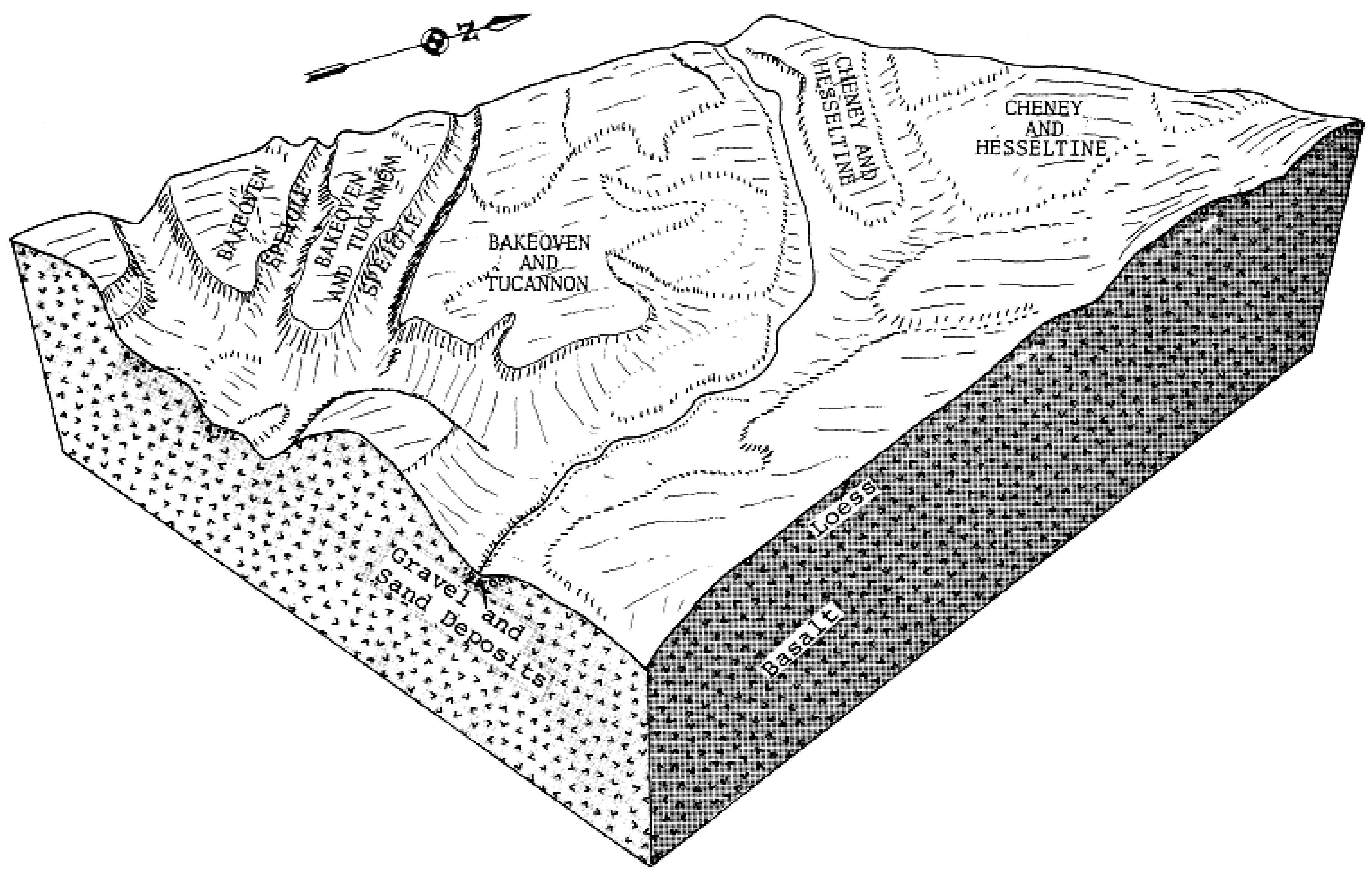
Bakeoven-Tucannon complex, 0 to 30 percent slopes | 14 | 15634 | 68507 | 298x | wa075 | 1975 | 1:20000 |
Tucannon-Bakeoven complex, 0 to 30 percent slopes | 114 | 7436 | 68494 | 298h | wa075 | 1975 | 1:20000 |
Magallon rocky very fine sandy loam, basalt substratum, 0 to 30 percent slopes | MgD | 80 | 69737 | 2bkl | wa613 | 1967 | 1:20000 |
Magallon very rocky very fine sandy loam, 0 to 30 percent slopes | MvD | 70 | 69739 | 2bkn | wa613 | 1967 | 1:20000 |
Lickskillet-Bakeoven complex, 10 to 50 percent slopes | LkF | 19902 | 69813 | 2bn1 | wa623 | 1970 | 1:20000 |
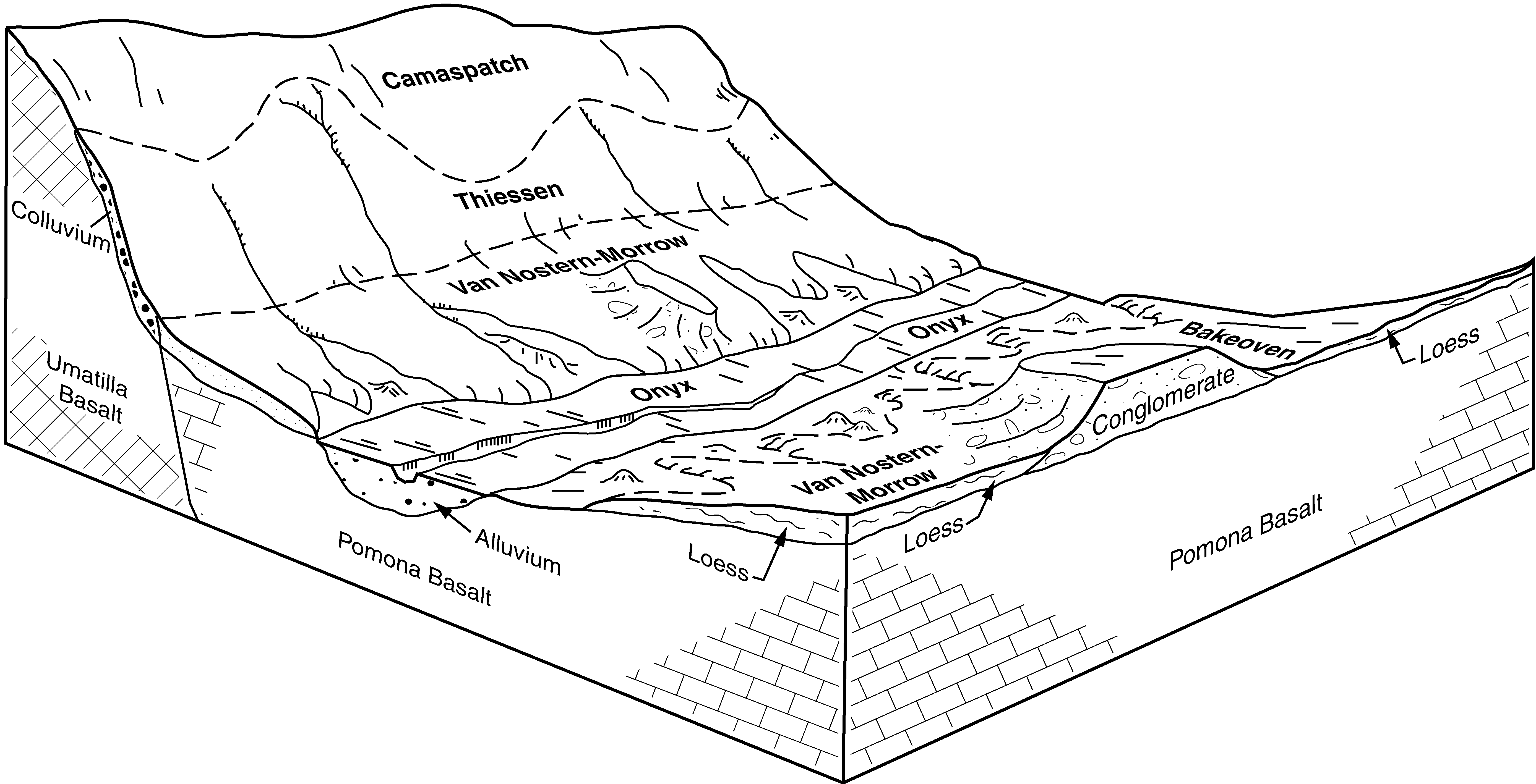
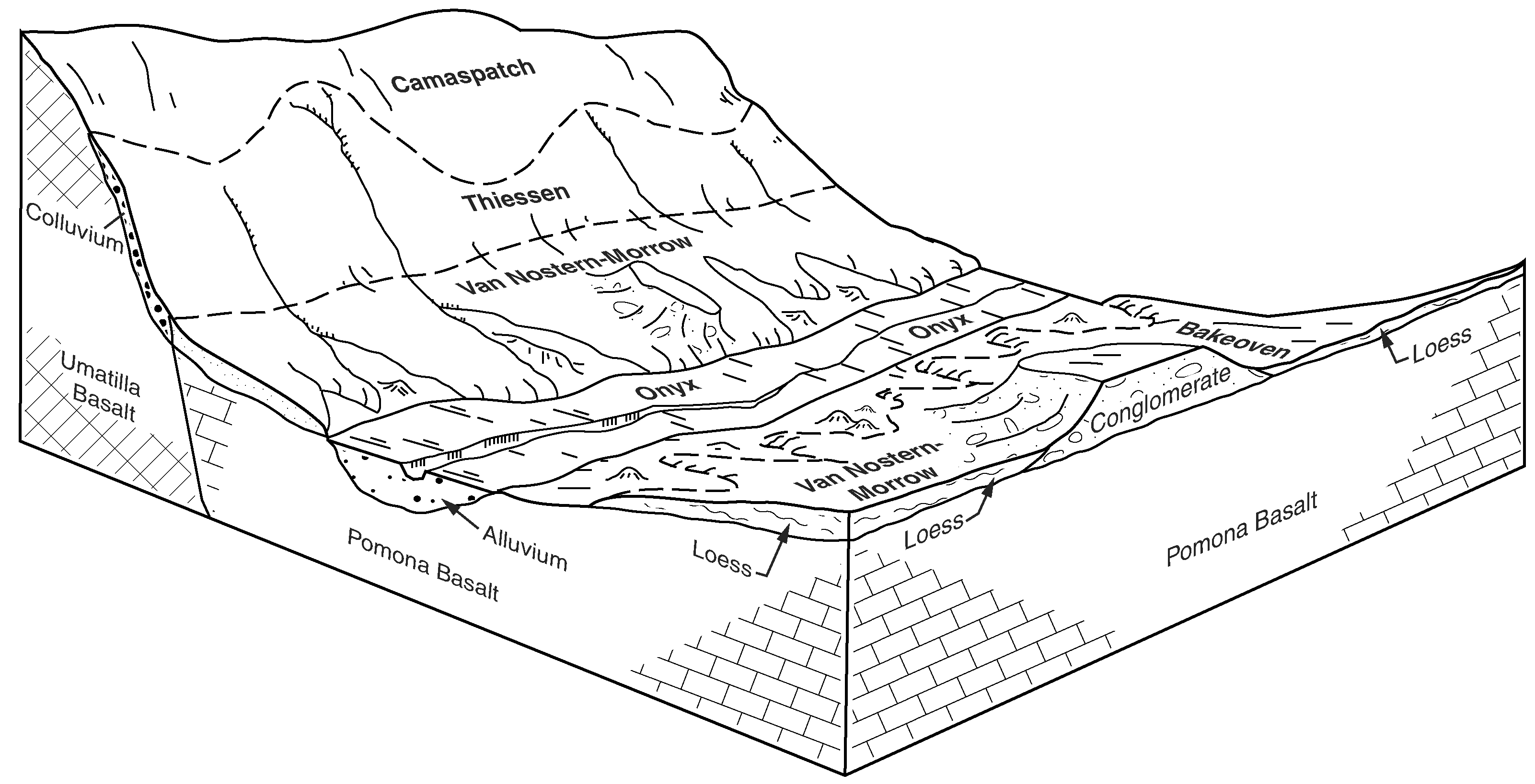
Van Nostern-Bakeoven complex, 2 to 15 percent slopes | 255 | 18430 | 76239 | 2kbb | wa639 | 2003 | 1:24000 |
Bakeoven very cobbly loam, 0 to 15 percent slopes | 487 | 16040 | 76353 | 2kg0 | wa639 | 2003 | 1:24000 |
Mikkalo-Bakeoven complex, 2 to 15 percent slopes | 585 | 11939 | 76398 | 2khg | wa639 | 2003 | 1:24000 |
Morrow-Bakeoven complex, 2 to 15 percent slopes | 155 | 6729 | 76182 | 2k8h | wa639 | 2003 | 1:24000 |
Prosser-Bakeoven complex, 2 to 15 percent slopes | 277 | 2633 | 76253 | 2kbs | wa639 | 2003 | 1:24000 |
Mikkalo-Bakeoven complex, 15 to 30 percent slopes | 584 | 1474 | 76397 | 2khf | wa639 | 2003 | 1:24000 |
Van Nostern-Bakeoven complex, 15 to 30 percent slopes | 266 | 1384 | 76247 | 2kbl | wa639 | 2003 | 1:24000 |
Selah-Bakeoven complex 2 to 15 percent slopes | 365 | 641 | 76307 | 2kdj | wa639 | 2003 | 1:24000 |
Bakeoven very cobbly loam, 15 to 30 percent slopes | 485 | 66 | 76352 | 2kfz | wa639 | 2003 | 1:24000 |
Bakeoven-Timentwa-Rock outcrop complex, 0 to 30 percent slopes | 28 | 8021 | 70411 | 2c8b | wa648 | 1987 | 1:24000 |
Timentwa-Bakeoven-Rock outcrop complex, 0 to 30 percent slopes | 479 | 6656 | 70632 | 2chg | wa648 | 1987 | 1:24000 |
Bakeoven-Olical complex, 0 to 30 percent slopes | 27 | 1125 | 70400 | 2c7z | wa648 | 1987 | 1:24000 |
Conconully-Bakeoven complex, 3 to 25 percent slopes | 99 | 950 | 70740 | 2cly | wa648 | 1987 | 1:24000 |
Bakeoven very cobbly silt loam, 2 to 25 percent slopes | 26 | 288 | 70389 | 2c7m | wa648 | 1987 | 1:24000 |
Magallon rocky very fine sandy loam, basalt substratum, 0 to 30 percent slopes | MgD | 6740 | 71360 | 2d7y | wa671 | 1961 | 1:31680 |
Magallon very rocky very fine sandy loam, 0 to 30 percent slopes | MvD | 3624 | 71366 | 2d84 | wa671 | 1961 | 1:31680 |
Magallon very rocky very fine sandy loam, 30 to 60 percent slopes | MvF | 1403 | 71367 | 2d85 | wa671 | 1961 | 1:31680 |
Magallon rocky very fine sandy loam, basalt substratum, 30 to 60 percent slopes | MgF | 979 | 71361 | 2d7z | wa671 | 1961 | 1:31680 |
Bakeoven very cobbly silt loam, 0 to 30 percent slopes | 3 | 14609 | 68996 | 29sp | wa677 | 1979 | 1:24000 |
Bakeoven very cobbly silt loam, 0 to 30 percent slopes | 215 | 331 | 71270 | 2d51 | wa681 | 1994 | 1:24000 |