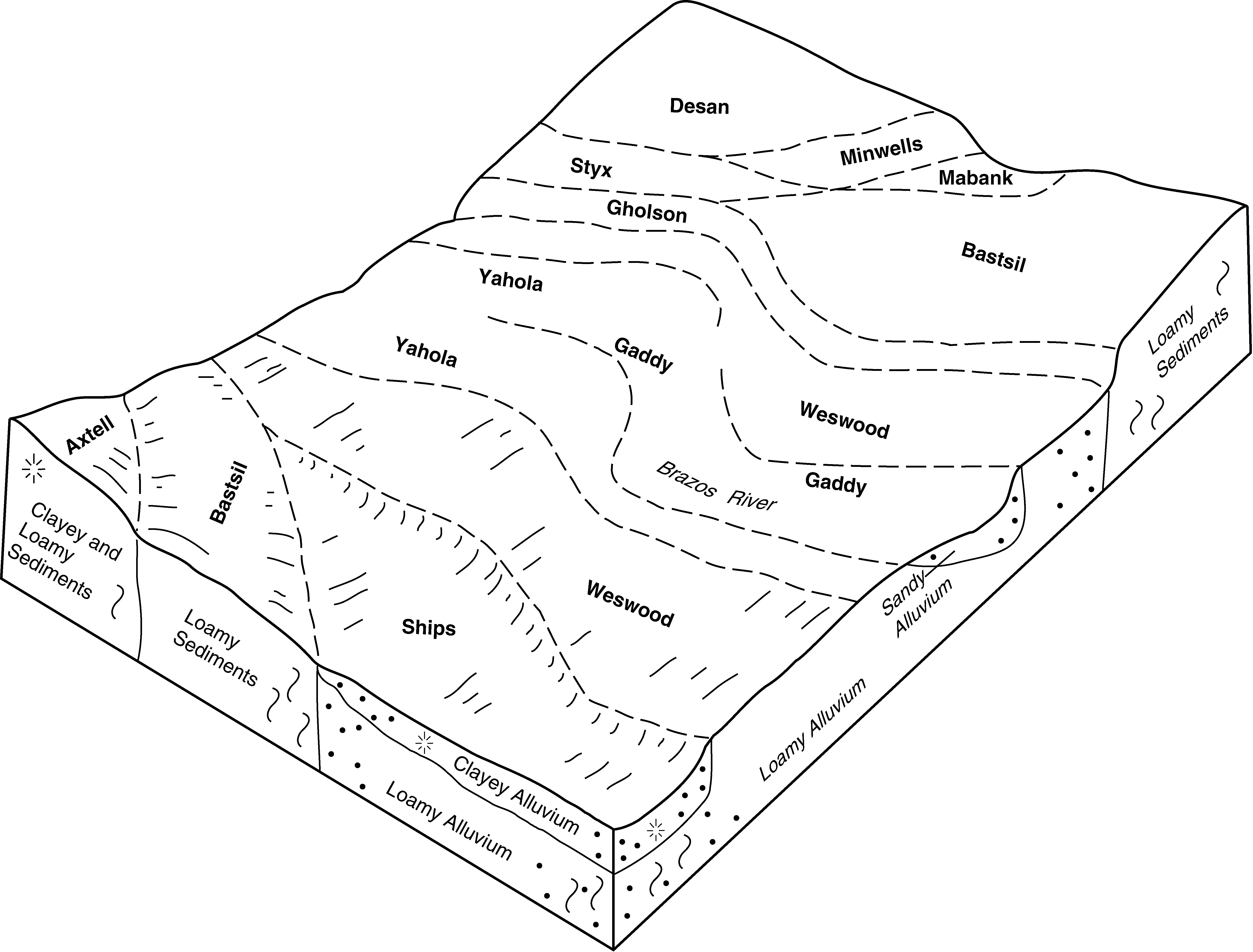
| Axtell fine sandy loam, 5 to 12 percent slopes | AtE | 8307 | 575119 | 2shg7 | tx001 | 1970 | 1:20000 |
Axtell fine sandy loam, 1 to 3 percent slopes | AtB | 4691 | 575117 | 2shg6 | tx001 | 1970 | 1:20000 |
Axtell fine sandy loam, 2 to 5 percent slopes, moderately eroded | AtC2 | 2690 | 575118 | 2shgd | tx001 | 1970 | 1:20000 |
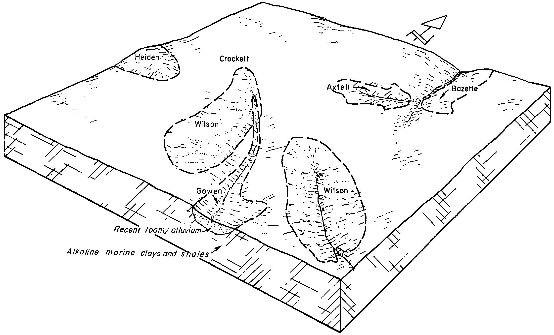
Axtell-Derly, occasionally ponded complex, 0 to 1 percent slopes | AwA | 2375 | 575120 | m9g8 | tx001 | 1970 | 1:20000 |
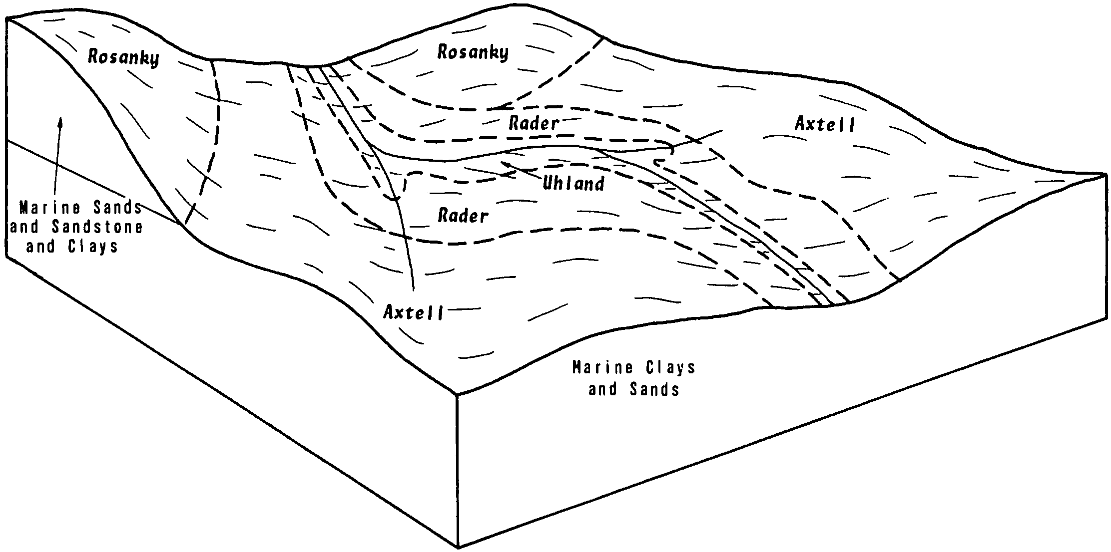
Axtell fine sandy loam, 0 to 1 percent slopes | AfA | 1455 | 393266 | 2shg5 | tx021 | 1972 | 1:24000 |
Axtell fine sandy loam, 1 to 3 percent slopes | AxB | 762 | 391069 | 2shg6 | tx027 | 1972 | 1:24000 |
Axtell fine sandy loam, 1 to 3 percent slopes | AxB | 3812 | 363174 | 2shg6 | tx041 | 1993 | 1:20000 |
Axtell fine sandy loam, 1 to 4 percent slopes | AxB | 3831 | 363425 | 2shg9 | tx051 | 1994 | 1:24000 |
Axtell-Urban land complex, 1 to 5 percent slopes | 13 | 4438 | 364793 | d7lj | tx113 | 1975 | 1:20000 |
Axtell fine sandy loam, 1 to 3 percent slopes | 11 | 2256 | 364791 | 2shg6 | tx113 | 1975 | 1:20000 |
Axtell fine sandy loam, 2 to 5 percent slopes, moderately eroded | 12 | 1462 | 364792 | 2shgd | tx113 | 1975 | 1:20000 |
Axtell fine sandy loam, 0 to 1 percent slopes | 10 | 539 | 364790 | 2shg5 | tx113 | 1975 | 1:20000 |
Axtell fine sandy loam, 1 to 3 percent slopes | 8 | 8245 | 365492 | 2shg6 | tx145 | 1975 | 1:20000 |
Axtell fine sandy loam, 2 to 5 percent slopes, moderately eroded | 9 | 5230 | 365493 | 2shgd | tx145 | 1975 | 1:20000 |
Axtell and Crockett soils, 2 to 8 percent slopes, severely eroded | 10 | 1620 | 365427 | d87z | tx145 | 1975 | 1:20000 |
Axtell fine sandy loam, 0 to 1 percent slopes | 7 | 984 | 365491 | 2shg5 | tx145 | 1975 | 1:20000 |
Axtell fine sandy loam, 1 to 5 percent slopes | AxB | 4282 | 375369 | 2shgc | tx161 | 1986 | 1:24000 |
Axtell fine sandy loam, 5 to 12 percent slopes | AxD | 1088 | 375370 | 2shg7 | tx161 | 1986 | 1:24000 |
Axtell gravelly fine sandy loam, 1 to 3 percent slopes | AxB | 1421 | 366542 | d9dy | tx177 | 1997 | 1:24000 |
Axtell gravelly fine sandy loam, 5 to 12 percent slopes | AxE | 1039 | 366544 | d9f0 | tx177 | 1997 | 1:24000 |
Axtell gravelly fine sandy loam, 3 to 5 percent slopes | AxC | 970 | 366543 | d9dz | tx177 | 1997 | 1:24000 |
Axtell fine sandy loam, 1 to 5 percent slopes | AxC | 12565 | 366732 | 2shgc | tx185 | 1988 | 1:24000 |
Axtell fine sandy loam, 5 to 12 percent slopes | AxD | 2102 | 366734 | 2shg7 | tx185 | 1988 | 1:24000 |
Axtell fine sandy loam, 2 to 5 percent slopes, moderately eroded | AxC2 | 898 | 366733 | 2shgd | tx185 | 1988 | 1:24000 |
Axtell loam, 1 to 5 percent slopes | 1 | 28867 | 367598 | 2shgb | tx213 | 1978 | 1:20000 |
Axtell loam, 5 to 12 percent slopes | 2 | 23140 | 367609 | 2shg8 | tx213 | 1978 | 1:20000 |
Axtell fine sandy loam, 1 to 3 percent slopes | 10 | 2682 | 367721 | 2shg6 | tx217 | 1975 | 1:20000 |
Axtell fine sandy loam, 2 to 5 percent slopes, moderately eroded | 11 | 1937 | 367722 | 2shgd | tx217 | 1975 | 1:20000 |
Axtell fine sandy loam, 0 to 1 percent slopes | 9 | 880 | 367800 | 2shg5 | tx217 | 1975 | 1:20000 |
Axtell loam, 1 to 5 percent slopes | 1 | 27688 | 367870 | 2shgb | tx231 | 1978 | 1:24000 |
Axtell loam, 5 to 12 percent slopes | 2 | 9561 | 367881 | 2shg8 | tx231 | 1978 | 1:24000 |
Axtell fine sandy loam, 1 to 5 percent slopes | AxB | 9173 | 369171 | 2shgc | tx289 | 1985 | 1:24000 |
Axtell fine sandy loam, 5 to 12 percent slopes | AxD | 4458 | 369172 | 2shg7 | tx289 | 1985 | 1:24000 |
Axtell fine sandy loam, 0 to 1 percent slopes | AxA | 1970 | 369170 | 2shg5 | tx289 | 1985 | 1:24000 |
Axtell fine sandy loam, 1 to 3 percent slopes | AxB | 14117 | 369383 | 2shg6 | tx293 | 1991 | 1:24000 |
Axtell fine sandy loam, 0 to 1 percent slopes | AxA | 3406 | 369382 | 2shg5 | tx293 | 1991 | 1:24000 |
Axtell fine sandy loam, 1 to 3 percent slopes | AxB | 19614 | 370074 | 2shg6 | tx309 | 1992 | 1:24000 |
Axtell fine sandy loam, 1 to 3 percent slopes | AxB | 22 | 3130069 | 2shg6 | tx331 | 1988 | 1:24000 |
Axtell fine sandy loam, 1 to 3 percent slopes | AxB | 16610 | 370910 | 2shg6 | tx349 | 1968 | 1:24000 |
Axtell fine sandy loam, 3 to 5 percent slopes | AxC | 6775 | 370911 | dfyw | tx349 | 1968 | 1:24000 |
Axtell fine sandy loam, 5 to 12 percent slopes | AxE | 6007 | 370913 | 2shg7 | tx349 | 1968 | 1:24000 |
Axtell fine sandy loam, 2 to 5 percent slopes, moderately eroded | AxC2 | 1587 | 370912 | 2shgd | tx349 | 1968 | 1:24000 |
Axtell fine sandy loam, 1 to 5 percent slopes | 3 | 3248 | 373157 | 2shgc | tx477 | 1979 | 1:24000 |
Axtell fine sandy loam, 5 to 12 percent slopes | 4 | 1761 | 373168 | 2shg7 | tx477 | 1979 | 1:24000 |
Axtell fine sandy loam, 2 to 5 percent slopes, eroded | AxC3 | 7800 | 373521 | djp2 | tx491 | 1981 | 1:20000 |
Axtell fine sandy loam, 1 to 3 percent slopes | AxB | 734 | 373520 | 2shg6 | tx491 | 1981 | 1:20000 |
Axtell fine sandy loam, 1 to 5 percent slopes | AxC | 3445 | 373809 | 2shgc | tx600 | 1981 | 1:24000 |
Axtell fine sandy loam, 5 to 12 percent slopes | AxD | 1710 | 373811 | 2shg7 | tx600 | 1981 | 1:24000 |
Axtell fine sandy loam, 2 to 5 percent slopes, moderately eroded | AxC2 | 534 | 373810 | 2shgd | tx600 | 1981 | 1:24000 |
Axtell fine sandy loam, 1 to 4 percent slopes | AxB | 15018 | 374462 | 2shg9 | tx612 | 1973 | 1:20000 |
Axtell fine sandy loam, 5 to 12 percent slopes | AxD | 11876 | 374464 | 2shg7 | tx612 | 1973 | 1:20000 |
Axtell fine sandy loam, 2 to 5 percent slopes, moderately eroded | AxC2 | 10773 | 374463 | 2shgd | tx612 | 1973 | 1:20000 |