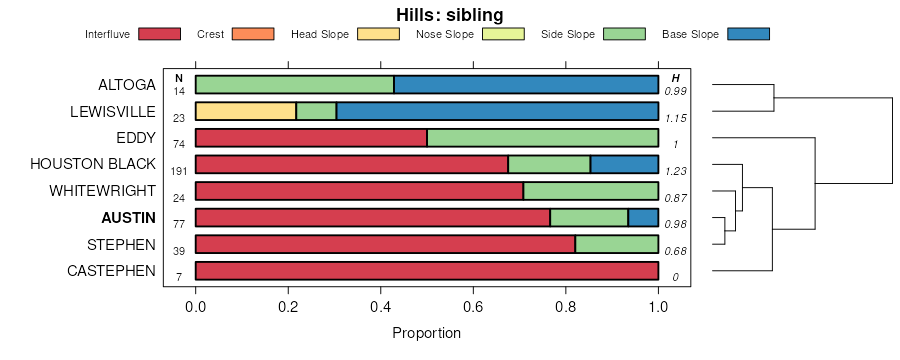
| Austin silty clay, 1 to 3 percent slopes | AsB | 19143 | 391066 | 2vtgj | tx027 | 1972 | 1:24000 |
Austin silty clay, 2 to 5 percent slopes, moderately eroded | AsC | 18913 | 391067 | 2vtgk | tx027 | 1972 | 1:24000 |
Austin-Urban land complex, 2 to 5 percent slopes | AuC | 3007 | 391068 | 2sshc | tx027 | 1972 | 1:24000 |
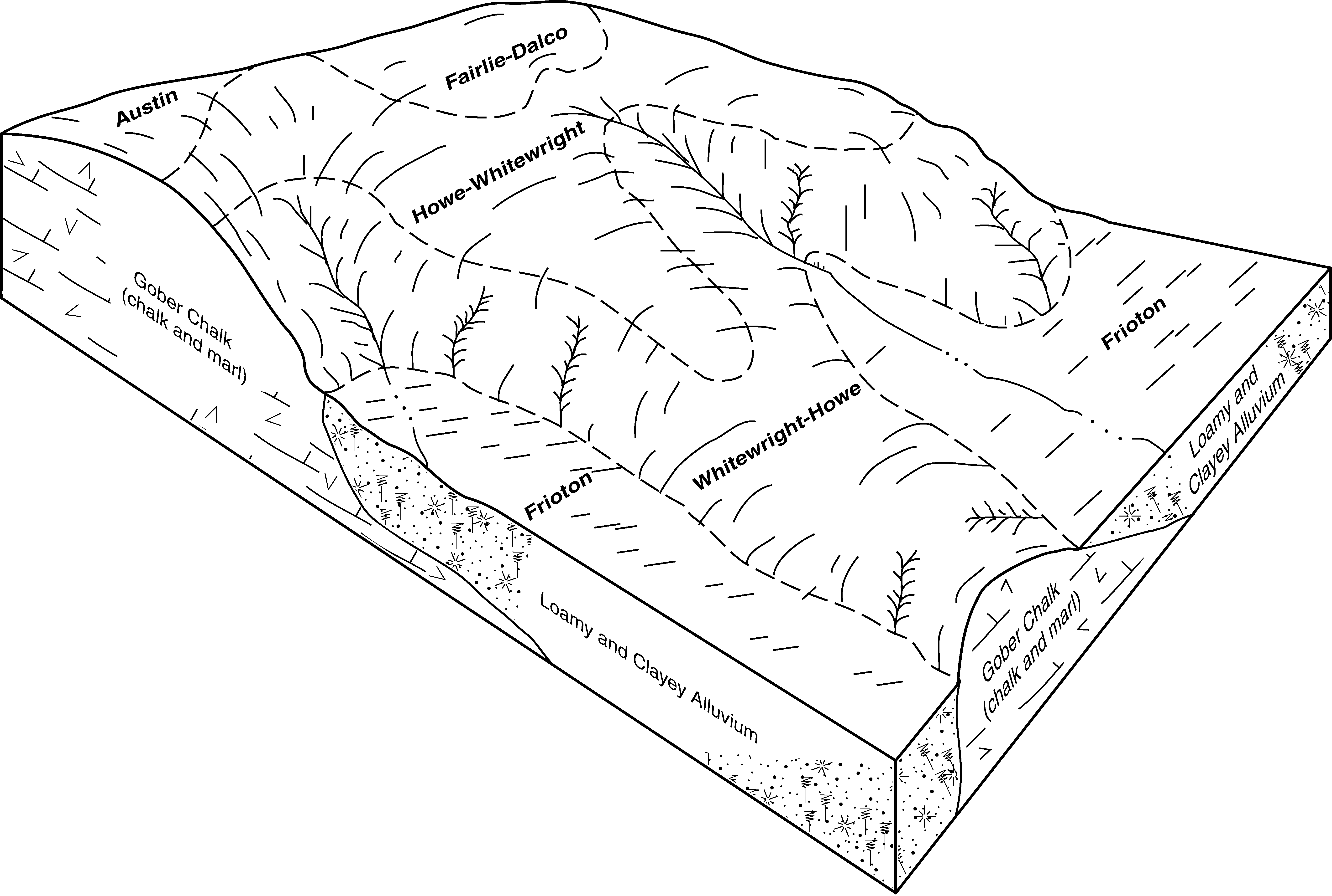
Austin-Whitewright complex, 2 to 6 percent slopes, eroded | AwD3 | 637 | 3130034 | 2s1qt | tx027 | 1972 | 1:24000 |
Austin silty clay, 0 to 1 percent slopes | AsA | 386 | 3130033 | 2s1qs | tx027 | 1972 | 1:24000 |
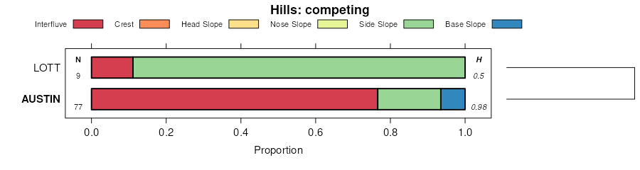
Whitewright-Austin complex, 1 to 5 percent slopes | BsC | 9172 | 390452 | f397 | tx029 | 2000 | 1:24000 |
Austin silty clay, 2 to 5 percent slopes, moderately eroded | AuC | 8480 | 390448 | 2vtgk | tx029 | 2000 | 1:24000 |
Austin silty clay, 1 to 3 percent slopes | AuB | 8003 | 390447 | 2vtgj | tx029 | 2000 | 1:24000 |
Austin silty clay, 2 to 5 percent slopes, moderately eroded | AuC2 | 32005 | 364057 | 2vtgk | tx085 | 1965 | 1:20000 |
Austin silty clay, 1 to 3 percent slopes | AuB | 25525 | 364056 | 2vtgj | tx085 | 1965 | 1:20000 |
Austin silty clay, 5 to 8 percent slopes, moderately eroded | AuD2 | 13497 | 364058 | 2vv4v | tx085 | 1965 | 1:20000 |
Austin-Urban land complex, 0 to 2 percent slopes | 8 | 19293 | 364866 | d7nw | tx113 | 1975 | 1:20000 |
Austin silty clay, 1 to 3 percent slopes | 5 | 16432 | 364833 | 2vtgj | tx113 | 1975 | 1:20000 |
Austin-Urban land complex, 2 to 5 percent slopes | 9 | 12700 | 364868 | 2sshc | tx113 | 1975 | 1:20000 |
Austin-Lewisville complex, 5 to 8 percent slopes, erode d | 7 | 3965 | 364855 | d7nj | tx113 | 1975 | 1:20000 |
Austin silty clay, 2 to 5 percent slopes, moderately eroded | 6 | 3871 | 364844 | 2vtgk | tx113 | 1975 | 1:20000 |
Austin silty clay, 1 to 3 percent slopes | AuB | 42644 | 365275 | 2vtgj | tx139 | 1962 | 1:20000 |
Austin silty clay, 2 to 5 percent slopes, moderately eroded | AuC2 | 15230 | 365276 | 2vtgk | tx139 | 1962 | 1:20000 |
Austin silty clay, 5 to 8 percent slopes, moderately eroded | AuD2 | 2956 | 365277 | 2vv4v | tx139 | 1962 | 1:20000 |
Whitewright and Austin soils, 2 to 5 percent slopes eroded | BkC2 | 742 | 365280 | d837 | tx139 | 1962 | 1:20000 |
Austin silty clay, 1 to 3 percent slopes | 5 | 1822 | 365470 | 2vtgj | tx145 | 1975 | 1:20000 |
Austin silty clay, 2 to 5 percent slopes, moderately eroded | 6 | 1645 | 365481 | 2vtgk | tx145 | 1975 | 1:20000 |
Austin silty clay loam, 1 to 3 percent slopes | AuB | 6130 | 365497 | d8b7 | tx147 | 1989 | 1:24000 |
Austin silty clay, 2 to 5 percent slopes, moderately eroded | 9 | 16142 | 366723 | 2vtgk | tx181 | 1977 | 1:20000 |
Austin silty clay, 1 to 3 percent slopes | 8 | 12894 | 366720 | 2vtgj | tx181 | 1977 | 1:20000 |
Austin-Urban land complex, 2 to 5 percent slopes | 10 | 1858 | 366644 | 2sshc | tx181 | 1977 | 1:20000 |
Austin silty clay, 1 to 3 percent slopes | AuB | 1985 | 366835 | 2vtgj | tx187 | 1973 | 1:20000 |
Austin silty clay, 2 to 5 percent slopes, moderately eroded | AuC3 | 1881 | 366836 | 2vtgk | tx187 | 1973 | 1:20000 |
Austin silty clay, 1 to 3 percent slopes | 7 | 10360 | 367786 | 2vtgj | tx217 | 1975 | 1:20000 |
Austin silty clay, 2 to 5 percent slopes, moderately eroded | 8 | 5980 | 367797 | 2vtgk | tx217 | 1975 | 1:20000 |
Austin silty clay, 1 to 3 percent slopes | AsB | 7832 | 370072 | 2vtgj | tx309 | 1992 | 1:24000 |
Austin-Urban land complex, 1 to 3 percent slopes | AuC | 5141 | 370073 | df2v | tx309 | 1992 | 1:24000 |
Austin silty clay, 1 to 5 percent slopes | AuC | 1428 | 370535 | 2vv4s | tx325 | 1972 | 1:24000 |
Austin silty clay, 1 to 3 percent slopes | AuB | 6137 | 371427 | dghj | tx387 | 1972 | 1:24000 |
Urban land, Austin, and Whitewright soils, 1 to 8 percent slopes | UtD | 9910 | 393255 | f66n | tx453 | 1969 | 1:20000 |
Austin-Urban land complex, 2 to 5 percent slopes | UsC | 8031 | 393254 | 2sshc | tx453 | 1969 | 1:20000 |
Austin silty clay, 2 to 5 percent slopes, moderately eroded | AsC2 | 7414 | 392158 | 2vtgk | tx453 | 1969 | 1:20000 |
Austin silty clay, 1 to 3 percent slopes | AsB | 6415 | 392157 | 2vtgj | tx453 | 1969 | 1:20000 |
Austin-Whitewright complex, 3 to 5 percent slopes, moderately eroded | AtC2 | 3300 | 392159 | f529 | tx453 | 1969 | 1:20000 |
Austin-Whitewright complex, 5 to 8 percent slopes, moderately eroded | AtD2 | 1198 | 392160 | f52b | tx453 | 1969 | 1:20000 |
Austin silty clay, 1 to 3 percent slopes | AsB | 25716 | 373518 | 2vtgj | tx491 | 1981 | 1:20000 |
Austin-Whitewright complex, 2 to 6 percent slopes, eroded | AwD3 | 18941 | 373519 | 2s1qt | tx491 | 1981 | 1:20000 |
Austin silty clay, 0 to 1 percent slopes | AsA | 844 | 373517 | 2s1qs | tx491 | 1981 | 1:20000 |
Austin-Castephen complex, 1 to 3 percent slopes | AuB | 2924 | 378702 | dq26 | tx604 | 1981 | 1:20000 |
Austin-Castephen complex, 2 to 5 percent slopes, eroded | AuC3 | 696 | 378703 | dq27 | tx604 | 1981 | 1:20000 |
Austin silty clay, 1 to 3 percent slopes | 4 | 6448 | 393334 | f696 | tx614 | 1975 | 1:20000 |


