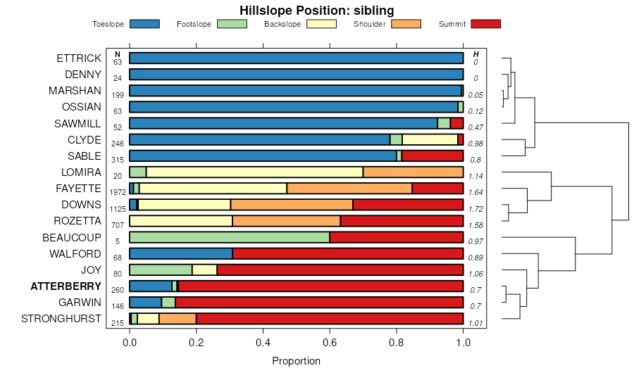
| Atterberry silt loam, 1 to 3 percent slopes | 291 | 253 | 402429 | fhrl | ia005 | 1992 | 1:15840 |
Atterberry silt loam, terrace, 0 to 2 percent slopes | 1291 | 691 | 402824 | 2yvk8 | ia011 | 1977 | 1:15840 |
Atterberry silt loam, 1 to 3 percent slopes | 291 | 572 | 402867 | 2yvk2 | ia011 | 1977 | 1:15840 |
Atterberry silt loam, 1 to 3 percent slopes | 291 | 8830 | 1397099 | 2yvk2 | ia031 | 2008 | 1:12000 |
Atterberry silt loam, 2 to 5 percent slopes | 291B | 2177 | 1397100 | 2yvk6 | ia031 | 2008 | 1:12000 |
Atterberry silt loam, terrace, 0 to 2 percent slopes | 1291 | 1971 | 1397068 | 2yvk8 | ia031 | 2008 | 1:12000 |
Atterberry silt loam, 1 to 3 percent slopes | 291 | 532 | 404251 | fknc | ia043 | 1979 | 1:15840 |
Atterberry silt loam, sandy substratum, 0 to 2 percent slopes | 351 | 9352 | 404406 | 2yvk3 | ia045 | 1978 | 1:15840 |
Atterberry silt loam, benches, 1 to 3 percent slopes | 1291 | 3378 | 404344 | fkrc | ia045 | 1978 | 1:15840 |
Atterberry silt loam, 1 to 3 percent slopes | 291 | 3173 | 404400 | fkt5 | ia045 | 1978 | 1:15840 |
Atterberry silt loam, 1 to 3 percent slopes | 291 | 364 | 405239 | 2yvk2 | ia057 | 1980 | 1:15840 |
Atterberry silt loam, 1 to 3 percent slopes | 291 | 494 | 405415 | flvx | ia061 | 1983 | 1:15840 |
Atterberry silt loam, 1 to 3 percent slopes | 291 | 518 | 406654 | 2yvk2 | ia083 | 1982 | 1:15840 |
Atterberry silt loam, terrace, 0 to 2 percent slopes | 1291 | 660 | 1144375 | 2yvk8 | ia095 | 2005 | 1:12000 |
Atterberry silt loam, 1 to 3 percent slopes | 291 | 419 | 452846 | 2yvk2 | ia095 | 2005 | 1:12000 |
Atterberry silt loam, benches, 0 to 2 percent slopes | 1291 | 1273 | 407449 | fnzj | ia097 | 1988 | 1:15840 |
Atterberry silt loam, 2 to 5 percent slopes | 291B | 384 | 407486 | fp0q | ia097 | 1988 | 1:15840 |
Atterberry silt loam, 1 to 3 percent slopes | 291 | 509 | 407654 | 2yvk2 | ia099 | 1975 | 1:15840 |
Atterberry silt loam, 1 to 3 percent slopes | 291 | 2992 | 407991 | 2yvk2 | ia103 | 1979 | 1:15840 |
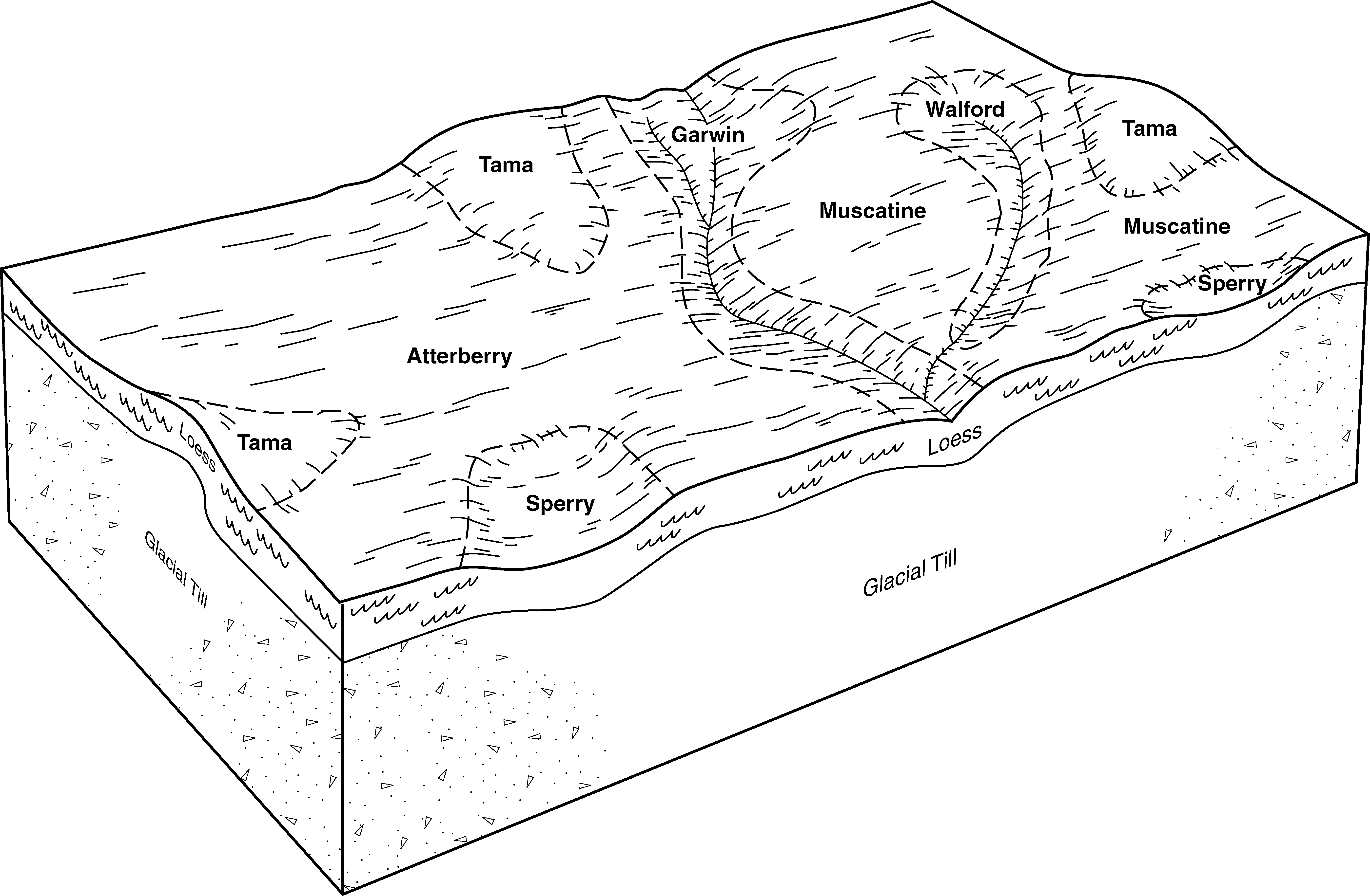
Walford-Atterberry silt loams, 1 to 3 percent slopes | 161 | 1097 | 407950 | 2yvk4 | ia103 | 1979 | 1:15840 |
Atterberry silt loam, 2 to 5 percent slopes | 291B | 291 | 407992 | 2yvk6 | ia103 | 1979 | 1:15840 |
Atterberry silt loam, terrace, 0 to 2 percent slopes | 1291 | 266 | 407938 | 2yvk8 | ia103 | 1979 | 1:15840 |
Atterberry silt loam, 2 to 5 percent slopes | 291B | 2046 | 408134 | 2yvk6 | ia105 | 1988 | 1:15840 |
Atterberry silt loam, sandy substratum, 0 to 2 percent slopes | 351 | 1064 | 408142 | 2yvk3 | ia105 | 1988 | 1:15840 |
Atterberry silt loam, terrace, 0 to 2 percent slopes | 1291 | 967 | 408084 | 2yvk8 | ia105 | 1988 | 1:15840 |
Atterberry silt loam, terrace, 2 to 5 percent slopes | 1291B | 682 | 408085 | 2yvk7 | ia105 | 1988 | 1:15840 |
Atterberry silt loam, 0 to 2 percent slopes | 291 | 253 | 408456 | fq10 | ia111 | 1976 | 1:15840 |
Atterberry silt loam, sandy substratum, 0 to 2 percent slopes | 351A | 3421 | 408612 | 2yvk3 | ia113 | 1970 | 1:15840 |
Atterberry silt loam, terrace, 0 to 2 percent slopes | T291A | 1731 | 408701 | 2yvk8 | ia113 | 1970 | 1:15840 |
Atterberry silt loam, 1 to 3 percent slopes | 291A | 1433 | 408599 | 2yvk2 | ia113 | 1970 | 1:15840 |
Atterberry silt loam, 2 to 5 percent slopes | 291B | 433 | 408600 | 2yvk6 | ia113 | 1970 | 1:15840 |
Atterberry silt loam, terrace, 2 to 5 percent slopes | 1291B | 2 | 2606443 | 2qcs9 | ia113 | 1970 | 1:15840 |
Atterberry silt loam, 1 to 3 percent slopes | 291 | 5276 | 408758 | 2yvk2 | ia115 | 1984 | 1:15840 |
Atterberry silt loam, 1 to 3 percent slopes | 291 | 627 | 409661 | 2yvk2 | ia131 | 1971 | 1:15840 |
Atterberry silt loam, 1 to 3 percent slopes | 291 | 8430 | 409961 | 2yvk2 | ia139 | 1986 | 1:15840 |
Atterberry silt loam, 2 to 5 percent slopes | 291B | 3025 | 409962 | 2yvk6 | ia139 | 1986 | 1:15840 |
Atterberry silt loam, 1 to 3 percent slopes | 291 | 253 | 410578 | 2yvk2 | ia157 | 1978 | 1:15840 |
Atterberry silt loam, 1 to 3 percent slopes | 291 | 1766 | 410953 | 2yvk2 | ia163 | 1989 | 1:15840 |
Atterberry-Urban land complex, 0 to 2 percent slopes | 4291 | 740 | 410995 | fsnx | ia163 | 1989 | 1:15840 |
Atterberry silt loam, 1 to 3 percent slopes | 291 | 269 | 411441 | 2yvk2 | ia171 | 1989 | 1:15840 |
Atterberry silt loam, 1 to 4 percent slopes | 291B | 531 | 437163 | gnx1 | ia191 | 2005 | 1:12000 |
Atterberry silt loam, 0 to 2 percent slopes | 61A | 2882 | 1015757 | 132zc | il007 | 2006 | 1:12000 |
Atterberry silt loam, terrace, 0 to 2 percent slopes | 9061A | 39 | 1483304 | 1lshj | il007 | 2006 | 1:12000 |
Atterberry silt loam, 0 to 2 percent slopes | 61A | 284 | 172992 | 5t0d | il009 | 1984 | 1:12000 |
Atterberry silt loam, 0 to 2 percent slopes | 61A | 2524 | 1862667 | 20j81 | il011 | 2007 | 1:12000 |
Atterberry silt loam, 0 to 2 percent slopes | 61A | 1418 | 796006 | vq9m | il015 | 2005 | 1:12000 |
Atterberry silt loam, 2 to 5 percent slopes | 61B | 532 | 796007 | vq9n | il015 | 2005 | 1:12000 |
Atterberry silt loam, 0 to 2 percent slopes | 61A | 14395 | 2542221 | 2qxqt | il061 | 1968 | 1:15840 |
Atterberry silt loam, 2 to 5 percent slopes, eroded | 61B2 | 4305 | 175208 | 5w9w | il067 | 1993 | 1:15840 |
Atterberry silt loam, 0 to 2 percent slopes | 61A | 4164 | 175207 | 5w9v | il067 | 1993 | 1:15840 |
Atterberry silt loam, 2 to 5 percent slopes | 61B | 440 | 2604056 | 2r772 | il067 | 1993 | 1:15840 |
Atterberry silt loam, 0 to 2 percent slopes | 61A | 889 | 263041 | 8tq6 | il071 | 2005 | 1:12000 |
Atterberry silt loam, 2 to 5 percent slopes | 61B | 257 | 1412359 | 1jdnz | il071 | 2005 | 1:12000 |
Atterberry silt loam, 0 to 2 percent slopes | 61A | 3067 | 729098 | sgp9 | il083 | 2002 | 1:12000 |
Atterberry silt loam, 2 to 5 percent slopes | 61B | 2983 | 1949630 | 23fr9 | il085 | 1990 | 1:12000 |
Atterberry silt loam, 2 to 5 percent slopes | 61B | 3104 | 1415640 | 1jj2t | il099 | 2006 | 1:12000 |
Atterberry silt loam, 0 to 2 percent slopes | 61A | 2835 | 263557 | 8v7v | il099 | 2006 | 1:12000 |
Atterberry silt loam, 0 to 2 percent slopes | 61A | 464 | 634192 | p8xt | il109 | 2002 | 1:12000 |
Atterberry silt loam, 0 to 2 percent slopes | 61A | 985 | 199062 | 6p4c | il113 | 2000 | 1:12000 |
Atterberry silt loam, 0 to 2 percent slopes | 61A | 5978 | 244949 | 86wl | il131 | 2000 | 1:12000 |
Atterberry silt loam, terrace, 0 to 2 percent slopes | 9061A | 344 | 245033 | 86z9 | il131 | 2000 | 1:12000 |
Atterberry silt loam, 0 to 2 percent slopes | 61A | 1484 | 1144333 | 17drz | il141 | 2005 | 1:12000 |
Atterberry silt loam, 0 to 2 percent slopes | 61A | 2900 | 198744 | 6nt3 | il161 | 2002 | 1:12000 |
Atterberry silt loam, 0 to 2 percent slopes | 61A | 1804 | 179300 | 60kw | il177 | 2006 | 1:12000 |
Atterberry silt loam, 2 to 5 percent slopes | 61B | 761 | 1591905 | 1qfhs | il177 | 2006 | 1:12000 |
Atterberry silt loam, 0 to 2 percent slopes | 61A | 3064 | 179418 | 60pp | il179 | 1991 | 1:15840 |
Atterberry silt loam, 0 to 2 percent slopes | 61A | 491 | 244912 | 86vd | il187 | 2002 | 1:12000 |
Atterberry silt loam, 0 to 2 percent slopes | 61A | 380 | 793022 | vm6c | il195 | 2003 | 1:12000 |
Atterberry silt loam, 0 to 2 percent slopes | 61A | 3043 | 173918 | 5tz8 | il201 | 1997 | 1:12000 |
Atterberry silt loam, terrace, 0 to 2 percent slopes | 9061A | 1183 | 174228 | 5v98 | il201 | 1997 | 1:12000 |
Atterberry silt loam, 0 to 2 percent slopes | 61A | 1592 | 869242 | y5j2 | il203 | 2008 | 1:12000 |
Atterberry silt loam, 2 to 6 percent slopes | 138B | 3744 | 423247 | g6f4 | wi021 | 1972 | 1:15840 |
Atterberry silt loam, 0 to 2 percent slopes | 138A | 2684 | 423246 | g6f3 | wi021 | 1972 | 1:15840 |
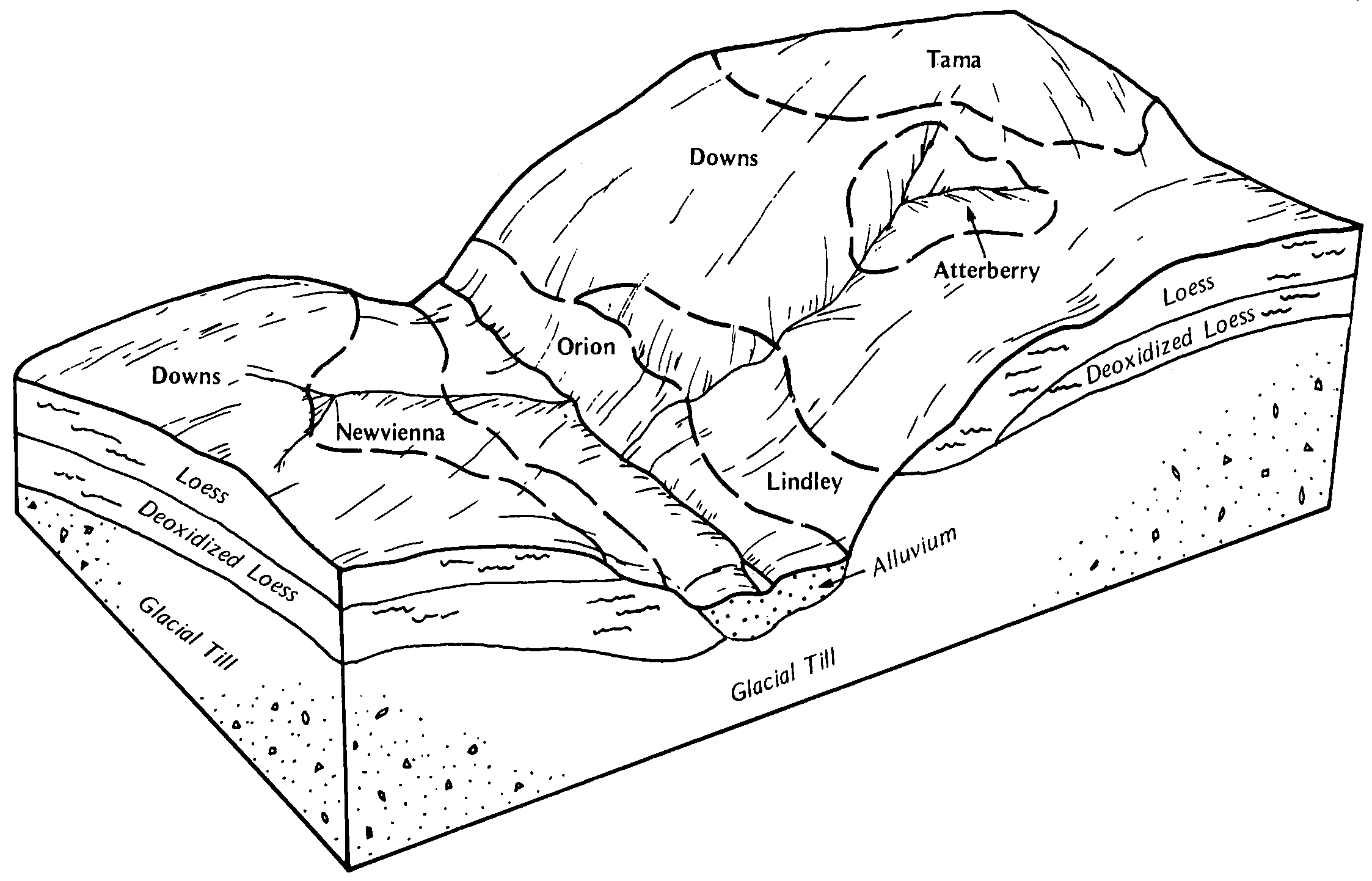
Atterberry-Downs silt loams, 6 to 15 percent slopes, moderately eroded | 1138C2 | 1209 | 424137 | g7bv | wi043 | 1959 | 1:20000 |
Atterberry silt loam, 0 to 2 percent slopes | 138A | 259 | 424135 | g7bs | wi043 | 1959 | 1:20000 |
Atterberry silt loam, 2 to 6 percent slopes | 138B | 243 | 424136 | g7bt | wi043 | 1959 | 1:20000 |
Atterberry silt loam, 2 to 6 percent slopes | 138B | 1293 | 423116 | g68x | wi111 | 1977 | 1:15840 |
Atterberry silt loam, 0 to 2 percent slopes | 138A | 178 | 423115 | g68w | wi111 | 1977 | 1:15840 |
Atterberry silt loam, 0 to 3 percent slopes | 138A | 1387 | 422766 | g5xm | wi139 | 1977 | 1:20000 |
