Official Series Description


Lab Data Summary

Aggregate lab data for the ATKINS soil series. This aggregation is based on all pedons with a current taxon name of ATKINS, and applied along 1-cm thick depth slices. Solid lines are the slice-wise median, bounded on either side by the interval defined by the slice-wise 5th and 95th percentiles. The median is the value that splits the data in half. Five percent of the data are less than the 5th percentile, and five percent of the data are greater than the 95th percentile. Values along the right hand side y-axis describe the proportion of pedon data that contribute to aggregate values at this depth. For example, a value of "90%" at 25cm means that 90% of the pedons correlated to ATKINS were used in the calculation. Source: KSSL snapshot . Methods used to assemble the KSSL snapshot used by SoilWeb / SDE

Click the image to view it full size.

Pedons used in the lab summary:

MLRALab IDPedon IDTaxonnameCINSSL / NASIS ReportsLink To SoilWeb GMap
12459PA0630041959PA063004Atkins3Primary | Supplementary | Taxonomy | Pedon | Water Retention | Correlation | Andic Soil Properties40.7888889,-79.0558333
12703N0673S2002PA031008Atkins6Primary | Supplementary | Taxonomy | Pedon | Water Retention | Correlation | Andic Soil Properties41.2733611,-79.4745
14774PA1070271974PA107027Atkins3Primary | Supplementary | Taxonomy | Pedon | Water Retention | Correlation | Andic Soil Properties40.5852778,-76.2933333
14788PA1070551988PA107055Atkins4Primary | Supplementary | Taxonomy | Pedon | Water Retention | Correlation | Andic Soil Properties40.5452778,-76.2502778
14700P054999MD001002Atkins7Primary | Supplementary | Taxonomy | Pedon | Water Retention | Correlation | Andic Soil Properties39.5224991,-78.5666656
n/aHO-0011953-OH073-001Atkins3Primary | Supplementary | Taxonomy | Pedon | Water Retention | Correlation | Andic Soil Propertiesn/a
n/aCO-1221959-OH029-122Atkins3Primary | Supplementary | Taxonomy | Pedon | Water Retention | Correlation | Andic Soil Propertiesn/a
n/a99KY-011-00199KY-011-001Atkins1Primary | Supplementary | Taxonomy | Pedon | Water Retention | Correlation | Andic Soil Propertiesn/a

Water Balance

Monthly water balance estimated using a leaky-bucket style model for the ATKINS soil series. Monthly precipitation (PPT) and potential evapotranspiration (PET) have been estimated from the 50th percentile of gridded values (PRISM 1981-2010) overlapping with the extent of SSURGO map units containing each series as a major component. Monthly PET values were estimated using the method of Thornthwaite (1948). These (and other) climatic parameters are calculated with each SSURGO refresh and provided by the fetchOSD function of the soilDB package. Representative water storage values (“AWC” in the figures) were derived from SSURGO by taking the 50th percentile of profile-total water storage (sum[awc_r * horizon thickness]) for each soil series. Note that this representation of “water storage” is based on the average ability of most plants to extract soil water between 15 bar (“permanent wilting point”) and 1/3 bar (“field capacity”) matric potential. Soil moisture state can be roughly interpreted as “dry” when storage is depleted, “moist” when storage is between 0mm and AWC, and “wet” when there is a surplus. Clearly there are a lot of assumptions baked into this kind of monthly water balance. This is still a work in progress.

Click the image to view it full size.


Click the image to view it full size.

Sibling Summary

Siblings are those soil series that occur together in map units, in this case with the ATKINS series. Sketches are arranged according to their subgroup-level taxonomic structure. Source: SSURGO snapshot , parsed OSD records and snapshot of SC database .

Click the image to view it full size.

Select annual climate data summaries for the ATKINS series and siblings. Series are sorted according to hierarchical clustering of median values. Source: SSURGO map unit geometry and 1981-2010, 800m PRISM data .

Click the image to view it full size.

Geomorphic description summaries for the ATKINS series and siblings. Series are sorted according to hierarchical clustering of proportions and relative hydrologic position within an idealized landform (e.g. top to bottom). Most soil series (SSURGO components) are associated with a hillslope position and one or more landform-specific positions: hills, mountain slopes, terraces, and/or flats. Proportions can be interpreted as an aggregate representation of geomorphic membership. The values printed to the left (number of component records) and right (Shannon entropy) of stacked bars can be used to judge the reliability of trends. Small Shannon entropy values suggest relatively consistent geomorphic association, while larger values suggest lack thereof. Source: SSURGO component records .

Click the image to view it full size.

Click the image to view it full size.

Click the image to view it full size.

Click the image to view it full size.

Click the image to view it full size.

Competing Series

Soil series competing with ATKINS share the same family level classification in Soil Taxonomy. Source: parsed OSD records and snapshot of the SC database .

Click the image to view it full size.

Select annual climate data summaries for the ATKINS series and competing. Series are sorted according to hierarchical clustering of median values. Source: SSURGO map unit geometry and 1981-2010, 800m PRISM data .

Click the image to view it full size.

Geomorphic description summaries for the ATKINS series and competing. Series are sorted according to hierarchical clustering of proportions and relative hydrologic position within an idealized landform (e.g. top to bottom). Proportions can be interpreted as an aggregate representation of geomorphic membership. Most soil series (SSURGO components) are associated with a hillslope position and one or more landform-specific positions: hills, mountain slopes, terraces, and/or flats. The values printed to the left (number of component records) and right (Shannon entropy) of stacked bars can be used to judge the reliability of trends. Shannon entropy values close to 0 represent soil series with relatively consistent geomorphic association, while values close to 1 suggest lack thereof. Source: SSURGO component records .

There are insufficient data to create the 2D hillslope position figure.

There are insufficient data to create the 3D hills figure.

There are insufficient data to create the 3D mountains figure.

There are insufficient data to create the 3D terrace figure.

There are insufficient data to create the 3D flats position figure.

Soil series sharing subgroup-level classification with ATKINS, arranged according to family differentiae. Hovering over a series name will print full classification and a small sketch from the OSD. Source: snapshot of SC database .

Block Diagrams

Click a link below to display the diagram. Note that these diagrams may be from multiple survey areas.

  1. KY-2012-01-26-19 | Bath County - September 1963

    Typical landscape in a river valley and the relative position of the principal soils (Soil Survey of Bath County, Kentucky; September 1963).

  2. KY-2012-01-26-25 | Bath County - September 1963

    Cross section of Bath County showing the major soils and their relationship to the rock formations and to relief (Soil Survey of Bath County, Kentucky; September 1963).

  3. KY-2012-02-01-16 | McCreary-Whitley Area - 1970

    General location of the Atkins, Pope, and Tate soils on flood plains and stream terraces in association 1 (Soil Survey of McCreary-Whitley Area, Kentucky; 1970).

  4. MD-2010-09-07-12 | Washington County - 2003

    Relationship of soils to topography and underlying material in the Weikert-Berks-Clearbrook general soil map unit (Soil Survey of Washington County, Maryland; 2003).

  5. MD-2012-02-03-27 | Washington County - 2003

    Relationship of soils to topography and underlying material in the Weikert-Berks-Clearbrook general soil map unit (Soil Survey of Washington County, Maryland; 2003).

  6. PA-2010-09-30-07 | Clinton County - 2007

    Typical pattern of soils and parent material on the side slopes and footslopes of the Appalachian Mountain Section (Soil Survey of Clinton County, Pennsylvania; 2007).

  7. PA-2012-03-12-02 | Allegheny County - August 1981

    Relationship of soils to geology and physiography in soil association 5 (Soil Survey of Allegheny County, PA; 1981).

  8. PA-2012-03-12-06 | Beaver and Lawrence Counties - April 1982

    Pattern of soils and parent material in Gilpin-Wharton-Weikert association (Soil Survey of Beaver and Lawrence Counties, PA; 1982).

  9. PA-2012-03-12-08 | Beaver and Lawrence Counties - April 1982

    Pattern of soils and parent material in Gilpin-Guernsey-Culleoka association (Soil Survey of Beaver and Lawrence Counties, PA; 1982).

  10. PA-2012-03-12-09 | Beaver and Lawrence Counties - April 1982

    Pattern of soils and parent material in Gilpin-Weikert association (Soil Survey of Beaver and Lawrence Counties, PA; 1982).

  11. PA-2012-03-12-12 | Bedford County - 1998

    Typical pattern of soils and parent material in the Berks-Weikert-Blairton general soil map unit (Soil Survey of Bedford County, PA; 1998).

  12. PA-2012-03-12-15 | Berks County - September 1970

    Cross section of the northern part of Berks County showing soils of associations 1, 2, and 3 (Soil Survey of berks County, PA; 1970).

  13. PA-2012-03-13-02 | Cambria County - September 1985

    Typical pattern of soils and parent material in the Gilpin-Ernest-Wharton association (Soil Survey of Cambria County, PA; 1985).

  14. PA-2012-03-13-03 | Cambria County - September 1985

    Typical pattern of soils and parent material in the Brinkerton-Wharton-Cavode association (Soil Survey of Cambria County, PA; 1985).

  15. PA-2012-03-13-04 | Cameron and Elk Counties - February 1993

    Typical pattern of soils and underlying material in the Hazleton-Buchanan-Cookport association (Soil Survey of Cameron and Elk Counties, PA; 1993).

  16. PA-2012-03-13-05 | Cameron and Elk Counties - February 1993

    Typical pattern of soils and underlying material in the Hazleton-Cookport-Buchanan association (Soil Survey of Cameron and Elk Counties, PA; 1993).

  17. PA-2012-03-13-11 | Centre County - August 1981

    Typical pattern of soils and underlying material in association 10 (Soil Survey of Centre County, PA; 1981).

  18. PA-2012-03-13-16 | Clearfield County - August 1988

    Typical pattern of soils and underlying material in the Atkins-Philo-Monongahela association (Soil Survey of Clearfield County, PA; 1988).

  19. PA-2012-03-13-17 | Cumberland and Perry Counties - April 1986

    Typical pattern of soils and underlying material in the Berks-Weikert-Bedington association (Soil Survey of Cumberland and Perry Counties, PA; 1986).

  20. PA-2012-03-13-19 | Cumberland and Perry Counties - April 1986

    Typical pattern of soils and underlying material in the Hazleton-Laidig-Buchanan association (Soil Survey of Cumberland and Perry Counties, PA; 1986).

  21. PA-2012-03-13-20 | Cumberland and Perry Counties - April 1986

    Typical pattern of soils and underlying material in the Murrill-Laidig-Buchanan association (Soil Survey of Cumberland and Perry Counties, PA; 1986).

  22. PA-2012-03-13-21 | Cumberland and Perry Counties - April 1986

    Typical pattern of soils and underlying material in the Hazleton-Clymer association (Soil Survey of Cumberland and Perry Counties, PA; 1986).

  23. PA-2012-03-13-25 | Fayette County - March 1973

    Parent material, position, and pattern of soils in the Monongahela-Philo-Atkins soil association (Soil Survey of Fayette County, PA; 1973).

  24. PA-2012-03-13-30 | Franklin County - August 1975

    Relationship of underlying material and topography in association 5 (Soil Survey of Franklin County, PA; 1975).

  25. PA-2012-03-13-36 | Indiana County - January 1968

    Parent material, position, and pattern of soils in the Gilpin-Wharton-Upshur association (Soil Survey of Indiana County, PA; 1968).

  26. PA-2012-03-13-61 | McKean County - August 1987

    Typical landscape pattern of the soils and the underlying material in the Buchanan-Hartleton-Leck Kill general soil map unit (Soil Survey of McKean County, PA; 1987).

  27. PA-2012-03-14-12 | Somerset County - December 1983

    Typical pattern of soils and underlying material in area of Rayne-Gilpin-Wharton-Cavode soils (Soil Survey of Somerset County, PA; 1983).

  28. PA-2012-03-14-14 | Somerset County - December 1983

    Typical pattern of soils and underlying material in area of Berks-Weikert soils (Soil Survey of Somerset County, PA; 1983).

  29. PA-2012-03-14-15 | Somerset County - December 1983

    Typical pattern of soils and underlying material in area of Leck Kill-Albrights soils (Soil Survey of Somerset County, PA; 1983).

  30. PA-2012-03-14-16 | Somerset County - December 1983

    Typical pattern of soils and underlying material in area of Ernest-Rayne-Gilpin soils (Soil Survey of Somerset County, PA; 1983).

  31. PA-2012-03-14-26 | Venango County - December 1975

    Pattern of soils and underlying material in Alton-Monongahela-Philo association (Soil Survey of Venango County, PA; 1975).

  32. PA-2012-03-14-27 | Venango County - December 1975

    Pattern of soils and underlying material in Hanover-Alvira association (Soil Survey of Venango County, PA; 1975).

  33. PA-2012-03-14-29 | Venango County - December 1975

    Pattern of soils and underlying material in Cavode-Wharton association (Soil Survey of Venango County, PA; 1975).

  34. VA-2010-11-05-02 | Bland County -

    Diagram of a sequence of landforms along Walker Creek in Bland County. The soils named on the land surface are shown in their natural relationship to each other and in their relationship to landform position (Soil Survey of Bland County, Virginia).

  35. VA-2010-11-05-03 | Bland County -

    Diagram of a sequence of landforms along Wolf Creek in Bland County. The soils named on the land surface are shown in their natural relationship to each other and in their relationship to landform position (Soil Survey of Bland County, Virginia).

Map Units

Map units containing ATKINS as a major component. Limited to 250 records.

Map Unit Name Symbol Map Unit Area (ac) Map Unit Key National Map Unit Symbol Soil Survey Area Publication Date Map Scale
Atkins and Stendal soils, local alluvium, 0 to 2 percent slopesAsA7651523288kkj8al01519591:20000
Atkins silt loam, 0 to 2 percent slopesAkA3488523287kkj7al01519591:20000
Atkins silt loam, local alluviumAt9901328890c17cal04319601:20000
Atkins silt loamAu6000329127c1h0al04919531:20000
Atkins soils, local alluviumAt437329444c1t7al05719631:15840
Philo-Atkins silt loamsPA8208522940kk51al07119431:24000
Atkins silt loamAl3831330079c2gqal07919501:20000
Atkins soilsAk333330668c32qal09519561:20000
Atkins silt loamAo6117331031c3gfal10319491:15840
Atkins silt loamAk6621626485g7qin15319661:15840
Atkins-Stokly complex, 0 to 3 percent slopes, frequently flooded303714612219nk20ky63019661:15840
Atkins silt loam, 0 to 3 percent slopes, frequently floodedAtA55924010302llglmd00120091:12000
Atkins silt loam, 0 to 3 percent slopes, frequently floodedAt58905328902sfspmd02319701:20000
Atkins silt loamAt1228534131kxt1md04319981:12000
Atkins loam, 0 to 3 percent slopes, frequently flooded754362035100831912v7fmo06519711:24000
Atkins loam, 1 to 3 percent slopes, frequently flooded7600170324875902phjvmo06519711:24000
Atkins silt loam, 0 to 3 percent slopes, frequently flooded105382980582sfspny00920021:24000
Atkins silt loamAt9892945799wjkny09719761:15840
Atkins silt loam, 0 to 3 percent slopes, frequently floodedAt82145416582t328pa00319731:15840
Atkins-Philo complex, 0 to 2 percent slopes, frequently floodedAtA232416781961tb9cpa00520121:24000
Atkins silt loam, 0 to 3 percent slopes, frequently floodedAt592629002322t328pa00719781:15840
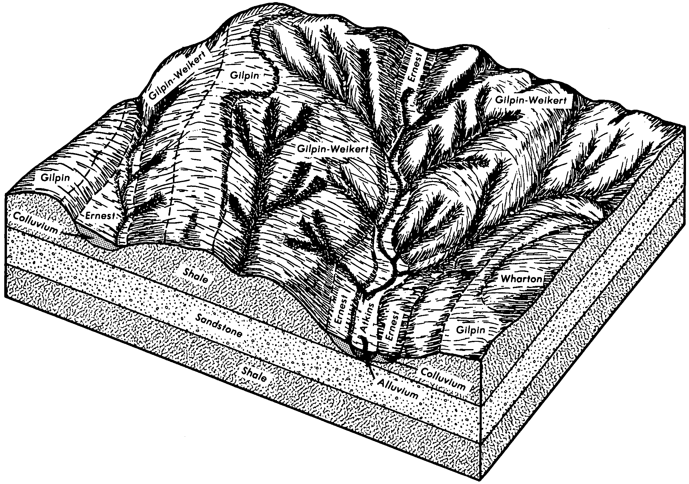
Atkins-Ernest complex, 0 to 8 percent slopesAx5891541757l5r1pa00919891:24000
Atkins silt loamAw3391541756l5r0pa00919891:24000
Atkins silt loam, 0 to 3 percent slopes, frequently floodedAt263455381432t328pa01919841:15840
Atkins silt loam, 0 to 3 percent slopes, frequently floodedAt105625418882sfsppa02119781:20000
Philo and Atkins very stony soilsPk7076538342l25wpa02719751:20000
Atkins silt loam, 0 to 3 percent slopes, frequently floodedAt464131800542sfsppa02719751:20000
Atkins-Philo complex, 0 to 3 percent slopes, frequently floodedAtA47877080312vxh1pa03120121:24000
Atkins silt loam, 0 to 3 percent slopes, frequently floodedAt126085385032sfsppa03319811:20000
Atkins silt loam, 0 to 3 percent slopes, frequently floodedAt37755438812sfsppa03520021:24000
Atkins silt loamAw5468693678r8tqpa04119801:15840
Atkins silt loamAt6318540694l4mrpa04319671:15840
Atkins silt loam, 0 to 3 percent slopes, frequently floodedAt242715910252sfsppa05120051:24000
Atkins silt loamAs5836545064l95qpa05519991:24000
Atkins silt loamAs2975544805l8xcpa05719991:24000
Atkins silt loamAt11928541953l5ycpa06119741:20000
Atkins-Philo complex, 0 to 3 percent slopes, frequently floodedAtA896217208362vxh1pa06320121:24000
Atkins-Philo complex, 0 to 3 percent slopes, frequently floodedAtA964023989232vxh1pa06520121:12000
Atkins silt loam, 0 to 3 percent slopes, frequently floodedAt40829003842t328pa07319781:15840
Atkins silt loamAtg15213976701hxd4pa07519761:20000
Atkins silt loam, 0 to 3 percent slopes, frequently floodedAt95145398822sfsppa08319841:20000
Atkins silt loamAw3073693903r91zpa09919801:15840
Atkins silt loam, 0 to 3 percent slopes, frequently floodedAtA42866078882sfsppa10519531:24000
Atkins silt loamAt8810539698l3lmpa10719771:20000
Atkins silt loam, 0 to 3 percent slopes, frequently floodedAt106685420572sfsppa11119771:20000
Atkins silt loam, 0 to 3 percent slopes, frequently floodedAt77215388992sfsppa12119711:20000
Atkins silt loam, 0 to 3 percent slopes, frequently floodedAt29245446022sfsppa12920031:24000
Atkins silt loamAt6562545455l9lbpa60519751:20000
Atkins silt loam, 0 to 3 percent slopes, frequently floodedAt68625391512sfsppa60719861:20000
Atkins silty clay loamAt1370539209l32vpa60919791:20000
Atkins silt loam, frequently floodedAt11622184602dgh7tn00119781:15840
Atkins silt loam, frequently floodedAt1434524242klj1tn01319931:24000
Atkins silt loamAk546524478klrntn02519481:24000
Prader fine sandy loamPf832524974km8ntn03119561:20000
Atkins loam, frequently floodedAt1796523855kl3ktn03519981:24000
Atkins-Arkaqua complex, frequently floodedAt161526191knjxtn10719991:24000
Atkins silt loamAt622527848kq8ctn12319741:20000
Atkins loam, occasionally floodedAk266843244x9gftn13320031:24000
Atkins loam, frequently floodedAt277728822sgddtn14320031:24000
Atkins silt loamAt751528627kr2htn60419741:20000
Atkins silt loam, frequently floodedAt345632723p7dftn60720031:24000
Atkins silt loamAt105424273932mgx0tn61019601:15840
Atkins silt loam, frequently floodedAt25224390872mw27tn62920031:24000
Atkins-Lily complex, 0 to 20 percent slopes, occasionally floodedAyD11822173192df9ftn65020081:12000
Atkins-Skidmore complex, frequently floodedAz7622173522dfbhtn65020081:12000
Atkins loam, pondedAk4724060482lrpgtn65020081:12000
Atkins fine sandy loam7396518029kd1mva01519781:15840
Atkins silt loam, 0 to 3 percent slopes, occasionally flooded4A61814514151kq9vva01720051:24000
Atkins fine sandy loam, 0 to 3 percent slopes, frequently flooded2A261414026481j2kqva02120051:24000
Atkins loamAt88519179kf7qva03519651:15840
Atkins fine sandy loam, 0 to 3 percent slopes, frequently flooded3A48124810252p8q2va04520101:24000
Atkins silt loam, 0 to 3 percent slopes, occasionally flooded3A58925120212q7v1va09120101:24000
Atkins silt loam, cool, 0 to 3 percent slopes, occasionally flooded4A14725120222q7v2va09120101:24000
Atkins loam, 0 to 3 percent slopes, frequently flooded2A430519357kffgva19119981:15840
Atkins loam, 0 to 3 percent slopes, frequently flooded1145725254322rjwpva6061:24000
Atkins silt loam, 0 to 3 percent slopes, frequently floodedAt47805132172t328wv00119651:12000
Atkins silt loamAt1280516200kb4mwv00319971:24000
Atkins-Philo-Potomac complexAn5725553099lkjxwv02520021:24000
Atkins silt loam, warm, 0 to 3 percent slopes, frequently floodedAt30495144302sfsswv06319621:24000
Atkins silt loamAt1518515355k98cwv07519921:24000
Atkins silt loam, 0 to 3 percent slopes, frequently floodedAt408718626072sfspwv07719551:24000
Atkins silty clay loam, 0 to 3 percent slopes, frequently floodedAv89918626092sfthwv07719551:24000
Philo-Atkins silt loams, moist, 0 to 3 percent slopes, occasionally floodedPa11635154952vxhjwv09719811:20000
Atkins silt loam, moist, 0 to 3 percent slopes, frequently floodedAt7285154532sfsrwv09719811:20000
Atkins loam, moist, 0 to 3 percent slopes, frequently floodedAt3495151082vxgzwv10119921:24000
Atkins silt loam, moist, 0 to 3 percent slopes, frequently floodedAt25345139582sfsrwv60219651:20000
Pope-Atkins complexPn6215515598k9j6wv60319781:20000
Atkins silt loam, moist, 0 to 3 percent slopes, frequently floodedAt50195155092sfsrwv60319781:20000
Atkins silt loam, 0 to 3 percent slopes, frequently floodedAt28216025352t328wv60419701:12000
Atkins silt loamAt3863555859lndywv60819731:20000
Atkins silty clay loamAy504555860lndzwv60819731:20000
Atkins silt loam, 0 to 3 percent slopes, frequently floodedAt7425157722sfspwv61019731:20000
Atkins loam, 0 to 3 percent slopes, frequently floodedAtA8224270962mglfwv62220101:12000
Atkins, coarse, cobbly loamy sand, 0 to 3 percent slopes, very stonyAkAs1832446882zf7gwv62819801:20000
Atkins loam, warm, 0 to 3 percent slopes, frequently floodedAtA550624532002vxh0wv70520091:24000
Atkins silt loamAt17692516575k9xcwv7131:24000

Map of Series Extent

Approximate geographic distribution of the ATKINS soil series. To learn more about how this distribution was mapped, or to compare this soil series extent to others, use the Series Extent Explorer (SEE) application. Source: generalization of SSURGO geometry .