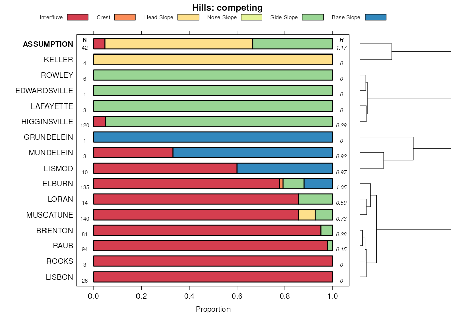
| Assumption silty clay loam, 10 to 18 percent slopes, severely eroded | 259D3 | 876 | 1862728 | 2rmnh | il011 | 2007 | 1:12000 |
Assumption silt loam, 5 to 10 percent slopes, eroded | 259C2 | 3501 | 261697 | 2rmnd | il021 | 1999 | 1:12000 |
Assumption silt loam, 5 to 10 percent slopes, eroded | 259C2 | 512 | 615648 | 2rmnd | il057 | 1997 | 1:12000 |
Assumption silt loam, 5 to 10 percent slopes, eroded | 259C2 | 25 | 211763 | 2rmnd | il061 | 1968 | 1:15840 |
Assumption silt loam, 5 to 10 percent slopes, eroded | 259C2 | 5105 | 175166 | 2rmnd | il067 | 1993 | 1:15840 |
Assumption silt loam, 5 to 10 percent slopes, eroded | 259C2 | 395 | 1481066 | 2rmnd | il071 | 2005 | 1:12000 |
Assumption silt loam, 2 to 5 percent slopes | 259B | 2764 | 244676 | 2rmnb | il073 | 2001 | 1:12000 |
Assumption silt loam, 5 to 10 percent slopes, eroded | 259C2 | 2291 | 244677 | 2rmnd | il073 | 2001 | 1:12000 |
Assumption silt loam, 10 to 18 percent slopes, eroded | 259D2 | 1321 | 244678 | 2rmng | il073 | 2001 | 1:12000 |
Assumption silt loam, 5 to 10 percent slopes, eroded | 259C2 | 615 | 728490 | 2rmnd | il083 | 2002 | 1:12000 |
Assumption silt loam, 5 to 10 percent slopes, eroded | 259C2 | 4069 | 680877 | 2rmnd | il095 | 2002 | 1:12000 |
Assumption silt loam, 10 to 18 percent slopes, eroded | 259D2 | 2940 | 680878 | 2rmng | il095 | 2002 | 1:12000 |
Assumption silty clay loam, 10 to 18 percent slopes, severely eroded | 259D3 | 980 | 680879 | 2rmnh | il095 | 2002 | 1:12000 |
Assumption silt loam, 5 to 10 percent slopes, eroded | 259C2 | 389 | 926881 | 2rmnd | il103 | 2004 | 1:12000 |
Assumption silt loam, 5 to 10 percent slopes, eroded | 259C2 | 1764 | 634196 | 2rmnd | il109 | 2002 | 1:12000 |
Assumption silt loam, 10 to 18 percent slopes, eroded | 259D2 | 289 | 634197 | 2rmng | il109 | 2002 | 1:12000 |
Assumption silt loam, 5 to 10 percent slopes, eroded | 259C2 | 2572 | 199186 | 2rmnd | il117 | 1999 | 1:12000 |
Assumption silt loam, 2 to 5 percent slopes | 259B | 2048 | 199184 | 2rmnb | il117 | 1999 | 1:12000 |
Assumption silt loam, 2 to 5 percent slopes, eroded | 259B2 | 1496 | 199185 | 2rmnc | il117 | 1999 | 1:12000 |
Assumption silt loam, 5 to 10 percent slopes, eroded | 259C2 | 1563 | 244971 | 2rmnd | il131 | 2000 | 1:12000 |
Assumption silt loam, 10 to 18 percent slopes, eroded | 259D2 | 702 | 244972 | 2rmng | il131 | 2000 | 1:12000 |
Assumption silt loam, 5 to 10 percent slopes, eroded | 259C2 | 1610 | 1721397 | 2rmnd | il135 | 2007 | 1:12000 |
Assumption silt loam, 5 to 10 percent slopes, eroded | 259C2 | 3129 | 1672133 | 2rmnd | il137 | 1984 | 1:15840 |
Assumption silt loam, 10 to 18 percent slopes, eroded | 259D2 | 1173 | 1672134 | 2rmng | il137 | 1984 | 1:15840 |
Assumption silt loam, 2 to 5 percent slopes | 259B | 10624 | 208578 | 2rmnb | il141 | 2005 | 1:12000 |
Assumption silt loam, 5 to 10 percent slopes, eroded | 259C2 | 4103 | 208579 | 2rmnd | il141 | 2005 | 1:12000 |
Assumption silt loam, 0 to 2 percent slopes | 259A | 1370 | 208551 | 2ww9r | il141 | 2005 | 1:12000 |
Assumption silt loam, 5 to 10 percent slopes, eroded | 259C2 | 627 | 208975 | 2rmnd | il143 | 1986 | 1:15840 |
Assumption silt loam, 10 to 18 percent slopes, eroded | 259D2 | 325 | 208976 | 2rmng | il143 | 1986 | 1:15840 |
Assumption silt loam, 5 to 10 percent slopes, eroded | 259C2 | 6194 | 199314 | 2rmnd | il167 | 1999 | 1:12000 |
Assumption silt loam, 10 to 18 percent slopes, eroded | 259D2 | 5797 | 199315 | 2rmng | il167 | 1999 | 1:12000 |
Assumption silt loam, 10 to 18 percent slopes, eroded | 259D2 | 83 | 2542073 | 2rmng | il171 | 1984 | 1:12000 |
Assumption silt loam, 10 to 18 percent slopes, eroded | 259D2 | 934 | 179081 | 2rmng | il175 | 1992 | 1:15840 |
Assumption silt loam, 5 to 10 percent slopes, eroded | 259C2 | 577 | 179080 | 2rmnd | il175 | 1992 | 1:15840 |
Assumption silty clay loam, 10 to 18 percent slopes, severely eroded | 259D3 | 420 | 179082 | 2rmnh | il175 | 1992 | 1:15840 |
Assumption silt loam, 5 to 10 percent slopes, eroded | 259C2 | 1100 | 1592073 | 2rmnd | il177 | 2006 | 1:12000 |
Assumption silt loam, 10 to 18 percent slopes, eroded | 259D2 | 4809 | 244880 | 2rmng | il187 | 2002 | 1:12000 |
Assumption silt loam, 5 to 10 percent slopes, eroded | 259C2 | 2795 | 244879 | 2rmnd | il187 | 2002 | 1:12000 |
Assumption silt loam, 2 to 5 percent slopes, eroded | 259B2 | 1034 | 173998 | 2rmnc | il201 | 1997 | 1:12000 |
Assumption silt loam, 5 to 10 percent slopes, eroded | 259C2 | 123 | 173999 | 2rmnd | il201 | 1997 | 1:12000 |