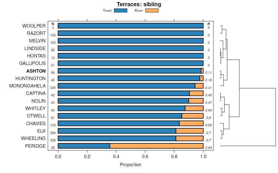
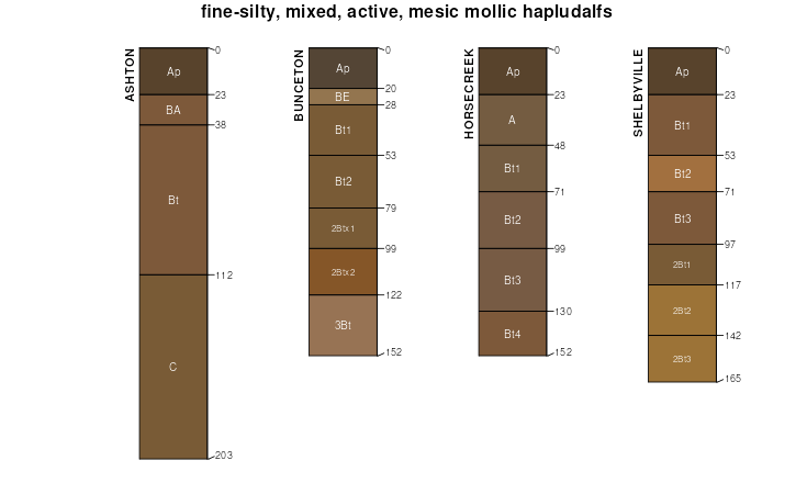
Official Series Description


Lab Data Summary

Aggregate lab data for the ASHTON soil series. This aggregation is based on all pedons with a current taxon name of ASHTON, and applied along 1-cm thick depth slices. Solid lines are the slice-wise median, bounded on either side by the interval defined by the slice-wise 5th and 95th percentiles. The median is the value that splits the data in half. Five percent of the data are less than the 5th percentile, and five percent of the data are greater than the 95th percentile. Values along the right hand side y-axis describe the proportion of pedon data that contribute to aggregate values at this depth. For example, a value of "90%" at 25cm means that 90% of the pedons correlated to ASHTON were used in the calculation. Source: KSSL snapshot . Methods used to assemble the KSSL snapshot used by SoilWeb / SDE

Click the image to view it full size.

Pedons used in the lab summary:

MLRALab IDPedon IDTaxonnameCINSSL / NASIS ReportsLink To SoilWeb GMap
107BM04021022004MO021002ASHTON4Primary | Supplementary | Taxonomy | Pedon | Water Retention | Correlation | Andic Soil Properties39.6261111,-94.7318056
115BM90099011990MO099001Ashton4Primary | Supplementary | Taxonomy | Pedon | Water Retention | Correlation | Andic Soil Properties38.9672644,-92.3451678
115BM90099131990MO099013NAshton4Primary | Supplementary | Taxonomy | Pedon | Water Retention | Correlation | Andic Soil Properties38.4167188,-90.5812213
115BM91057071991MO057007Ashton4Primary | Supplementary | Taxonomy | Pedon | Water Retention | Correlation | Andic Soil Properties38.9672203,-92.3450012
115BM92057881992MO057088Ashton4Primary | Supplementary | Taxonomy | Pedon | Water Retention | Correlation | Andic Soil Properties38.9672203,-92.3450012
115BM93161381993MO161038Ashton4Primary | Supplementary | Taxonomy | Pedon | Water Retention | Correlation | Andic Soil Properties38.9672203,-92.3450012
115BM94099251994MO099231Ashton4Primary | Supplementary | Taxonomy | Pedon | Water Retention | Correlation | Andic Soil Properties38.3925524,-90.5903882
115BM95099021995MO099248Ashton4Primary | Supplementary | Taxonomy | Pedon | Water Retention | Correlation | Andic Soil Properties38.4000523,-90.5709432
115BM95099031995MO099249Ashton4Primary | Supplementary | Taxonomy | Pedon | Water Retention | Correlation | Andic Soil Properties38.3983857,-90.5706654
115CM890072189MO007021Ashton4Primary | Supplementary | Taxonomy | Pedon | Water Retention | Correlation | Andic Soil Properties39.3340556,-91.8773917
116A59ID071959AR06307Ashton3Primary | Supplementary | Taxonomy | Pedon | Water Retention | Correlation | Andic Soil Properties35.8267,-91.7746
116A61ID011961AR06301Ashton3Primary | Supplementary | Taxonomy | Pedon | Water Retention | Correlation | Andic Soil Properties35.8267,-91.7746
116A61ID061961AR06306Ashton3Primary | Supplementary | Taxonomy | Pedon | Water Retention | Correlation | Andic Soil Properties35.8267,-91.7746
116A65BN031965AR00703Ashton3Primary | Supplementary | Taxonomy | Pedon | Water Retention | Correlation | Andic Soil Properties36.1644,-94.4511
116A66BN031966AR00703Ashton3Primary | Supplementary | Taxonomy | Pedon | Water Retention | Correlation | Andic Soil Properties36.1097,-94.5242
116AM93099191993MO099194Ashton4Primary | Supplementary | Taxonomy | Pedon | Water Retention | Correlation | Andic Soil Properties38.3353309,-90.735115
116BM90167261990MO167112Ashton4Primary | Supplementary | Taxonomy | Pedon | Water Retention | Correlation | Andic Soil Properties37.5,-93.5294444
116BM90167291990MO167115Ashton4Primary | Supplementary | Taxonomy | Pedon | Water Retention | Correlation | Andic Soil Properties37.4499833,-93.4348139
116BM95077021995MO077002Ashton4Primary | Supplementary | Taxonomy | Pedon | Water Retention | Correlation | Andic Soil Properties37.1018472,-93.3337611
12190KY-135-01590KY-135-015Ashton1Primary | Supplementary | Taxonomy | Pedon | Water Retention | Correlation | Andic Soil Properties38.6967163,-83.510994
126WVU00102000WV035301Ashton5Primary | Supplementary | Taxonomy | Pedon | Water Retention | Correlation | Andic Soil Properties39.0558333,-81.8029167
n/aLW-s021962-OH087-S02Ashton4Primary | Supplementary | Taxonomy | Pedon | Water Retention | Correlation | Andic Soil Propertiesn/a

Water Balance

Monthly water balance estimated using a leaky-bucket style model for the ASHTON soil series. Monthly precipitation (PPT) and potential evapotranspiration (PET) have been estimated from the 50th percentile of gridded values (PRISM 1981-2010) overlapping with the extent of SSURGO map units containing each series as a major component. Monthly PET values were estimated using the method of Thornthwaite (1948). These (and other) climatic parameters are calculated with each SSURGO refresh and provided by the fetchOSD function of the soilDB package. Representative water storage values (“AWC” in the figures) were derived from SSURGO by taking the 50th percentile of profile-total water storage (sum[awc_r * horizon thickness]) for each soil series. Note that this representation of “water storage” is based on the average ability of most plants to extract soil water between 15 bar (“permanent wilting point”) and 1/3 bar (“field capacity”) matric potential. Soil moisture state can be roughly interpreted as “dry” when storage is depleted, “moist” when storage is between 0mm and AWC, and “wet” when there is a surplus. Clearly there are a lot of assumptions baked into this kind of monthly water balance. This is still a work in progress.

Click the image to view it full size.


Click the image to view it full size.

Sibling Summary

Siblings are those soil series that occur together in map units, in this case with the ASHTON series. Sketches are arranged according to their subgroup-level taxonomic structure. Source: SSURGO snapshot , parsed OSD records and snapshot of SC database .

Click the image to view it full size.

Select annual climate data summaries for the ASHTON series and siblings. Series are sorted according to hierarchical clustering of median values. Source: SSURGO map unit geometry and 1981-2010, 800m PRISM data .

Click the image to view it full size.

Geomorphic description summaries for the ASHTON series and siblings. Series are sorted according to hierarchical clustering of proportions and relative hydrologic position within an idealized landform (e.g. top to bottom). Most soil series (SSURGO components) are associated with a hillslope position and one or more landform-specific positions: hills, mountain slopes, terraces, and/or flats. Proportions can be interpreted as an aggregate representation of geomorphic membership. The values printed to the left (number of component records) and right (Shannon entropy) of stacked bars can be used to judge the reliability of trends. Small Shannon entropy values suggest relatively consistent geomorphic association, while larger values suggest lack thereof. Source: SSURGO component records .

Click the image to view it full size.

Click the image to view it full size.

Click the image to view it full size.

Click the image to view it full size.

Click the image to view it full size.

Competing Series

Soil series competing with ASHTON share the same family level classification in Soil Taxonomy. Source: parsed OSD records and snapshot of the SC database .

Click the image to view it full size.

Select annual climate data summaries for the ASHTON series and competing. Series are sorted according to hierarchical clustering of median values. Source: SSURGO map unit geometry and 1981-2010, 800m PRISM data .

Click the image to view it full size.

Geomorphic description summaries for the ASHTON series and competing. Series are sorted according to hierarchical clustering of proportions and relative hydrologic position within an idealized landform (e.g. top to bottom). Proportions can be interpreted as an aggregate representation of geomorphic membership. Most soil series (SSURGO components) are associated with a hillslope position and one or more landform-specific positions: hills, mountain slopes, terraces, and/or flats. The values printed to the left (number of component records) and right (Shannon entropy) of stacked bars can be used to judge the reliability of trends. Shannon entropy values close to 0 represent soil series with relatively consistent geomorphic association, while values close to 1 suggest lack thereof. Source: SSURGO component records .

Click the image to view it full size.

Click the image to view it full size.

There are insufficient data to create the 3D mountains figure.

Click the image to view it full size.

Click the image to view it full size.

Soil series sharing subgroup-level classification with ASHTON, arranged according to family differentiae. Hovering over a series name will print full classification and a small sketch from the OSD. Source: snapshot of SC database .

Block Diagrams

Click a link below to display the diagram. Note that these diagrams may be from multiple survey areas.

  1. KY-2012-01-26-13 | Anderson and Franklin Counties - May 1985

    Relationship of soils to topography and underlying material in the Ashton-Huntington-Elk unit (Soil Survey of Anderson and Franklin Counties, Kentucky; May 1985).

  2. KY-2012-01-26-25 | Bath County - September 1963

    Cross section of Bath County showing the major soils and their relationship to the rock formations and to relief (Soil Survey of Bath County, Kentucky; September 1963).

  3. KY-2012-01-27-37 | Clark County - 1964

    Major soil series in soil association 4, their relationship to the landscape, and the parent rocks from which the soils formed (Soil Survey of Clark County, Kentucky; 1964).

  4. KY-2012-01-27-39 | Clark County - 1964

    Major soil series in soil association 6, their relationship to the landscape, and the parent rocks from which the soils formed (Soil Survey of Clark County, Kentucky; 1964).

  5. KY-2012-01-27-40 | Clark County - 1964

    Major soil series in soil association 7, their relationship to the landscape, and the parent rocks from which the soils formed (Soil Survey of Clark County, Kentucky; 1964).

  6. KY-2012-01-30-12 | Harrison County - April 1968

    Major soils in association 2, their relationship to the landscape, and the parent material from which the soils formed (Soil Survey of Harrison County, Kentucky; April 1968).

  7. KY-2012-01-31-22 | Jessamine and Woodford Counties - December 1983

    Pattern of soils and underlying material in McAfee-Maury-Fairmount unit (Soil Survey of Jessamine and Woodford Counties, Kentucky; December 1983).

  8. KY-2012-02-01-01 | Livingston County - September 1993

    Relationship of soils to topography and underlying material in the Huntington-Otwell-Lindside-Wheeling general soil map unit (Soil Survey of Livingston County, Kentucky; September 1993).

  9. WV-2010-11-08-05 | Jackson and Mason Counties -

    The typical pattern of soils and parent materials found along the Ohio River (Soil Survey of Jackson and Mason Counties, West Virginia).

  10. WV-2012-03-23-05 | Pleasants and Tyler Counties - July 1989

    Typical relationship of soils, landscapes, and underlying parent materials in Chagrin-Wheeling-Urban land general soil map unit (Soil Survey of Pleasants and Tyler Counties, WV; 1989).

Map Units

Map units containing ASHTON as a major component. Limited to 250 records.

Map Unit Name Symbol Map Unit Area (ac) Map Unit Key National Map Unit Symbol Soil Survey Area Publication Date Map Scale
Ashton silt loam, occasionally flooded317950564502lydrar12119761:20000
Ashton silt loam, 6 to 12 percent slopesAsC660550099lgf4ky04919621:15840
Ashton silt loam, 6 to 12 percent slopes, erodedAsC2498550100lgf5ky04919621:15840
Ashton silt loam, 2 to 6 percent slopes, rarely floodeduAsrB47632524822yq58ky04919621:15840
Ashton silt loam, 2 to 6 percent slopesuAsB4135500982yq5cky04919621:15840
Ashton silt loam, 0 to 2 percent slopes, rarely floodeduAsrA19132524642yq5fky04919621:15840
Ashton silt loam, 0 to 2 percent slopesuAsA365500972yq5dky04919621:15840
Ashton silt loam, 0 to 2 percent slopes, rarely floodeduAsrA24045517732yq5fky09719651:15840
Ashton silt loam, 2 to 6 percent slopes, rarely floodeduAsrB160332524852yq58ky09719651:15840
Ashton silt loam, 6 to 12 percent slopesAsC408551775lj56ky09719651:15840
Ashton silt loam, 2 to 6 percent slopesuAsB2905517742yq5cky09719651:15840
Ashton silt loam, 0 to 4 percent slopes, occasionally floodedAs21075491592wh4wky10119641:15840
Ashton silt loam, 2 to 6 percent slopes, occasionally floodeduAsoB30132524862yq59ky13519981:20000
Ashton silt loam, 2 to 6 percent slopes, rarely floodeduAsrB85502732yq58ky13519981:20000
Ashton silt loam, 0 to 4 percent slopes, occasionally floodedAsA3433549303lflgky13919891:20000
Ashton silt loamAs434552380ljsqky19919691:12000
Ashton silt loamAb440552479ljwxky20719791:20000
Ashton silt loam, 2 to 6 percent slopes, rarely floodeduAsrB74232524882yq58ky20919741:15840
Ashton silt loam, 0 to 2 percent slopes, rarely floodeduAsrA1875488582yq5fky20919741:15840
Ashton silt loam, 0 to 2 percent slopes, occasionally floodeduAsoA32524692yq5gky60119821:20000
Ashton silt loam, 0 to 2 percent slopes, rarely floodeduAsrA32524682yq5fky60119821:20000
Ashton silt loam, 0 to 2 percent slopesuAsA12925516092yq5dky60119821:20000
Ashton silt loam, 2 to 6 percent slopes, rarely floodeduAsrB116832524892yq58ky60119821:20000
Ashton silt loam, 2 to 6 percent slopes, occasionally floodeduAsoB23732524902yq59ky60119821:20000
Ashton silt loam, 2 to 6 percent slopesuAsB2175516102yq5cky60119821:20000
Ashton silt loam, 2 to 6 percent slopes, occasionally floodeduAsoB32132524952yq59ky60319681:15840
Ashton silt loam, 2 to 6 percent slopes, rarely floodeduAsrB24932524942yq58ky60319681:15840
Ashton silt loam, 2 to 6 percent slopesuAsB2255520172yq5cky60319681:15840
Ashton silt loam, 0 to 2 percent slopes, occasionally floodeduAsoA19932524722yq5gky60319681:15840
Ashton silt loam, 0 to 2 percent slopesuAsA1565520162yq5dky60319681:15840
Ashton silt loam, 0 to 2 percent slopes, rarely floodeduAsrA9132524712yq5fky60319681:15840
Ashton silt loamAs818550385lgqcky60519751:20000
Ashton silt loam, 2 to 6 percent slopes, occasionally floodeduAsoB20832524792yq59ky61219721:15840
Ashton silt loam, 0 to 2 percent slopes, occasionally floodeduAsoA14032524762yq5gky61219721:15840
Ashton silt loam, 0 to 2 percent slopes, rarely floodeduAsrA8832524752yq5fky61219721:15840
Ashton silt loam, 2 to 6 percent slopes, rarely floodeduAsrB4832524782yq58ky61219721:15840
Ashton silt loam, 2 to 6 percent slopesuAsB3132524772yq5cky61219721:15840
Ashton silt loam, 0 to 2 percent slopesuAsA295519802yq5dky61219721:15840
Ashton silt loam, 0 to 4 percent slopes, occasionally floodedAs29775493682wh4wky61519711:20000
Ashton silt loam, 0 to 4 percent slopes, occasionally floodedAs10555510242wh4wky62119751:20000
Ashton silt loam, 2 to 6 percent slopes, rarely floodeduAsrB179432524972yq58ky62419761:20000
Ashton silt loam, 2 to 6 percent slopesuAsB6035518642yq5cky62419761:20000
Ashton silt loam, 0 to 2 percent slopes, rarely floodeduAsrA36532524812yq5fky62419761:20000
Ashton silt loam, 0 to 2 percent slopesuAsA125518632yq5dky62419761:20000
Ashton silt loam, 0 to 4 percent slopes, occasionally floodedAs8425494992wh4wky63519781:20000
Ashton silt loam, occasionally floodedAs329537050l0v6oh01319781:15840
Ashton silt loam, 0 to 3 percent slopesAsA200537752l1kvoh11119681:15840
Ashton silt loam, 0 to 2 percent slopesAsA699536450l06voh16719731:15840
Ashton silt loam, 2 to 6 percent slopesAsB82536451l06woh16719731:15840
Ashton silt loamAs904545454l9l9pa60519751:20000
Urban land-Ashton-Lindside complexUs1400513684k7jgwv01119841:20000
Ashton silt loam, 0 to 3 percent slopesAsA520513638k7gzwv01119841:20000
Ashton silt loam, 3 to 8 percent slopesAsB300513639k7h0wv01119841:20000
Ashton silt loam, 0 to 3 percent slopesAsA650513153k6zbwv07919811:20000
Ashton silt loam, 3 to 8 percent slopesAsB225513154k6zcwv07919811:20000
Urban land-Ashton-Lindside complex, 0 to 8 percent slopesUsB1205515036k8y2wv09919931:24000
Ashton silt loamAsA285514999k8wwwv09919931:24000
Ashton silt loam, 0 to 3 percent slopes, rarely floodedAsA199713841371hg9lwv60020051:24000
Ashton-Gallipolis-Urban land complex, 0 to 8 percent slopes, rarely floodedAuB66113842321hgdnwv60020051:24000
Ashton fine sandy loam, 0 to 3 percent slopes, rarely floodedAfA53513842291hgdkwv60020051:24000
Ashton silt loam, 3 to 8 percent slopes, rarely floodedAsB44513841381hg9mwv60020051:24000
Ashton fine sandy loam, 3 to 8 percent slopes, rarely floodedAfB25813842301hgdlwv60020051:24000
Ashton silt loam, 0 to 3 percent slopesAsA507514582k8gfwv60119661:15840
Ashton silt loam, 3 to 10 percent slopesAsB256514583k8ggwv60119661:15840
Ashton silt loam, 0 to 3 percent slopesAsA341514682k8knwv61219841:20000
Ashton silt loam, 3 to 8 percent slopesAsB290514683k8kpwv61219841:20000

Map of Series Extent

Approximate geographic distribution of the ASHTON soil series. To learn more about how this distribution was mapped, or to compare this soil series extent to others, use the Series Extent Explorer (SEE) application. Source: generalization of SSURGO geometry .