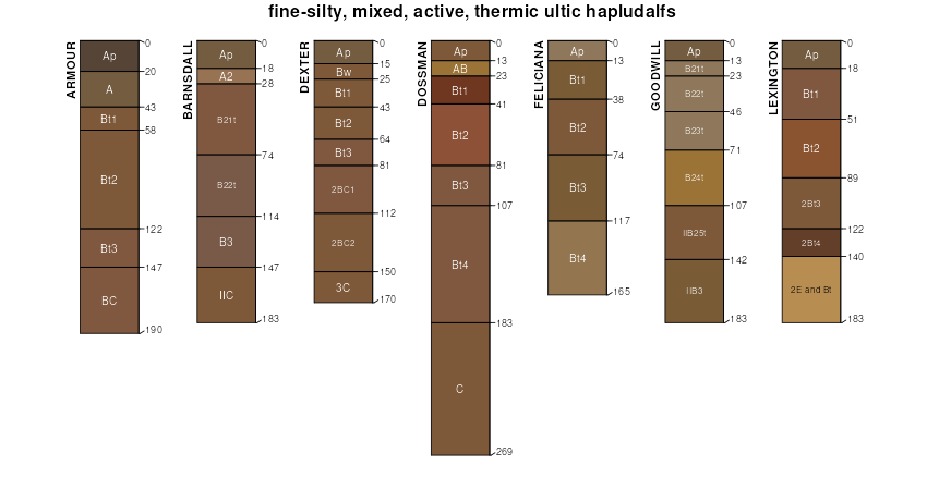
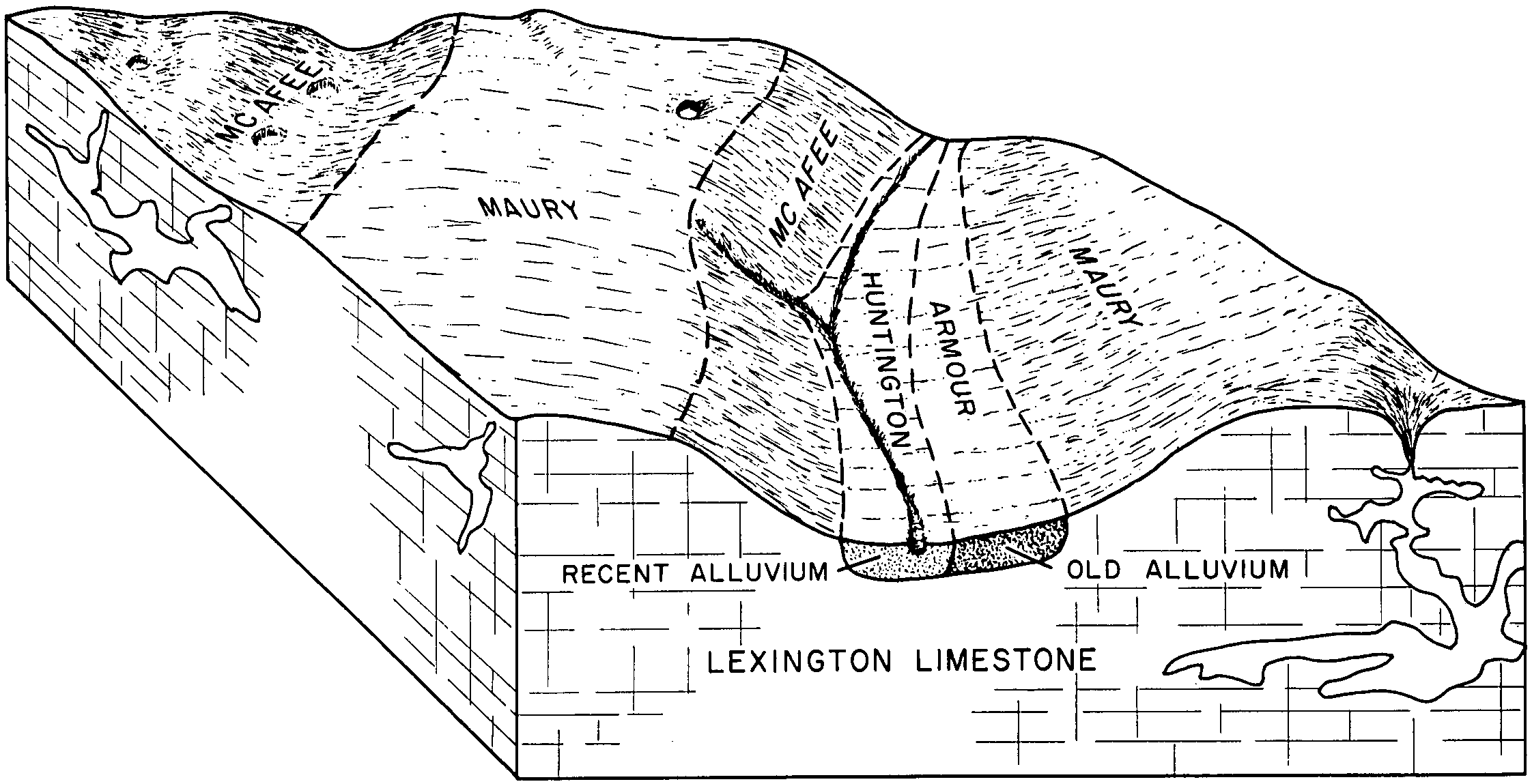
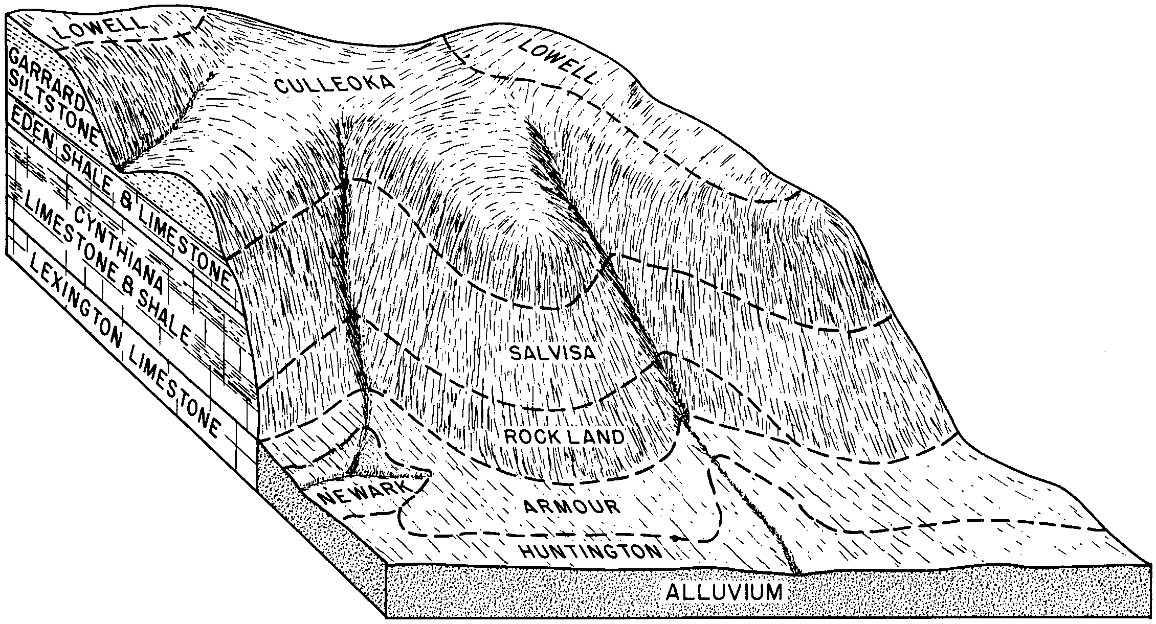
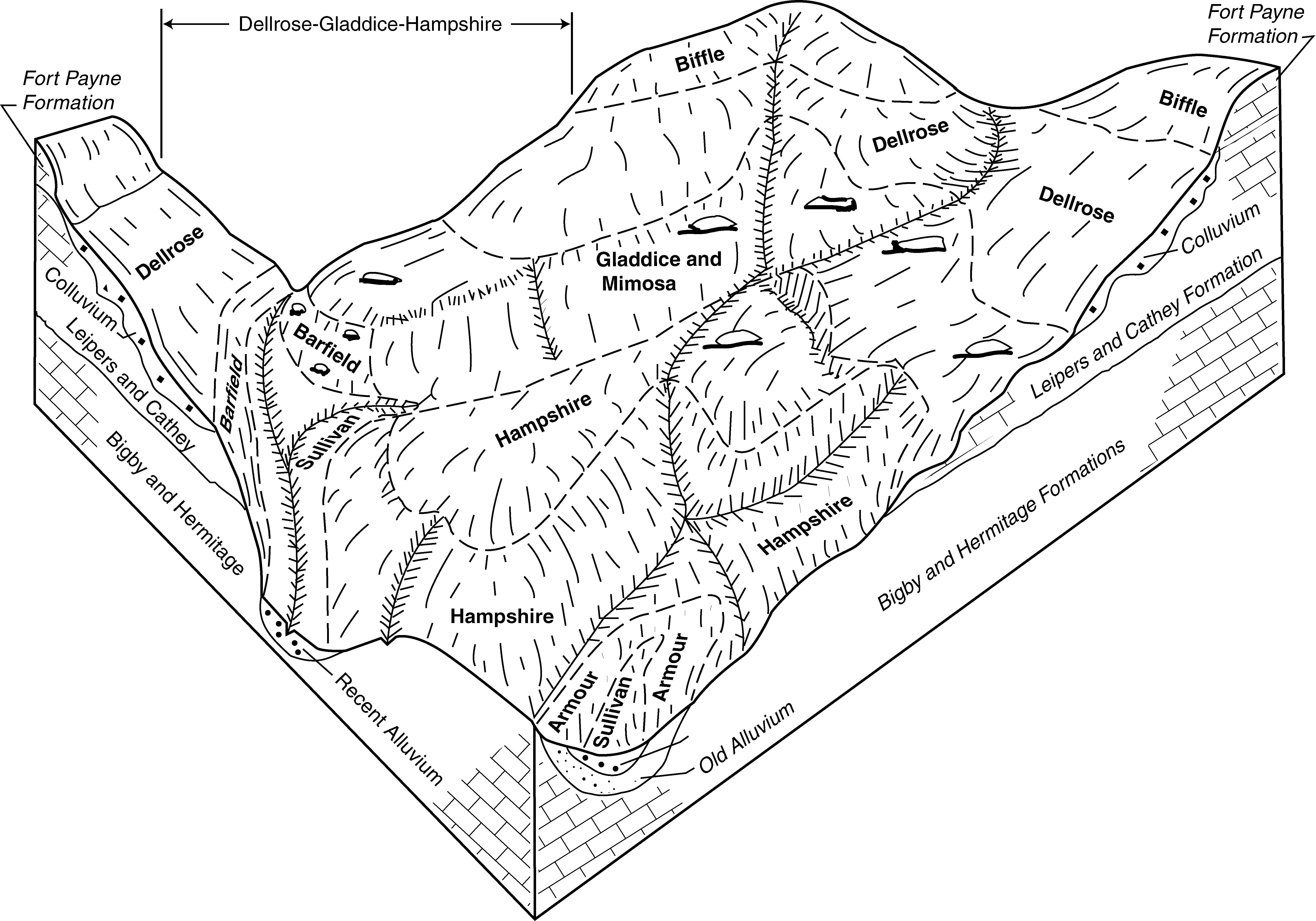
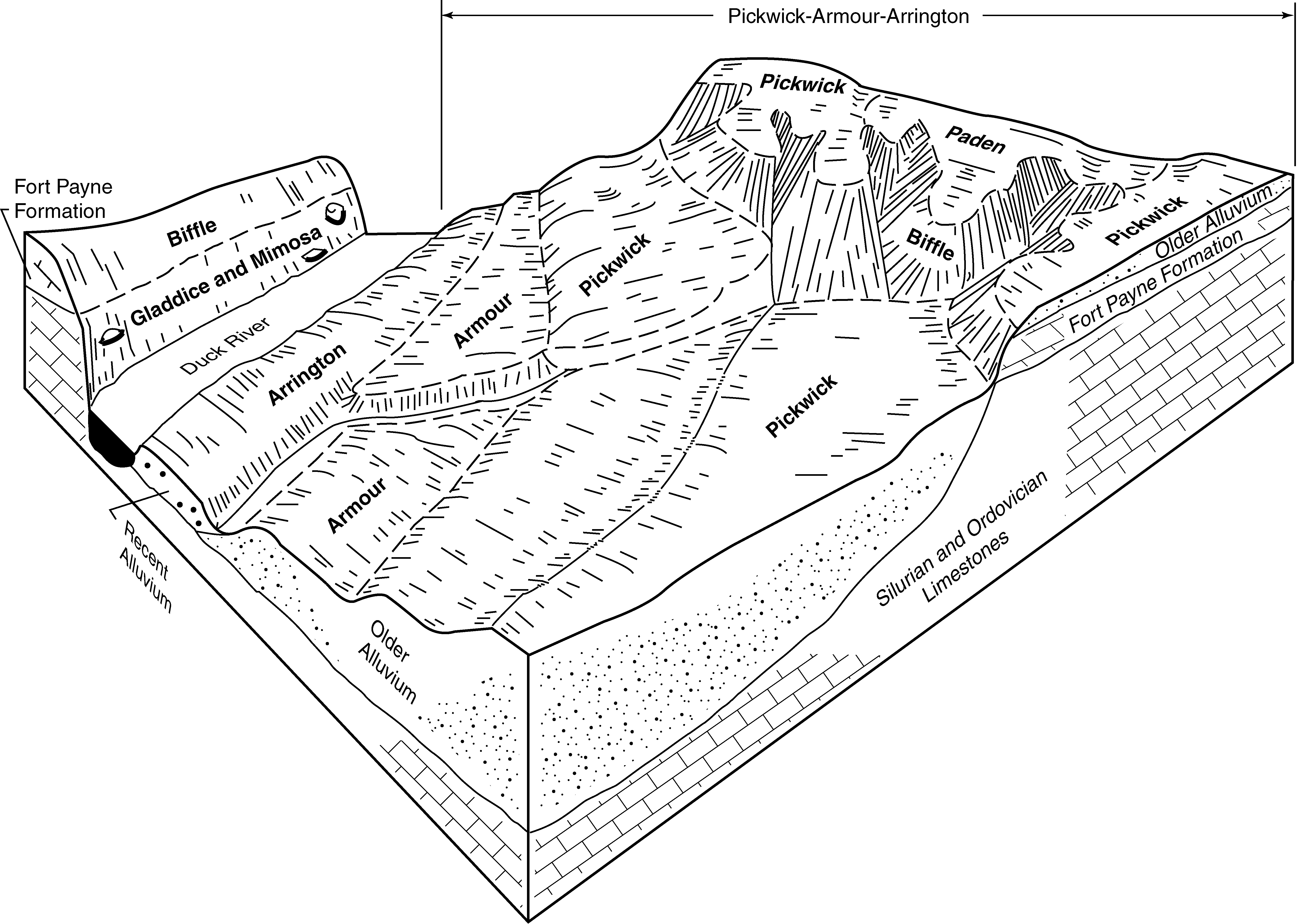
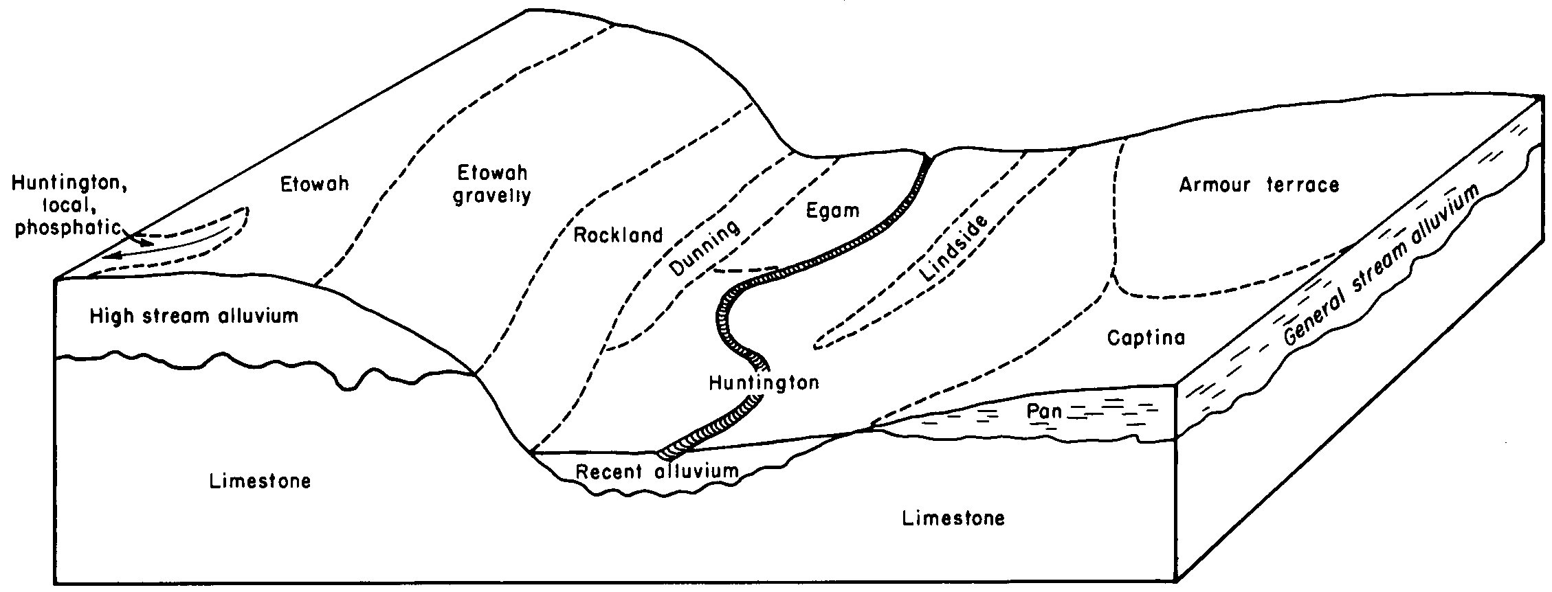
Official Series Description


Lab Data Summary

Aggregate lab data for the ARMOUR soil series. This aggregation is based on all pedons with a current taxon name of ARMOUR, and applied along 1-cm thick depth slices. Solid lines are the slice-wise median, bounded on either side by the interval defined by the slice-wise 5th and 95th percentiles. The median is the value that splits the data in half. Five percent of the data are less than the 5th percentile, and five percent of the data are greater than the 95th percentile. Values along the right hand side y-axis describe the proportion of pedon data that contribute to aggregate values at this depth. For example, a value of "90%" at 25cm means that 90% of the pedons correlated to ARMOUR were used in the calculation. Source: KSSL snapshot . Methods used to assemble the KSSL snapshot used by SoilWeb / SDE

Click the image to view it full size.

Pedons used in the lab summary:

MLRALab IDPedon IDTaxonnameCINSSL / NASIS ReportsLink To SoilWeb GMap
122S70AL-077-370AL077003-pgmArmour3Primary | Supplementary | Taxonomy | Pedon | Water Retention | Correlation | Andic Soil Properties34.8683395385742,-87.4186172485352
12340A49191954TN031006Armour3Primary | Supplementary | Taxonomy | Pedon | Water Retention | Correlation | Andic Soil Properties35.5780563,-86.1922226
12340A49201954TN031016Armour3Primary | Supplementary | Taxonomy | Pedon | Water Retention | Correlation | Andic Soil Properties35.5778809,-86.2383041
n/a40A49211955TN031029Armour4Primary | Supplementary | Taxonomy | Pedon | Water Retention | Correlation | Andic Soil Propertiesn/a
n/a40A49221955TN031030Armour4Primary | Supplementary | Taxonomy | Pedon | Water Retention | Correlation | Andic Soil Propertiesn/a
n/a40A43641960TN187021Armour6Primary | Supplementary | Taxonomy | Pedon | Water Retention | Correlation | Andic Soil Propertiesn/a
n/a40A43331960TN187023Armour6Primary | Supplementary | Taxonomy | Pedon | Water Retention | Correlation | Andic Soil Propertiesn/a

Water Balance

Monthly water balance estimated using a leaky-bucket style model for the ARMOUR soil series. Monthly precipitation (PPT) and potential evapotranspiration (PET) have been estimated from the 50th percentile of gridded values (PRISM 1981-2010) overlapping with the extent of SSURGO map units containing each series as a major component. Monthly PET values were estimated using the method of Thornthwaite (1948). These (and other) climatic parameters are calculated with each SSURGO refresh and provided by the fetchOSD function of the soilDB package. Representative water storage values (“AWC” in the figures) were derived from SSURGO by taking the 50th percentile of profile-total water storage (sum[awc_r * horizon thickness]) for each soil series. Note that this representation of “water storage” is based on the average ability of most plants to extract soil water between 15 bar (“permanent wilting point”) and 1/3 bar (“field capacity”) matric potential. Soil moisture state can be roughly interpreted as “dry” when storage is depleted, “moist” when storage is between 0mm and AWC, and “wet” when there is a surplus. Clearly there are a lot of assumptions baked into this kind of monthly water balance. This is still a work in progress.

Click the image to view it full size.


Click the image to view it full size.

Sibling Summary

Siblings are those soil series that occur together in map units, in this case with the ARMOUR series. Sketches are arranged according to their subgroup-level taxonomic structure. Source: SSURGO snapshot , parsed OSD records and snapshot of SC database .

Click the image to view it full size.

Select annual climate data summaries for the ARMOUR series and siblings. Series are sorted according to hierarchical clustering of median values. Source: SSURGO map unit geometry and 1981-2010, 800m PRISM data .

Click the image to view it full size.

Geomorphic description summaries for the ARMOUR series and siblings. Series are sorted according to hierarchical clustering of proportions and relative hydrologic position within an idealized landform (e.g. top to bottom). Most soil series (SSURGO components) are associated with a hillslope position and one or more landform-specific positions: hills, mountain slopes, terraces, and/or flats. Proportions can be interpreted as an aggregate representation of geomorphic membership. The values printed to the left (number of component records) and right (Shannon entropy) of stacked bars can be used to judge the reliability of trends. Small Shannon entropy values suggest relatively consistent geomorphic association, while larger values suggest lack thereof. Source: SSURGO component records .

Click the image to view it full size.

Click the image to view it full size.

There are insufficient data to create the 3D mountains figure.

Click the image to view it full size.

Click the image to view it full size.

Competing Series

Soil series competing with ARMOUR share the same family level classification in Soil Taxonomy. Source: parsed OSD records and snapshot of the SC database .

Click the image to view it full size.

Select annual climate data summaries for the ARMOUR series and competing. Series are sorted according to hierarchical clustering of median values. Source: SSURGO map unit geometry and 1981-2010, 800m PRISM data .

Click the image to view it full size.

Geomorphic description summaries for the ARMOUR series and competing. Series are sorted according to hierarchical clustering of proportions and relative hydrologic position within an idealized landform (e.g. top to bottom). Proportions can be interpreted as an aggregate representation of geomorphic membership. Most soil series (SSURGO components) are associated with a hillslope position and one or more landform-specific positions: hills, mountain slopes, terraces, and/or flats. The values printed to the left (number of component records) and right (Shannon entropy) of stacked bars can be used to judge the reliability of trends. Shannon entropy values close to 0 represent soil series with relatively consistent geomorphic association, while values close to 1 suggest lack thereof. Source: SSURGO component records .

Click the image to view it full size.

Click the image to view it full size.

There are insufficient data to create the 3D mountains figure.

Click the image to view it full size.

There are insufficient data to create the 3D flats position figure.

Soil series sharing subgroup-level classification with ARMOUR, arranged according to family differentiae. Hovering over a series name will print full classification and a small sketch from the OSD. Source: snapshot of SC database .

Block Diagrams

Click a link below to display the diagram. Note that these diagrams may be from multiple survey areas.

  1. KY-2012-01-27-66 | Fayette County - February 1968

    Relationship of soils to topography and underlying material in association 1. Unshaded areas represent caverns or sinkholes in the limestone bedrock (Soil Survey of Fayette County, Kentucky; February 1968).

  2. KY-2012-01-27-70 | Fayette County - February 1968

    Relationship of soils to topography and underlying material in association 5 (Soil Survey of Fayette County, Kentucky; February 1968).

  3. TN-2010-11-02-04 | Clay County - 2004

    The relatiohship between soils and landscape in the Armour-Holston-Lindside general soil map unit (Soil Survey of Clay County, Tennessee; 2004)

  4. TN-2010-11-02-11 | Hickman County - 2008

    Typical pattern of soils and parent material in the Dellrose-Gladdice-Hamsphire general soil map unit (Soil Survey of Hickman County, Tennessee; 2008).

  5. TN-2010-11-02-12 | Hickman County - 2008

    Typical pattern of soils and parent material in the Pickwick-Armour-Arrington general soil map unit (Soil Survey of Hickman County, Tennessee; 2008).

  6. TN-2010-11-02-31 | Perry County - 2006

    Relationship of soils, parent material, and topography in the Paden-Ellisville-Woodmont general soil map unit (Soil Survey of Perry County, Tennessee; 2006).

  7. TN-2012-03-16-03 | Cheatham County - 2002

    Relationship of soils to topography and the underlying material in the Byler-Nolin-Armour-Arrington general soil map unit. The Hawthorne and Suphura soils are adjacen to the map unit (Soil Survey of Cheatham County, TN; 2002).

  8. TN-2012-03-16-06 | Dickson County - 2002

    The relationship of soils, landscape, and parent material in the Saffell-Lax and the Armour-Humphreys-Sullivan general soil map units (Soil Survey of Dickson County, TN; 2002).

  9. TN-2012-03-19-19 | Maury County - October 1959

    Sketch showing relative positions of soils in the Dellrose-Frankstown-Mimosa (cherty) assciation (Soil Survey of Maury County, TN; 1959).

  10. TN-2012-03-19-20 | Maury County - October 1959

    Sketch showing relative positions of soils in the Braxton-Maury-Armour assciation (Soil Survey of Maury County, TN; 1959).

  11. TN-2012-03-19-23 | Maury County - October 1959

    Sketch showing relative positions of soils in the Etowah-Huntington (local allvuium phosphatic phase)-Emory and Huntington-Lindside-Armour (terrace phases)-Egam assciations (Soil Survey of Maury County, TN; 1959).

  12. TN-2012-03-19-29 | Trousdale County - 2001

    Typical pattern of soils and underlying material in the Harpeth-Arrington general soil map unit (Soil Survey of Trousdale County, TN; 2001).

  13. TN-2012-03-19-39 | Williamson County - August 1964

    Major and minor soils and underlying parent materials in the Sulphura-Dellrose-Bodine association (Soil Survey of Williamson County, TN; 1964).

  14. TN-2012-03-19-40 | Williamson County - August 1964

    Major and minor soils and underlying parent materials in the Stiversville-Culleoka-Inman association (Soil Survey of Williamson County, TN; 1964).

Map Units

Map units containing ARMOUR as a major component. Limited to 250 records.

Map Unit Name Symbol Map Unit Area (ac) Map Unit Key National Map Unit Symbol Soil Survey Area Publication Date Map Scale
Armour silt loamAr1274523034kk82al07719731:20000
Armour silt loam, 6 to 12 percent slopesArC38922323472dxy6ky61019681:12000
Armour silt loam, 2 to 6 percent slopesArB31522323382dxxxky61019681:12000
Armour silt loam, 0 to 3 percent slopes, rarely floodedArA58625453222qsb5tn00520111:12000
Armour silt loam, 2 to 5 percent slopes, erodedArB228825453232qsb6tn00520111:12000
Armour silt loam, 5 to 12 percent slopes, erodedArC21025453242qsb7tn00520111:12000
Armour silt loam, 2 to 5 percent slopesArB6465244022td31tn01519991:24000
Armour silt loam, 0 to 2 percent slopesArA2315244012td2ztn01519991:24000
Armour silt loam, 5 to 12 percent slopesAmC213335270022td32tn02119911:24000
Armour silt loam, 2 to 5 percent slopesAmB28675270012td31tn02119911:24000
Armour silt loam, 0 to 2 percent slopesAmA2575270002td2ztn02119911:24000
Armour silt loam, 5 to 12 percent slopesAmC29675310292td32tn02720021:24000
Armour silt loam, 2 to 5 percent slopesAmB6426368002td31tn02720021:24000
Armour silt loam, 2 to 5 percent slopesAa7255248552td31tn03119561:20000
Armour silt loam, 5 to 12 percent slopesAb2765248562td32tn03119561:20000
Armour silt loam, 2 to 5 percent slopesAmB87195233992td31tn03719771:15840
Armour silt loam, 5 to 12 percent slopesAmC20965234002td32tn03719771:15840
Armour silt loam, 5 to 15 percent slopes, severely erodedAmC31543523401kkmxtn03719771:15840
Armour silt loam, 2 to 5 percent slopesArB17505270402td31tn04119681:15840
Armour silt loam, 5 to 12 percent slopesArC15265270412td32tn04119681:15840
Armour silt loam, 2 to 5 percent slopes, gravelly substratumArB6000527099kph6tn04319931:24000
Armour silt loam, 5 to 12 percent slopesArC49615271002td32tn04319931:24000
Armour silt loam, 0 to 2 percent slopes, gravelly substratum, occasionally floodedArA3850527098kph5tn04319931:24000
Armour silt loam, 2 to 5 percent slopesArB118615272732td31tn05519651:15840
Armour silt loam, 5 to 12 percent slopesArC241035272742td32tn05519651:15840
Armour silt loam, 0 to 2 percent slopesArA22135272722td2ztn05519651:15840
Armour silt loam, 5 to 12 percent slopes, erodedArC21325452362qs79tn07920121:12000
Armour silt loam, 2 to 5 percent slopesAmB30265274482td31tn08119971:24000
Armour silt loam, 5 to 12 percent slopesAmC19125274492td32tn08119971:24000
Armour silty clay loam, 5 to 12 percent slopes, severely erodedAmC35685274502v58rtn08119971:24000
Armour silt loam, 2 to 5 percent slopesAmB12435301712td31tn08719991:24000
Armour silt loam, 5 to 12 percent slopesAmC26245301722td32tn08719991:24000
Armour silt loam, 12 to 20 percent slopesAmD21275301732td30tn08719991:24000
Armour silt loam, 5 to 12 percent slopesAmC2545308372td32tn10119991:24000
Armour silt loam, 2 to 5 percent slopesAmB205308312td31tn10119991:24000
Armour silt loam, 2 to 5 percent slopesAmB115495258152td31tn10319991:24000
Armour silt loam, 2 to 5 percent slopesAmB18195276892td31tn11119921:24000
Armour silt loam, 5 to 12 percent slopesAmC27145276902td32tn11119921:24000
Armour silt loam, 2 to 5 percent slopesAmB80365240522td31tn11719991:24000
Armour silt loam, 5 to 12 percent slopesAmC217395240532td32tn11719991:24000
Armour silt loam, eroded gently sloping phaseAe13658527728kq4htn11919551:20000
Armour silt loam, 5 to 12 percent slopesAg57975277302td32tn11919551:20000
Armour silt loam, eroded gently sloping terrace phaseAf4636527729kq4jtn11919551:20000
Armour silty clay loam, 5 to 12 percent slopes, severely erodedAh13935277312v58rtn11919551:20000
Armour silt loam, 2 to 5 percent slopesAmB8266257262td31tn12720021:24000
Armour silt loam, 0 to 2 percent slopesArA12575605982td2ztn13520001:24000
Armour silt loam, 2 to 5 percent slopesAmB2865605972td31tn13520001:24000
Armour silt loam, 0 to 2 percent slopes, occasionally floodedAmA47560596ltbrtn13520001:24000
Armour silt loam, 2 to 5 percent slopesAmB25475281962td31tn14919741:15840
Armour silt loam, 0 to 2 percent slopesAmA8155281952td2ztn14919741:15840
Armour silt loam, 5 to 12 percent slopesAmC5295281972td32tn14919741:15840
Armour silt loam, 5 to 12 percent slopesAmC263275298032td32tn15919921:24000
Armour silt loam, 2 to 5 percent slopesAmB251585298022td31tn15919921:24000
Armour silt loam, 12 to 20 percent slopesAmD211135298042td30tn15919921:24000
Armour silt loam, 5 to 12 percent slopesPh92623969542td32tn16119531:20000
Armour silt loam, 2 to 5 percent slopesEf41323969052td31tn16119531:20000
Armour silt loam, 12 to 20 percent slopesPg26223969532td30tn16119531:20000
Armour silt loam, 2 to 5 percent slopes, erodedPk8323969552lg74tn16119531:20000
Armour silt loam, 2 to 5 percent slopesAmB18895283422td31tn16519931:20000
Armour silt loam, 2 to 5 percent slopesAmB18065300052td31tn16919931:24000
Armour silt loam, 0 to 2 percent slopes, occasionally floodedAmA2891327990c09btn18119961:24000
Armour silt loam, gravelly substratum, 2 to 5 percent slopesAmB2213327991c09ctn18119961:24000
Armour silt loam, 2 to 5 percent slopes, erodedArB29850523456kkpptn18719611:15840
Armour silt loam, 2 to 5 percent slopesArB72105234552td31tn18719611:15840
Armour silt loam, 5 to 12 percent slopes, erodedArC25410523458kkprtn18719611:15840
Armour silt loam, 0 to 2 percent slopesArA23525234542td2ztn18719611:15840
Armour silty clay loam, 5 to 12 percent slopes, severely erodedAtC35715234592v58rtn18719611:15840
Armour silt loam, 5 to 12 percent slopesArC4655234572td32tn18719611:15840
Humphreys silt loam, 2 to 5 percent slopesHrB436523531kks3tn18719611:15840
Armour silt loam, 2 to 5 percent slopesArB40645284402td31tn18919881:20000
Armour silt loam, 5 to 12 percent slopesArC231525284412td32tn18919881:20000
Armour silt loam, 12 to 20 percent slopesArD25565284422td30tn18919881:20000
Armour silt loam, 5 to 12 percent slopesArC258024273912td32tn61019601:15840
Armour silt loam, 2 to 5 percent slopesArB22024273902td31tn61019601:15840
Armour silt loam, 12 to 20 percent slopesArD218724273922td30tn61019601:15840

Map of Series Extent

Approximate geographic distribution of the ARMOUR soil series. To learn more about how this distribution was mapped, or to compare this soil series extent to others, use the Series Extent Explorer (SEE) application. Source: generalization of SSURGO geometry .