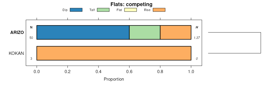
| Arizo gravelly sandy loam, 1 to 5 percent slopes, nonflooded | 4 | 18815 | 52347 | 1rgm | az623 | 1994 | 1:24000 |
Arizo very gravelly sandy loam, 1 to 5 percent slopes, flooded | 5 | 9982 | 52360 | 1rh1 | az623 | 1994 | 1:24000 |
Arizo-Franconia-Riverwash complex, dry, 1 to 3 percent slopes | 10 | 18670 | 1507873 | 1mm22 | az627 | 2005 | 1:24000 |
Arizo-Franconia-Riverwash complex, 1 to 3 percent slopes | 9 | 10212 | 1507872 | 1mm21 | az627 | 2005 | 1:24000 |
Ireteba family-Arizo complex, 1 to 3 percent slopes | 65 | 4331 | 1507928 | 1mm3v | az627 | 2005 | 1:24000 |
Cowan and Arizo soils | Cr | 899 | 802858 | vyfn | az643 | 1967 | 1:31680 |
Anthony-Arizo complex | 6 | 5670 | 53104 | 1s81 | az645 | 1982 | 1:24000 |
Arizo cobbly sandy loam | 8 | 4830 | 53136 | 1s92 | az645 | 1982 | 1:24000 |
Anthony-Arizo complex, low precipitation | 7 | 2980 | 53123 | 1s8n | az645 | 1982 | 1:24000 |
Arizo gravelly sandy loam, 2 to 5 percent slopes | AvB | 3910 | 53593 | 1srt | az662 | 1966 | 1:20000 |
Arizo gravelly loam, 0 to 2 percent slopes | AzA | 1120 | 53595 | 1srw | az662 | 1966 | 1:20000 |
Arizo gravelly sandy loam, 0 to 2 percent slopes | AvA | 1070 | 53592 | 1srs | az662 | 1966 | 1:20000 |
Arizo loam, 0 to 2 percent slopes | AwA | 550 | 53594 | 1srv | az662 | 1966 | 1:20000 |
Arizo sandy loam, 0 to 2 percent slopes | AuA | 480 | 53591 | 1srr | az662 | 1966 | 1:20000 |
Arizo soils | 2 | 5806 | 53660 | 1stz | az664 | 1975 | 1:24000 |
Arizo gravelly sandy loam | Az | 1013 | 54345 | 1tk2 | az668 | 1968 | 1:20000 |
Arizo-Riverwash complex, 0 to 3 percent slopes | 5 | 33156 | 53844 | 1t0x | az669 | 1993 | 1:24000 |
Arizo family-Riverwash complex, 0 to 3 percent slopes | 3 | 1706 | 55027 | 1v82 | az671 | 2000 | 1:24000 |
Arizo-Franconia-Riverwash complex, 1 to 3 percent slopes | 6 | 26681 | 798389 | vssh | az697 | 2005 | 1:24000 |
Arizo-Detrital-Nickel complex, 2 to 6 percent slopes | 5 | 21124 | 798356 | vsrf | az697 | 2005 | 1:24000 |
Arizo-Riverwash complex, dry, 0 to 1 percent slopes | 9 | 12824 | 798397 | vssr | az697 | 2005 | 1:24000 |
Arizo-Riverwash complex, 1 to 4 percent slopes | 8 | 5251 | 798355 | vsrd | az697 | 2005 | 1:24000 |
Arizo-Riverwash complex, 0 to 1 percent slopes | 7 | 4831 | 798394 | vssn | az697 | 2005 | 1:24000 |
Arizo-Riverwash complex, moist, 1 to 3 percent slopes | 10 | 4387 | 798375 | vss1 | az697 | 2005 | 1:24000 |
Ireteba family-Arizo complex, 1 to 3 percent slopes | 69 | 17 | 1147387 | 17hyh | az697 | 2005 | 1:24000 |
Arizo-Riverwash complex, 1 to 3 percent slopes | 3 | 5230 | 54478 | 1tpc | az699 | 1993 | 1:24000 |
Arizo-Lostman complex, 1 to 5 percent slopes | 2 | 1300 | 54533 | 1tr4 | az699 | 1993 | 1:24000 |
Meadview-Arizo complex, 1 to 5 percent slopes | 79 | 4543 | 615968 | nnyy | az701 | 2001 | 1:24000 |
Arizo very gravelly sandy loam, 1 to 5 percent slopes | 7 | 1332 | 615798 | nnsg | az701 | 2001 | 1:24000 |
Arizo-Riverwash complex, 0 to 3 percent slopes | 4 | 10522 | 54610 | 1ttm | az703 | 1993 | 1:24000 |
Arizo gravelly loamy sand, 2 to 9 percent slopes | 104 | 19779 | 463808 | hkmk | ca670 | 1977 | 1:24000 |
CAJON-ARIZO COMPLEX, 2 TO 15 PERCENT SLOPES* | 118 | 66000 | 463937 | hkrq | ca671 | 1978 | 1:24000 |
ARIZO GRAVELLY LOAMY SAND, 2 TO 9 PERCENT SLOPES | 100 | 9500 | 463919 | hkr4 | ca671 | 1978 | 1:24000 |
Arizo gravelly loamy sand, 0 to 5 percent slopes | AsB | 14025 | 457802 | hcct | ca675 | 1968 | 1:24000 |
Arizo loamy fine sand, 0 to 2 percent slopes | AtA | 4450 | 457803 | hccv | ca675 | 1968 | 1:24000 |
Arizo-Granitepass-Bikelake complex, 2 to 8 percent slopes | 224 | 28772 | 466632 | hnkn | ca697 | 2000 | 1:24000 |
Arizo very gravelly sandy loam, 2 to 4 percent slopes | 225 | 13992 | 466633 | hnkp | ca697 | 2000 | 1:24000 |
Nellake-Arizo association, 4 to 15 percent slopes | 415 | 13256 | 466609 | hnjx | ca697 | 2000 | 1:24000 |
Arizo-Twobitter association, 2 to 8 percent slopes | 222 | 12127 | 466631 | hnkm | ca697 | 2000 | 1:24000 |
Twobitter-Arizo association, 2 to 8 percent slopes | 360 | 11413 | 466660 | hnlk | ca697 | 2000 | 1:24000 |
Cavespring-Arizo-Cavespring very cobbly complex, 2 to 15 percent slopes | 211 | 10582 | 466627 | hnkh | ca697 | 2000 | 1:24000 |
Arizo-Cajon complex, 2 to 8 percent slopes | 232 | 9454 | 466598 | hnjk | ca697 | 2000 | 1:24000 |
Garlock-Ambrosia-Arizo complex, 2 to 8 percent slopes | 220 | 7752 | 466596 | hnjh | ca697 | 2000 | 1:24000 |
Werewolf-Arizo association, 2 to 8 percent slopes | 450 | 5495 | 466678 | hnm4 | ca697 | 2000 | 1:24000 |
Arizo complex, 2 to 8 percent slopes | 221 | 5460 | 466597 | hnjj | ca697 | 2000 | 1:24000 |
Arizo very gravelly sandy loam, 0 to 2 percent slopes | 580 | 4813 | 466729 | hnns | ca697 | 2000 | 1:24000 |
Luckyfuse-Arizo association, 2 to 4 percent slopes | 481 | 3395 | 466728 | hnnr | ca697 | 2000 | 1:24000 |
Arizo-Luckyfuse-Fortirwin association, 2 to 8 percent slopes | 227 | 2626 | 466693 | hnmm | ca697 | 2000 | 1:24000 |
Crosgrain-Cronese-Arizo association, 2 to 8 percent slopes | 112 | 2508 | 466685 | hnmc | ca697 | 2000 | 1:24000 |
Fortirwin-Goldivide-Arizo association, 2 to 8 percent slopes | 320 | 2116 | 466652 | hnl9 | ca697 | 2000 | 1:24000 |
Arizo extremely gravelly sandy loam, 4 to 8 percent slopes, extremely stony | 226 | 2044 | 466634 | hnkq | ca697 | 2000 | 1:24000 |
Arizo-Gravesumit-Daisy-Hypoint complex, 2 to 8 percent slopes | 3518 | 9631 | 1403491 | 1j3fx | ca698 | 2022 | 1:24000 |
Arizo-Hypoint, saline association, 2 to 8 percent slopes | 3512 | 5225 | 1403460 | 1j3dx | ca698 | 2022 | 1:24000 |
Arizo sand, 2 to 4 percent slopes | 3515 | 5053 | 1403463 | 1j3f0 | ca698 | 2022 | 1:24000 |
Daisy-Arizo association, 0 to 4 percent slopes | 4401 | 2849 | 1403478 | 1j3fh | ca698 | 2022 | 1:24000 |
Arizo association, flooded, 2 to 4 percent slopes | 3516 | 1603 | 1403464 | 1j3f1 | ca698 | 2022 | 1:24000 |
Arizo association, 0 to 4 percent slopes | 4402 | 1572 | 1403479 | 1j3fj | ca698 | 2022 | 1:24000 |
Arizo-Burntshack association, 2 to 8 percent slopes | 3519 | 1416 | 1403510 | 1j3gj | ca698 | 2022 | 1:24000 |
Oldwoman-Calcio-Arizo complex, 2 to 8 percent slopes | 4100 | 1295 | 1403498 | 1j3g4 | ca698 | 2022 | 1:24000 |
Arizo extremely gravelly loamy sand, 2 to 8 percent slopes | 3511 | 1063 | 1403459 | 1j3dw | ca698 | 2022 | 1:24000 |
Arizo-Crosgrain-Twobitter association, 2 to 15 percent slopes | 3513 | 931 | 1403461 | 1j3dy | ca698 | 2022 | 1:24000 |
Arizo association, 2 to 4 percent slopes | 3517 | 694 | 1403465 | 1j3f2 | ca698 | 2022 | 1:24000 |
Arizo extremely gravelly loamy sand, dry, 2 to 8 percent slopes | 3510 | 675 | 1403458 | 1j3dv | ca698 | 2022 | 1:24000 |
Arizo saline, 0 to 2 percent slopes | 4720 | 251 | 1403484 | 1j3fp | ca698 | 2022 | 1:24000 |
Gravesumit-Arizo-Owlshead association, 2 to 30 percent slopes | 4062 | 234 | 1403514 | 1j3gn | ca698 | 2022 | 1:24000 |
Arizo-Hypoint association, 2 to 8 percent slopes | 3514 | 134 | 1403462 | 1j3dz | ca698 | 2022 | 1:24000 |
Arizo extremely gravelly loamy sand, dry, 2 to 8 percent slopes | 274 | 19740 | 3229652 | hnqy | ca699 | | 1:24000 |
Arizo, dry-Twobitter association, 2 to 8 percent slopes | 276 | 17803 | 3229628 | hnq5 | ca699 | | 1:24000 |
Arizo sand, 2 to 4 percent slopes | 279 | 14623 | 3229653 | hnqz | ca699 | | 1:24000 |
Arizo extremely gravelly loamy sand, 2 to 8 percent slopes | 270 | 13639 | 3229649 | hnqv | ca699 | | 1:24000 |
Arizo-Hypoint-Olympus complex, 2 to 8 percent slopes | 297 | 12099 | 3229696 | hnsc | ca699 | | 1:24000 |
Arizo-Hypoint association, 2 to 8 percent slopes | 295 | 11321 | 3229687 | hns2 | ca699 | | 1:24000 |
Cajon-Arizo-Bluepoint complex, 2 to 8 percent slopes | 105 | 7013 | 3229589 | hnnx | ca699 | | 1:24000 |
Arizo-Twobitter association, 2 to 4 percent slopes | 293 | 5690 | 3229675 | hnrp | ca699 | | 1:24000 |
Arizo association, 2 to 4 percent slopes | 292 | 5455 | 3229655 | hnr1 | ca699 | | 1:24000 |
Haleburu-Arizo association, 2 to 15 percent slopes | 401 | 4402 | 3229612 | hnpn | ca699 | | 1:24000 |
Twobitter-Cajon-Arizo complex, 2 to 8 percent slopes | 261 | 3655 | 3229674 | hnrn | ca699 | | 1:24000 |
Arizo extremely gravelly loam, 8 to 15 percent slopes | 278 | 3477 | 3229650 | hnqw | ca699 | | 1:24000 |
Arizo-Hypoint, saline association, 2 to 8 percent slopes | 296 | 2707 | 3229688 | hns3 | ca699 | | 1:24000 |
Arizo-Tonopah association, 2 to 8 percent slopes | 290 | 2196 | 3229654 | hnr0 | ca699 | | 1:24000 |
Arizo association, 0 to 4 percent slopes, frequently flooded | 272 | 669 | 3229627 | hnq4 | ca699 | | 1:24000 |
Arizo complex, 2 to 4 percent slopes, frequently flooded | 298 | 635 | 3229699 | hnsg | ca699 | | 1:24000 |
Arizo complex, 2 to 4 percent slopes | 294 | 527 | 3229676 | hnrq | ca699 | | 1:24000 |
Arizo gravelly loamy sand, 5 to 9 percent slopes | 115bo | 265 | 2229104 | 2dtkl | ca732 | 1998 | 1:24000 |
Arizo-Yellowrock complex, 5 to 9 percent slopes | 118bo | 27 | 2229105 | 2dtkm | ca732 | 1998 | 1:24000 |
Arizo-Yellowrock complex, 5 to 9 percent slopes | 118bo | 620 | 2230047 | 2dvk0 | ca740 | 1996 | 1:24000 |
Arizo gravelly loamy sand, 5 to 9 percent slopes | 115bo | 344 | 2230045 | 2dvjy | ca740 | 1996 | 1:24000 |
Arizo-Yellowrock complex, 9 to 15 percent slopes | 119bo | 110 | 2230048 | 2dvk1 | ca740 | 1996 | 1:24000 |
Arizo gravelly loamy sand, 9 to 15 percent slopes | 116bo | 33 | 2230046 | 2dvjz | ca740 | 1996 | 1:24000 |
Arizo-Yellowrock complex, 5 to 9 percent slopes | 118bo | 120 | 2390645 | 2l7nl | ca763 | 1984 | 1:24000 |
Cajon-Hypoint-Arizo association, 1 to 4 percent slopes | 3526 | 4208 | 2505202 | 2pz59 | ca794 | 2012 | 1:24000 |
Yuccabutte-Arizo association, 2 to 15 percent slopes | 4271 | 3330 | 2508181 | 2pz5l | ca794 | 2012 | 1:24000 |
Arizo complex, 2 to 8 percent slopes | 4403 | 821 | 2517398 | 2qb0v | ca794 | 2012 | 1:24000 |
Arizo-Orwash complex, 2 to 8 percent slopes | 429 | 83753 | 3381268 | 2zrjb | ca795 | 2023 | 1:24000 |
Ambrosia-Arizo-Vontrigger complex, 2 to 5 percent slopes | 702 | 47339 | 2915431 | 2w47q | ca795 | 2023 | 1:24000 |
Cajon-Arizo-Filaree complex, 4 to 8 percent slopes | 382 | 16282 | 2967031 | 2ww2r | ca795 | 2023 | 1:24000 |
Yuccabutte-Arizo association, 2 to 15 percent slopes | 4271 | 11771 | 3394075 | 2pz5l | ca795 | 2023 | 1:24000 |
Arizo loamy sand, 2 to 8 percent slopes | 3520 | 4461 | 3394072 | 20g83 | ca795 | 2023 | 1:24000 |
Peskah-Arizo association | 4180 | 4398 | 3394083 | 20g89 | ca795 | 2023 | 1:24000 |
Arizo-Riverwash association | 454 | 3269 | 3394066 | hqxd | ca795 | 2023 | 1:24000 |
Arizo-Yellowrock complex, 5 to 9 percent slopes | 118 | 3221 | 488011 | jct9 | ca802 | 1996 | 1:24000 |
Arizo gravelly loamy sand, 5 to 9 percent slopes | 115 | 1173 | 488008 | jct6 | ca802 | 1996 | 1:24000 |
Arizo gravelly loamy sand, 9 to 15 percent slopes | 116 | 1142 | 488009 | jct7 | ca802 | 1996 | 1:24000 |
Arizo-Yellowrock complex, 9 to 15 percent slopes | 119 | 684 | 488012 | jctb | ca802 | 1996 | 1:24000 |
Arizo-Yellowrock complex, 2 to 5 percent slopes | 117 | 673 | 488010 | jct8 | ca802 | 1996 | 1:24000 |
Arizo loamy sand, 2 to 8 percent slopes | 3520 | 32206 | 1860747 | 20g83 | ca805 | 2012 | 1:24000 |
Tonopah-Arizo association, 2 to 8 percent slopes | 3640 | 7115 | 1860748 | 20g84 | ca805 | 2012 | 1:24000 |
Peskah-Arizo association | 4180 | 4793 | 1860753 | 20g89 | ca805 | 2012 | 1:24000 |
Yuccabutte-Arizo association, 2 to 15 percent slopes | 4271 | 230 | 3394076 | 2pz5l | ca805 | 2012 | 1:24000 |
Arizo-Riverwash association | 454 | 135 | 3394067 | hqxd | ca805 | 2012 | 1:24000 |
Glendale-Arizo complex | GD | 10622 | 57013 | 1xb4 | nm023 | 1967 | 1:31680 |
Arizo gravelly sandy loam | Ar | 335 | 56992 | 1x9g | nm023 | 1967 | 1:31680 |
Arizo and Vinton soils | AV | 10094 | 56006 | 1w8n | nm029 | 1967 | 1:24000 |
Tome-Arizo complex | TN | 7176 | 55832 | 1w31 | nm612 | 1970 | 1:24000 |
Arizo and Canutio soils, gently sloping | 13 | 13762 | 56488 | 1ws6 | nm660 | 1981 | 1:48000 |
Arizo-Riverwash complex, 1 to 3 percent slopes | 12 | 733 | 56487 | 1ws5 | nm660 | 1981 | 1:48000 |
Mimbres-Arizo-Riverwash association, 0 to 5 percent slopes | 35 | 14287 | 59303 | 1zq0 | nm662 | 1979 | 1:48000 |
Arizo-Riverwash complex, 0 to 5 percent slopes | 621 | 43281 | 57151 | 1xgl | nm664 | 1984 | 1:24000 |
Arizo very stony loamy sand, 1 to 3 percent slopes | 118 | 1128 | 57080 | 2sps7 | nm664 | 1984 | 1:24000 |
Canutio and Arizo gravelly sandy loams MLRA 42 | Cb | 5766 | 634560 | 2spsh | nm690 | | 1:24000 |
Riverwash-Arizo complex | RF | 3100 | 634585 | p9bh | nm690 | | 1:24000 |
Bitter Spring-Arizo association, moderately sloping | BTC | 34124 | 469350 | hrdb | nv608 | 1967 | 1:24000 |
Arizo gravelly fine sand, 2 to 4 percent slopes | AVB | 5443 | 469345 | hrd5 | nv608 | 1967 | 1:24000 |
Arizo very gravelly loamy sand, 2 to 8 percent slopes | AXC | 2554 | 469346 | hrd6 | nv608 | 1967 | 1:24000 |
Arizo fine sand, 0 to 2 percent slopes | ATA | 647 | 469344 | hrd4 | nv608 | 1967 | 1:24000 |
Tonopah-Arizo association | TGC | 514 | 1712449 | 1vgy9 | nv608 | 1967 | 1:24000 |
Weiser-Arizo association | WFC | 184 | 1712441 | 1vgy1 | nv608 | 1967 | 1:24000 |
Alko-Arizo association | AA | 22125 | 653876 | pyds | nv611 | 1967 | 1:24000 |
Cave-Arizo association | CA | 2328 | 653879 | pydw | nv611 | 1967 | 1:24000 |
Arizo stony loamy sand, 0 to 12 percent slopes | CbC | 1150 | 491504 | jhfz | nv611 | 1967 | 1:24000 |
Arizo-Bluepoint association | AB | 1057 | 653877 | pydt | nv611 | 1967 | 1:24000 |
Arizo gravelly sand, 0 to 12 percent slopes | CaC | 961 | 491503 | jhfy | nv611 | 1967 | 1:24000 |
Longjim-Arizo association | LA | 762 | 653886 | pyf3 | nv611 | 1967 | 1:24000 |
Irongold-Arizo association | 1401 | 59555 | 478086 | j1h4 | nv754 | 1992 | 1:24000 |
Alko-Arizo association | 1170 | 26431 | 478046 | j1fv | nv754 | 1992 | 1:24000 |
Longjim-Arizo association | 1980 | 22698 | 478175 | j1l0 | nv754 | 1992 | 1:24000 |
Mormount-Arizo association | 1300 | 13789 | 478067 | j1gj | nv754 | 1992 | 1:24000 |
Wechech-Bard-Arizo association | 1017 | 12811 | 478012 | j1dr | nv754 | 1992 | 1:24000 |
Geta-Arizo association | 1100 | 11932 | 478035 | j1fh | nv754 | 1992 | 1:24000 |
Arizo-Bluepoint association | 1030 | 8611 | 478015 | j1dv | nv754 | 1992 | 1:24000 |
Weiser-Wechech-Arizo association | 1000 | 5151 | 478005 | j1dj | nv754 | 1992 | 1:24000 |
Knob Hill-Arizo association | 1052 | 5146 | 478021 | j1f1 | nv754 | 1992 | 1:24000 |
Geta-Bluepoint-Arizo association | 1102 | 3795 | 478037 | j1fk | nv754 | 1992 | 1:24000 |
Arizo association | 1031 | 3708 | 478016 | j1dw | nv754 | 1992 | 1:24000 |
Aymate-Mormount-Arizo association | 1342 | 3676 | 478076 | j1gt | nv754 | 1992 | 1:24000 |
Canoto-Arizo association | 1360 | 3205 | 478078 | j1gw | nv754 | 1992 | 1:24000 |
Tonopah-Arizo association, 2 to 8 percent slopes | 3640 | 59656 | 3394090 | 20g84 | nv755 | 2006 | 1:24000 |
Arizo association | 450 | 36694 | 468883 | hqx8 | nv755 | 2006 | 1:24000 |
Arizo-Cafetal association | 400 | 19251 | 468876 | hqx1 | nv755 | 2006 | 1:24000 |
Orwash-Arizo-Lanip association | 622 | 11118 | 468922 | hqyj | nv755 | 2006 | 1:24000 |
Arizo-Lanip association | 620 | 10452 | 468920 | hqyg | nv755 | 2006 | 1:24000 |
Arizo-Peskah-Crosgrain association | 451 | 9992 | 468884 | hqx9 | nv755 | 2006 | 1:24000 |
Nickel-Arizo association | 210 | 9088 | 468839 | hqvv | nv755 | 2006 | 1:24000 |
Peskah-Arizo association | 4180 | 6846 | 3394073 | 20g89 | nv755 | 2006 | 1:24000 |
Weiser-Arizo association | 310 | 6190 | 468859 | hqwh | nv755 | 2006 | 1:24000 |
Vace-Arizo association | 480 | 5730 | 468892 | hqxk | nv755 | 2006 | 1:24000 |
Arizo-Tenwell association | 455 | 4404 | 468888 | hqxf | nv755 | 2006 | 1:24000 |
Crosgrain-Arizo association | 662 | 3288 | 468929 | hqyr | nv755 | 2006 | 1:24000 |
Crosgrain-Kidwell-Arizo association | 663 | 3017 | 468930 | hqys | nv755 | 2006 | 1:24000 |
Arizo-Lanfair-Riverwash association | 710 | 2328 | 468942 | hqz5 | nv755 | 2006 | 1:24000 |
Bracken-Arizo-Badland association | 360 | 1977 | 468872 | hqwx | nv755 | 2006 | 1:24000 |
Bluepoint-Arizo association | 151 | 1511 | 468829 | hqvj | nv755 | 2006 | 1:24000 |
Arizo-Riverwash association | 454 | 997 | 468887 | hqxd | nv755 | 2006 | 1:24000 |
Arizo very gravelly loamy sand, flooded, 0 to 4 percent slopes | 112 | 76 | 1680905 | 1tf3r | nv755 | 2006 | 1:24000 |
Arizo very gravelly fine sandy loam, gypsiferous substratum, 2 to 8 percent slopes | 113 | 20 | 1680908 | 1tf3v | nv755 | 2006 | 1:24000 |
Yermo, hot-Yermo-Arizo association | 2054 | 130951 | 607369 | nd0k | nv785 | 1995 | 1:24000 |
Arizo very gravelly sandy loam, moist, 0 to 2 percent slopes | 2152 | 15614 | 469094 | hr42 | nv785 | 1995 | 1:24000 |
Canoto-Arizo complex, 2 to 4 percent slopes | 2220 | 12879 | 469113 | hr4p | nv785 | 1995 | 1:24000 |
Yermo-Arizo association | 2214 | 12647 | 469109 | hr4k | nv785 | 1995 | 1:24000 |
Yermo-Greyeagle-Arizo association | 2053 | 12292 | 469076 | hr3h | nv785 | 1995 | 1:24000 |
Arizo-Bluepoint-Dune land complex, 0 to 4 percent slopes | 2151 | 9947 | 469093 | hr41 | nv785 | 1995 | 1:24000 |
Arizo-Corbilt-Commski association | 2153 | 9607 | 469095 | hr43 | nv785 | 1995 | 1:24000 |
Corbilt-Migern-Arizo association | 2202 | 5244 | 469106 | hr4g | nv785 | 1995 | 1:24000 |
Pinez-Lealandic-Arizo association | 2191 | 4806 | 469104 | hr4d | nv785 | 1995 | 1:24000 |
Yermo-Arizo complex, 2 to 4 percent slopes | 2216 | 3834 | 469111 | hr4m | nv785 | 1995 | 1:24000 |
Orwash-Louderback-Arizo complex, 2 to 4 percent slopes | 2422 | 3646 | 469152 | hr5y | nv785 | 1995 | 1:24000 |
Commski-Arizo association | 2121 | 3442 | 469090 | hr3y | nv785 | 1995 | 1:24000 |
Orwash-Yermo-Arizo association | 2425 | 2653 | 469154 | hr60 | nv785 | 1995 | 1:24000 |
Bacho-Yermo-Arizo association | 2880 | 2504 | 469219 | hr83 | nv785 | 1995 | 1:24000 |
Corbilt-Arizo complex, 2 to 4 percent slopes | 2201 | 1409 | 469105 | hr4f | nv785 | 1995 | 1:24000 |
Greyeagle-Arizo association | 2268 | 893 | 469128 | hr55 | nv785 | 1995 | 1:24000 |
Caliza-Pittman-Arizo complex, 0 to 8 percent slopes | 182 | 5952 | 469277 | hr9z | nv788 | 1982 | 1:24000 |
Arizo very gravelly fine sandy loam, 2 to 8 percent slopes | 117 | 5081 | 469261 | hr9g | nv788 | 1982 | 1:24000 |
Arizo very gravelly loamy sand, flooded, 0 to 4 percent slopes | 112 | 3979 | 469259 | hr9d | nv788 | 1982 | 1:24000 |
Arizo extremely stony loam, 0 to 4 percent slopes | 107 | 3117 | 469258 | hr9c | nv788 | 1982 | 1:24000 |
Bracken-Arizo-Badland association | 135 | 811 | 1681020 | 1tf7g | nv788 | 1982 | 1:24000 |
Arizo very gravelly fine sandy loam, gypsiferous substratum, 2 to 8 percent slopes | 113 | 564 | 469260 | hr9f | nv788 | 1982 | 1:24000 |
Yermo-Arizo association | 830 | 18421 | 485158 | j8v8 | nv796 | 1984 | 1:63360 |
Orwash-Arizo association | 861 | 9611 | 485163 | j8vf | nv796 | 1984 | 1:63360 |
Yermo-Arizo-Skelon association | 833 | 5769 | 485160 | j8vb | nv796 | 1984 | 1:63360 |
Skelon-Yermo-Arizo association | 851 | 4212 | 485161 | j8vc | nv796 | 1984 | 1:63360 |
Orwash-Arizo association, cool | 860 | 2676 | 485162 | j8vd | nv796 | 1984 | 1:63360 |
Arizo association | 871 | 920 | 485164 | j8vg | nv796 | 1984 | 1:63360 |