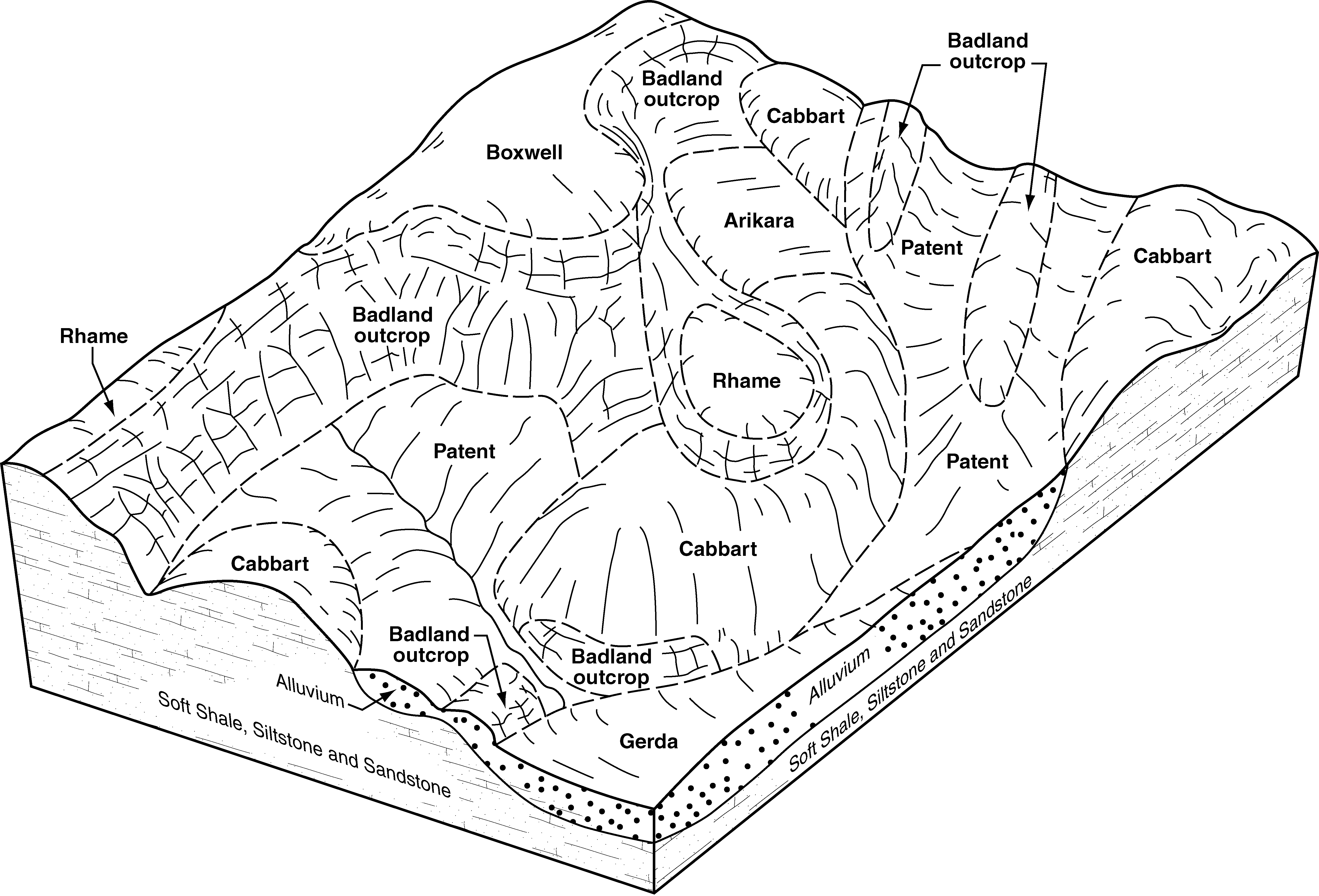
| Badland-Arikara-Cabbart complex, 15 to 70 percent slopes | L3191F | 41810 | 2707062 | 2q1x9 | nd007 | 1998 | 1:24000 |
Boxwell-Cabbart-Arikara complex, 9 to 70 percent slopes | L2633F | 17036 | 2707049 | 2q1xp | nd007 | 1998 | 1:24000 |
Lonna-Arikara-Cabbart complex, 9 to 70 percent slopes | L2631F | 10130 | 2707048 | 2qxkn | nd007 | 1998 | 1:24000 |
Maltese-Lonna-Arikara complex, 2 to 50 percent slopes | L2321F | 5089 | 2707045 | 2qxkd | nd007 | 1998 | 1:24000 |
Kirby-Arikara-Badland complex, 9 to 70 percent slopes | L3104F | 4391 | 2707057 | 2q2mz | nd007 | 1998 | 1:24000 |
Rhame-Arikara-Fleak complex, 9 to 70 percent slopes | L1661F | 4154 | 2707040 | 2qxhw | nd007 | 1998 | 1:24000 |
Arikara-Shambo-Cabba loams, 9 to 70 percent slopes | E2725F | 1162 | 2699062 | 1vztv | nd007 | 1998 | 1:24000 |
Shibah-Rubble land-Arikara complex, 15 to 70 percent slopes | L4506F | 417 | 2707082 | 2qxjs | nd007 | 1998 | 1:24000 |
Arikara-Cabbart loams, 15 to 70 percent slopes | L3199F | 10 | 2758440 | 2q1wy | nd007 | 1998 | 1:24000 |
Badland-Arikara-Cabbart complex, 15 to 70 percent slopes | L3191F | 119620 | 2707125 | 2q1x9 | nd025 | 1981 | 1:20000 |
Rhame-Arikara-Fleak complex, 9 to 70 percent slopes | L1661F | 14792 | 2707143 | 2qxhw | nd025 | 1981 | 1:20000 |
Arikara-Shambo-Cabba loams, 9 to 70 percent slopes | E2725F | 9912 | 1714645 | 1vztv | nd025 | 1981 | 1:20000 |
Cabba-Badland-Arikara complex, 9 to 70 percent slopes | E3103F | 7850 | 2707218 | 2qz6w | nd025 | 1981 | 1:20000 |
Arikara-Cabbart loams, 15 to 70 percent slopes | L3199F | 3685 | 2707124 | 2q1wy | nd025 | 1981 | 1:20000 |
Arikara-Cabba loams, 15 to 70 percent slopes | E3199F | 1156 | 2707223 | d1y4 | nd025 | 1981 | 1:20000 |
Zahl-Williams-Arikara loams, 9 to 45 percent slopes | E3569F | 395 | 2758488 | d1xz | nd025 | 1981 | 1:20000 |
Vebar-Arikara-Flasher complex, 9 to 50 percent slopes | E1661F | 121 | 2758473 | 1vzt0 | nd025 | 1981 | 1:20000 |
Boxwell-Cabbart-Arikara complex, 9 to 70 percent slopes | L2633F | 28 | 2758496 | 2q1xp | nd025 | 1981 | 1:20000 |
Zahl-Cabba-Arikara complex, 9 to 70 percent slopes | E3607F | 12 | 2758489 | cvsw | nd025 | 1981 | 1:20000 |
Badland-Arikara-Cabbart complex, 15 to 70 percent slopes | L3191F | 3544 | 2759770 | 2q1x9 | nd033 | 1985 | 1:24000 |
Arikara-Cabbart loams, 15 to 70 percent slopes | L3199F | 188 | 2759773 | 2q1wy | nd033 | 1985 | 1:24000 |
Lonna-Arikara-Cabbart complex, 9 to 70 percent slopes | L2631F | 155 | 2759762 | 2qxkn | nd033 | 1985 | 1:24000 |
Arikara-Shambo-Cabba loams, 9 to 70 percent slopes | E2725F | 61 | 2759741 | 1vztv | nd033 | 1985 | 1:24000 |
Boxwell-Cabbart-Arikara complex, 9 to 70 percent slopes | L2633F | 20 | 2759763 | 2q1xp | nd033 | 1985 | 1:24000 |
Shibah-Rubble land-Arikara complex, 15 to 70 percent slopes | L4506F | 13 | 2759777 | 2qxjs | nd033 | 1985 | 1:24000 |
Badland-Arikara-Cabbart complex, 15 to 70 percent slopes | L3191F | 80198 | 2715126 | 2q1x9 | nd053 | 2003 | 1:24000 |
Boxwell-Cabbart-Arikara complex, 9 to 70 percent slopes | L2633F | 34768 | 2715129 | 2q1xp | nd053 | 2003 | 1:24000 |
Zahl-Cabba-Arikara complex, 9 to 70 percent slopes | E3607F | 34262 | 2715120 | cvsw | nd053 | 2003 | 1:24000 |
Rhame-Arikara-Fleak complex, 9 to 70 percent slopes | L1661F | 19226 | 2715145 | 2qxhw | nd053 | 2003 | 1:24000 |
Arikara-Shambo-Cabba loams, 9 to 70 percent slopes | E2725F | 18436 | 2715079 | 1vztv | nd053 | 2003 | 1:24000 |
Cabba-Badland-Arikara complex, 9 to 70 percent slopes | E3103F | 9076 | 2715092 | 2qz6w | nd053 | 2003 | 1:24000 |
Maltese-Lonna-Arikara complex, 2 to 50 percent slopes | L2321F | 3646 | 2715148 | 2qxkd | nd053 | 2003 | 1:24000 |
Kirby-Arikara-Badland complex, 9 to 70 percent slopes | L3104F | 3362 | 2715135 | 2q2mz | nd053 | 2003 | 1:24000 |
Vebar-Arikara-Flasher complex, 9 to 50 percent slopes | E1661F | 3091 | 2715061 | 1vzt0 | nd053 | 2003 | 1:24000 |
Arikara-Cabbart loams, 15 to 70 percent slopes | L3199F | 2324 | 2715125 | 2q1wy | nd053 | 2003 | 1:24000 |
Zahl-Williams-Arikara loams, 9 to 45 percent slopes | E3569F | 2311 | 2715118 | d1xz | nd053 | 2003 | 1:24000 |
Arikara-Cabba loams, 15 to 70 percent slopes | E3199F | 598 | 2715097 | d1y4 | nd053 | 2003 | 1:24000 |
Arikara-Shambo-Cabba loams, 9 to 70 percent slopes | E2725F | 8064 | 1718355 | 1vztv | nd059 | 1998 | 1:20000 |
Vebar-Arikara-Flasher complex, 9 to 50 percent slopes | E1661F | 2407 | 1718347 | 1vzt0 | nd059 | 1998 | 1:20000 |
Arikara-Shambo-Cabba loams, 9 to 70 percent slopes | E2725F | 33894 | 2662519 | 1vztv | nd061 | 1988 | 1:24000 |
Boxwell-Cabbart-Arikara complex, 9 to 70 percent slopes | L2633F | 217 | 2758534 | 2q1xp | nd087 | 1974 | 1:20000 |
Arikara-Shambo-Cabba loams, 9 to 70 percent slopes | E2725F | 23568 | 1713531 | 1vztv | nd089 | 1965 | 1:20000 |
Vebar-Arikara-Flasher complex, 9 to 50 percent slopes | E1661F | 3303 | 1713505 | 1vzt0 | nd089 | 1965 | 1:20000 |
Arikara-Cabba loams, 15 to 70 percent slopes | E3199F | 70 | 2715998 | d1y4 | nd089 | 1965 | 1:20000 |
Arikara-Shambo-Cabba loams, 9 to 70 percent slopes | E2725F | 31 | 2662568 | 1vztv | nd105 | 1993 | 1:24000 |
