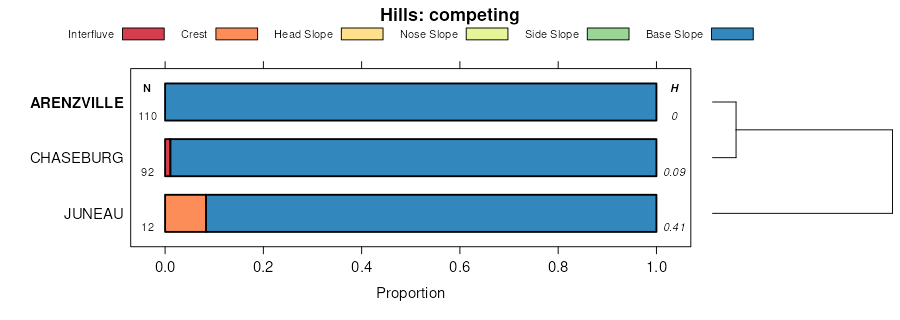
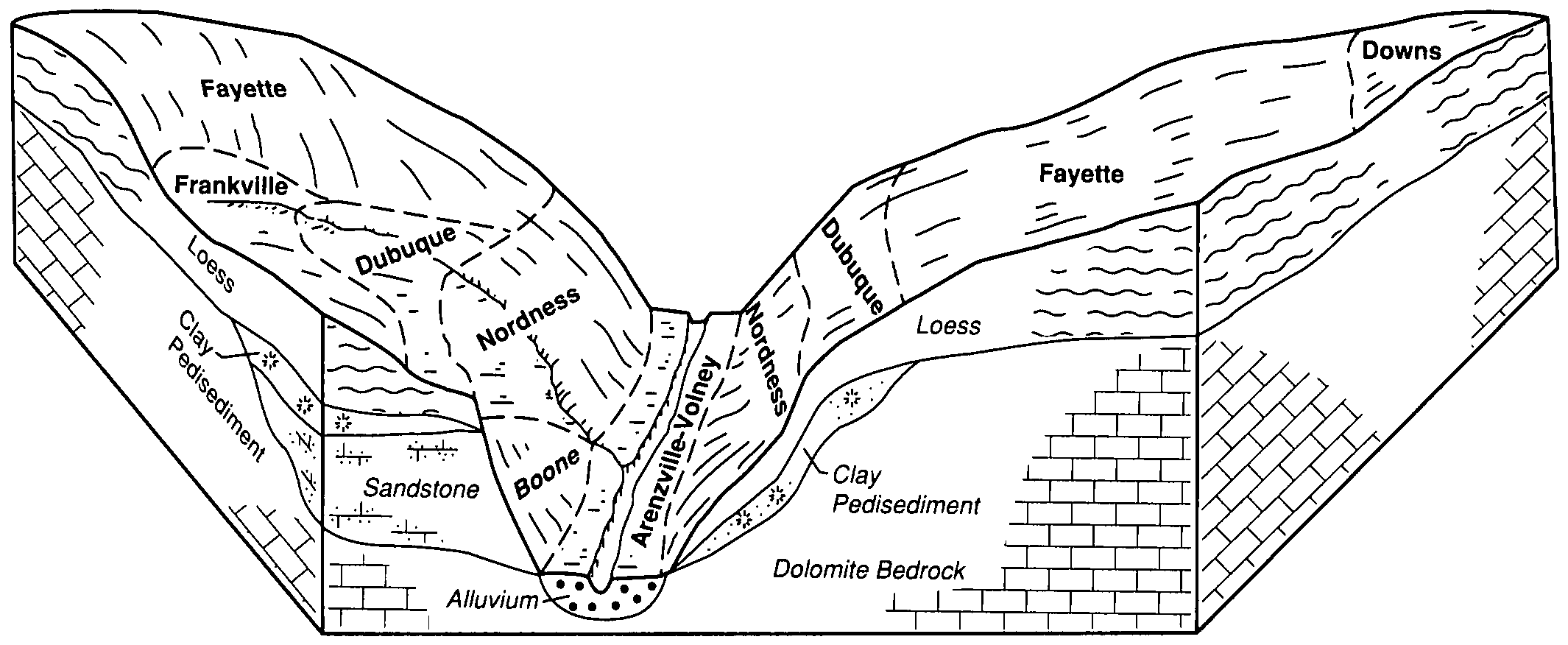
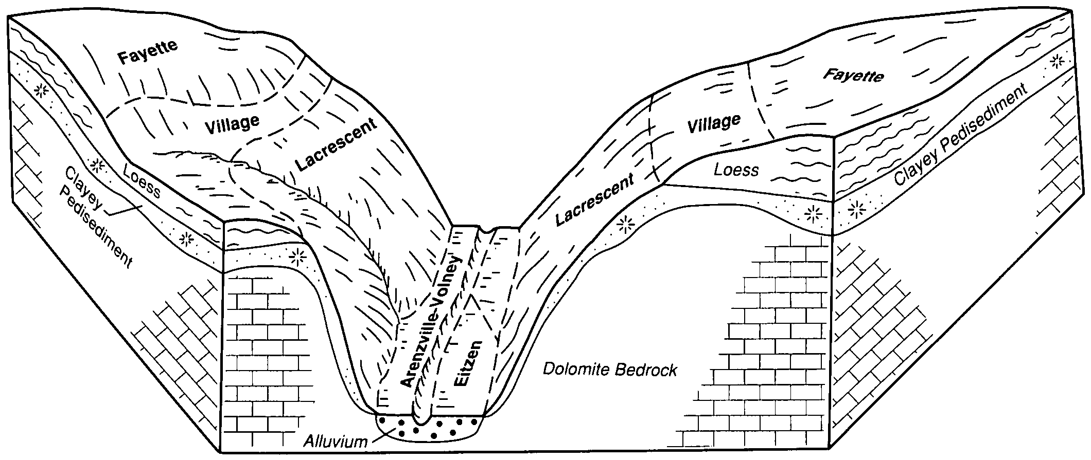
| Arenzville-Volney complex, 2 to 5 percent slopes | 1496B | 4558 | 402354 | fhp5 | ia005 | 1992 | 1:15840 |
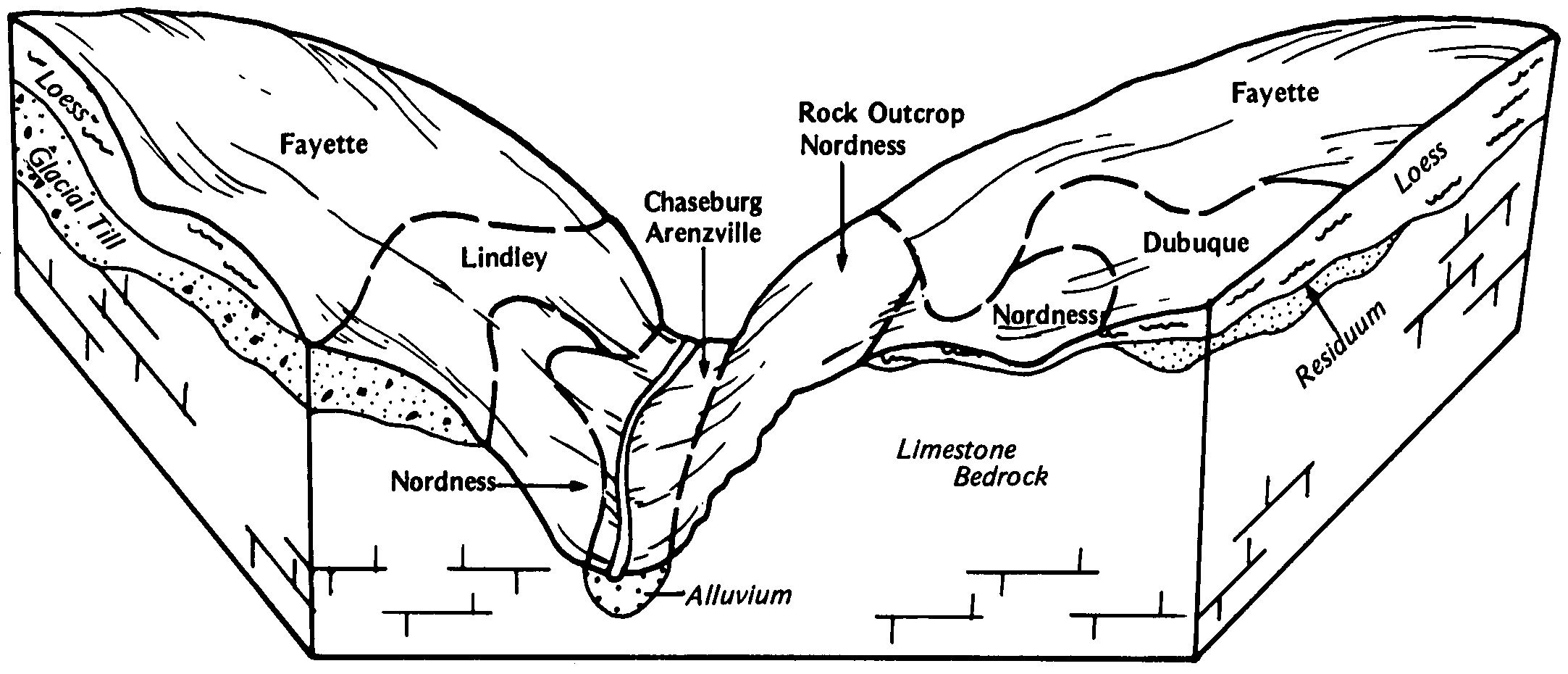
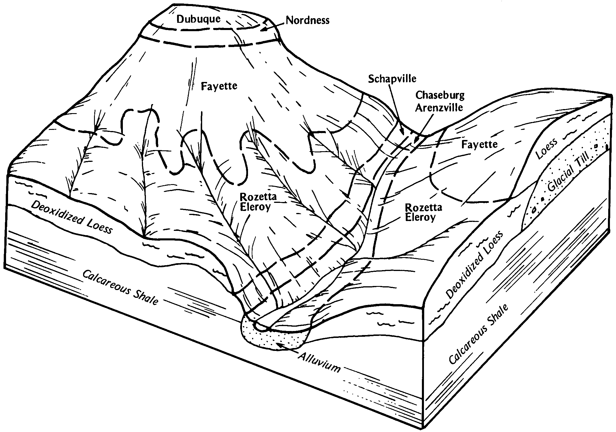
Arenzville-Chaseburg complex, 1 to 5 percent slopes | 129B | 1995 | 402345 | 2tc4l | ia005 | 1992 | 1:15840 |
Arenzville-Volney complex, 0 to 2 percent slopes | 1496 | 1760 | 402353 | fhp4 | ia005 | 1992 | 1:15840 |
Arenzville silt loam, 0 to 3 percent slopes, occasionally flooded | 320 | 1291 | 402431 | 2wtqs | ia005 | 1992 | 1:15840 |
Arenzville-Chaseburg complex, 1 to 5 percent slopes | 129B | 6112 | 404203 | 2tc4l | ia043 | 1979 | 1:15840 |
Arenzville silt loam, 0 to 3 percent slopes, occasionally flooded | 320 | 3383 | 404252 | 2wtqs | ia043 | 1979 | 1:15840 |
Arenzville-Chaseburg complex, 1 to 5 percent slopes | 129B | 13449 | 404348 | 2tc4l | ia045 | 1978 | 1:15840 |
Arenzville-Chaseburg complex, 1 to 5 percent slopes | 129B | 3134 | 404979 | 2tc4l | ia055 | 1984 | 1:15840 |
Arenzville-Chaseburg complex, 1 to 5 percent slopes | 129B | 12966 | 405375 | 2tc4l | ia061 | 1983 | 1:15840 |
Arenzville silt loam, 0 to 3 percent slopes, occasionally flooded | 320 | 5190 | 405417 | 2wtqs | ia061 | 1983 | 1:15840 |
Arenzville-Chaseburg complex, 1 to 5 percent slopes | 129B | 2167 | 405695 | 2tc4l | ia065 | 1975 | 1:15840 |
Arenzville-Chaseburg complex, 1 to 5 percent slopes | 129B | 9174 | 407450 | 2tc4l | ia097 | 1988 | 1:15840 |
Arenzville silt loam, 0 to 3 percent slopes, occasionally flooded | 320 | 2064 | 407494 | 2wtqs | ia097 | 1988 | 1:15840 |
Nodaway-Arenzville silt loams, 1 to 4 percent slopes | 729B | 9747 | 408042 | fpln | ia103 | 1979 | 1:15840 |
Arenzville silt loam, 0 to 2 percent slopes | 320 | 2529 | 408001 | fpkb | ia103 | 1979 | 1:15840 |
Arenzville-Chaseburg complex, 1 to 5 percent slopes | 129B | 12732 | 408086 | 2tc4l | ia105 | 1988 | 1:15840 |
Arenzville silt loam, 0 to 3 percent slopes, occasionally flooded | 320 | 3160 | 408139 | 2wtqs | ia105 | 1988 | 1:15840 |
Arenzville silt loam, 0 to 3 percent slopes, occasionally flooded | 320 | 648 | 437362 | 2wtqs | ia191 | 2005 | 1:12000 |
Arenzville silt loam, 0 to 2 percent slopes, frequently flooded | 3078A | 5128 | 731143 | sjt8 | il017 | 2003 | 1:12000 |
Arenzville silt loam, 0 to 2 percent slopes, rarely flooded | 7078A | 1623 | 1444920 | 1khkb | il017 | 2003 | 1:12000 |
Arenzville silt loam, 0 to 2 percent slopes, occasionally flooded | 8078A | 262 | 2650853 | 2rmm2 | il017 | 2003 | 1:12000 |
Arenzville silt loam, 0 to 2 percent slopes, occasionally flooded | 8078A | 375 | 198882 | 6nyk | il119 | 2001 | 1:12000 |
Arenzville silt loam, 0 to 2 percent slopes, occasionally flooded | 8078A | 844 | 177817 | 5z11 | il125 | 1989 | 1:15840 |
Arenzville silt loam, 0 to 2 percent slopes, frequently flooded | 3078A | 4962 | 1406318 | 1j6d3 | il129 | 2005 | 1:12000 |
Arenzville silt loam, 0 to 2 percent slopes, occasionally flooded | 8078A | 293 | 184128 | 65lm | il133 | 1998 | 1:12000 |
Arenzville silt loam, 0 to 2 percent slopes, frequently flooded | 3078A | 2293 | 1672176 | 1t415 | il137 | 1984 | 1:15840 |
Arenzville silt loam, 0 to 2 percent slopes, occasionally flooded | 8078A | 945 | 200564 | 6qpt | il157 | 2001 | 1:12000 |
Arenzville silt loam, 0 to 2 percent slopes, frequently flooded | 3078A | 2457 | 2542086 | 2qrcq | il171 | 1984 | 1:12000 |
Beavercreek-Arenzville complex, 1 to 12 percent slopes | 598B | 7700 | 398309 | fcgp | mn055 | 1981 | 1:15840 |
Arenzville silt loam, 0 to 3 percent slopes, occasionally flooded | 16 | 4252 | 398226 | 2wtqs | mn055 | 1981 | 1:15840 |
Arenzville silt loam, 0 to 3 percent slopes, occasionally flooded | 16 | 5589 | 400716 | 2wtqs | mn109 | 1977 | 1:15840 |
Arenzville silt loam, 0 to 3 percent slopes, occasionally flooded | Az | 3898 | 2216289 | 2wtqs | mn157 | 2008 | 1:12000 |
Arenzville silt loam, 0 to 3 percent slopes, occasionally flooded | 626A | 6648 | 2561673 | 2wtqs | wi011 | 1960 | 1:12000 |
Arenzville silt loam, 0 to 3 percent slopes, occasionally flooded | 626A | 1212 | 421484 | 2wtqs | wi017 | 1985 | 1:15840 |
Arenzville silt loam, 0 to 3 percent slopes, occasionally flooded | 626A | 7546 | 2499020 | 2wtqs | wi023 | 1960 | 1:12000 |
Arenzville silt loam, 0 to 3 percent slopes, occasionally flooded | 626A | 3903 | 2499021 | 2wtqs | wi033 | 2003 | 1:12000 |
Arenzville silt loam, 0 to 3 percent slopes, occasionally flooded | 626A | 4304 | 421740 | 2wtqs | wi035 | 1974 | 1:12000 |
Arenzville silt loam, 0 to 3 percent slopes, occasionally flooded | 626A | 38138 | 424134 | 2wtqs | wi043 | 1959 | 1:20000 |
Arenzville silt loam, 0 to 3 percent slopes, occasionally flooded | 626A | 3748 | 425196 | 2wtqs | wi045 | 1969 | 1:12000 |
Chaseburg and Arenzville silt loams, 0 to 2 percent slopes | 1616A | 794 | 425212 | 2tc4m | wi045 | 1969 | 1:12000 |
Arenzville silt loam, 0 to 3 percent slopes, occasionally flooded | 626A | 6388 | 2806641 | 2wtqs | wi049 | 1960 | 1:20000 |
Arenzville silt loam, 0 to 3 percent slopes, occasionally flooded | 626A | 1485 | 2499026 | 2wtqs | wi053 | 1994 | 1:12000 |
Arenzville silt loam, 0 to 3 percent slopes, occasionally flooded | 626A | 1 | 2561556 | 2wtqs | wi057 | 1987 | 1:12000 |
Arenzville silt loam, 0 to 3 percent slopes, occasionally flooded | 626A | 5662 | 2499022 | 2wtqs | wi063 | 2001 | 1:12000 |
Arenzville silt loam, channeled, 0 to 2 percent slopes, occasionally flooded | 625A | 2137 | 2518484 | 2wtqt | wi063 | 2001 | 1:12000 |
Arenzville silt loam, 0 to 3 percent slopes, occasionally flooded | 626A | 10565 | 424736 | 2wtqs | wi065 | 1964 | 1:15840 |
Arenzville silt loam, 0 to 3 percent slopes, occasionally flooded | 626A | 865 | 2685066 | 2wtqs | wi081 | 1981 | 1:12000 |
Arenzville silt loam, channeled, 0 to 2 percent slopes, occasionally flooded | 625A | 86 | 2685135 | 2wtqt | wi081 | 1981 | 1:12000 |
Arenzville silt loam, 0 to 3 percent slopes, occasionally flooded | 626A | 1694 | 2499023 | 2wtqs | wi091 | 1998 | 1:12000 |
Arenzville silt loam, 0 to 3 percent slopes, occasionally flooded | 626A | 3322 | 1691009 | 2wtqs | wi093 | 2006 | 1:12000 |
Arenzville silt loam, cobbly substratum, 1 to 3 percent slopes, occasionally flooded | 640B | 2381 | 1691186 | 1trtd | wi093 | 2006 | 1:12000 |
Arenzville silt loam, 0 to 3 percent slopes, occasionally flooded | 626A | 8828 | 2499024 | 2wtqs | wi103 | 2002 | 1:12000 |
Arenzville silt loam, 0 to 3 percent slopes, occasionally flooded | 626A | 2551 | 423114 | 2wtqs | wi111 | 1977 | 1:15840 |
Arenzville silt loam, 0 to 3 percent slopes, occasionally flooded | 626A | 1159 | 2683497 | 2wtqs | wi121 | 1969 | 1:12000 |
Arenzville silt loam, 0 to 3 percent slopes, occasionally flooded | 626A | 7531 | 2499025 | 2wtqs | wi123 | 1965 | 1:12000 |