| Angie-Wickham complex, 0 to 2 percent slopes | AwA | 3273 | 328485 | c0t9 | al021 | 1967 | 1:20000 |
Angie-Wickham complex, 2 to 6 percent slopes | AwB | 683 | 328486 | c0tb | al021 | 1967 | 1:20000 |
Shubuta and Angie very fine sandy loams, eroded, gently sloping | ScC2 | 12867 | 329037 | c1d3 | al045 | 1958 | 1:20000 |
Shubuta and Angie very fine sandy loams, eroded, very gently sloping | ScB2 | 8120 | 329035 | c1d1 | al045 | 1958 | 1:20000 |
Shubuta and Angie very fine sandy loams, eroded, sloping | ScD2 | 7586 | 329039 | c1d5 | al045 | 1958 | 1:20000 |
Shubuta and Angie sandy clay loams, severely eroded, gently sloping | SbC3 | 2059 | 329033 | c1cz | al045 | 1958 | 1:20000 |
Shubuta and Angie very fine sandy loams, sloping | ScD | 970 | 329038 | c1d4 | al045 | 1958 | 1:20000 |
Shubuta and Angie very fine sandy loams, very gently sloping | ScB | 766 | 329034 | c1d0 | al045 | 1958 | 1:20000 |
Shubuta and Angie sandy clay loams, severely eroded, very gently sloping | SbB3 | 584 | 329032 | c1cy | al045 | 1958 | 1:20000 |
Shubuta and Angie very fine sandy loams, gently sloping | ScC | 554 | 329036 | c1d2 | al045 | 1958 | 1:20000 |
Angie fine sandy loam, 2 to 5 percent slopes | 3 | 4456 | 329066 | c1f1 | al047 | 1977 | 1:20000 |
Angie fine sandy loam, 5 to 12 percent slopes | 4 | 3377 | 329077 | c1fd | al047 | 1977 | 1:20000 |
Angie fine sandy loam, 0 to 2 percent slopes | 2 | 2419 | 329055 | c1dp | al047 | 1977 | 1:20000 |
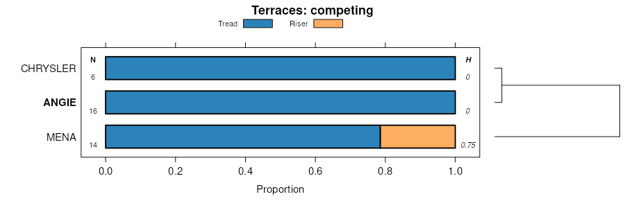
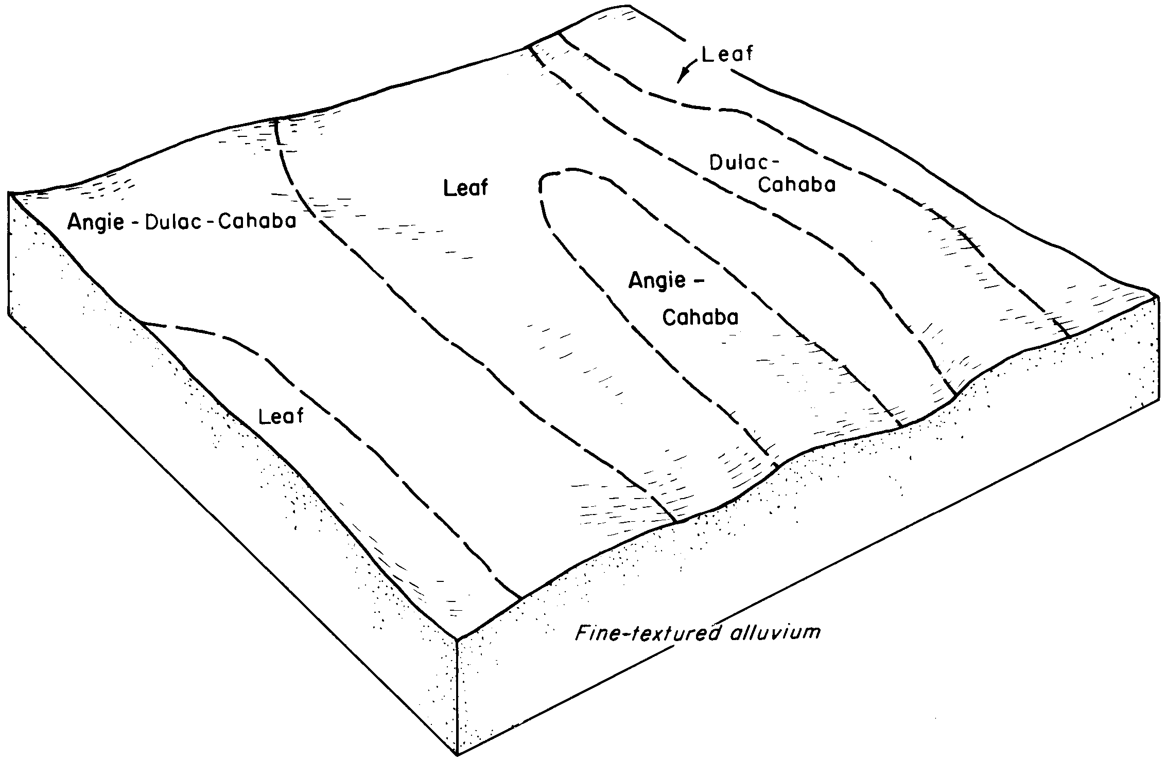
Leaf-Angie association | LF | 15739 | 329668 | c21g | al063 | 2013 | 1: |
Angie fine sandy loam, terrace, 0 to 2 percent slopes | AgA | 8680 | 329647 | c20s | al063 | 2013 | 1: |
Angie-Leaf association | AS | 4370 | 329644 | c20p | al063 | 2013 | 1: |
Angie fine sandy loam, 2 to 5 percent slopes | AfB | 2361 | 329645 | c20q | al063 | 2013 | 1: |
Angie fine sandy loam, 5 to 8 percent slopes, eroded | AfC2 | 1047 | 329646 | c20r | al063 | 2013 | 1: |
Angie sandy clay loam, 5 to 12 percent slopes, severely eroded | AnD3 | 803 | 329649 | c20v | al063 | 2013 | 1: |
Angie fine sandy loam, terrace, 2 to 5 percent slopes | AgB | 446 | 329648 | c20t | al063 | 2013 | 1: |
Angie silt loam, 0 to 1 percent slopes | AnA | 1277 | 565288 | 2ykhc | ar025 | 1965 | 1:15840 |
Angie silt loam, 1 to 3 percent slope | AnB | 446 | 565289 | 2xz2b | ar025 | 1965 | 1:15840 |
Angie fine sandy loam, 3 to 8 percent slopes | 4 | 18293 | 565369 | 2xz22 | ar027 | 1983 | 1:20000 |
Angie fine sandy loam, 1 to 3 percent slopes | 3 | 9894 | 565366 | lz9m | ar027 | 1983 | 1:20000 |
Angie silt loam, 1 to 3 percent slopes | AnB | 6007 | 565686 | lzmy | ar061 | 1970 | 1:24000 |
Angie silt loam, 3 to 8 percent slopes | AnC | 3120 | 565687 | lzmz | ar061 | 1970 | 1:24000 |
Angie fine sandy loam, 1 to 8 percent slopes | AnC | 64 | 721485 | s6rq | ar099 | 2000 | 1:24000 |
Angie fine sandy loam, 3 to 8 percent slopes | 5 | 1435 | 566245 | 2xz22 | ar125 | 1976 | 1:20000 |
Angie fine sandy loam, 1 to 8 percent slopes | AnC | 713 | 579187 | mfpg | ar139 | 1992 | 1:24000 |
Angie fine sandy loam | 3 | 1420 | 1017236 | 134j2 | fl059 | 1971 | 1:12000 |
Bonifay-Dothan-Angie complex, 5 to 12 percent slopes | 49 | 11920 | 1444731 | 1khc7 | fl091 | 1989 | 1:20000 |
Angie sandy loam, 2 to 5 percent slopes | 35 | 1360 | 1444717 | 2w4g4 | fl091 | 1989 | 1:20000 |
Angie variant loam | 2 | 1700 | 823749 | wn5k | fl113 | 1978 | 1:20000 |
Bonneau-Norfolk-Angie complex, 5 to 12 percent slopes | 38 | 20210 | 324008 | bw4w | fl131 | 1985 | 1:20000 |
Angie sandy loam, 2 to 5 percent slopes | 37 | 1960 | 324007 | 2w4g4 | fl131 | 1985 | 1:20000 |
Angie fine sandy loam, frequently flooded | Au | 11743 | 125336 | 46f3 | ga609 | 1967 | 1:20000 |
Angie fine sandy loam | Av | 4435 | 326024 | by7x | ga646 | 1971 | 1:20000 |
Angie very fine sandy loam, 1 to 3 percent slopes | AnB | 4 | 2400534 | 2ynxp | la013 | 1992 | 1:24000 |
Angie very fine sandy loam, 1 to 3 percent slopes | An | 7863 | 569310 | 2ynxp | la027 | 1986 | 1:20000 |
Angie very fine sandy loam, 1 to 3 percent slopes | AnB | 8330 | 571109 | 2ynxp | la061 | 1991 | 1:24000 |
Angie very fine sandy loam, 1 to 5 percent slopes | An | 5980 | 1725322 | 1vxbk | la111 | 1992 | 1:24000 |
Angie very fine sandy loam, 1 to 5 percent slopes | AnC | 614 | 1725528 | 1vxk6 | la115 | 1992 | 1:24000 |
Angie silt loam, 1 to 5 percent slopes | Ag | 1029 | 1724137 | 1vw3b | la117 | 1989 | 1:24000 |
Angie fine sandy loam, 5 to 8 percent slopes, eroded | AnC2 | 2778 | 331967 | c4fm | ms023 | 1963 | 1:15840 |
Angie fine sandy loam, 2 to 5 percent slopes | AnB | 1510 | 331966 | c4fl | ms023 | 1963 | 1:15840 |
Angie fine sandy loam, 0 to 2 percent slopes | AnA | 271 | 331965 | c4fk | ms023 | 1963 | 1:15840 |
Angie silt loam, 0 to 2 percent slopes | AnA | 1184 | 332250 | c4qr | ms039 | 1967 | 1:20000 |
Angie fine sandy loam, 0 to 2 percent slopes | AgA | 513 | 2642152 | 2rrx9 | ms041 | 2012 | 1:24000 |
Angie fine sandy loam, 0 to 2 percent slopes | AnA | 1465 | 131733 | 4f2g | sc615 | 1981 | 1:20000 |
Angie fine sandy loam | An | 1821 | 575566 | m9xn | tx339 | 1967 | 1:20000 |
Angie loam, 0 to 2 percent slopes | AgA | 3211 | 119192 | 400x | va087 | 1973 | 1:15840 |
Angie loam, 2 to 6 percent slopes | AgB | 813 | 119193 | 400y | va087 | 1973 | 1:15840 |
Angie loam, 2 to 6 percent slopes, eroded | AgB2 | 463 | 119194 | 400z | va087 | 1973 | 1:15840 |
Angie loam, 6 to 10 percent slopes, eroded | AgC2 | 405 | 119195 | 4010 | va087 | 1973 | 1:15840 |
Angie loam, 10 to 25 percent slopes, eroded | AgE2 | 234 | 119196 | 4011 | va087 | 1973 | 1:15840 |
Angie loam, concretionary subsoil variant | Ak | 217 | 119197 | 4012 | va087 | 1973 | 1:15840 |
