Official Series Description


Lab Data Summary

Aggregate lab data for the ANDOVER soil series. This aggregation is based on all pedons with a current taxon name of ANDOVER, and applied along 1-cm thick depth slices. Solid lines are the slice-wise median, bounded on either side by the interval defined by the slice-wise 5th and 95th percentiles. The median is the value that splits the data in half. Five percent of the data are less than the 5th percentile, and five percent of the data are greater than the 95th percentile. Values along the right hand side y-axis describe the proportion of pedon data that contribute to aggregate values at this depth. For example, a value of "90%" at 25cm means that 90% of the pedons correlated to ANDOVER were used in the calculation. Source: KSSL snapshot . Methods used to assemble the KSSL snapshot used by SoilWeb / SDE

Click the image to view it full size.

Pedons used in the lab summary:

MLRALab IDPedon IDTaxonnameCINSSL / NASIS ReportsLink To SoilWeb GMap
12788PA0270911988PA027091Andover5Primary | Supplementary | Taxonomy | Pedon | Water Retention | Correlation | Andic Soil Properties41.0883333,-77.8925
12717N0046S2016MD023001Andover6Primary | Supplementary | Taxonomy | Pedon | Water Retention | Correlation | Andic Soil Properties39.5701667,-79.2536111
14758PA0350121958PA035012Andover5Primary | Supplementary | Taxonomy | Pedon | Water Retention | Correlation | Andic Soil Properties41.0466667,-77.21
14758PA0350131958PA035013Andover5Primary | Supplementary | Taxonomy | Pedon | Water Retention | Correlation | Andic Soil Properties41.0855556,-77.3863889
14777PA0610321977PA061032Andover4Primary | Supplementary | Taxonomy | Pedon | Water Retention | Correlation | Andic Soil Properties40.6888889,-77.9361111
14777PA0610341977PA061034Andover3Primary | Supplementary | Taxonomy | Pedon | Water Retention | Correlation | Andic Soil Properties40.6863889,-77.9369444
14781PA0270641981PA027064Andover4Primary | Supplementary | Taxonomy | Pedon | Water Retention | Correlation | Andic Soil Properties40.7858333,-77.6480556
14781PA0610351981PA061035Andover4Primary | Supplementary | Taxonomy | Pedon | Water Retention | Correlation | Andic Soil Properties40.4830556,-77.8541667
14788PA0550641988PA055064Andover5Primary | Supplementary | Taxonomy | Pedon | Water Retention | Correlation | Andic Soil Properties40.2252778,-77.6936111

Water Balance

Monthly water balance estimated using a leaky-bucket style model for the ANDOVER soil series. Monthly precipitation (PPT) and potential evapotranspiration (PET) have been estimated from the 50th percentile of gridded values (PRISM 1981-2010) overlapping with the extent of SSURGO map units containing each series as a major component. Monthly PET values were estimated using the method of Thornthwaite (1948). These (and other) climatic parameters are calculated with each SSURGO refresh and provided by the fetchOSD function of the soilDB package. Representative water storage values (“AWC” in the figures) were derived from SSURGO by taking the 50th percentile of profile-total water storage (sum[awc_r * horizon thickness]) for each soil series. Note that this representation of “water storage” is based on the average ability of most plants to extract soil water between 15 bar (“permanent wilting point”) and 1/3 bar (“field capacity”) matric potential. Soil moisture state can be roughly interpreted as “dry” when storage is depleted, “moist” when storage is between 0mm and AWC, and “wet” when there is a surplus. Clearly there are a lot of assumptions baked into this kind of monthly water balance. This is still a work in progress.

Click the image to view it full size.


Click the image to view it full size.

Sibling Summary

Siblings are those soil series that occur together in map units, in this case with the ANDOVER series. Sketches are arranged according to their subgroup-level taxonomic structure. Source: SSURGO snapshot , parsed OSD records and snapshot of SC database .

Click the image to view it full size.

Select annual climate data summaries for the ANDOVER series and siblings. Series are sorted according to hierarchical clustering of median values. Source: SSURGO map unit geometry and 1981-2010, 800m PRISM data .

Click the image to view it full size.

Geomorphic description summaries for the ANDOVER series and siblings. Series are sorted according to hierarchical clustering of proportions and relative hydrologic position within an idealized landform (e.g. top to bottom). Most soil series (SSURGO components) are associated with a hillslope position and one or more landform-specific positions: hills, mountain slopes, terraces, and/or flats. Proportions can be interpreted as an aggregate representation of geomorphic membership. The values printed to the left (number of component records) and right (Shannon entropy) of stacked bars can be used to judge the reliability of trends. Small Shannon entropy values suggest relatively consistent geomorphic association, while larger values suggest lack thereof. Source: SSURGO component records .

Click the image to view it full size.

Click the image to view it full size.

Click the image to view it full size.

Click the image to view it full size.

Click the image to view it full size.

Competing Series

Soil series competing with ANDOVER share the same family level classification in Soil Taxonomy. Source: parsed OSD records and snapshot of the SC database .

Click the image to view it full size.

Select annual climate data summaries for the ANDOVER series and competing. Series are sorted according to hierarchical clustering of median values. Source: SSURGO map unit geometry and 1981-2010, 800m PRISM data .

Click the image to view it full size.

Geomorphic description summaries for the ANDOVER series and competing. Series are sorted according to hierarchical clustering of proportions and relative hydrologic position within an idealized landform (e.g. top to bottom). Proportions can be interpreted as an aggregate representation of geomorphic membership. Most soil series (SSURGO components) are associated with a hillslope position and one or more landform-specific positions: hills, mountain slopes, terraces, and/or flats. The values printed to the left (number of component records) and right (Shannon entropy) of stacked bars can be used to judge the reliability of trends. Shannon entropy values close to 0 represent soil series with relatively consistent geomorphic association, while values close to 1 suggest lack thereof. Source: SSURGO component records .

Click the image to view it full size.

Click the image to view it full size.

There are insufficient data to create the 3D mountains figure.

There are insufficient data to create the 3D terrace figure.

There are insufficient data to create the 3D flats position figure.

Soil series sharing subgroup-level classification with ANDOVER, arranged according to family differentiae. Hovering over a series name will print full classification and a small sketch from the OSD. Source: snapshot of SC database .

Block Diagrams

Click a link below to display the diagram. Note that these diagrams may be from multiple survey areas.

  1. MD-2010-09-07-10 | Washington County - 2003

    Relationship of soils to topography and underlying material in the Dekalb-Sideling-Hazleton general soil map unit (Soil Survey of Washington County, Maryland; 2003).

  2. MD-2012-02-03-29 | Washington County - 2003

    Relationship of soils to topography and underlying material in the Dekalb-Sideling-Hazleton general soil map unit (Soil Survey of Washington County, Maryland; 2003).

  3. PA-2010-09-30-06 | Clinton County - 2007

    Typical pattern of soils and parent material throughout the Susquehanna Lowland Section (Soil Survey of Clinton County, Pennsylvania; 2007).

  4. PA-2010-09-30-07 | Clinton County - 2007

    Typical pattern of soils and parent material on the side slopes and footslopes of the Appalachian Mountain Section (Soil Survey of Clinton County, Pennsylvania; 2007).

  5. PA-2010-09-30-09 | Clinton County - 2007

    Typical pattern of soils and parent material throughout the Deep Valleys Section (Soil Survey of Clinton County, Pennsylvania; 2007).

  6. PA-2010-09-30-14 | Fulton County - 2004

    Relationship of soils to topography and the underlying material in the Laidig-Buchanan general soil map unit (Soil Survey of Fulton County, Pennsylvania; 2004).

  7. PA-2012-03-12-10 | Bedford County - 1998

    Typical pattern of soils and underlying material in the Buchanan-Dystrochrepts-Meckesville general soil map unit (Soil Survey of Bedford County, PA; 1998).

  8. PA-2012-03-12-15 | Berks County - September 1970

    Cross section of the northern part of Berks County showing soils of associations 1, 2, and 3 (Soil Survey of berks County, PA; 1970).

  9. PA-2012-03-12-17 | Blair County - October 1981

    Typical pattern of soils and underlying material in the Laidig-Hazleton-Buchanan association (Soil Survey of Blair County, PA; 1981).

  10. PA-2012-03-13-07 | Centre County - August 1981

    Typical pattern of soils and underlying material in association 1 (Soil Survey of Centre County, PA; 1981).

  11. PA-2012-03-13-11 | Centre County - August 1981

    Typical pattern of soils and underlying material in association 10 (Soil Survey of Centre County, PA; 1981).

  12. PA-2012-03-13-19 | Cumberland and Perry Counties - April 1986

    Typical pattern of soils and underlying material in the Hazleton-Laidig-Buchanan association (Soil Survey of Cumberland and Perry Counties, PA; 1986).

  13. PA-2012-03-13-20 | Cumberland and Perry Counties - April 1986

    Typical pattern of soils and underlying material in the Murrill-Laidig-Buchanan association (Soil Survey of Cumberland and Perry Counties, PA; 1986).

  14. PA-2012-03-13-21 | Cumberland and Perry Counties - April 1986

    Typical pattern of soils and underlying material in the Hazleton-Clymer association (Soil Survey of Cumberland and Perry Counties, PA; 1986).

  15. PA-2012-03-13-26 | Franklin County - August 1975

    Relationship of underlying material and topography in association 1 (Soil Survey of Franklin County, PA; 1975).

  16. PA-2012-03-13-31 | Franklin County - August 1975

    Relationship of underlying material and topography in association 6 (Soil Survey of Franklin County, PA; 1975).

  17. PA-2012-03-13-39 | Juniata and Mifflin Counties - April 1981

    Typical pattern of soils and underlying material of the Hazleton-Laidig-Buchanan association (Soil Survey of Juniata and Mifflin Counties, PA; 1981).

  18. PA-2012-03-14-02 | Northampton County - July 1974

    Typical pattern of soils and underlying material in association 2 (Soil Survey of Northampton County, PA; 1974).

Map Units

Map units containing ANDOVER as a major component. Limited to 250 records.

Map Unit Name Symbol Map Unit Area (ac) Map Unit Key National Map Unit Symbol Soil Survey Area Publication Date Map Scale
Brinkerton and Andover very stony silt loams, 0 to 15 percent slopesBsC11000532893kwj3md02319701:20000
Brinkerton and Andover silt loams, 0 to 3 percent slopesBrA7520532891kwj1md02319701:20000
Brinkerton and Andover silt loams, 3 to 8 percent slopesBrB3280532892kwj2md02319701:20000
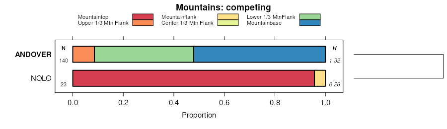
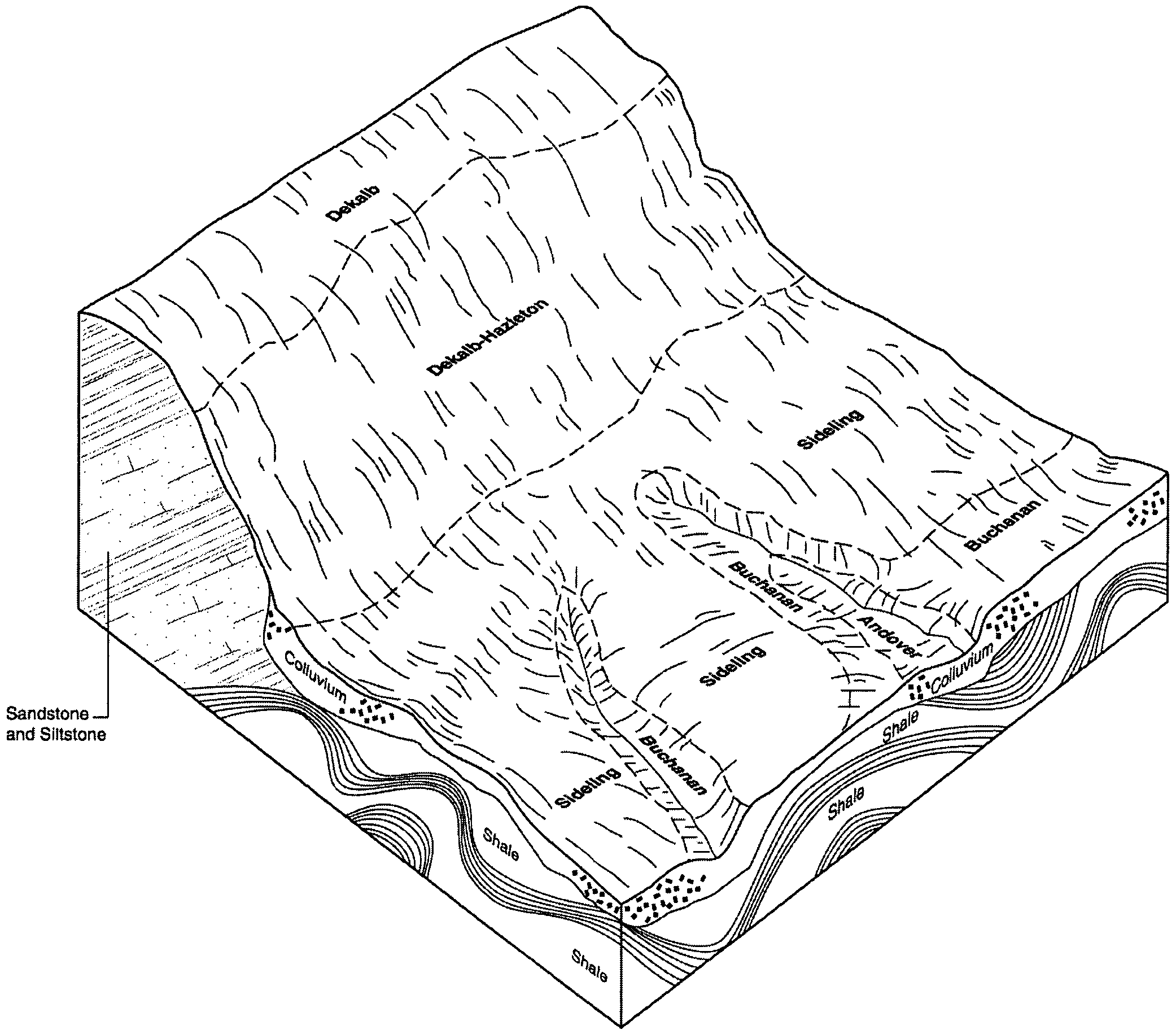
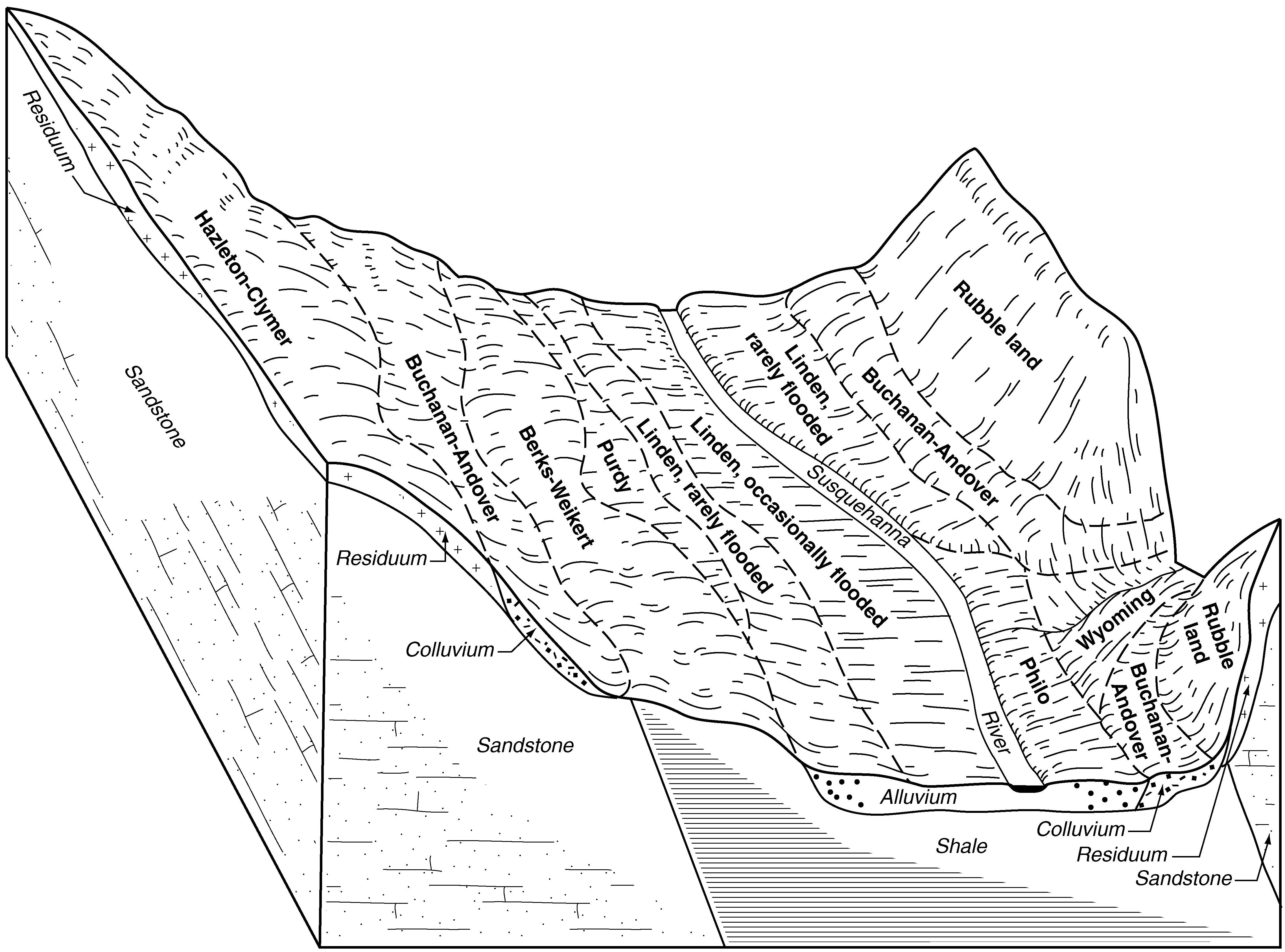
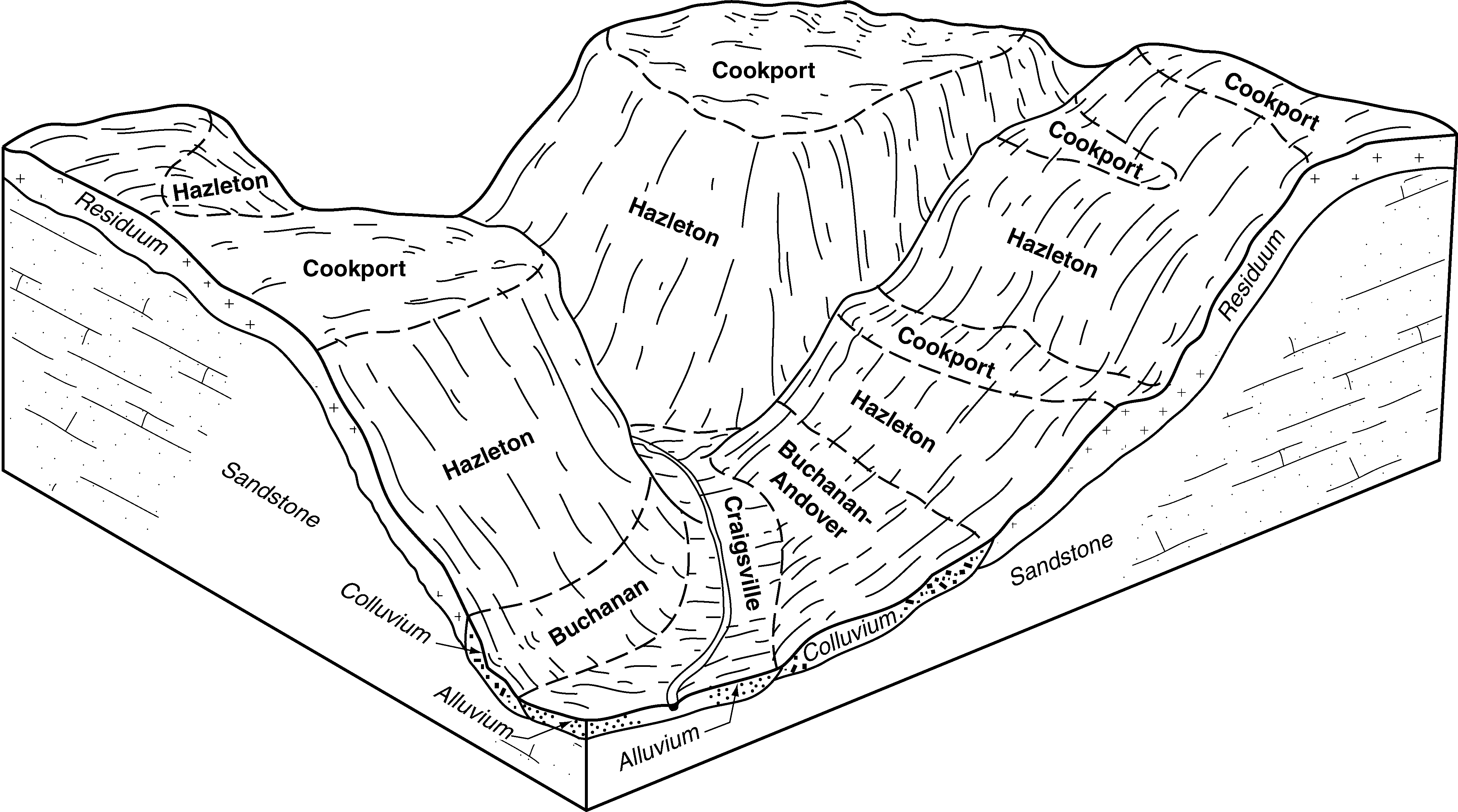
Andover-Buchanan loams, 0 to 8 percent slopes, very stonyAnB276534129kxszmd04319981:12000
Andover cobbly sandy loam, 0 to 8 percent slopes, very stonyAvB2567541754l5qypa00919891:24000
Andover cobbly loam, 3 to 8 percent slopesArB2045541752l5qwpa00919891:24000
Andover cobbly sandy loam, 8 to 15 percent slopes, very stonyAvC602541755l5qzpa00919891:24000
Andover cobbly loam, 8 to 15 percent slopesArC565541753l5qxpa00919891:24000
Andover-Buchanan gravelly loams, 3 to 8 percent slopesAnB2347542967l702pa01119971:24000
Andover-Buchanan gravelly loams, 0 to 8 percent slopes, extremely stonyAoB1312542968l703pa01119971:24000
Andover-Buchanan gravelly loams, 0 to 3 percent slopesAnA219542966l701pa01119971:24000
Andover variant extremely stony loam, 3 to 8 percent slopesAoB1197542316l6b2pa01319781:20000
Andover variant loam, 3 to 8 percent slopesAnB480542315l6b1pa01319781:20000
Andover loam, 3 to 8 percent slopesAnB3132538138l1z9pa01919841:15840
Andover loam, 0 to 8 percent slopes, extremely stonyAoB2080538140l1zcpa01919841:15840
Andover loam, 8 to 15 percent slopes, extremely stonyAoC1726538141l1zdpa01919841:15840
Andover loam, 0 to 3 percent slopesAnA1013538137l1z8pa01919841:15840
Andover loam, 8 to 15 percent slopesAnC723538139l1zbpa01919841:15840
Andover very stony loam, 0 to 3 percent slopesAvA600539298l35qpa02519601:20000
Andover very stony loam, 8 to 15 percent slopesAoC13160538239l22kpa02719751:20000
Andover very stony loam, 0 to 8 percent slopesAoB7014538238l22jpa02719751:20000
Andover channery silt loam, 0 to 8 percent slopesAnB6371538236l22gpa02719751:20000
Andover channery silt loam, 8 to 15 percent slopesAnC4339538237l22hpa02719751:20000
Buchanan-Andover gravelly loams, 8 to 15 percent slopesBuC5777543919l7zspa03520021:24000
Buchanan-Andover gravelly loams, 3 to 8 percent slopesBuB5528543916l7zppa03520021:24000
Buchanan-Andover gravelly loams, 0 to 8 percent slopes, extremely stonyBxB1254543925l7zzpa03520021:24000
Buchanan-Andover gravelly loams, 8 to 25 percent slopes, extremely stonyBxC1021543926l800pa03520021:24000
Andover very stony loam, 0 to 8 percent slopesAoB3350693674r8tlpa04119801:15840
Andover gravelly loam, 0 to 8 percent slopesAnB998693673r8tkpa04119801:15840
Andover very stony loam, 0 to 8 percent slopesAoB1190540692l4mppa04319671:15840
Andover gravelly loam, 3 to 8 percent slopesAnB300540691l4mnpa04319671:15840
Andover gravelly loam, 0 to 8 percent slopes, extremely stonyAogB59737594srjcpa04319671:15840
Andover gravelly loam, 0 to 8 percent slopes, very stonyAnB187615911811qdrfpa05120051:24000
Andover gravelly loam, 3 to 8 percent slopesAnB3222545061l95mpa05519991:24000
Andover gravelly loam, 0 to 8 percent slopes, very stonyAoB1727545063l95ppa05519991:24000
Andover gravelly loam, 0 to 8 percent slopes, very stonyAoB1068544804l8xbpa05719991:24000
Andover gravelly loam, 3 to 8 percent slopesAnB586544802l8x8pa05719991:24000
Andover extremely stony loam, 0 to 8 percent slopesAoB9265541952l5ybpa06119741:20000
Andover cobbly loam, 0 to 8 percent slopesAnB1859541951l5y9pa06119741:20000
Andover gravelly loam, 3 to 8 percent slopesAngB7813976681hxd2pa07519761:20000
Andover gravelly loam, 0 to 8 percent slopes, extremely stonyAogB5313976691hxd3pa07519761:20000
Andover-Buchanan gravelly loams, 0 to 8 percent slopes, extremely stonyAoB567543102l74fpa07719971:24000
Andover-Buchanan gravelly loams, 3 to 8 percent slopesAnB77543101l74dpa07719971:24000
Andover-Buchanan gravelly loams, 0 to 3 percent slopesAnA41543100l74cpa07719971:24000
Buchanan-Andover gravelly loams, 3 to 8 percent slopesBtB311020155137k7pa08119811:20000
Andover-Buchanan gravelly loams, 3 to 8 percent slopesAnB1106543221l788pa09520071:12000
Andover-Buchanan gravelly loams, 0 to 8 percent slopes, extremely stonyAoB932543222l789pa09520071:12000
Andover-Buchanan gravelly loams, 0 to 3 percent slopesAnA479543220l787pa09520071:12000
Andover very stony loam, 0 to 8 percent slopesAoB3081693899r91vpa09919801:15840
Andover gravelly loam, 0 to 8 percent slopesAnB215693898r91tpa09919801:15840
Andover extremely stony loam, 0 to 8 percent slopesArB4068539697l3llpa10719771:20000
Andover gravelly loam, 3 to 8 percent slopesAnB277539696l3lkpa10719771:20000
Andover gravelly loam, 0 to 3 percent slopesAnA142539695l3ljpa10719771:20000
Andover extremely stony loam, 0 to 8 percent slopesAxB219540864l4t7pa10919801:20000
Andover gravelly loam, 2 to 8 percent slopesAvB9540870l4tfpa10919801:20000
Andover extremely stony loam, 0 to 8 percent slopesAoB10088545452l9l7pa60519751:20000
Andover extremely stony loam, 8 to 15 percent slopesAoC2964545453l9l8pa60519751:20000
Andover gravelly loam, 2 to 8 percent slopesAnB2843545451l9l6pa60519751:20000
Andover gravelly loam, 3 to 8 percent slopesAnB48555689ln7gwv06520031:24000
Andover and Brinkerton very stony soils, 3 to 8 percent slopesArB1591555858lndxwv60819731:20000
Andover fine sandy loam, 3 to 8 percent slopesAnB10732446892zf7hwv62819801:20000
Andover fine sandy loam, 8 to 15 percent slopesAnC532446902zf7jwv62819801:20000

Map of Series Extent

Approximate geographic distribution of the ANDOVER soil series. To learn more about how this distribution was mapped, or to compare this soil series extent to others, use the Series Extent Explorer (SEE) application. Source: generalization of SSURGO geometry .