Official Series Description


Lab Data Summary

Aggregate lab data for the AMENIA soil series. This aggregation is based on all pedons with a current taxon name of AMENIA, and applied along 1-cm thick depth slices. Solid lines are the slice-wise median, bounded on either side by the interval defined by the slice-wise 5th and 95th percentiles. The median is the value that splits the data in half. Five percent of the data are less than the 5th percentile, and five percent of the data are greater than the 95th percentile. Values along the right hand side y-axis describe the proportion of pedon data that contribute to aggregate values at this depth. For example, a value of "90%" at 25cm means that 90% of the pedons correlated to AMENIA were used in the calculation. Source: KSSL snapshot . Methods used to assemble the KSSL snapshot used by SoilWeb / SDE

Click the image to view it full size.

Pedons used in the lab summary:

MLRALab IDPedon IDTaxonnameCINSSL / NASIS ReportsLink To SoilWeb GMap
14283P010982VT021002Amenia7Primary | Supplementary | Taxonomy | Pedon | Water Retention | Correlation | Andic Soil Properties43.8411102,-73.0999985
14240A0293S1957NY049002Amenia6Primary | Supplementary | Taxonomy | Pedon | Water Retention | Correlation | Andic Soil Properties43.8702774,-75.5488892
144A83P01111982VT021004Amenia7Primary | Supplementary | Taxonomy | Pedon | Water Retention | Correlation | Andic Soil Properties43.476387,-73.043335
144A83P011382VT021005Amenia7Primary | Supplementary | Taxonomy | Pedon | Water Retention | Correlation | Andic Soil Properties43.4833336,-73.0438919
144B40A042260MA003003Amenia7Primary | Supplementary | Taxonomy | Pedon | Water Retention | Correlation | Andic Soil Properties42.401371,-73.3295364
144B99P055699CT005003Amenia7Primary | Supplementary | Taxonomy | Pedon | Water Retention | Correlation | Andic Soil Properties41.9719315,-73.2731476
144B40A0423S1960MA003004Amenia7Primary | Supplementary | Taxonomy | Pedon | Water Retention | Correlation | Andic Soil Properties42.3902588,-73.3523178

Water Balance

Monthly water balance estimated using a leaky-bucket style model for the AMENIA soil series. Monthly precipitation (PPT) and potential evapotranspiration (PET) have been estimated from the 50th percentile of gridded values (PRISM 1981-2010) overlapping with the extent of SSURGO map units containing each series as a major component. Monthly PET values were estimated using the method of Thornthwaite (1948). These (and other) climatic parameters are calculated with each SSURGO refresh and provided by the fetchOSD function of the soilDB package. Representative water storage values (“AWC” in the figures) were derived from SSURGO by taking the 50th percentile of profile-total water storage (sum[awc_r * horizon thickness]) for each soil series. Note that this representation of “water storage” is based on the average ability of most plants to extract soil water between 15 bar (“permanent wilting point”) and 1/3 bar (“field capacity”) matric potential. Soil moisture state can be roughly interpreted as “dry” when storage is depleted, “moist” when storage is between 0mm and AWC, and “wet” when there is a surplus. Clearly there are a lot of assumptions baked into this kind of monthly water balance. This is still a work in progress.

Click the image to view it full size.


Click the image to view it full size.

Sibling Summary

Siblings are those soil series that occur together in map units, in this case with the AMENIA series. Sketches are arranged according to their subgroup-level taxonomic structure. Source: SSURGO snapshot , parsed OSD records and snapshot of SC database .

Click the image to view it full size.

Select annual climate data summaries for the AMENIA series and siblings. Series are sorted according to hierarchical clustering of median values. Source: SSURGO map unit geometry and 1981-2010, 800m PRISM data .

Click the image to view it full size.

Geomorphic description summaries for the AMENIA series and siblings. Series are sorted according to hierarchical clustering of proportions and relative hydrologic position within an idealized landform (e.g. top to bottom). Most soil series (SSURGO components) are associated with a hillslope position and one or more landform-specific positions: hills, mountain slopes, terraces, and/or flats. Proportions can be interpreted as an aggregate representation of geomorphic membership. The values printed to the left (number of component records) and right (Shannon entropy) of stacked bars can be used to judge the reliability of trends. Small Shannon entropy values suggest relatively consistent geomorphic association, while larger values suggest lack thereof. Source: SSURGO component records .

Click the image to view it full size.

Click the image to view it full size.

There are insufficient data to create the 3D mountains figure.

Click the image to view it full size.

Click the image to view it full size.

Competing Series

Soil series competing with AMENIA share the same family level classification in Soil Taxonomy. Source: parsed OSD records and snapshot of the SC database .

Click the image to view it full size.

Select annual climate data summaries for the AMENIA series and competing. Series are sorted according to hierarchical clustering of median values. Source: SSURGO map unit geometry and 1981-2010, 800m PRISM data .

There are insufficient data to create the annual climate figure.

Geomorphic description summaries for the AMENIA series and competing. Series are sorted according to hierarchical clustering of proportions and relative hydrologic position within an idealized landform (e.g. top to bottom). Proportions can be interpreted as an aggregate representation of geomorphic membership. Most soil series (SSURGO components) are associated with a hillslope position and one or more landform-specific positions: hills, mountain slopes, terraces, and/or flats. The values printed to the left (number of component records) and right (Shannon entropy) of stacked bars can be used to judge the reliability of trends. Shannon entropy values close to 0 represent soil series with relatively consistent geomorphic association, while values close to 1 suggest lack thereof. Source: SSURGO component records .

There are insufficient data to create the 2D hillslope position figure.

There are insufficient data to create the 3D hills figure.

There are insufficient data to create the 3D mountains figure.

There are insufficient data to create the 3D terrace figure.

There are insufficient data to create the 3D flats position figure.

Soil series sharing subgroup-level classification with AMENIA, arranged according to family differentiae. Hovering over a series name will print full classification and a small sketch from the OSD. Source: snapshot of SC database .

Block Diagrams

Click a link below to display the diagram. Note that these diagrams may be from multiple survey areas.

  1. MA-2012-02-01-07 | Berkshire County - February 1988

    Typical pattern of soils and parent material in the Amenia-Pittsfield-Farmington general soil map unit (Soil Survey of Berkshire County, Massachusetts; February 1988).

  2. VT-2012-03-22-08 | Rutland County - 1998

    Typical pattern of soils and underlying material in the Farmington-Galway unit (Soil Survey of Rutland County, VT; 1998).

Map Units

Map units containing AMENIA as a major component. Limited to 250 records.

Map Unit Name Symbol Map Unit Area (ac) Map Unit Key National Map Unit Symbol Soil Survey Area Publication Date Map Scale
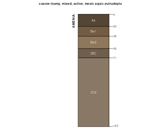
Georgia and Amenia silt loams, 2 to 8 percent slopes48B467633957649lnxct60120031:12000
Georgia and Amenia silt loams, 8 to 15 percent slopes, very stony49C123933957679lp0ct60120031:12000
Georgia and Amenia silt loams, 8 to 15 percent slopes48C114033957659lnyct60120031:12000
Georgia and Amenia silt loams, 3 to 8 percent slopes, very stony49B65033957669lnzct60120031:12000
Amenia silt loam, 3 to 8 percent slopes500B1278127656298scma00319841:25000
Amenia silt loam, 8 to 15 percent slopes500C566127656398sdma00319841:25000
Amenia silt loam, 3 to 8 percent slopes, very stony501B386827656598sgma00319841:25000
Amenia silt loam, 8 to 15 percent slopes, very stony501C355227656698shma00319841:25000
Amenia silt loam, 3 to 8 percent slopes, extremely stony502B143127656898skma00319841:25000
Amenia silt loam, 0 to 3 percent slopes500A88427656198sbma00319841:25000
Amenia silt loam, 8 to 15 percent slopes, extremely stony502C87327656998slma00319841:25000
Amenia silt loam, 15 to 25 percent slopes, very stony501D48127656798sjma00319841:25000
Amenia silt loam, 15 to 25 percent slopes500D45727656498sfma00319841:25000
Amenia silt loam, 15 to 25 percent slopes, extremely stony502D43427657098smma00319841:25000
Amenia fine sandy loam, 3 to 8 percent slopesAtB7772901039qw5ny01919951:24000
Amenia fine sandy loam, 0 to 3 percent slopesAtA5912901029qw4ny01919951:24000
Amenia fine sandy loam, 2 to 8 percent slopesAmB26292913029s3vny03120071:24000
Amenia fine sandy loam, 8 to 15 percent slopesAmC8132913019s3tny03120071:24000
Amenia loam, 3 to 8 percent slopesAmB22112917639slqny04519811:15840
Amenia loam, 0 to 3 percent slopesAmA15062917629slpny04519811:15840
Amenia loam, 3 to 8 percent slopesAgB38452677624bmhhny04920181:24000
Amenia loam, 0 to 3 percent slopesAgA12122677623bmhgny04920181:24000
Amenia loam, 3 to 8 percent slopesAmB4842927809tnjny05719731:24000
Amenia loam, 0 to 3 percent slopesAmA702927799tnhny05719731:24000
Amenia silt loam, 3 to 8 percent slopes582B44632934619vchny06519931:24000
Amenia silt loam, 0 to 3 percent slopes582A7272934609vcgny06519931:24000
Pittsfield-Amenia association, very stony, gently sloping through moderately steepPVC3452959979y09ny11519721:20000
Amenia silt loam, 3 to 8 percent slopesAmB3232959419xyhny11519721:20000
Amenia extremely stony loam, 0 to 15 percent slopesAsC34482812289fmwvt00119671:15840
Amenia stony loam, 0 to 8 percent slopesAmB25642812269fmtvt00119671:15840
Amenia extremely stony loam, 15 to 25 percent slopesAsD6252812299fmxvt00119671:15840
Amenia stony loam, 8 to 15 percent slopesAmC5492812279fmvvt00119671:15840
Amenia silt loam, 3 to 8 percent slopes86B12072815969g0rvt00319921:20000
Amenia silt loam, 3 to 8 percent slopes, very stony87B7902816009g0wvt00319921:20000
Amenia silt loam, 8 to 15 percent slopes86C7092815979g0svt00319921:20000
Amenia silt loam, 8 to 15 percent slopes, very stony87C6732816019g0xvt00319921:20000
Amenia silt loam, 0 to 3 percent slopes86A2542815959g0qvt00319921:20000
Amenia silt loam, 3 to 8 percent slopesAaB36482792189ck1vt01319561:20000
Amenia silt loam, 0 to 3 percent slopesAaA21472792179ck0vt01319561:20000
Amenia very stony silt loam, 3 to 8 percent slopesAbB7252792219ck4vt01319561:20000
Amenia very stony silt loam, 0 to 3 percent slopesAbA1922792209ck3vt01319561:20000
Amenia silt loam, 8 to 15 percent slopesAaC1302792199ck2vt01319561:20000
Amenia very stony silt loam, 8 to 15 percent slopesAbC292792229ck5vt01319561:20000
Georgia and Amenia soils, 3 to 8 percent slopes66B46932824119gw1vt02119851:20000
Georgia and Amenia soils, 8 to 15 percent slopes, very stony67C38292824169gw6vt02119851:20000
Georgia and Amenia soils, 3 to 8 percent slopes, very stony67B34522824159gw5vt02119851:20000
Georgia and Amenia soils, 8 to 15 percent slopes66C24132824129gw2vt02119851:20000
Georgia and Amenia soils, 15 to 25 percent slopes, very stony67D11602824179gw7vt02119851:20000

Map of Series Extent

Approximate geographic distribution of the AMENIA soil series. To learn more about how this distribution was mapped, or to compare this soil series extent to others, use the Series Extent Explorer (SEE) application. Source: generalization of SSURGO geometry .