Official Series Description


Lab Data Summary

Aggregate lab data for the AMBRAW soil series. This aggregation is based on all pedons with a current taxon name of AMBRAW, and applied along 1-cm thick depth slices. Solid lines are the slice-wise median, bounded on either side by the interval defined by the slice-wise 5th and 95th percentiles. The median is the value that splits the data in half. Five percent of the data are less than the 5th percentile, and five percent of the data are greater than the 95th percentile. Values along the right hand side y-axis describe the proportion of pedon data that contribute to aggregate values at this depth. For example, a value of "90%" at 25cm means that 90% of the pedons correlated to AMBRAW were used in the calculation. Source: KSSL snapshot . Methods used to assemble the KSSL snapshot used by SoilWeb / SDE

Click the image to view it full size.

Pedons used in the lab summary:

MLRALab IDPedon IDTaxonnameCINSSL / NASIS ReportsLink To SoilWeb GMap
115AGN79291979IN055029Ambraw3Primary | Supplementary | Taxonomy | Pedon | Water Retention | Correlation | Andic Soil Properties38.93415,-87.109025
115A40A0161S1963IL023001Ambraw7Primary | Supplementary | Taxonomy | Pedon | Water Retention | Correlation | Andic Soil Properties39.2230568,-87.6275024
n/aX23-961-1S1976IA045007Ambraw3Primary | Supplementary | Taxonomy | Pedon | Water Retention | Correlation | Andic Soil Propertiesn/a

Water Balance

Monthly water balance estimated using a leaky-bucket style model for the AMBRAW soil series. Monthly precipitation (PPT) and potential evapotranspiration (PET) have been estimated from the 50th percentile of gridded values (PRISM 1981-2010) overlapping with the extent of SSURGO map units containing each series as a major component. Monthly PET values were estimated using the method of Thornthwaite (1948). These (and other) climatic parameters are calculated with each SSURGO refresh and provided by the fetchOSD function of the soilDB package. Representative water storage values (“AWC” in the figures) were derived from SSURGO by taking the 50th percentile of profile-total water storage (sum[awc_r * horizon thickness]) for each soil series. Note that this representation of “water storage” is based on the average ability of most plants to extract soil water between 15 bar (“permanent wilting point”) and 1/3 bar (“field capacity”) matric potential. Soil moisture state can be roughly interpreted as “dry” when storage is depleted, “moist” when storage is between 0mm and AWC, and “wet” when there is a surplus. Clearly there are a lot of assumptions baked into this kind of monthly water balance. This is still a work in progress.

Click the image to view it full size.


Click the image to view it full size.

Sibling Summary

Siblings are those soil series that occur together in map units, in this case with the AMBRAW series. Sketches are arranged according to their subgroup-level taxonomic structure. Source: SSURGO snapshot , parsed OSD records and snapshot of SC database .

Click the image to view it full size.

Select annual climate data summaries for the AMBRAW series and siblings. Series are sorted according to hierarchical clustering of median values. Source: SSURGO map unit geometry and 1981-2010, 800m PRISM data .

Click the image to view it full size.

Geomorphic description summaries for the AMBRAW series and siblings. Series are sorted according to hierarchical clustering of proportions and relative hydrologic position within an idealized landform (e.g. top to bottom). Most soil series (SSURGO components) are associated with a hillslope position and one or more landform-specific positions: hills, mountain slopes, terraces, and/or flats. Proportions can be interpreted as an aggregate representation of geomorphic membership. The values printed to the left (number of component records) and right (Shannon entropy) of stacked bars can be used to judge the reliability of trends. Small Shannon entropy values suggest relatively consistent geomorphic association, while larger values suggest lack thereof. Source: SSURGO component records .

Click the image to view it full size.

Click the image to view it full size.

There are insufficient data to create the 3D mountains figure.

Click the image to view it full size.

Click the image to view it full size.

Competing Series

Soil series competing with AMBRAW share the same family level classification in Soil Taxonomy. Source: parsed OSD records and snapshot of the SC database .

Click the image to view it full size.

Select annual climate data summaries for the AMBRAW series and competing. Series are sorted according to hierarchical clustering of median values. Source: SSURGO map unit geometry and 1981-2010, 800m PRISM data .

Click the image to view it full size.

Geomorphic description summaries for the AMBRAW series and competing. Series are sorted according to hierarchical clustering of proportions and relative hydrologic position within an idealized landform (e.g. top to bottom). Proportions can be interpreted as an aggregate representation of geomorphic membership. Most soil series (SSURGO components) are associated with a hillslope position and one or more landform-specific positions: hills, mountain slopes, terraces, and/or flats. The values printed to the left (number of component records) and right (Shannon entropy) of stacked bars can be used to judge the reliability of trends. Shannon entropy values close to 0 represent soil series with relatively consistent geomorphic association, while values close to 1 suggest lack thereof. Source: SSURGO component records .

Click the image to view it full size.

Click the image to view it full size.

There are insufficient data to create the 3D mountains figure.

Click the image to view it full size.

Click the image to view it full size.

Soil series sharing subgroup-level classification with AMBRAW, arranged according to family differentiae. Hovering over a series name will print full classification and a small sketch from the OSD. Source: snapshot of SC database .

Block Diagrams

Click a link below to display the diagram. Note that these diagrams may be from multiple survey areas.

  1. IA-2011-06-01-11 | Louisa County - 1980

    Pattern of soils and parent material in the Titus-Ambraw-Colo association (Soil Survey of Louisa County, Iowa; 1980).

  2. IA-2011-06-01-25 | Muscatine County - 1989

    Typical pattern of soils and parent material in the Fruitfield-Elrick-Toolesboro association (Soil Survey of Muscatine County, Iowa; 1989).

  3. IA-2011-06-01-26 | Muscatine County - 1989

    Typical pattern of soils and parent material in the Ambraw-Aquolls-Colo association (Soil Survey of Muscatine County, Iowa; 1989).

Map Units

Map units containing AMBRAW as a major component. Limited to 250 records.

Map Unit Name Symbol Map Unit Area (ac) Map Unit Key National Map Unit Symbol Soil Survey Area Publication Date Map Scale
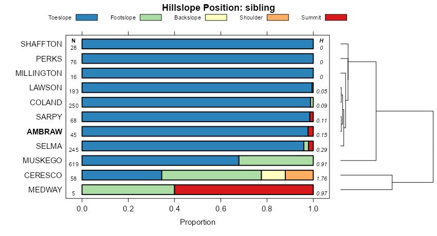
Fluvents-Ambraw complex, 0 to 2 percent slopes31514401404402fkt7ia04519781:15840
Ambraw silty clay loam, 0 to 2 percent slopes9615446404478fkwpia04519781:15840
Ambraw loam, 0 to 2 percent slopes961380405295flr1ia05719801:15840
Ambraw loam, 0 to 2 percent slopes9614971408839fqfcia11519841:15840
Ambraw loam, rarely flooded, 0 to 2 percent slopes39613039408772fqc6ia11519841:15840
Ambraw silty clay loam, 0 to 2 percent slopes9615513410052frphia13919861:15840
Ambraw loam, rarely flooded, 0 to 2 percent slopes39613769409974frlzia13919861:15840
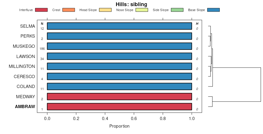
Ambraw-Perks-Lawson complex, frequently flooded, 0 to 2 percent slopes15396335410882fsk8ia16319891:15840
Ambraw clay loam, 0 to 2 percent slopes9612629411097fss6ia16319891:15840
Ambraw loam, 0 to 2 percent slopes, occasionally flooded8302A9889186280020jdbil01120071:12000
Ambraw clay loam, 0 to 2 percent slopes, rarely flooded7302A333514451961khv7il01720031:12000
Ambraw clay loam, 0 to 2 percent slopes, occasionally flooded8302A31052628408thqil01720031:12000
Ambraw clay loam, 0 to 2 percent slopes, frequently flooded, long duration3302L183014453391khzvil01720031:12000
Ambraw clay loam, 0 to 2 percent slopes, frequently flooded3302A84114449171khk7il01720031:12000
Ambraw silty clay loam, 0 to 2 percent slopes, frequently flooded3302A279124299484vjil01919991:12000
Ambraw clay loam, 0 to 2 percent slopes, frequently flooded3302A158115995651qpgwil02320061:12000
Ambraw clay loam, 0 to 2 percent slopes, occasionally flooded8302A559615703nnpdil05719971:12000
Ambraw clay loam, 0 to 2 percent slopes, occasionally flooded8302A192021175373bril06119681:15840
Ambraw loam, 0 to 2 percent slopes, frequently flooded3302A3226040992rh47il06719931:15840
Ambraw clay loam, 0 to 2 percent slopes, rarely flooded7302A15751018057135ckil07120051:12000
Ambraw loam, 0 to 2 percent slopes, frequently flooded3302A300632714p7d4il07120051:12000
Ambraw loam, 0 to 2 percent slopes, occasionally flooded8302A628324486486svil07320011:12000
Ambraw clay loam, 0 to 2 percent slopes, rarely flooded7302A114424485586skil07320011:12000
Ambraw silty clay loam, 0 to 2 percent slopes, frequently flooded3302A108724485186sfil07320011:12000
Ambraw sandy loam, 0 to 2 percent slopes, frequently flooded3302A26982631608tv1il09120031:12000
Ambraw loam, 0 to 2 percent slopes, occasionally flooded8302A2369991322128k4il09120031:12000
Ambraw clay loam, occasionally flooded83025331767675xy5il10119521:42240
Ambraw loam, 0 to 2 percent slopes, occasionally flooded8302A15379923943100fmil10320041:12000
Ambraw silty clay loam, 0 to 2 percent slopes, frequently flooded3302A514123931jdq2il10320041:12000
Ambraw silty clay loam, 0 to 2 percent slopes, occasionally flooded8302A6031988866nypil11920011:12000
Ambraw clay loam, 0 to 2 percent slopes, occasionally flooded8302A18881778225z16il12519891:15840
Ambraw clay loam, 0 to 2 percent slopes, frequently flooded3302A8401777885z03il12519891:15840
Ambraw clay loam, 0 to 2 percent slopes, rarely flooded7302A229624502886z4il13120001:12000
Ambraw silty clay loam, 0 to 2 percent slopes, occasionally flooded8302A887418413565lvil13319981:12000
Ambraw clay loam, 0 to 2 percent slopes, occasionally flooded8302A96225422002qxq1il13719841:15840
Ambraw clay loam, 0 to 2 percent slopes, rarely flooded7302A42016721461t406il13719841:15840
Ambraw clay loam, 0 to 2 percent slopes, occasionally flooded8302A89242019676s52il14920011:12000
Ambraw-Ceresco-Sarpy complex, 0 to 2 percent slopes, occasionally flooded8789A27112019786s5fil14920011:12000
Ambraw clay loam, 0 to 2 percent slopes, frequently flooded, long duration3302L10522013266rhdil14920011:12000
Ambraw silty clay loam, undrained, 0 to 2 percent slopes, occasionally flooded1302A1701728665swbil15519871:15840
Ambraw clay loam, 0 to 2 percent slopes, occasionally flooded8302A3826508432r21zil15519871:15840
Ambraw loam, 0 to 2 percent slopes, occasionally flooded8302A1631986836nr4il16120021:12000
Ambraw clay loam, 0 to 2 percent slopes, occasionally flooded8302A325325421122qvgril17119841:12000
Ambraw loam, 0 to 2 percent slopes, rarely flooded7302A585717942560pxil17919911:15840
Ambraw loam, 0 to 2 percent slopes, frequently flooded3302A262216131911r4nfil18320061:12000
Ambraw clay loam, 0 to 2 percent slopes, frequently flooded3302A97115439391ntlhil19320061:12000
Ambraw loam, 0 to 2 percent slopes, occasionally flooded8302A8678793143vmb8il19520031:12000
Ambraw clay loam, 0 to 2 percent slopes, rarely flooded7302A7527793131vm9wil19520031:12000
Ambraw silty clay loam, 0 to 2 percent slopes, frequently flooded3302A1169793114vm9bil19520031:12000
Ambraw sandy clay loam, rarely floodedAo4561615165f26in05519841:15840

Map of Series Extent

Approximate geographic distribution of the AMBRAW soil series. To learn more about how this distribution was mapped, or to compare this soil series extent to others, use the Series Extent Explorer (SEE) application. Source: generalization of SSURGO geometry .