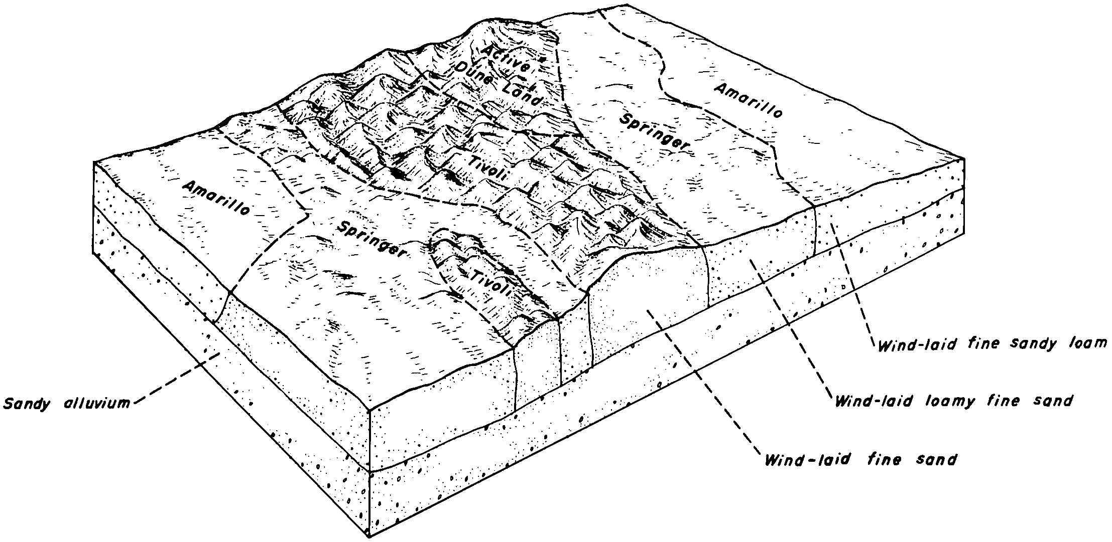
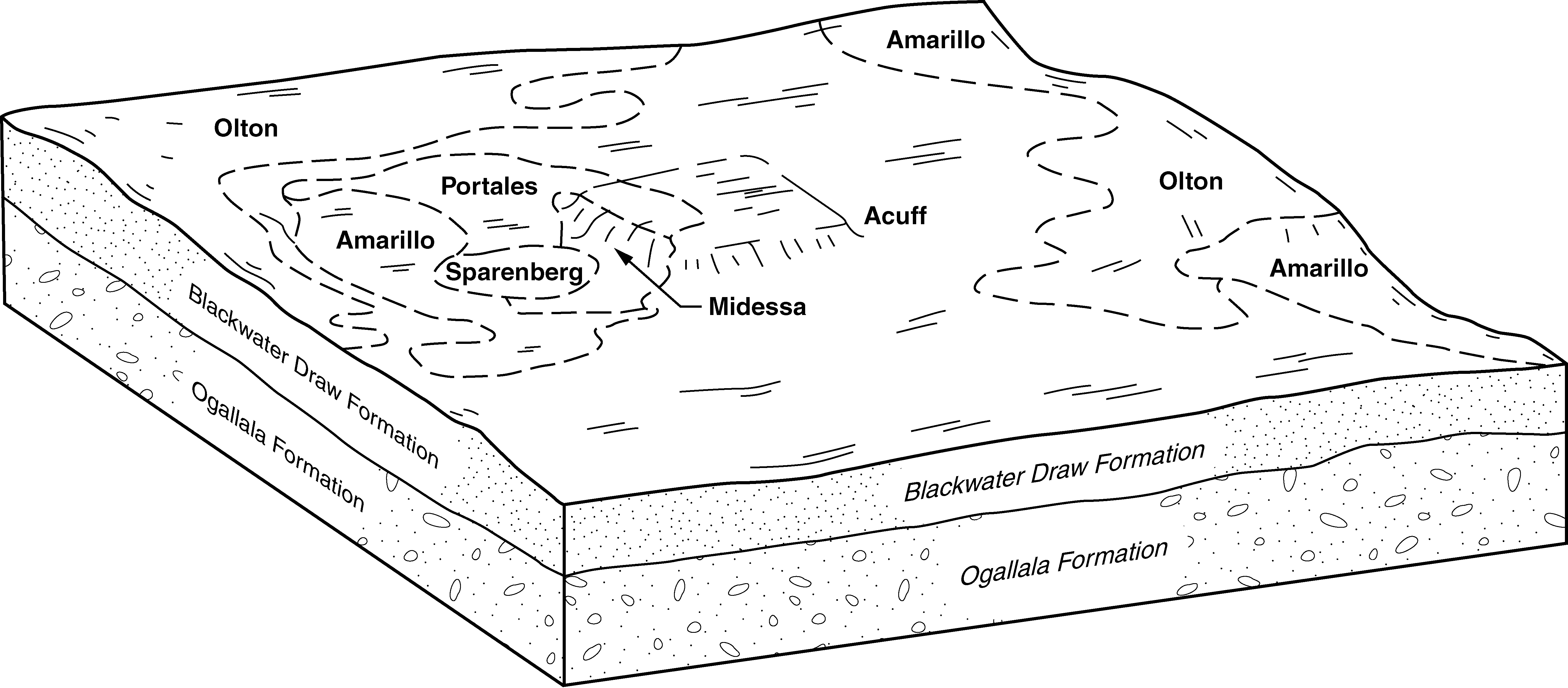
| Springer-Amarillo association | SR | 94679 | 376379 | dmn8 | nm021 | 1968 | 1:31680 |
Amarillo fine sandy loam | AM | 38744 | 376313 | dml4 | nm021 | 1968 | 1:31680 |
Springer-Amarillo association, severely eroded | SS | 3352 | 376380 | dmn9 | nm021 | 1968 | 1:31680 |
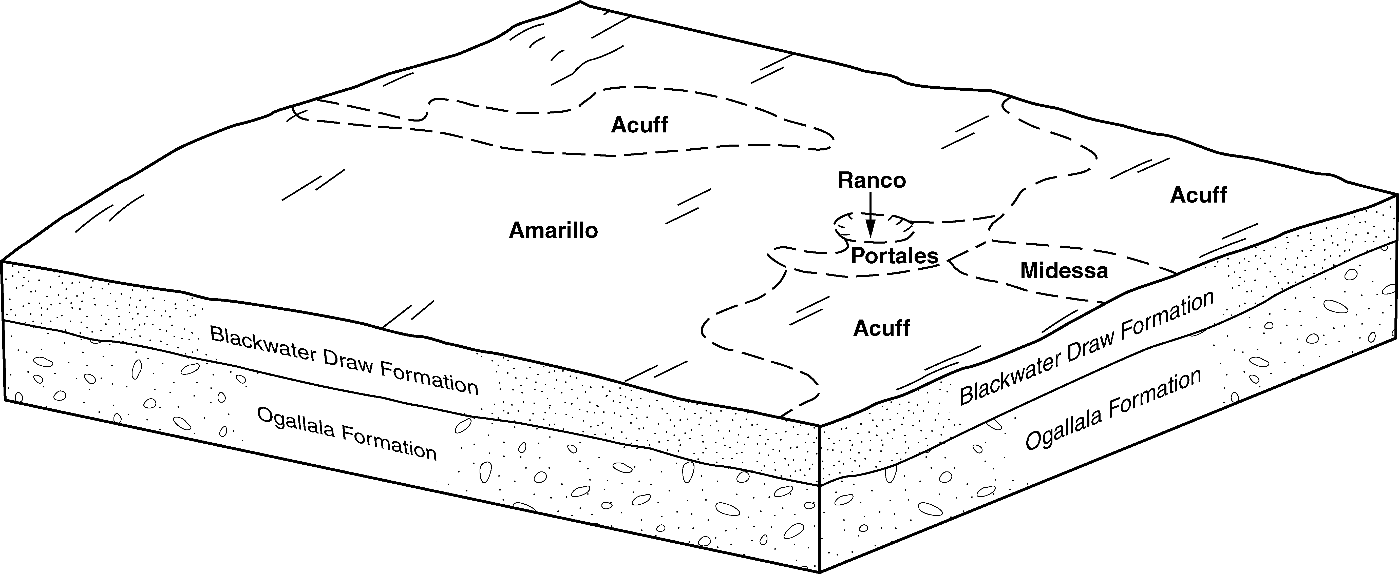
Amarillo loamy fine sand, 0 to 3 percent slopes | Ad | 29523 | 376401 | 1t1zh | nm025 | 1967 | 1:20000 |
Amarillo-Arvana loamy fine sands association, 0 to 3 percent slopes | AB | 27789 | 376394 | dmnr | nm025 | 1967 | 1:20000 |
Amarillo fine sandy loam, 0 to 1 percent slopes | Af | 16404 | 376403 | f5r6 | nm025 | 1967 | 1:20000 |
Amarillo-Arvana fine sandy loams, association, 0 to 3 percent slopes | AL | 11946 | 376395 | dmns | nm025 | 1967 | 1:20000 |
Amarillo and Gomez fine sands, 0 to 3 percent slopes | Ak | 4947 | 376406 | 2tw3z | nm025 | 1967 | 1:20000 |
Amarillo and Gomez fine sands, dry, 0 to 3 percent slopes | AU | 4192 | 376397 | 2tmph | nm025 | 1967 | 1:20000 |
Amarillo fine sandy loam, 1 to 3 percent slopes | Ag | 2908 | 376404 | f5r7 | nm025 | 1967 | 1:20000 |
Amarillo fine sandy loam, 0 to 1 percent slopes | AfA | 96907 | 1547757 | f5r6 | nm041 | 2014 | 1:24000 |
Amarillo loamy fine sand, 0 to 3 percent slopes | AmB | 82774 | 1611918 | 1t1zh | nm041 | 2014 | 1:24000 |
Amarillo fine sandy loam, 1 to 3 percent slopes | AfB | 20402 | 1547759 | f5r7 | nm041 | 2014 | 1:24000 |
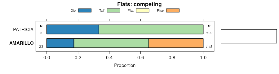
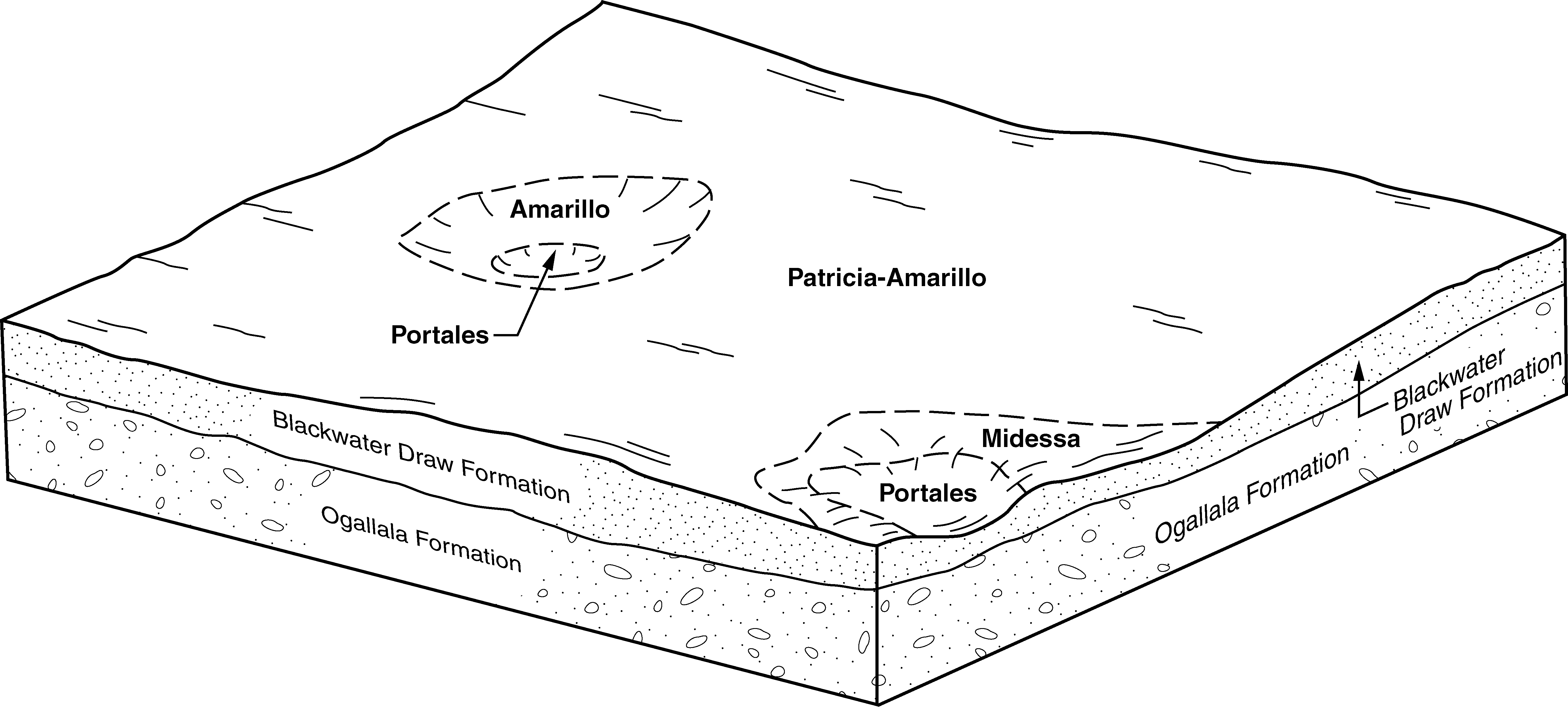
Patricia and Amarillo loamy fine sands, 0 to 3 percent slopes | PAB | 18301 | 2109255 | f5sx | nm041 | 2014 | 1:24000 |
Amarillo soils, 0 to 3 percent slopes, severely eroded | ALB | 12251 | 1610316 | 1idy9 | nm041 | 2014 | 1:24000 |
Amarillo fine sandy loam, 0 to 1 percent slopes | AfA | 161742 | 377639 | f5r6 | nm669 | 2005 | 1:24000 |
Amarillo loamy fine sand, 0 to 3 percent slopes | AnB | 55994 | 377641 | 1t1zh | nm669 | 2005 | 1:24000 |
Amarillo fine sandy loam, 1 to 3 percent slopes | AfB | 12605 | 377640 | f5r7 | nm669 | 2005 | 1:24000 |
Amarillo loamy fine sand, 0 to 3 percent slopes | AL | 31565 | 376094 | dmc2 | nm676 | 1969 | 1:31680 |
Amarillo fine sandy loam, 0 to 3 percent slopes | AR | 30403 | 376096 | dmc4 | nm676 | 1969 | 1:31680 |
Springer-Amarillo association | SF | 7003 | 376190 | dmg5 | nm676 | 1969 | 1:31680 |
Amarillo loamy fine sand, eroded | AM | 5677 | 376095 | dmc3 | nm676 | 1969 | 1:31680 |
Amarillo fine sandy loam, 1 to 3 percent slopes | MsB | 4948 | 362482 | d55z | tx011 | 1963 | 1:20000 |
Amarillo fine sandy loam, 0 to 1 percent slopes | MsA | 1644 | 362481 | d55y | tx011 | 1963 | 1:20000 |
Amarillo fine sandy loam, 3 to 5 percent slopes | MsC | 504 | 362483 | d560 | tx011 | 1963 | 1:20000 |
Amarillo fine sandy loam, 0 to 1 percent slopes | AfA | 63005 | 362561 | f5r6 | tx017 | 1960 | 1:20000 |
Amarillo loamy fine sand, 0 to 3 percent slopes | AmB | 48348 | 362566 | 1t1zh | tx017 | 1960 | 1:20000 |
Amarillo fine sandy loam, 1 to 3 percent slopes | AfB | 32663 | 362562 | f5r7 | tx017 | 1960 | 1:20000 |
Amarillo fine sandy loam, 3 to 5 percent slopes | AfC | 1709 | 362563 | f5tt | tx017 | 1960 | 1:20000 |
Amarillo fine sandy loam, 1 to 3 percent slopes | AfB | 845 | 362938 | f5r7 | tx033 | 1970 | 1:24000 |
Amarillo fine sandy loam, 0 to 1 percent slopes | AfA | 199 | 362937 | f5r6 | tx033 | 1970 | 1:24000 |
Patricia and Amarillo loamy fine sands, 0 to 3 percent slopes | PAB | 146456 | 2931530 | f5sx | tx079 | 1962 | 1:20000 |
Amarillo fine sandy loam, 0 to 1 percent slopes | AfA | 116970 | 363920 | f5r6 | tx079 | 1962 | 1:20000 |
Amarillo fine sandy loam, 1 to 3 percent slopes | AfB | 47599 | 2599094 | f5r7 | tx079 | 1962 | 1:20000 |
Amarillo fine sandy loam, 3 to 5 percent slopes | AfC | 992 | 363922 | f5tt | tx079 | 1962 | 1:20000 |
Amarillo fine sandy loam, 0 to 1 percent slopes | AfA | 27312 | 364696 | f5r6 | tx107 | 1964 | 1:20000 |
Amarillo loamy fine sand, 0 to 3 percent slopes | AmB | 7354 | 364698 | 1t1zh | tx107 | 1964 | 1:20000 |
Amarillo fine sandy loam, 1 to 3 percent slopes | AfB | 4593 | 364697 | f5r7 | tx107 | 1964 | 1:20000 |
Amarillo fine sandy loam, 1 to 3 percent slopes | AfB | 147135 | 377851 | f5r7 | tx115 | 2004 | 1:24000 |
Patricia and Amarillo loamy fine sands, 0 to 3 percent slopes | PAB | 114641 | 393625 | f5sx | tx115 | 2004 | 1:24000 |
Amarillo fine sandy loam, 0 to 1 percent slopes | AfA | 98949 | 377850 | f5r6 | tx115 | 2004 | 1:24000 |
Amarillo fine sandy loam, 1 to 3 percent slopes | AfB | 247 | 607449 | f5r7 | tx153 | 2004 | 1:24000 |
Amarillo loamy fine sand, 0 to 3 percent slopes | AmB | 48286 | 366028 | 1t1zh | tx165 | 1964 | 1:20000 |
Amarillo fine sandy loam, 0 to 1 percent slopes | AfA | 23193 | 366026 | f5r6 | tx165 | 1964 | 1:20000 |
Amarillo fine sandy loam, 1 to 3 percent slopes | AfB | 6108 | 366027 | f5r7 | tx165 | 1964 | 1:20000 |
Amarillo fine sandy loam, 1 to 3 percent slopes | AmB | 811 | 378321 | f5r7 | tx169 | 1965 | 1:24000 |
Amarillo fine sandy loam, 0 to 1 percent slopes | AmA | 568 | 378320 | f5r6 | tx169 | 1965 | 1:24000 |
Amarillo fine sandy loam, 1 to 3 percent slopes | AmB | 21383 | 366228 | f5r7 | tx173 | 1974 | 1:31680 |
Amarillo fine sandy loam, 0 to 1 percent slopes | AmA | 12198 | 366227 | f5r6 | tx173 | 1974 | 1:31680 |
Amarillo fine sandy loam, 1 to 3 percent slopes | AmB | 12321 | 366891 | f5r7 | tx189 | 1969 | 1:20000 |
Amarillo fine sandy loam, 0 to 1 percent slopes | AmA | 6141 | 366890 | f5r6 | tx189 | 1969 | 1:20000 |
Amarillo fine sandy loam, 3 to 5 percent slopes | AmC | 1462 | 366892 | f5tt | tx189 | 1969 | 1:20000 |
Amarillo loamy fine sand, 0 to 3 percent slopes | AlB | 1233 | 366889 | 1t1zh | tx189 | 1969 | 1:20000 |
Amarillo fine sandy loam, 0 to 1 percent slopes | AfA | 161509 | 378965 | f5r6 | tx219 | 1999 | 1:24000 |
Amarillo fine sandy loam, 1 to 3 percent slopes | AfB | 82852 | 378966 | f5r7 | tx219 | 1999 | 1:24000 |
Patricia and Amarillo loamy fine sands, 0 to 3 percent slopes | PAB | 44897 | 379007 | f5sx | tx219 | 1999 | 1:24000 |
Amarillo fine sandy loam, 3 to 5 percent slopes | AfC | 276 | 378967 | f5tt | tx219 | 1999 | 1:24000 |
Amarillo fine sandy loam, 1 to 3 percent slopes | AfB | 32273 | 391869 | f5r7 | tx227 | 1965 | 1:24000 |
Amarillo fine sandy loam, 0 to 1 percent slopes | AfA | 29217 | 391868 | f5r6 | tx227 | 1965 | 1:24000 |
Amarillo loamy fine sand, 0 to 3 percent slopes | AmB | 26566 | 391871 | 1t1zh | tx227 | 1965 | 1:24000 |
Amarillo fine sandy loam, 3 to 5 percent slopes | AfC | 569 | 391870 | f5tt | tx227 | 1965 | 1:24000 |
Amarillo fine sandy loam, 0 to 1 percent slopes | AfA | 144500 | 394238 | f5r6 | tx279 | 1960 | 1:20000 |
Amarillo fine sandy loam, 1 to 3 percent slopes | AfB | 79873 | 394239 | f5r7 | tx279 | 1960 | 1:20000 |
Amarillo loamy fine sand, 0 to 3 percent slopes | AmB | 28266 | 394243 | 1t1zh | tx279 | 1960 | 1:20000 |
Amarillo fine sandy loam, 3 to 5 percent slopes | AfC | 3896 | 394240 | f5tt | tx279 | 1960 | 1:20000 |
Amarillo fine sandy loam, 0 to 1 percent slopes | AfA | 79386 | 369869 | f5r6 | tx303 | 1975 | 1:20000 |
Amarillo fine sandy loam, 1 to 3 percent slopes | AfB | 26264 | 369870 | f5r7 | tx303 | 1975 | 1:20000 |
Amarillo-Urban land complex, 0 to 3 percent slopes | AfU | 11659 | 369871 | ddwb | tx303 | 1975 | 1:20000 |
Amarillo loamy fine sand, 0 to 3 percent slopes | AmB | 666 | 369861 | 1t1zh | tx303 | 1975 | 1:20000 |
Amarillo fine sandy loam, 0 to 1 percent slopes | AfA | 75160 | 379021 | f5r6 | tx305 | 1999 | 1:24000 |
Amarillo fine sandy loam, 1 to 3 percent slopes | AfB | 62167 | 379022 | f5r7 | tx305 | 1999 | 1:24000 |
Patricia and Amarillo loamy fine sands, 0 to 3 percent slopes | PAB | 33019 | 379061 | f5sx | tx305 | 1999 | 1:24000 |
Amarillo fine sandy loam, 0 to 1 percent slopes | AfA | 109856 | 370323 | f5r6 | tx317 | 1968 | 1:24000 |
Amarillo fine sandy loam, 1 to 3 percent slopes | AfB | 73155 | 370324 | f5r7 | tx317 | 1968 | 1:24000 |
Amarillo loamy fine sand, 0 to 3 percent slopes | MlB | 53968 | 370342 | 1t1zh | tx317 | 1968 | 1:24000 |
Amarillo fine sandy loam, 1 to 3 percent slopes | AfB | 69888 | 370627 | f5r7 | tx329 | 1966 | 1:31680 |
Amarillo fine sandy loam, 0 to 1 percent slopes | AfA | 60001 | 370626 | f5r6 | tx329 | 1966 | 1:31680 |
Amarillo fine sandy loam, 1 to 3 percent slopes | AfB | 33952 | 3124174 | dg6j | tx359 | 1978 | 1:24000 |
Amarillo fine sandy loam, 3 to 5 percent slopes | AfC | 10678 | 3124175 | dg6k | tx359 | 1978 | 1:24000 |
Amarillo loamy fine sand, 0 to 3 percent slopes | AmB | 10377 | 3124168 | dg6b | tx359 | 1978 | 1:24000 |
Amarillo fine sandy loam, 0 to 1 percent slopes | AfA | 5899 | 3124173 | dg6h | tx359 | 1978 | 1:24000 |
Amarillo fine sandy loam, 0 to 1 percent slopes | AfA | 26189 | 2599117 | f5r6 | tx369 | 1973 | 1:24000 |
Amarillo fine sandy loam, 1 to 3 percent slopes | AfB | 8905 | 2599118 | f5r7 | tx369 | 1973 | 1:24000 |
Amarillo fine sandy loam, 3 to 5 percent slopes | AfC | 1269 | 2599144 | f5tt | tx369 | 1973 | 1:24000 |
Amarillo-Urban land complex | AfU | 1207 | 3124250 | 2mhv8 | tx375 | 1974 | 1:24000 |
Amarillo fine sandy loam, 1 to 3 percent slopes | AfB | 6247 | 371379 | f5r7 | tx381 | 1999 | 1:24000 |
Amarillo fine sandy loam, 3 to 5 percent slopes | AfC | 848 | 371380 | f5tt | tx381 | 1999 | 1:24000 |
Patricia and Amarillo loamy fine sands, 0 to 3 percent slopes | PAB | 262308 | 372567 | f5sx | tx445 | 1999 | 1:24000 |
Amarillo fine sandy loam, 0 to 1 percent slopes | AfA | 76801 | 372533 | f5r6 | tx445 | 1999 | 1:24000 |
Amarillo fine sandy loam, 1 to 3 percent slopes | AfB | 52241 | 372534 | f5r7 | tx445 | 1999 | 1:24000 |
Patricia and Amarillo loamy fine sands, 0 to 3 percent slopes | PAB | 282166 | 2931488 | f5sx | tx501 | 1962 | 1:31680 |
Amarillo fine sandy loam, 0 to 1 percent slopes | AfA | 18136 | 373710 | f5r6 | tx501 | 1962 | 1:31680 |
Amarillo fine sandy loam, 1 to 3 percent slopes | AfB | 5836 | 373711 | f5r7 | tx501 | 1962 | 1:31680 |