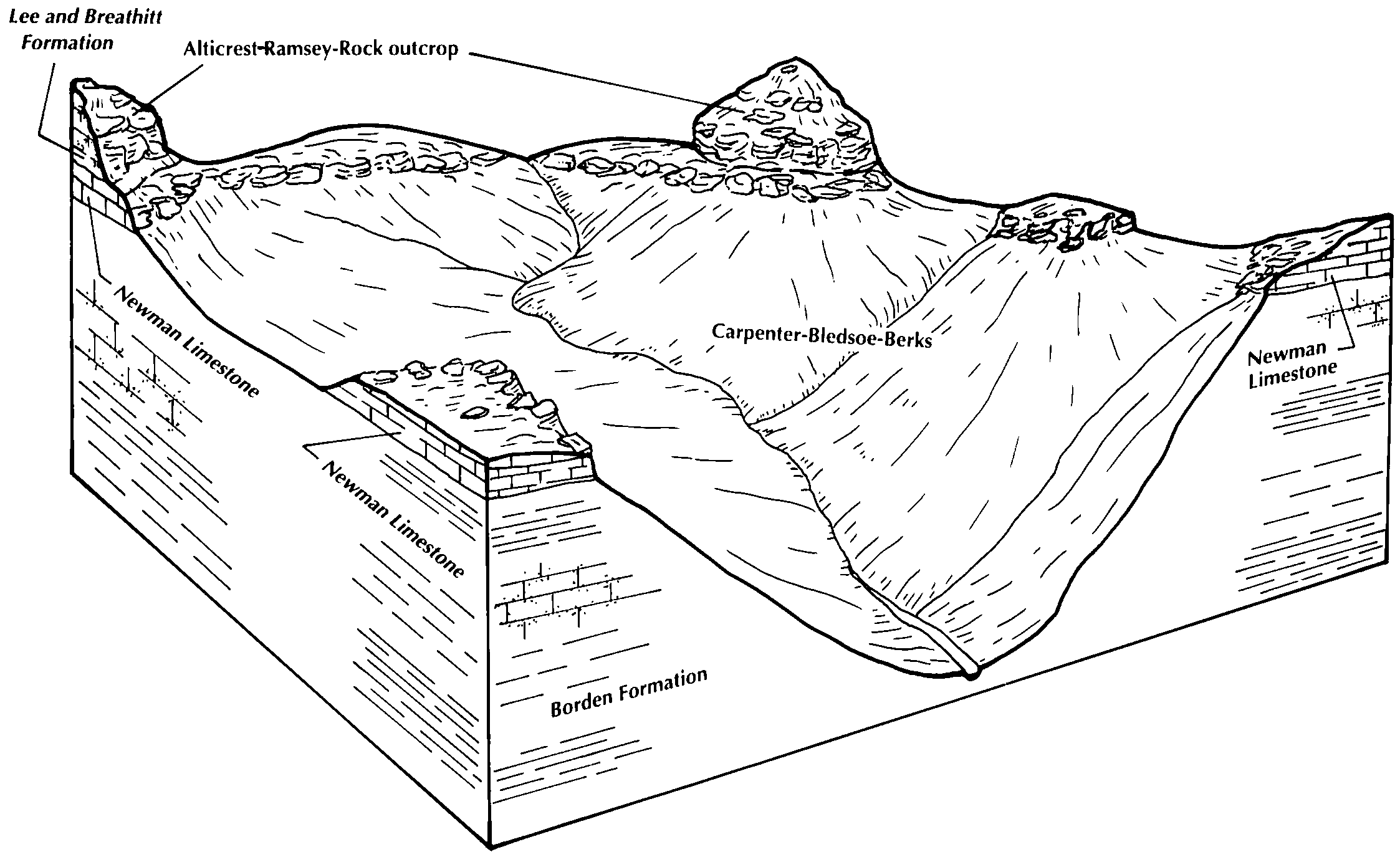
| Helechawa-Alticrest-Rock outcrop complex, 30 to 50 percent slopes | HeF | 901 | 1727531 | 1vzmt | ky011 | 2006 | 1:12000 |
Rigley-Shelocta-Alticrest complex, 20 to 80 percent slopes, stony, very rocky | uRshF | 18419 | 2997076 | 2qyt0 | ky199 | 1969 | 1:12000 |
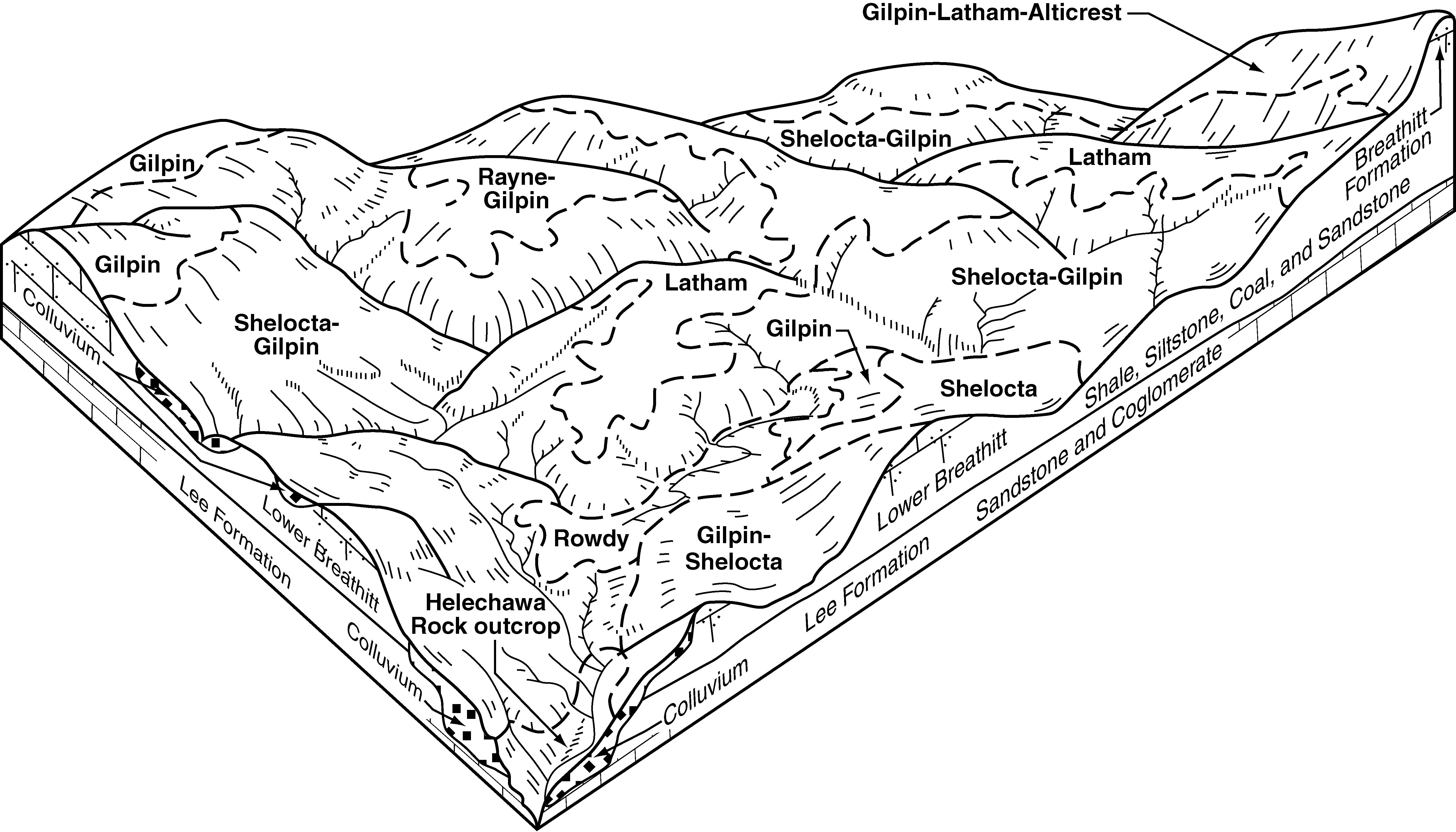
Gilpin-Latham-Alticrest complex, 15 to 35 percent slopes, rocky | GlE | 7131 | 557794 | lqfc | ky616 | 2004 | 1:24000 |
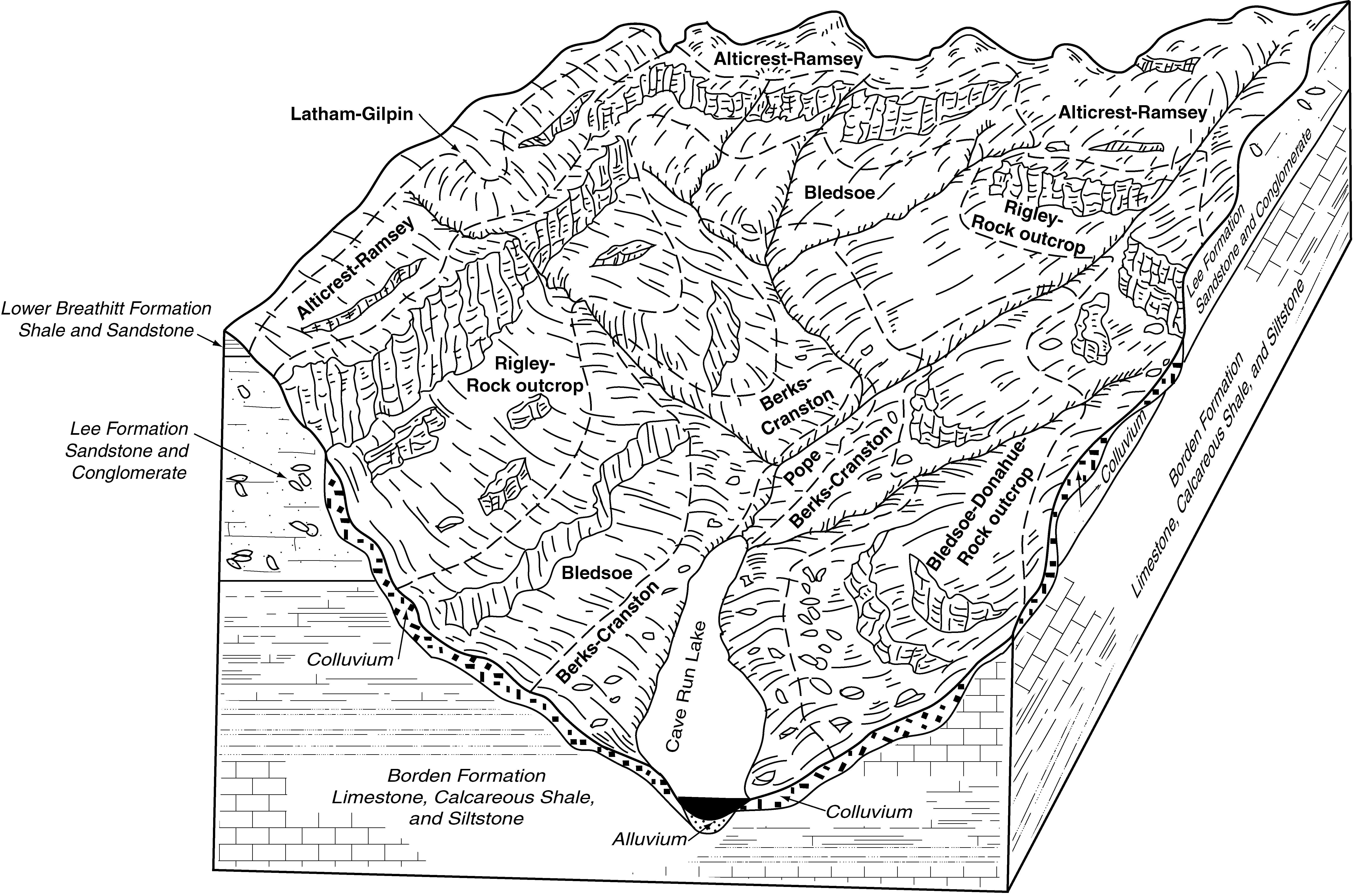
Alticrest-Ramsey-Rock outcrop complex, 20 to 65 percent slopes | ArF | 3251 | 557748 | lqcw | ky616 | 2004 | 1:24000 |
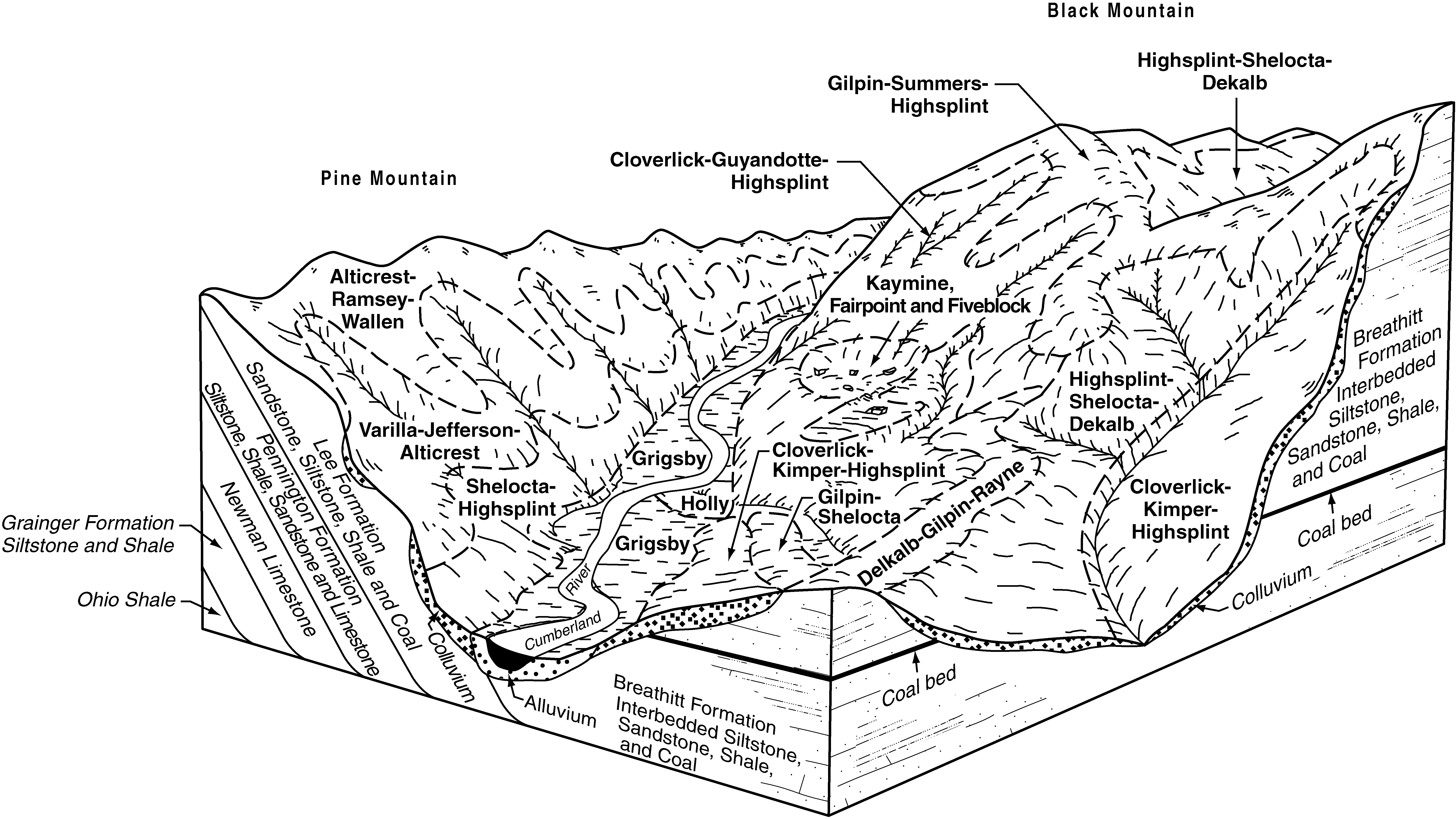
Alticrest-Ramsey-Wallen complex, 20 to 55 percent slopes, rocky | AtF | 3825 | 550721 | lh26 | ky626 | 1997 | 1:24000 |
Varilla-Jefferson-Alticrest complex, 35 to 75 percent slopes, very rocky | VaF | 3439 | 550751 | lh35 | ky626 | 1997 | 1:24000 |
Rigley-Shelocta-Alticrest complex, 20 to 80 percent slopes, stony, very rocky | uRshF | 19761 | 2997077 | 2qyt0 | ky628 | 1973 | 1:20000 |
Rigley-Shelocta-Alticrest complex, 20 to 80 percent slopes, stony, very rocky | uRshF | 24040 | 2997078 | 2qyt0 | ky630 | 1966 | 1:15840 |
Wallen-Ramsey-Alticrest complex, 15 to 60 percent slopes, very rocky | 5E | 2007 | 740290 | svbb | ky630 | 1966 | 1:15840 |
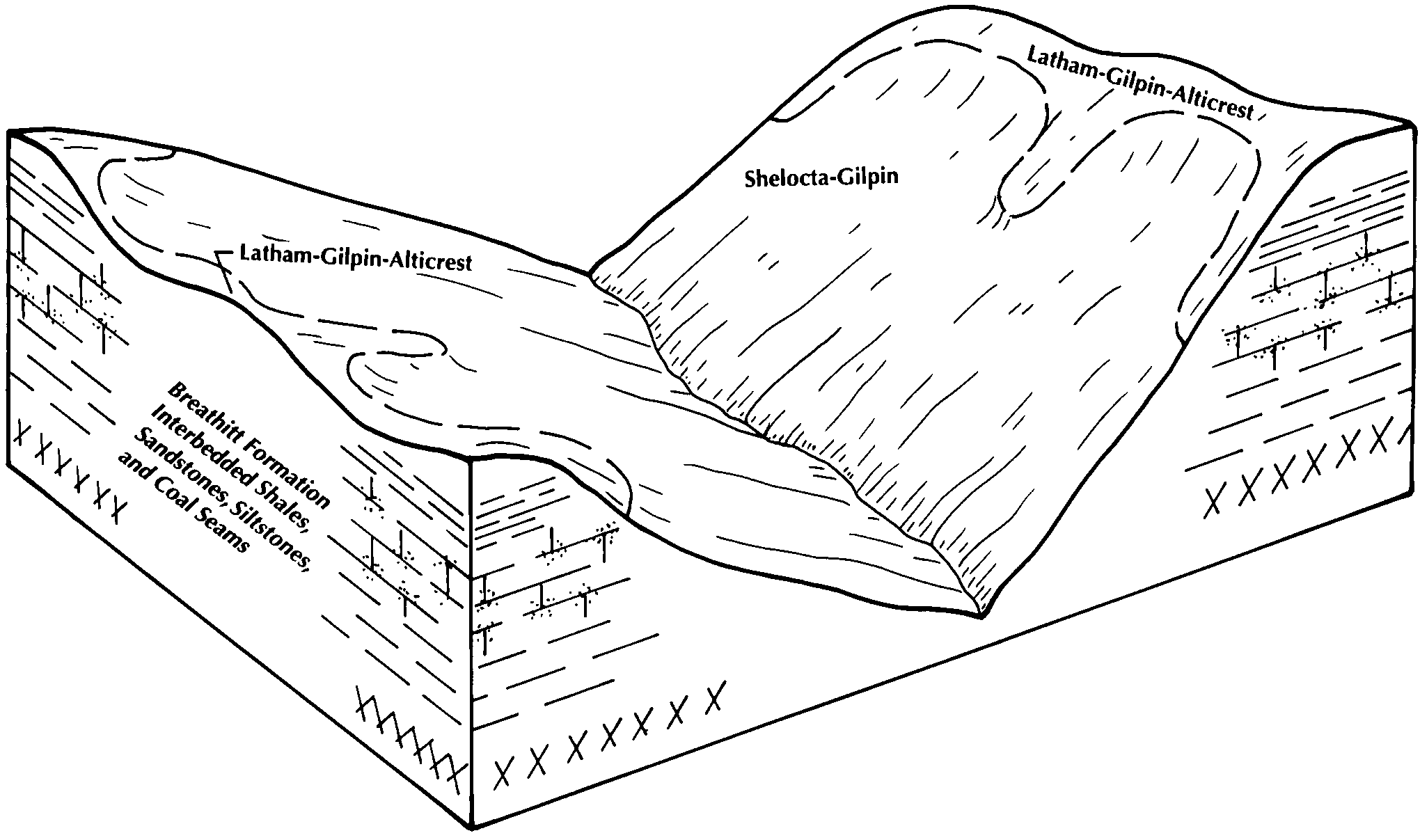
Latham-Gilpin-Alticrest complex, 20 to 65 percent slopes | LeF | 29468 | 550841 | lh62 | ky634 | 1989 | 1:20000 |
Alticrest-Ramsey-Rock outcrop complex, 20 to 65 percent slopes | ArF | 13594 | 550820 | lh5d | ky634 | 1989 | 1:20000 |
Alticrest-Totz-Helechawa complex, rocky, 20 to 55 percent slopes | AtF | 36395 | 552108 | ljhy | ky638 | 1989 | 1:24000 |
Alticrest-Ramsey complex, rocky, 20 to 60 percent slopes | ArF | 2308 | 550926 | lh8t | ky641 | 1994 | 1:24000 |
Ramsey-Alticrest-Rock outcrop complex, 5 to 20 percent slopes | RaD | 59766 | 2439178 | 2w2mk | tn701 | 1985 | 1:24000 |
Dekalb-Alticrest complex, 35 to 55 percent slopes, very stony | 16E | 10787 | 834339 | x065 | va005 | 2003 | 1:24000 |
Dekalb-Alticrest complex, 15 to 35 percent slopes, very stony | 16D | 2321 | 834338 | x064 | va005 | 2003 | 1:24000 |
Alticrest-Dekalb complex, 8 to 15 percent slopes, very stony | 3C | 303 | 834318 | x05h | va005 | 2003 | 1:24000 |
Dekalb-Alticrest complex, 35 to 55 percent slopes, very stony | 12E | 5270 | 1451468 | 1kqck | va017 | 2005 | 1:24000 |
Dekalb-Alticrest complex, 15 to 35 percent slopes, very stony | 12D | 2570 | 1451467 | 1kqcj | va017 | 2005 | 1:24000 |
Alticrest-Dekalb complex, 8 to 15 percent slopes, very stony | 3C | 517 | 1451466 | 1kqch | va017 | 2005 | 1:24000 |
Ramsey-Alticrest-Rock outcrop complex, 35 to 80 percent slopes | 21F | 6744 | 2399881 | 2lk8j | va051 | 2008 | 1:24000 |
Alticrest fine sandy loam, 15 to 35 percent slopes, rocky | 1D | 2205 | 2399851 | 2lk7k | va051 | 2008 | 1:24000 |
Alticrest fine sandy loam, 35 to 55 percent slopes, rocky | 1E | 1477 | 2399852 | 2lk7l | va051 | 2008 | 1:24000 |
Dekalb-Alticrest complex, 35 to 55 percent slopes, very stony | 11F | 702 | 2512034 | 2q7vf | va091 | 2010 | 1:24000 |
Dekalb-Alticrest complex, 15 to 35 percent slopes, very stony | 11E | 530 | 2512033 | 2q7vd | va091 | 2010 | 1:24000 |
Alticrest-Dekalb complex, 8 to 15 percent slopes, very stony | 2C | 93 | 2508630 | 2q7v0 | va091 | 2010 | 1:24000 |
Wallen-Alticrest complex, 35 to 55 percent slopes, very stony | 34E | 5199 | 521753 | khxr | va105 | 1997 | 1:24000 |
Wallen-Alticrest complex, 15 to 35 percent slopes, very stony | 34D | 1860 | 521752 | khxq | va105 | 1997 | 1:24000 |
Alticrest-Gilpin complex, 15 to 35 percent slopes | 2D | 1251 | 521763 | khy2 | va105 | 1997 | 1:24000 |
Alticrest fine sandy loam, 25 to 40 percent slopes | 2E | 8618 | 522161 | kjbx | va185 | 1996 | 1:24000 |
Alticrest fine sandy loam, 15 to 25 percent slopes | 2D | 1624 | 522160 | kjbw | va185 | 1996 | 1:24000 |
Cedarcreek-Alticrest-Rock outcrop complex, 15 to 40 percent slopes, very stony | 14E | 1508 | 522174 | kjcb | va185 | 1996 | 1:24000 |
Alticrest fine sandy loam, 7 to 15 percent slopes | 2C | 209 | 522159 | kjbv | va185 | 1996 | 1:24000 |
Cedarcreek-Alticrest-Rock outcrop complex, 5 to 15 percent slopes, very stony | 14C | 98 | 522173 | kjc9 | va185 | 1996 | 1:24000 |
Varilla-Jefferson-Alticrest complex, 35 to 75 percent slopes, very rocky | 80G | 2582 | 2508619 | 2q7s3 | va195 | 2010 | 1:24000 |
Ramsey-Alticrest-Rock outcrop complex, 35 to 80 percent slopes | 66G | 2258 | 2508604 | 2q7rk | va195 | 2010 | 1:24000 |
Wallen-Alticrest complex, 35 to 55 percent slopes, very stony | 82F | 1544 | 2508623 | 2q7tt | va195 | 2010 | 1:24000 |
Alticrest-Gilpin complex, 15 to 35 percent slopes | 4E | 982 | 2507469 | 2q2y5 | va195 | 2010 | 1:24000 |
Alticrest fine sandy loam, 35 to 55 percent slopes, rocky | 3F | 939 | 2507468 | 2q2y4 | va195 | 2010 | 1:24000 |
Alticrest fine sandy loam, 15 to 35 percent slopes, rocky | 3E | 926 | 2507467 | 2q2y3 | va195 | 2010 | 1:24000 |
Wallen-Alticrest complex, 15 to 35 percent slopes, very stony | 82E | 527 | 2508622 | 2q7s4 | va195 | 2010 | 1:24000 |
Alticrest-Ramsey-Wallen complex, 20 to 55 percent slopes, rocky | 5F | 316 | 2507470 | 2q7nz | va195 | 2010 | 1:24000 |
McClung-Alticrest complex, 35 to 55 percent slopes, very rocky | 53F | 111 | 2508583 | 2q7r1 | va195 | 2010 | 1:24000 |
McClung-Alticrest complex, 35 to 55 percent slopes, stony | 52F | 69 | 2508582 | 2q7r0 | va195 | 2010 | 1:24000 |


