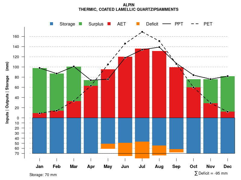
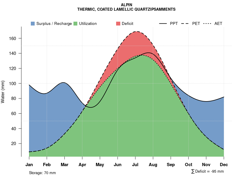
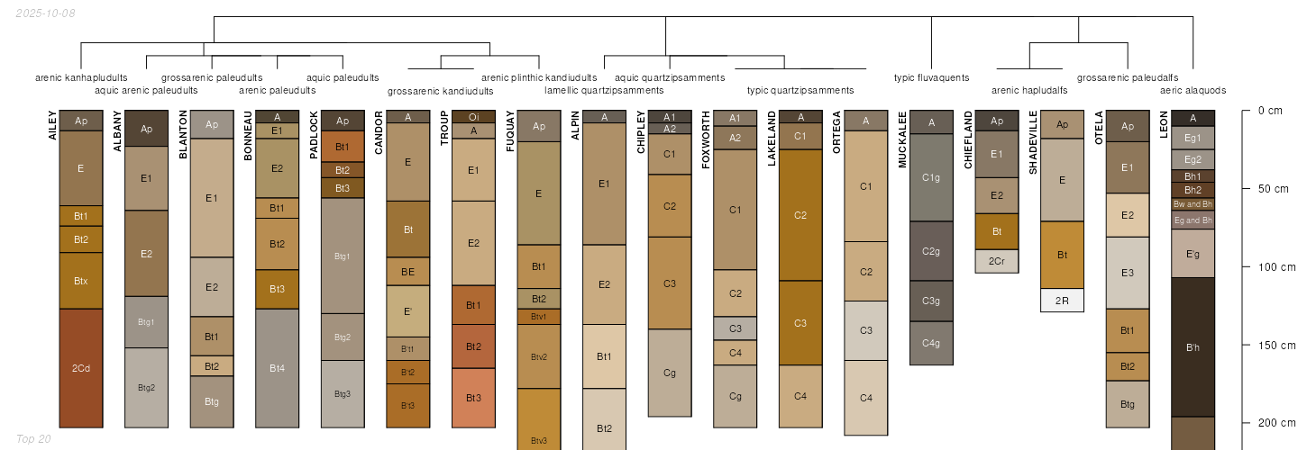
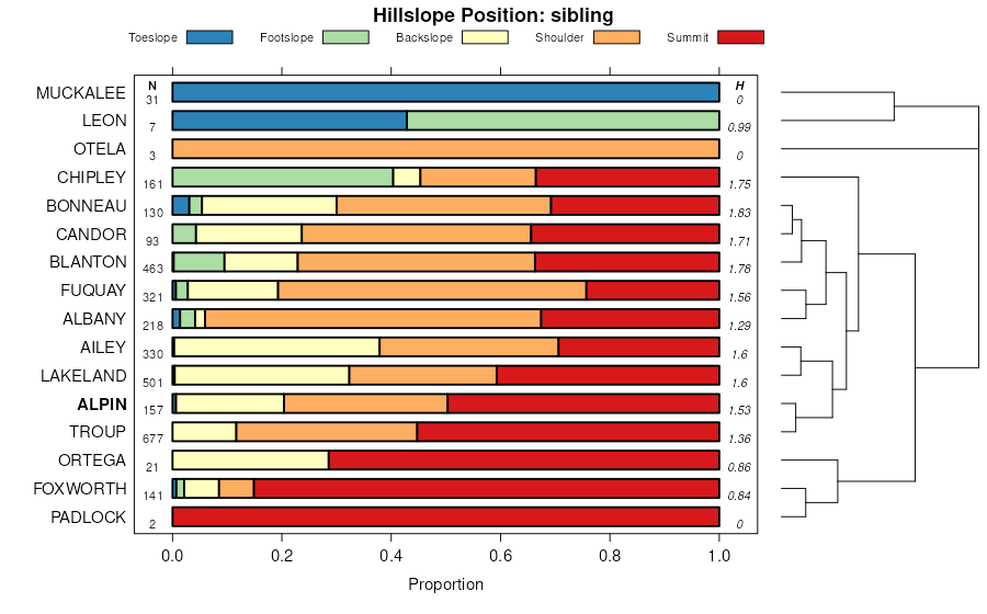
Official Series Description


Lab Data Summary

Aggregate lab data for the ALPIN soil series. This aggregation is based on all pedons with a current taxon name of ALPIN, and applied along 1-cm thick depth slices. Solid lines are the slice-wise median, bounded on either side by the interval defined by the slice-wise 5th and 95th percentiles. The median is the value that splits the data in half. Five percent of the data are less than the 5th percentile, and five percent of the data are greater than the 95th percentile. Values along the right hand side y-axis describe the proportion of pedon data that contribute to aggregate values at this depth. For example, a value of "90%" at 25cm means that 90% of the pedons correlated to ALPIN were used in the calculation. Source: KSSL snapshot . Methods used to assemble the KSSL snapshot used by SoilWeb / SDE

Click the image to view it full size.

Pedons used in the lab summary:

MLRALab IDPedon IDTaxonnameCINSSL / NASIS ReportsLink To SoilWeb GMap
133AS37_0231977-FL073-S37_023Alpin3Primary | Supplementary | Taxonomy | Pedon | Water Retention | Correlation | Andic Soil Properties30.3232536,-84.2963486
133AS33_0091981-FL065-S33_009Alpin3Primary | Supplementary | Taxonomy | Pedon | Water Retention | Correlation | Andic Soil Properties30.3970585,-84.0718918
133AS39_0021989-FL077-S39_002Alpinn/aPrimary | Supplementary | Taxonomy | Pedon | Water Retention | Correlation | Andic Soil Properties30.4594383,-84.8683319
137S87SC025-2S1985SC025001Alpin3Primary | Supplementary | Taxonomy | Pedon | Water Retention | Correlation | Andic Soil Properties34.6476741,-80.2015566
138S40_0101984-FL079-S40_010Alpin3Primary | Supplementary | Taxonomy | Pedon | Water Retention | Correlation | Andic Soil Properties30.2797661,-83.2670517
138S24_0031988-FL047-S24_003Alpin3Primary | Supplementary | Taxonomy | Pedon | Water Retention | Correlation | Andic Soil Properties30.4683583,-83.1441889
138S12_005S1978FL023005Alpin3Primary | Supplementary | Taxonomy | Pedon | Water Retention | Correlation | Andic Soil Properties29.9873314,-82.7684021
138S21_001S1986FL041001Alpin3Primary | Supplementary | Taxonomy | Pedon | Water Retention | Correlation | Andic Soil Properties29.7435055,-82.8807755
152AS65_0121986-FL129-S65_012Alpin3Primary | Supplementary | Taxonomy | Pedon | Water Retention | Correlation | Andic Soil Properties30.0759201,-84.3849869
153AS16_0201975-FL031-S16_020Alpin3Primary | Supplementary | Taxonomy | Pedon | Water Retention | Correlation | Andic Soil Properties30.3828201,-81.6986465
153AS04_0071986-FL007-S04_007Alpin3Primary | Supplementary | Taxonomy | Pedon | Water Retention | Correlation | Andic Soil Properties29.7696552,-82.0568008
153AS45_0301986-FL089-S45_030Alpin3Primary | Supplementary | Taxonomy | Pedon | Water Retention | Correlation | Andic Soil Properties30.746767,-82.0175934

Water Balance

Monthly water balance estimated using a leaky-bucket style model for the ALPIN soil series. Monthly precipitation (PPT) and potential evapotranspiration (PET) have been estimated from the 50th percentile of gridded values (PRISM 1981-2010) overlapping with the extent of SSURGO map units containing each series as a major component. Monthly PET values were estimated using the method of Thornthwaite (1948). These (and other) climatic parameters are calculated with each SSURGO refresh and provided by the fetchOSD function of the soilDB package. Representative water storage values (“AWC” in the figures) were derived from SSURGO by taking the 50th percentile of profile-total water storage (sum[awc_r * horizon thickness]) for each soil series. Note that this representation of “water storage” is based on the average ability of most plants to extract soil water between 15 bar (“permanent wilting point”) and 1/3 bar (“field capacity”) matric potential. Soil moisture state can be roughly interpreted as “dry” when storage is depleted, “moist” when storage is between 0mm and AWC, and “wet” when there is a surplus. Clearly there are a lot of assumptions baked into this kind of monthly water balance. This is still a work in progress.

Click the image to view it full size.


Click the image to view it full size.

Sibling Summary

Siblings are those soil series that occur together in map units, in this case with the ALPIN series. Sketches are arranged according to their subgroup-level taxonomic structure. Source: SSURGO snapshot , parsed OSD records and snapshot of SC database .

Click the image to view it full size.

Select annual climate data summaries for the ALPIN series and siblings. Series are sorted according to hierarchical clustering of median values. Source: SSURGO map unit geometry and 1981-2010, 800m PRISM data .

Click the image to view it full size.

Geomorphic description summaries for the ALPIN series and siblings. Series are sorted according to hierarchical clustering of proportions and relative hydrologic position within an idealized landform (e.g. top to bottom). Most soil series (SSURGO components) are associated with a hillslope position and one or more landform-specific positions: hills, mountain slopes, terraces, and/or flats. Proportions can be interpreted as an aggregate representation of geomorphic membership. The values printed to the left (number of component records) and right (Shannon entropy) of stacked bars can be used to judge the reliability of trends. Small Shannon entropy values suggest relatively consistent geomorphic association, while larger values suggest lack thereof. Source: SSURGO component records .

Click the image to view it full size.

Click the image to view it full size.

There are insufficient data to create the 3D mountains figure.

Click the image to view it full size.

Click the image to view it full size.

Competing Series

Soil series competing with ALPIN share the same family level classification in Soil Taxonomy. Source: parsed OSD records and snapshot of the SC database .

Click the image to view it full size.

Select annual climate data summaries for the ALPIN series and competing. Series are sorted according to hierarchical clustering of median values. Source: SSURGO map unit geometry and 1981-2010, 800m PRISM data .

Click the image to view it full size.

Geomorphic description summaries for the ALPIN series and competing. Series are sorted according to hierarchical clustering of proportions and relative hydrologic position within an idealized landform (e.g. top to bottom). Proportions can be interpreted as an aggregate representation of geomorphic membership. Most soil series (SSURGO components) are associated with a hillslope position and one or more landform-specific positions: hills, mountain slopes, terraces, and/or flats. The values printed to the left (number of component records) and right (Shannon entropy) of stacked bars can be used to judge the reliability of trends. Shannon entropy values close to 0 represent soil series with relatively consistent geomorphic association, while values close to 1 suggest lack thereof. Source: SSURGO component records .

Click the image to view it full size.

Click the image to view it full size.

There are insufficient data to create the 3D mountains figure.

Click the image to view it full size.

There are insufficient data to create the 3D flats position figure.

Soil series sharing subgroup-level classification with ALPIN, arranged according to family differentiae. Hovering over a series name will print full classification and a small sketch from the OSD. Source: snapshot of SC database .

Block Diagrams

No block diagrams are available.

Map Units

Map units containing ALPIN as a major component. Limited to 250 records.

Map Unit Name Symbol Map Unit Area (ac) Map Unit Key National Map Unit Symbol Soil Survey Area Publication Date Map Scale
Alpin sand, 0 to 3 percent slopesApA5920329615c1zral06119731:20000
Alpin fine sand, 0 to 5 percent slopes3171207974502v174fl02319811:24000
Alpin fine sand, 5 to 12 percent slopes4990797461vrtkfl02319811:24000
Alpin fine sand, occasionally flooded5550797472vrtxfl02319811:24000
Bonifay-Alpin complex, 0 to 5 percent slopes91115513815491hcm3fl03920061:12000
Alpin fine sand, 0 to 5 percent slopes35117903218162v174fl04119891:20000
Alpin sand, 0 to 5 percent slopes32907011488262xnrdfl04719951:24000
Alpin fine sand, 0 to 5 percent slopes, occasionally flooded223280114881817kfnfl04719951:24000
Alpin sand, 5 to 8 percent slopes41305114883717kg8fl04719951:24000
Otela-Alpin complex, 0 to 5 percent slopes491010114884617kgkfl04719951:24000
Alpin-Shadeville complex, karst60620114885917kgzfl04719951:24000
Alpin fine sand, 0 to 5 percent slopes281310700490rhxgfl06519841:20000
Alpin fine sand, 5 to 8 percent slopes43106700502rhxvfl06519841:20000
Alpin sand, 0 to 5 percent slopes31761014544381ktgcfl07319891:20000
Alpin-Foxworth complex, 5 to 12 percent slopes42800322728bttlfl07720041:24000
Alpin sand32843013802951hb9nfl07919881:15840
Alpin fine sand, occasionally flooded78396013803441hbc7fl07919881:15840
Blanton-Alpin-Bonneau complex, 0 to 5 percent slopes139003110233282w4gjfl12120031:24000
Alpin fine sand, 0 to 5 percent slopes297727710233432v174fl12120031:24000
Blanton-Foxworth-Alpin complex, 0 to 5 percent slopes4327535102335713bwjfl12120031:24000
Otela-Alpin-Chiefland complex, 0 to 5 percent slopes7116068102338513bxffl12120031:24000
Blanton-Alpin complex, 0 to 5 percent slopes, occasionally flooded1011925102332513bvhfl12120031:24000
Blanton-Padlock-Alpin complex, 0 to 5 percent slopes224119102333613bvvfl12120031:24000
Alpin fine sand, 0 to 5 percent slopes, occasionally flooded383962102335213bwcfl12120031:24000
Alpin fine sand, 5 to 12 percent slopes302167102334413bw3fl12120031:24000
Otela-Alpin fine sands, 0 to 5 percent slopes471377013990731hyvdfl12919881:24000
Alpin sand, 0 to 5 percent slopes4860013990671hyv6fl12919881:24000
Alpin fine sand, 1 to 5 percent slopesAnB24601127923scgnc07919781:24000
Alpin sand, 0 to 6 percent slopes, Southern Coastal PlainAnB14301130792wdwpnc08519841:24000
Alpin fine sand, 0 to 6 percent slopesAnB60081159593wnmnc10319791:24000
Alpin fine sand, 1 to 6 percent slopesAnB16931160663ws2nc13319841:24000
Alpin fine sand, 0 to 5 percent slopesAnB3261161113wtjnc13719841:24000
Alpin fine sand, 1 to 6 percent slopesAnB190111161533wvwnc14119861:24000
Alaga loamy sand, banded substratum, 0 to 6 percent slopes (Alpin)AgB116231143083tycnc14719691:15840
Alpin sand, 0 to 6 percent slopes, Southern Coastal PlainAnB693329506522wdwpsc01719931:24000
Alpin sand, 0 to 6 percent slopes, Carolina and Georgia SandhillsApB584829506512wdwnsc01719931:24000
Alpin sand, 6 to 10 percent slopesApC22941323112wb99sc01719931:24000
Alpin sand, 10 to 15 percent slopesApD3901323122wb98sc01719931:24000
Alpin sand, 0 to 6 percent slopes, Carolina and Georgia SandhillsApB520281319842wdwnsc02519891:20000
Alpin sand, 6 to 10 percent slopesApC272561319852wb99sc02519891:20000
Alpin sand, 10 to 15 percent slopesApD47811319862wb98sc02519891:20000
Alpin fine sand, 0 to 6 percent slopes18B66371322604fmgsc02919801:20000
Alpin sand, 0 to 6 percent slopes, Carolina and Georgia SandhillsApB456729506542wdwnsc03119981:24000
Alpin sand, 0 to 6 percent slopes, Southern Coastal PlainAnB305029506552wdwpsc03119981:24000
Alpin sand, 6 to 10 percent slopesApC11546187782wb99sc03119981:24000
Alpin sand, 10 to 15 percent slopesApD1986187772wb98sc03119981:24000
Alpin fine sand, 0 to 6 percent slopesApB12001297844c1lsc03519851:20000
Alpin sand, 0 to 6 percent slopesApB6071300824cc6sc04919901:20000
Alpin sand, 0 to 6 percent slopes, Carolina and Georgia SandhillsApB12323942772wdwnsc05719671:20000
Alpin sand, 0 to 6 percent slopes, Carolina and Georgia SandhillsApB404429506582wdwnsc06120051:24000
Alpin sand, 0 to 6 percent slopes, Southern Coastal PlainAnB100429506592wdwpsc06120051:24000
Alpin sand, 6 to 15 percent slopesApD64916064971qxphsc06120051:24000
Alpin sand, 0 to 6 percent slopes, Carolina and Georgia SandhillsApB578429506612wdwnsc06919951:24000
Alpin sand, 6 to 10 percent slopesApC9841306022wb99sc06919951:24000
Alpin sand, 0 to 6 percent slopes, Southern Coastal PlainAnB80429506602wdwpsc06919951:24000
Alpin sand, 0 to 6 percent slopes, Southern Coastal PlainApB90301308712wdwpsc07519851:20000
Alpin sand, 6 to 10 percent slopesApC5601308722wb9bsc07519851:20000
Alpin-Candor-Troup complex, 0 to 6 percent slopesApB62024858772pfrlsc08519691:20000
Ailey-Troup-Alpin complex, 10 to 15 percent slopesAaD31724858652pfr6sc08519691:20000
Alpin sand, 0 to 6 percent slopes, Carolina and Georgia SandhillsApB209671301792wdwnsc61019851:20000
Alpin sand, 6 to 10 percent slopesApC19701301802wb99sc61019851:20000
Alpin sand, 10 to 15 percent slopesApD12601301812wb98sc61019851:20000

Map of Series Extent

Approximate geographic distribution of the ALPIN soil series. To learn more about how this distribution was mapped, or to compare this soil series extent to others, use the Series Extent Explorer (SEE) application. Source: generalization of SSURGO geometry .