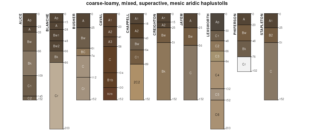
| Nelson-Alice fine sandy loams, rolling | Ne | 5546 | 346087 | cm43 | mt607 | 1970 | 1:24000 |
Alice fine sandy loam, 4 to 15 percent slopes | Ar | 1759 | 345860 | 3105q | mt607 | 1970 | 1:24000 |
Alice fine sandy loam, 0 to 4 percent slopes | Ar | 3383 | 347031 | 3105x | mt611 | 1971 | 1:24000 |
Alice fine sandy loam, 4 to 15 percent slopes | As | 1672 | 347032 | 3105q | mt611 | 1971 | 1:24000 |
Alice fine sandy loam, 3 to 6 percent slopes | 5902 | 6963 | 1692447 | 1tt42 | ne007 | 1988 | 1:20000 |
Alice fine sandy loam, 0 to 3 percent slopes | 5901 | 5854 | 1692446 | 1tt41 | ne007 | 1988 | 1:20000 |
Alice fine sandy loam, 6 to 9 percent slopes, eroded | 5903 | 2652 | 1692448 | 1tt43 | ne007 | 1988 | 1:20000 |
Chappell-Alice-Broadwater complex, 0 to 3 percent slopes | 1371 | 63 | 2229362 | 2dttx | ne033 | 1989 | 1:20000 |
Chappell-Alice-Broadwater complex, 0 to 3 percent slopes | 1371 | 14357 | 1698800 | 1v0r0 | ne049 | 2000 | 1:24000 |
Chappell-Alice-Broadwater complex, 0 to 3 percent slopes | 1371 | 1579 | 2219577 | 2dhn8 | ne101 | 1990 | 1:20000 |
Alice fine sandy loam, 0 to 3 percent slopes | 5901 | 8960 | 1692568 | 1tt7z | ne123 | 1981 | 1:20000 |
Alice-Dix complex, 6 to 20 percent slopes | 5907 | 7942 | 1692573 | 1tt84 | ne123 | 1981 | 1:20000 |
Alice fine sandy loam, 3 to 6 percent slopes | 5902 | 5227 | 1692569 | 1tt80 | ne123 | 1981 | 1:20000 |
Alice fine sandy loam, 6 to 9 percent slopes, eroded | 5903 | 4067 | 1692570 | 1tt81 | ne123 | 1981 | 1:20000 |
Alice loamy fine sand, 0 to 3 percent slopes | 5904 | 2785 | 1692567 | 1tt7y | ne123 | 1981 | 1:20000 |
Alice-Dix complex, 3 to 6 percent slopes | 5906 | 948 | 1692572 | 1tt83 | ne123 | 1981 | 1:20000 |
Alice-Dix complex, 0 to 3 percent slopes | 5905 | 916 | 1692571 | 1tt82 | ne123 | 1981 | 1:20000 |
Alice fine sandy loam, 0 to 3 percent slopes | 5901 | 13795 | 1653708 | 1shtf | ne157 | 1965 | 1:20000 |
Alice fine sandy loam, 3 to 6 percent slopes | 5902 | 3685 | 1653709 | 1shtg | ne157 | 1965 | 1:20000 |
Alice loamy fine sand, 0 to 3 percent slopes | 5904 | 2393 | 1653710 | 1shth | ne157 | 1965 | 1:20000 |
Alice-Dix complex, 3 to 6 percent slopes | 5906 | 662 | 2227693 | 2ds32 | ne157 | 1965 | 1:20000 |
Alice fine sandy loam, 0 to 1 percent slopes | 5900 | 567 | 2227670 | 2ds2b | ne157 | 1965 | 1:20000 |
Alice fine sandy loam, 0 to 1 percent slopes | 5900 | 2852 | 357844 | d0cc | ne165 | 1993 | 1:20000 |
Alice fine sandy loam, 0 to 3 percent slopes | 5901 | 2555 | 357845 | d0cd | ne165 | 1993 | 1:20000 |
Alice fine sandy loam, 3 to 6 percent slopes | 5902 | 1044 | 357846 | d0cf | ne165 | 1993 | 1:20000 |
Alice fine sandy loam, 2 to 6 percent slopes | AfB | 2396 | 353137 | 2zj4k | sd019 | 1970 | 1:24000 |
Alice fine sandy loam, 6 to 9 percent slopes | AfC | 640 | 353138 | 2zj4l | sd019 | 1970 | 1:24000 |
Alice fine sandy loam, 6 to 10 percent slopes | P006C | 33 | 2547437 | 2qt0k | sd019 | 1970 | 1:24000 |
Alice-Ucross complex, moist, 3 to 10 percent slopes | P010C | 8 | 2768087 | 2qt11 | sd019 | 1970 | 1:24000 |
Alice fine sandy loam, 2 to 9 percent slopes | AaC | 2460 | 355082 | cxh8 | sd047 | 1980 | 1:24000 |
Alice fine sandy loam, dry, 2 to 9 percent slopes | P004C | 403 | 2733112 | 2qt14 | sd047 | 1980 | 1:24000 |
Alice fine sandy loam, moist, 0 to 6 percent slopes | P008B | 830 | 2733235 | 2qt1y | sd081 | 2007 | 1:24000 |
Alice-Ucross complex, moist, 3 to 10 percent slopes | P010C | 6708 | 2745705 | 2qt11 | wy011 | 1978 | 1:24000 |
Alice-Ucross complex, moist, 10 to 30 percent slopes | P010E | 4480 | 2745706 | 2qt13 | wy011 | 1978 | 1:24000 |
Alice fine sandy loam, 6 to 10 percent slopes | P006C | 1551 | 2547436 | 2qt0k | wy011 | 1978 | 1:24000 |
Alice fine sandy loam, 2 to 6 percent slopes | P006B | 1525 | 2547435 | 2qt0j | wy011 | 1978 | 1:24000 |
Alice fine sandy loam, 6 to 10 percent slopes | 12 | 537 | 349198 | cqcg | wy011 | 1978 | 1:24000 |
Alice-Thedalund complex, 3 to 10 percent slopes | 13 | 529 | 349209 | 30wnq | wy011 | 1978 | 1:24000 |
Alice-Ucross complex, cool, 3 to 10 percent slopes | Q0807C | 410 | 2439203 | 2mw5z | wy011 | 1978 | 1:24000 |
Alice-Ucross complex, cool, 10 to 30 percent slopes | Q0807E | 158 | 2439204 | 2mw60 | wy011 | 1978 | 1:24000 |
Alice-Thedalund complex, 10 to 30 percent slopes | 14 | 111 | 349220 | cqd5 | wy011 | 1978 | 1:24000 |
Alice fine sandy loam, 2 to 6 percent slopes | 11 | 22 | 349187 | cqc3 | wy011 | 1978 | 1:24000 |
Alice-Phiferson fine sandy loams, 3 to 10 percent slopes | 104 | 7240 | 349521 | cqpw | wy027 | 1993 | 1:24000 |
Alice-Manter fine sandy loams, 0 to 6 percent slopes | 103 | 3873 | 349519 | cqpt | wy027 | 1993 | 1:24000 |
Alice-Bayard fine sandy loams, 0 to 6 percent slopes | 103 | 22029 | 104445 | 3hp6 | wy031 | 1998 | 1:24000 |
Treon-Alice-Phiferson complex, 0 to 6 percent slopes | 245 | 5756 | 104599 | 3hv5 | wy031 | 1998 | 1:24000 |
Alice-Phiferson fine sandy loams, 3 to 10 percent slopes | 104 | 4230 | 104451 | 3hpd | wy031 | 1998 | 1:24000 |
Graystone-Alice fine sandy loams, 0 to 6 percent slopes | 163 | 2612 | 104518 | 3hrk | wy031 | 1998 | 1:24000 |
Alice-Recluse-Cedak fine sandy loams, 0 to 6 percent slopes | 105 | 2480 | 104452 | 3hpf | wy031 | 1998 | 1:24000 |
Phiferson-Alice, bedrock substratum, very fine sandy loams, 0 to 6 percent slopes | 196 | 2263 | 104552 | 3hsn | wy031 | 1998 | 1:24000 |
Alice variant fine sandy loam, 2 to 10 percent slopes | 2 | 928 | 349421 | cqln | wy045 | 1984 | 1:24000 |
Alice-Phiferson fine sandy loams, 3 to 10 percent slopes | 105 | 1312 | 1669659 | 1t1dz | wy609 | 2006 | 1:24000 |
Graystone-Alice fine sandy loams, 0 to 6 percent slopes | 159 | 200 | 1669766 | 1t1jf | wy609 | 2006 | 1:24000 |
Alice fine sandy loam, 0 to 3 percent slopes | 3 | 3963 | 104819 | 3j28 | wy621 | 1980 | 1:24000 |
Alice fine sandy loam, 3 to 6 percent slopes | 4 | 3778 | 104829 | 3j2l | wy621 | 1980 | 1:24000 |
Dix-Alice complex, 10 to 40 percent slopes | 6E | 9375 | 104896 | 3j4r | wy715 | 1974 | 1:20000 |
Alice fine sandy loam, 0 to 6 percent slopes | 2B | 7234 | 104879 | 3j46 | wy715 | 1974 | 1:20000 |
Alice fine sandy loam, 6 to 10 percent slopes | 2C | 3955 | 104880 | 3j47 | wy715 | 1974 | 1:20000 |
Dix-Alice complex, 0 to 10 percent slopes | 6C | 935 | 104895 | 3j4q | wy715 | 1974 | 1:20000 |
Alice fine sandy loam, 1 to 3 percent slopes | 86 | 200 | 1415372 | 1jht5 | wy715 | 1974 | 1:20000 |


