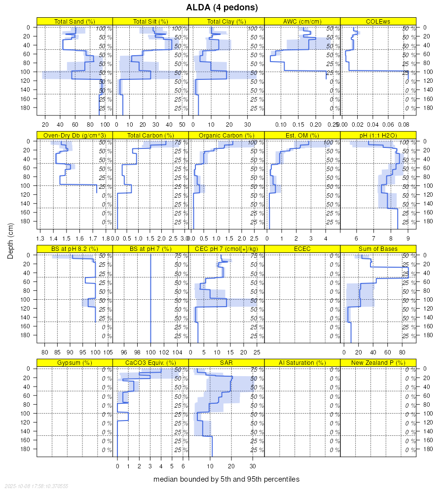
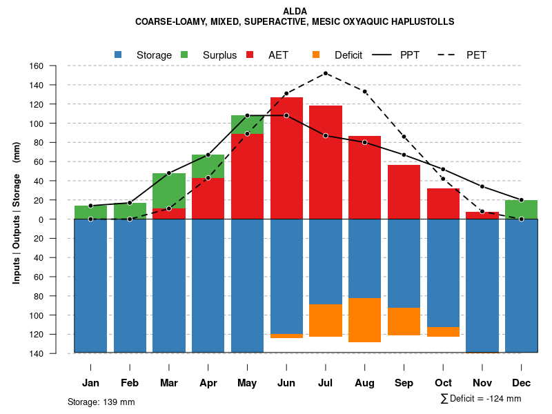
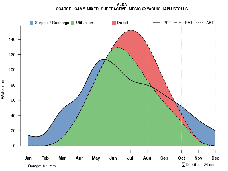
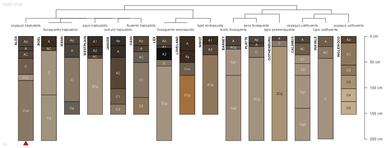
| Alda loam | 3 | 6213 | 94510 | 35bq | co075 | 1974 | 1:24000 |
Westplain-Alda complex | 128 | 2876 | 94491 | 35b3 | co075 | 1974 | 1:24000 |
Alda sandy loam | 2 | 1124 | 94499 | 35bc | co075 | 1974 | 1:24000 |
Alda variant fine sandy loam | 1 | 1324 | 94968 | 35th | co121 | 1982 | 1:24000 |
Alda loam, 0 to 2 percent slopes | 1 | 975 | 497373 | jpk9 | co641 | 1980 | 1:24000 |
Alda-Niwot complex, 0 to 2 percent slopes | 2 | 726 | 497461 | jpn4 | co641 | 1980 | 1:24000 |
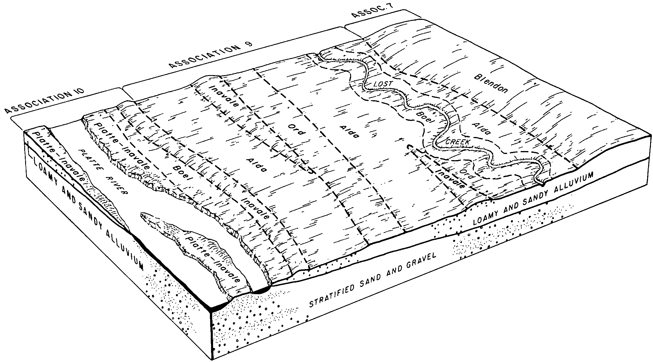
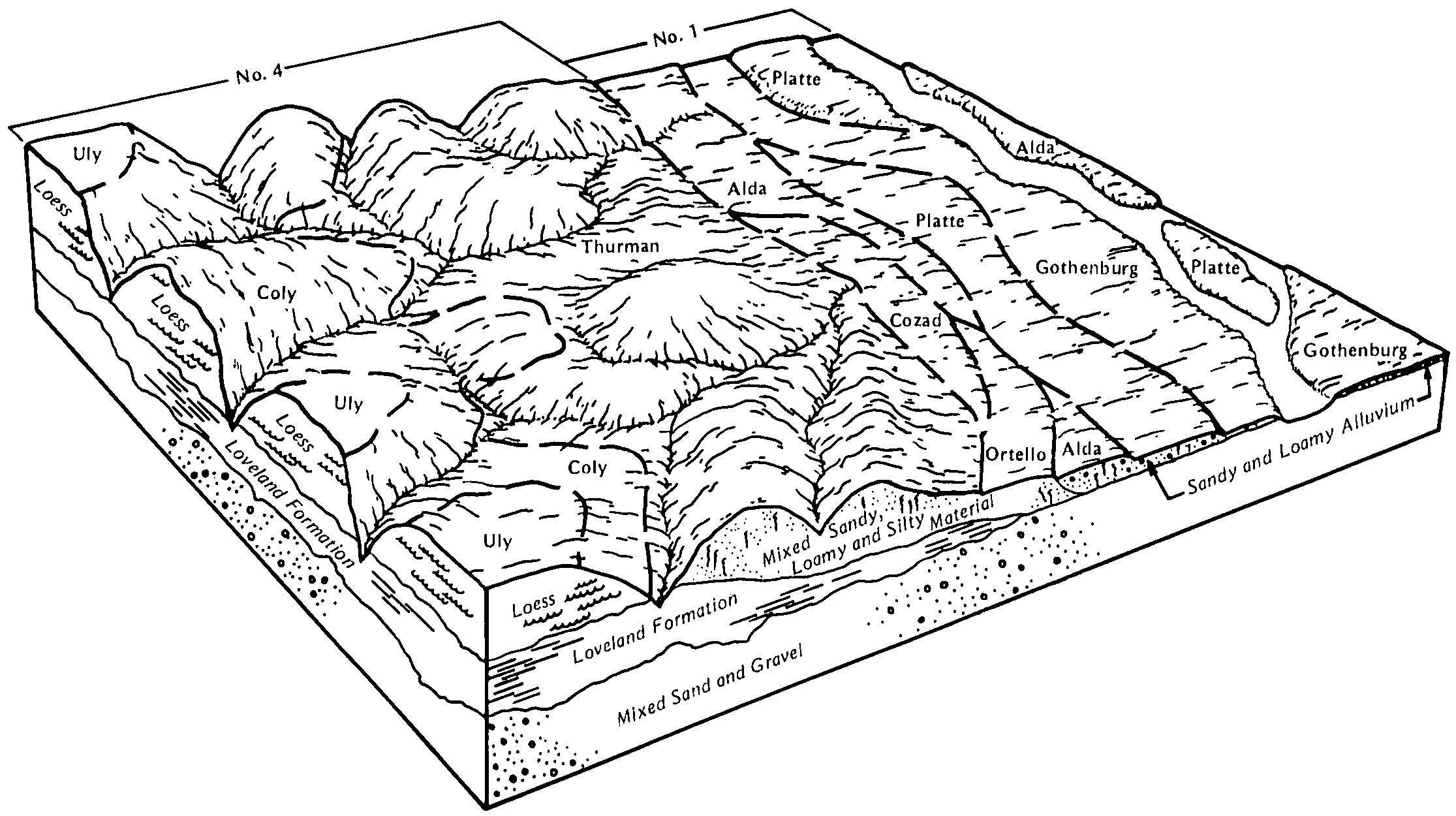
Platte-Alda complex, occasionally flooded | 8567 | 6238 | 1700073 | 1v222 | ne019 | 1967 | 1:20000 |
Alda loam, rarely flooded | 8402 | 3479 | 1700028 | 1v20m | ne019 | 1967 | 1:20000 |
Alda fine sandy loam, rarely flooded | 8400 | 1025 | 1700027 | 1v20l | ne019 | 1967 | 1:20000 |
Alda fine sandy loam, 0 to 2 percent slopes, occasionally flooded | 8401 | 2345 | 1691259 | 2y227 | ne023 | 1979 | 1:20000 |
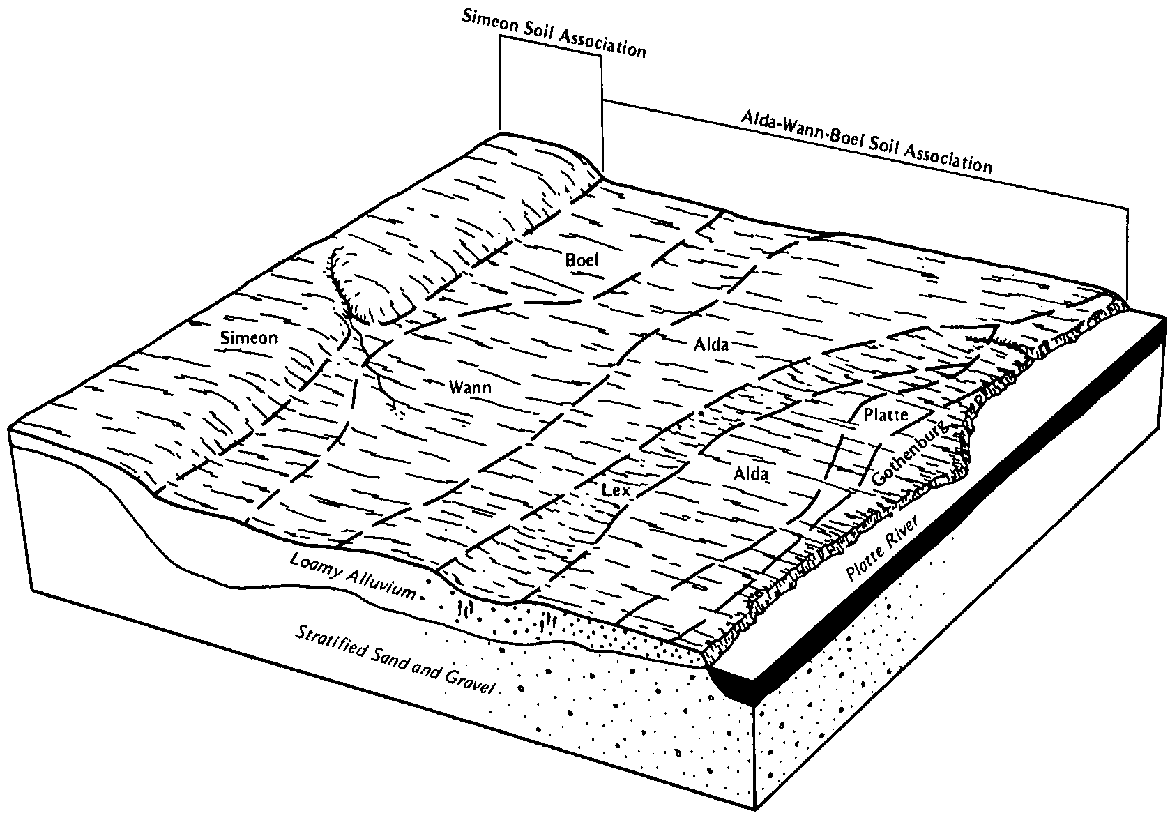
Boel-Alda complex, occasionally flooded | 8424 | 1202 | 1691265 | 1trwy | ne023 | 1979 | 1:20000 |
Alda-Platte complex, occasionally flooded | 8408 | 24 | 2216025 | 2dcyp | ne025 | 1981 | 1:20000 |
Alda loam, 0 to 2 percent slopes, occasionally flooded | 8403 | 3208 | 427872 | 2y228 | ne037 | 1980 | 1:20000 |
Alda fine sandy loam, 0 to 2 percent slopes, occasionally flooded | 8401 | 1304 | 427871 | 2y227 | ne037 | 1980 | 1:20000 |
Alda loam, rarely flooded | 8402 | 955 | 1699654 | 1v1mk | ne047 | 1975 | 1:20000 |
Platte-Alda complex, occasionally flooded | 8567 | 57 | 2228812 | 2dt85 | ne047 | 1975 | 1:20000 |
Alda fine sandy loam, 0 to 2 percent slopes, occasionally flooded | 8401 | 1269 | 426868 | 2y227 | ne053 | 1975 | 1:20000 |
Alda loam, 0 to 2 percent slopes, occasionally flooded | 8403 | 801 | 426869 | 2y228 | ne053 | 1975 | 1:20000 |
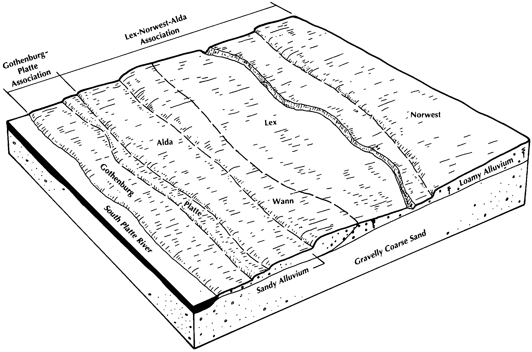
Alda-Platte-Lex complex, occasionally flooded | 8410 | 1787 | 1710932 | 1vfcc | ne055 | 2007 | 1:12000 |
Platte and Alda soils, frequently flooded | 8560 | 1729 | 1710963 | 1vfdc | ne055 | 2007 | 1:12000 |
Alda-Platte fine sandy loams, occasionally flooded | 8409 | 603 | 1710931 | 1vfcb | ne055 | 2007 | 1:12000 |
Alda-Platte complex, occasionally flooded | 8408 | 283 | 1710930 | 1vfc9 | ne055 | 2007 | 1:12000 |
Alda loam, 0 to 2 percent slopes, occasionally flooded | 8403 | 5 | 2217110 | 2y228 | ne055 | 2007 | 1:12000 |
Alda loam, rarely flooded | 8402 | 7705 | 1700097 | 1v22v | ne079 | 2003 | 1:12000 |
Platte-Alda loams, channeled, frequently flooded | 8568 | 641 | 1700170 | 1v256 | ne079 | 2003 | 1:12000 |
Alda sandy loam, rarely flooded | 8404 | 606 | 1700096 | 1v22t | ne079 | 2003 | 1:12000 |
Alda loam, occasionally flooded | 8403 | 1470 | 1692138 | 1tst3 | ne081 | 1982 | 1:20000 |
Alda sandy loam, occasionally flooded | 8405 | 112 | 2218799 | 2dgv5 | ne081 | 1982 | 1:20000 |
Alda loam, rarely flooded | 8402 | 7287 | 1691833 | 1tsh8 | ne099 | 1982 | 1:20000 |
Alda fine sandy loam, occasionally flooded | 8401 | 4258 | 1698868 | 1v0t6 | ne101 | 1990 | 1:20000 |
Platte-Alda complex, occasionally flooded | 8567 | 16044 | 1699211 | 1v158 | ne111 | 1971 | 1:24000 |
Alda soils, occasionally flooded | 8406 | 2397 | 1699137 | 1v12w | ne111 | 1971 | 1:24000 |
Alda fine sandy loam, occasionally flooded | 8401 | 182 | 2219721 | 2dhsx | ne111 | 1971 | 1:24000 |
Alda loam, occasionally flooded | 8403 | 6780 | 1709621 | 1vd02 | ne121 | 1978 | 1:20000 |
Alda sandy loam, occasionally flooded | 8405 | 5269 | 1709620 | 1vd01 | ne121 | 1978 | 1:20000 |
Platte-Alda loams, channeled, frequently flooded | 8568 | 2258 | 1709678 | 1vd1x | ne121 | 1978 | 1:20000 |
Platte-Alda complex, occasionally flooded | 8567 | 202 | 2228292 | 2dsqd | ne121 | 1978 | 1:20000 |
Alda sandy loam, rarely flooded | 8404 | 175 | 2228261 | 2dspd | ne121 | 1978 | 1:20000 |
Alda loam, rarely flooded | 8402 | 86 | 2228260 | 2dspc | ne121 | 1978 | 1:20000 |
Alda loam, rarely flooded | 8402 | 697 | 2219467 | 2dhjq | ne137 | 1967 | 1:20000 |
Platte-Alda complex, occasionally flooded | 8567 | 288 | 2219480 | 2dhk4 | ne137 | 1967 | 1:20000 |
Alda loam, occasionally flooded | 8403 | 1075 | 427617 | gbz3 | ne141 | 1984 | 1:20000 |
Alda fine sandy loam, occasionally flooded | 8401 | 3272 | 1692275 | 1tsyj | ne143 | 1967 | 1:20000 |
Platte-Alda complex, occasionally flooded | 8567 | 3042 | 1692312 | 1tszq | ne143 | 1967 | 1:20000 |
Alda loam, occasionally flooded | 8403 | 1004 | 1692276 | 1tsyk | ne143 | 1967 | 1:20000 |
Barney-Alda complex, frequently flooded | 6307 | 1004 | 1692320 | 1tszz | ne143 | 1967 | 1:20000 |
Alda sandy loam, occasionally flooded | 8405 | 61 | 2218988 | 2dh18 | ne143 | 1967 | 1:20000 |
Alda-Platte complex, occasionally flooded | 8408 | 1693 | 1710994 | 1vffc | ne153 | 2007 | 1:12000 |
Platte and Alda soils, frequently flooded | 8560 | 872 | 1711027 | 1vfgf | ne153 | 2007 | 1:12000 |
Alda-Platte-Lex complex, occasionally flooded | 8410 | 34 | 1710996 | 1vfff | ne153 | 2007 | 1:12000 |
Alda fine sandy loam, 0 to 2 percent slopes, occasionally flooded | 8401 | 3064 | 1691411 | 2y227 | ne155 | 1995 | 1:12000 |
Platte and Alda soils, frequently flooded | 8560 | 144 | 2219269 | 2dhbb | ne155 | 1995 | 1:12000 |

