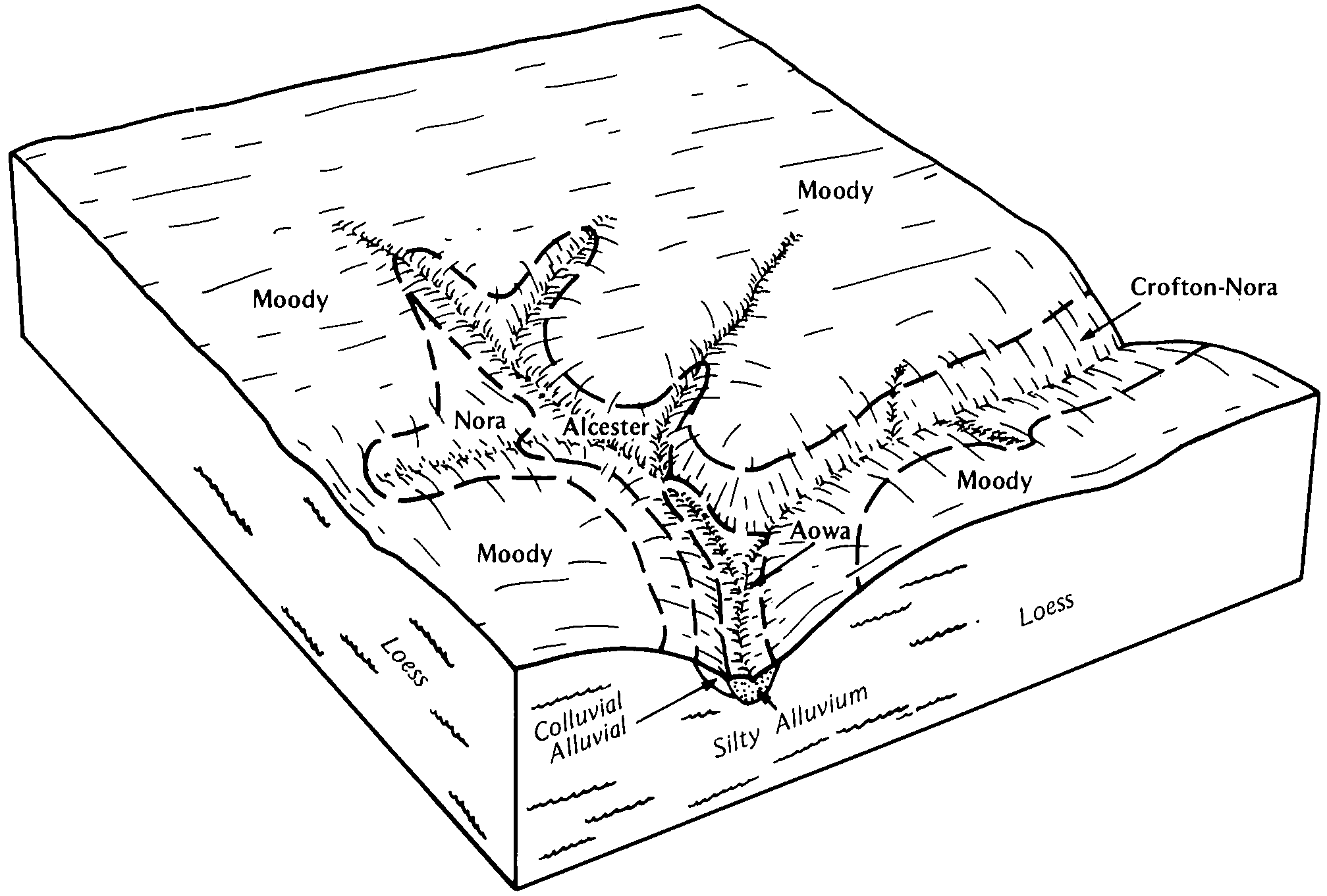
| Alcester silty clay loam, cool, 0 to 2 percent slopes | 37 | 1509 | 409084 | 2ts6r | ia119 | 1973 | 1:15840 |
Alcester silty clay loam, cool, 2 to 6 percent slopes | 37B | 276 | 409085 | 2tv2n | ia119 | 1973 | 1:15840 |
Alcester silty clay loam, cool, 2 to 6 percent slopes | P20B | 141 | 725522 | 2tv2n | mn117 | 2005 | 1:12000 |
Alcester silty clay loam, cool, 0 to 2 percent slopes | P19A | 3803 | 432726 | 2ts6r | mn133 | 2002 | 1:12000 |
Alcester silty clay loam, cool, 2 to 6 percent slopes | P20B | 1158 | 432725 | 2tv2n | mn133 | 2002 | 1:12000 |
Alcester silty clay loam, 2 to 6 percent slopes | 6603 | 11984 | 2862612 | 2tv2m | ne003 | 1975 | 1:20000 |
Alcester silty clay loam, 0 to 2 percent slopes | 6600 | 13 | 2215985 | 2ts6q | ne003 | 1975 | 1:20000 |
Alcester silty clay loam, 0 to 2 percent slopes | 6600 | 16638 | 427020 | 2ts6q | ne011 | 1966 | 1:20000 |
Alcester silty clay loam, 2 to 6 percent slopes | 6603 | 2729 | 2862613 | 2tv2m | ne011 | 1966 | 1:20000 |
Alcester silty clay loam, 2 to 6 percent slopes | 6603 | 28454 | 2862614 | 2tv2m | ne021 | 1978 | 1:20000 |
Alcester silty clay loam, 2 to 6 percent slopes | 6603 | 33823 | 427076 | 2tv2m | ne027 | 1982 | 1:20000 |
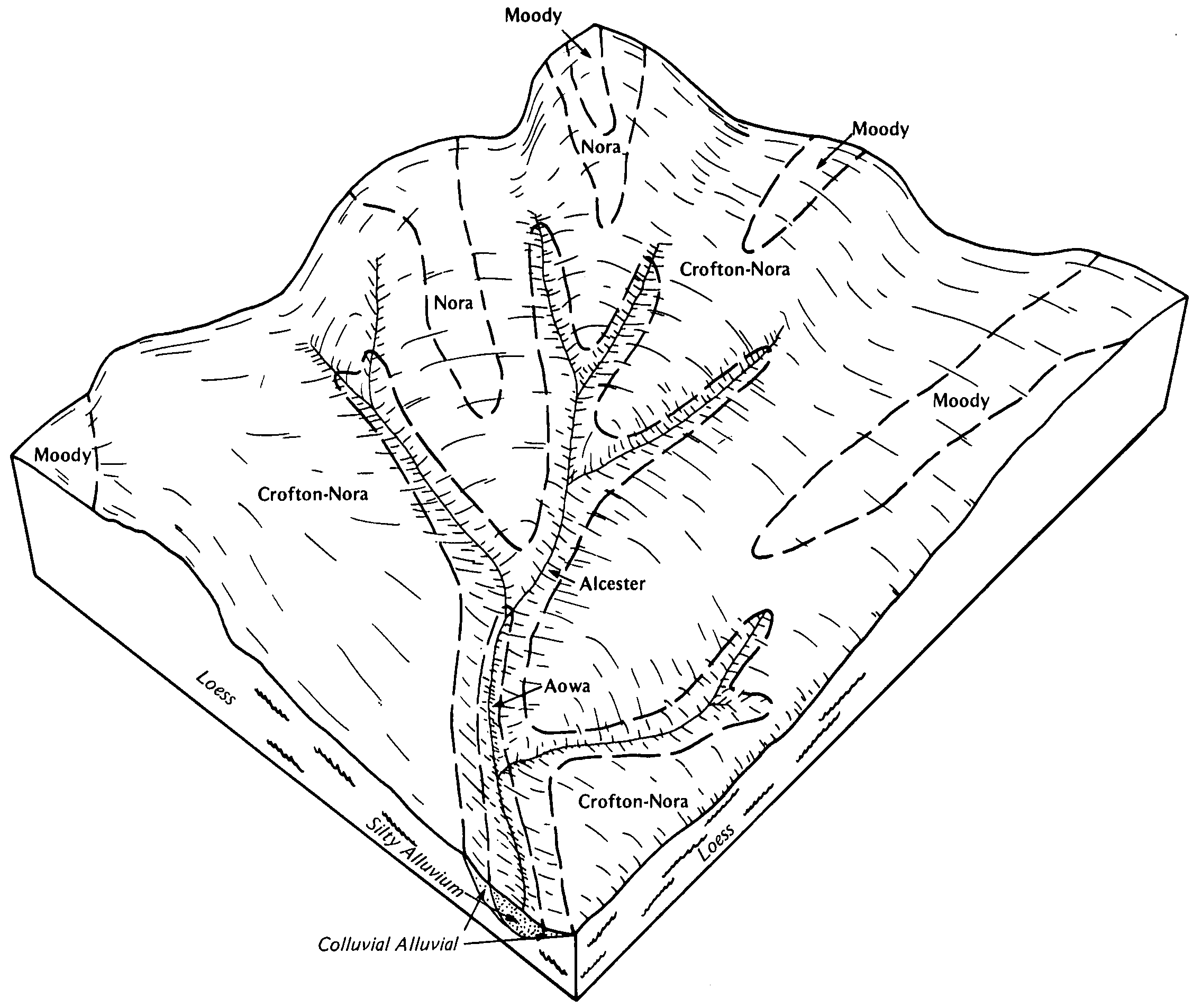
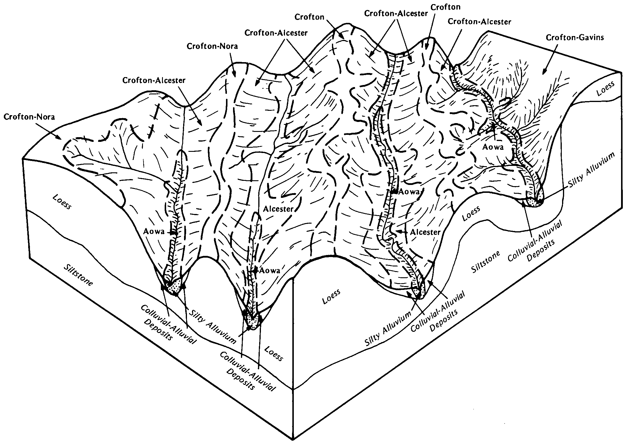
Crofton-Alcester silt loams, 20 to 60 percent slopes | 6787 | 5968 | 427092 | gbf5 | ne027 | 1982 | 1:20000 |
Alcester silty clay loam, 6 to 11 percent slopes | 6601 | 4775 | 427077 | 2ts6s | ne027 | 1982 | 1:20000 |
Alcester silty clay loam, 2 to 6 percent slopes | 6603 | 23229 | 2862618 | 2tv2m | ne037 | 1980 | 1:20000 |
Alcester silty clay loam, 2 to 6 percent slopes | 6603 | 36544 | 2862619 | 2tv2m | ne039 | 1973 | 1:20000 |
Alcester silty clay loam, 2 to 6 percent slopes | 6603 | 15321 | 2862620 | 2tv2m | ne043 | 1972 | 1:20000 |
Alcester silty clay loam, 6 to 11 percent slopes | 6601 | 1184 | 2862655 | 2ts6s | ne043 | 1972 | 1:20000 |
Alcester silty clay loam, 0 to 2 percent slopes | 6600 | 291 | 426739 | 2ts6q | ne043 | 1972 | 1:20000 |
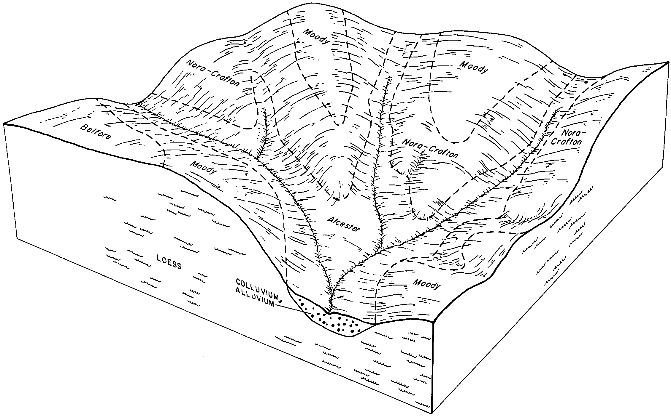
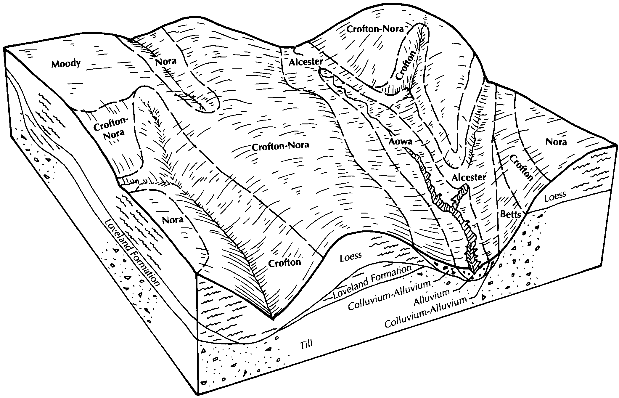
Nora-Alcester silt loams, 11 to 17 percent slopes | 6769 | 32 | 2217040 | 2df0f | ne043 | 1972 | 1:20000 |
Alcester silty clay loam, 2 to 6 percent slopes | 6603 | 32972 | 426653 | 2tv2m | ne051 | 1975 | 1:20000 |
Nora-Alcester silt loams, 11 to 17 percent slopes | 6769 | 5762 | 426692 | gb08 | ne051 | 1975 | 1:20000 |
Alcester silt loam, gullied, 11 to 60 percent slopes | 6602 | 5732 | 426655 | g9z2 | ne051 | 1975 | 1:20000 |
Alcester silty clay loam, 6 to 11 percent slopes | 6601 | 5167 | 426654 | 2ts6s | ne051 | 1975 | 1:20000 |
Nora-Alcester silt loams, 17 to 30 percent slopes | 6770 | 2622 | 426693 | gb09 | ne051 | 1975 | 1:20000 |
Crofton-Alcester silt loams, 20 to 60 percent slopes | 6787 | 363 | 2217062 | 2df14 | ne051 | 1975 | 1:20000 |
Alcester silty clay loam, 2 to 6 percent slopes | 6603 | 19053 | 2862623 | 2tv2m | ne053 | 1975 | 1:20000 |
Alcester silty clay loam, 2 to 6 percent slopes | 6603 | 32848 | 1144198 | 2tv2m | ne107 | 1989 | 1:20000 |
Alcester silty clay loam, 6 to 11 percent slopes | 6601 | 614 | 1144199 | 2ts6s | ne107 | 1989 | 1:20000 |
Alcester silty clay loam, 2 to 6 percent slopes | 6603 | 21920 | 427383 | 2tv2m | ne119 | 1981 | 1:20000 |
Alcester silty clay loam, 2 to 6 percent slopes | 6603 | 54 | 2228982 | 2tv2m | ne125 | 1958 | 1:20000 |
Alcester silty clay loam, 2 to 6 percent slopes | 6603 | 1340 | 2862627 | 2tv2m | ne139 | 1970 | 1:20000 |
Alcester silty clay loam, 2 to 6 percent slopes | 6603 | 20168 | 2862629 | 2tv2m | ne141 | 1984 | 1:20000 |
Alcester silty clay loam, 2 to 6 percent slopes | 6603 | 19327 | 426811 | 2tv2m | ne167 | 1980 | 1:20000 |
Alcester silty clay loam, 2 to 6 percent slopes | 6603 | 30304 | 2862631 | 2tv2m | ne173 | 1966 | 1:20000 |
Alcester silty clay loam, 0 to 2 percent slopes | 6600 | 1404 | 427714 | 2ts6q | ne173 | 1966 | 1:20000 |
Alcester silty clay loam, 2 to 6 percent slopes | 6603 | 9035 | 395523 | 2tv2m | ne177 | 2000 | 1:12000 |
Alcester silty clay loam, 2 to 6 percent slopes | 6603 | 20801 | 2862633 | 2tv2m | ne179 | 1970 | 1:20000 |
Alcester silty clay loam, 0 to 2 percent slopes | 6600 | 200 | 1699846 | 2ts6q | ne183 | 1984 | 1:20000 |
Yankton-Alcester silt loams, 0 to 2 percent slopes | YaA | 5350 | 418294 | g18c | sd009 | 1981 | 1:20000 |
Yankton-Alcester silt loams, 1 to 6 percent slopes | YaB | 4456 | 418295 | g18d | sd009 | 1981 | 1:20000 |
Ethan-Alcester complex, 1 to 6 percent slopes | EhB | 2335 | 418266 | g17g | sd009 | 1981 | 1:20000 |
Ethan-Alcester complex, 1 to 9 percent slopes | EhC | 1862 | 418267 | g17h | sd009 | 1981 | 1:20000 |
Alcester silty clay loam, 0 to 2 percent slopes | AaA | 1662 | 418246 | 2ts6q | sd009 | 1981 | 1:20000 |
Alcester-Chancellor complex | AcA | 625 | 418247 | g16v | sd009 | 1981 | 1:20000 |
Alcester silty clay loam, cool, 0 to 2 percent slopes | AeA | 381 | 445528 | 2ts6r | sd027 | 1995 | 1:24000 |
Alcester silty clay loam, 0 to 2 percent slopes | AcA | 3991 | 416620 | 2ts6q | sd083 | 1971 | 1:20000 |
Alcester silty clay loam, 2 to 6 percent slopes | AcB | 3555 | 416621 | 2tv2m | sd083 | 1971 | 1:20000 |
Alcester and Lamo silty clay loams | Ah | 3001 | 416623 | fzjg | sd083 | 1971 | 1:20000 |
Alcester silty clay loam, channeled | Af | 2931 | 416622 | fzjf | sd083 | 1971 | 1:20000 |
Alcester silty clay loam, cool, 0 to 2 percent slopes | AcA | 2851 | 445996 | 2ts6r | sd099 | 1995 | 1:24000 |
Alcester silty clay loam, cool, 2 to 6 percent slopes | AcB | 2688 | 445997 | 2tv2n | sd099 | 1995 | 1:24000 |
Alcester silty clay loam, cool, 0 to 2 percent slopes | Ac | 1350 | 418300 | 2ts6r | sd101 | 1985 | 1:20000 |
Alcester silty clay loam, cool, 0 to 2 percent slopes | Ac | 2023 | 418201 | 2ts6r | sd125 | 1980 | 1:20000 |
Alcester silty clay loam, 2 to 6 percent slopes | Ae | 26379 | 453676 | 2tv2m | sd127 | 1974 | 1:20000 |