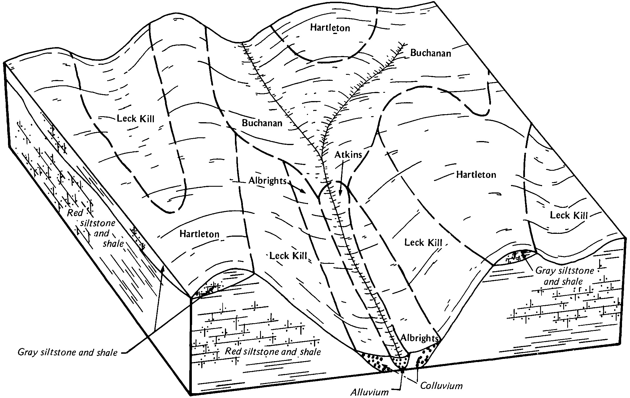
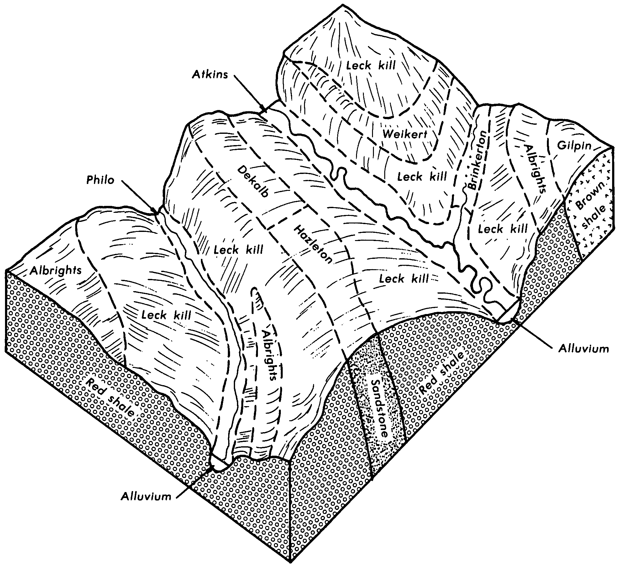
| Albrights silt loam, 3 to 8 percent slopes | AbB | 5160 | 532883 | 2stxm | md023 | 1970 | 1:20000 |
Albrights gravelly silt loam, 0 to 15 percent slopes, very stony | AgC | 4970 | 532885 | 2sgrb | md023 | 1970 | 1:20000 |
Albrights silt loam, 8 to 15 percent slopes | AbC2 | 1160 | 532884 | 2sgr2 | md023 | 1970 | 1:20000 |
Albrights silt loam, 8 to 15 percent slopes | AlC | 2558 | 293134 | 9v0y | ny083 | 1980 | 1:15840 |
Albrights very stony silt loam, 15 to 40 percent slopes | AmD | 2493 | 293137 | 9v11 | ny083 | 1980 | 1:15840 |
Albrights very stony silt loam, 3 to 15 percent slopes | AmC | 1761 | 293136 | 9v10 | ny083 | 1980 | 1:15840 |
Albrights silt loam, 3 to 8 percent slopes | AlB | 1558 | 293133 | 9v0x | ny083 | 1980 | 1:15840 |
Albrights silt loam, 15 to 25 percent slopes | AlD | 910 | 293135 | 9v0z | ny083 | 1980 | 1:15840 |
Albrights silt loam, 8 to 15 percent slopes | AbC | 5334 | 541749 | l5qs | pa009 | 1989 | 1:24000 |
Albrights silt loam, 3 to 8 percent slopes | AbB | 2690 | 541748 | l5qr | pa009 | 1989 | 1:24000 |
Albrights very stony silt loam, 8 to 25 percent slopes | AcD | 1528 | 542314 | l6b0 | pa013 | 1978 | 1:20000 |
Albrights gravelly silt loam, 3 to 8 percent slopes | AbB | 1063 | 542311 | l69x | pa013 | 1978 | 1:20000 |
Albrights very stony silt loam, 3 to 8 percent slopes | AcB | 853 | 542313 | l69z | pa013 | 1978 | 1:20000 |
Albrights gravelly silt loam, 8 to 15 percent slopes | AbC | 502 | 542312 | l69y | pa013 | 1978 | 1:20000 |
Albrights silt loam, 3 to 8 percent slopes | AbB | 669 | 541885 | 2stxm | pa021 | 1978 | 1:20000 |
Albrights silt loam, 8 to 15 percent slopes | AbC | 370 | 541886 | 2sgr2 | pa021 | 1978 | 1:20000 |
Albrights very stony loam, 0 to 8 percent slopes | AcB | 6643 | 539282 | l356 | pa025 | 1960 | 1:20000 |
Albrights silt loam, 3 to 8 percent slopes moderately eroded | AbB2 | 1909 | 539281 | l355 | pa025 | 1960 | 1:20000 |
Albrights silt loam, 0 to 3 percent slopes | AbA | 727 | 539280 | l354 | pa025 | 1960 | 1:20000 |
Albrights very stony loam, 8 to 25 percent slopes | AcD | 205 | 539283 | l357 | pa025 | 1960 | 1:20000 |
Albrights channery loam, 3 to 8 percent slopes moderately eroded | AaB2 | 56 | 539279 | l353 | pa025 | 1960 | 1:20000 |
Albrights channery loam, 0 to 3 percent slopes | AaA | 33 | 539278 | l352 | pa025 | 1960 | 1:20000 |
Albrights silt loam, 8 to 15 percent slopes, extremely stony | AcC | 1706 | 538234 | 2sgrf | pa027 | 1975 | 1:20000 |
Albrights silt loam, 3 to 8 percent slopes | AbB | 1671 | 538231 | 2stxm | pa027 | 1975 | 1:20000 |
Albrights silt loam, 8 to 15 percent slopes | AbC | 1446 | 538232 | 2sgr2 | pa027 | 1975 | 1:20000 |
Albrights silt loam, 0 to 8 percent slopes, extremely stony | AcB | 787 | 538233 | 2vb8m | pa027 | 1975 | 1:20000 |
Albrights gravelly silt loam, 3 to 8 percent slopes, moderately eroded | AaB2 | 3526 | 539436 | l3b5 | pa037 | 1965 | 1:20000 |
Albrights gravelly silt loam, 8 to 15 percent slopes | AaC | 551 | 539437 | l3b6 | pa037 | 1965 | 1:20000 |
Albrights gravelly silt loam, 0 to 3 percent slopes | AaA | 259 | 539435 | l3b4 | pa037 | 1965 | 1:20000 |
Albrights silt loam, 3 to 10 percent slopes, moderately eroded | AbB2 | 1719 | 540690 | l4mm | pa043 | 1967 | 1:15840 |
Albrights silt loam, 0 to 3 percent slopes | AbA | 638 | 540689 | l4ml | pa043 | 1967 | 1:15840 |
Albrights silt loam, 3 to 8 percent slopes | AbgB | 164 | 737593 | srjb | pa043 | 1967 | 1:15840 |
Albrights silt loam, 8 to 25 percent slopes, very stony | AeD | 2232 | 1591135 | 2sgrd | pa051 | 2005 | 1:24000 |
Albrights silt loam, 8 to 15 percent slopes | AbC | 2074 | 1591052 | 2sgr2 | pa051 | 2005 | 1:24000 |
Albrights silt loam, 3 to 8 percent slopes | AbB | 1674 | 1591051 | 2stxm | pa051 | 2005 | 1:24000 |
Albrights silt loam, 0 to 8 percent slopes, very stony | AeB | 1050 | 1591134 | 2sgrc | pa051 | 2005 | 1:24000 |
Albrights very stony silt loam, 8 to 25 percent slopes | AcD | 3265 | 541950 | l5y8 | pa061 | 1974 | 1:20000 |
Albrights silt loam, 3 to 8 percent slopes | AbB | 2516 | 541947 | l5y5 | pa061 | 1974 | 1:20000 |
Albrights silt loam, 8 to 15 percent slopes | AbC | 809 | 541948 | l5y6 | pa061 | 1974 | 1:20000 |
Albrights very stony silt loam, 0 to 8 percent slopes | AcB | 421 | 541949 | l5y7 | pa061 | 1974 | 1:20000 |
Albrights silt loam, 3 to 8 percent slopes | AbB | 2995 | 539043 | 2stxm | pa081 | 1981 | 1:20000 |
Albrights silt loam, 8 to 15 percent slopes | AbC | 1938 | 539044 | 2sgr2 | pa081 | 1981 | 1:20000 |
Albrights silt loam, 8 to 15 percent slopes | AbC | 23957 | 539880 | 2sgr2 | pa083 | 1984 | 1:20000 |
Albrights silt loam, 3 to 8 percent slopes | AbB | 8622 | 539879 | 2stxm | pa083 | 1984 | 1:20000 |
Albrights silt loam, 8 to 15 percent slopes, extremely stony | AdC | 1336 | 539881 | 2sgrf | pa083 | 1984 | 1:20000 |
Albrights silt loam, 3 to 8 percent slopes | AbB | 133 | 538955 | l2tn | pa093 | 1980 | 1:20000 |
Albrights silt loam, 3 to 8 percent slopes | AbB | 1989 | 539587 | l3h1 | pa097 | 1980 | 1:20000 |
Albrights silt loam, 3 to 8 percent slopes | AbB | 6933 | 693894 | r91p | pa099 | 1980 | 1:15840 |
Albrights silt loam, 8 to 15 percent slopes | AbC | 1889 | 693895 | r91q | pa099 | 1980 | 1:15840 |
Albrights silt loam, 3 to 8 percent slopes | AbB | 626 | 540778 | l4qg | pa109 | 1980 | 1:20000 |
Albrights silt loam, 3 to 8 percent slopes | AbB | 2542 | 542049 | 2stxm | pa111 | 1977 | 1:20000 |
Albrights silt loam, 0 to 8 percent slopes, very stony | AgB | 1271 | 542051 | 2sgrc | pa111 | 1977 | 1:20000 |
Albrights silt loam, 8 to 15 percent slopes | AbC | 1124 | 542050 | 2sgr2 | pa111 | 1977 | 1:20000 |
Albrights silt loam, 8 to 25 percent slopes, very stony | AgD | 1054 | 542052 | 2sgrd | pa111 | 1977 | 1:20000 |
Albrights silt loam, 3 to 8 percent slopes | AbB | 2001 | 540873 | l4tj | pa119 | 1980 | 1:20000 |
Albrights silt loam, 8 to 25 percent slopes, very stony | AlD | 1181 | 557360 | 2sgrd | pa129 | 2003 | 1:24000 |
Albrights silt loam, 0 to 8 percent slopes, very stony | AlB | 359 | 557361 | 2sgrc | pa129 | 2003 | 1:24000 |
Albrights silt loam, 8 to 15 percent slopes | AbC | 3427 | 539149 | 2sgr2 | pa607 | 1986 | 1:20000 |
Albrights silt loam, 15 to 25 percent slopes | AbD | 1391 | 539150 | l30y | pa607 | 1986 | 1:20000 |
Albrights silt loam, 3 to 8 percent slopes | AbB | 1250 | 539148 | 2stxm | pa607 | 1986 | 1:20000 |
Albrights silt loam, 3 to 8 percent slopes | AbB | 1508 | 1711382 | 2stxm | wv077 | 1955 | 1:20000 |
Albrights silt loam, 8 to 15 percent slopes | AbC | 693 | 1884269 | 2sgr2 | wv077 | 1955 | 1:20000 |
Albrights gravelly silt loam, 0 to 15 percent slopes, very stony | AgC | 10 | 1868675 | 2sgrb | wv077 | 1955 | 1:20000 |
Albrights silt loam, moist, 3 to 8 percent slopes | AbB | 938 | 513953 | 2stxn | wv602 | 1965 | 1:20000 |
Albrights silt loam, moist, 8 to 15 percent slopes | AbC | 130 | 513954 | 2sgr3 | wv602 | 1965 | 1:20000 |
Albrights silt loam, 3 to 8 percent slopes | AbB | 824 | 555853 | lndr | wv608 | 1973 | 1:20000 |
Albrights silt loam, 8 to 15 percent slopes | AbC | 500 | 555854 | lnds | wv608 | 1973 | 1:20000 |