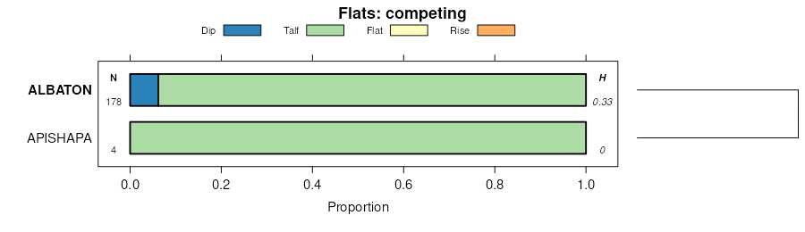
| Albaton silty clay, 0 to 2 percent slopes, occasionally flooded | 156 | 2773 | 406101 | 2xbkt | ia071 | 1968 | 1:20000 |
Albaton silt loam, 0 to 2 percent slopes, occasionally flooded | 157 | 666 | 406102 | 2xbkq | ia071 | 1968 | 1:20000 |
Albaton silty clay, 0 to 2 percent slopes, occasionally flooded | 156 | 15722 | 406737 | 2xbkt | ia085 | 1971 | 1:15840 |
Albaton silt loam, 0 to 2 percent slopes, occasionally flooded | 157 | 3070 | 406738 | 2xbkq | ia085 | 1971 | 1:15840 |
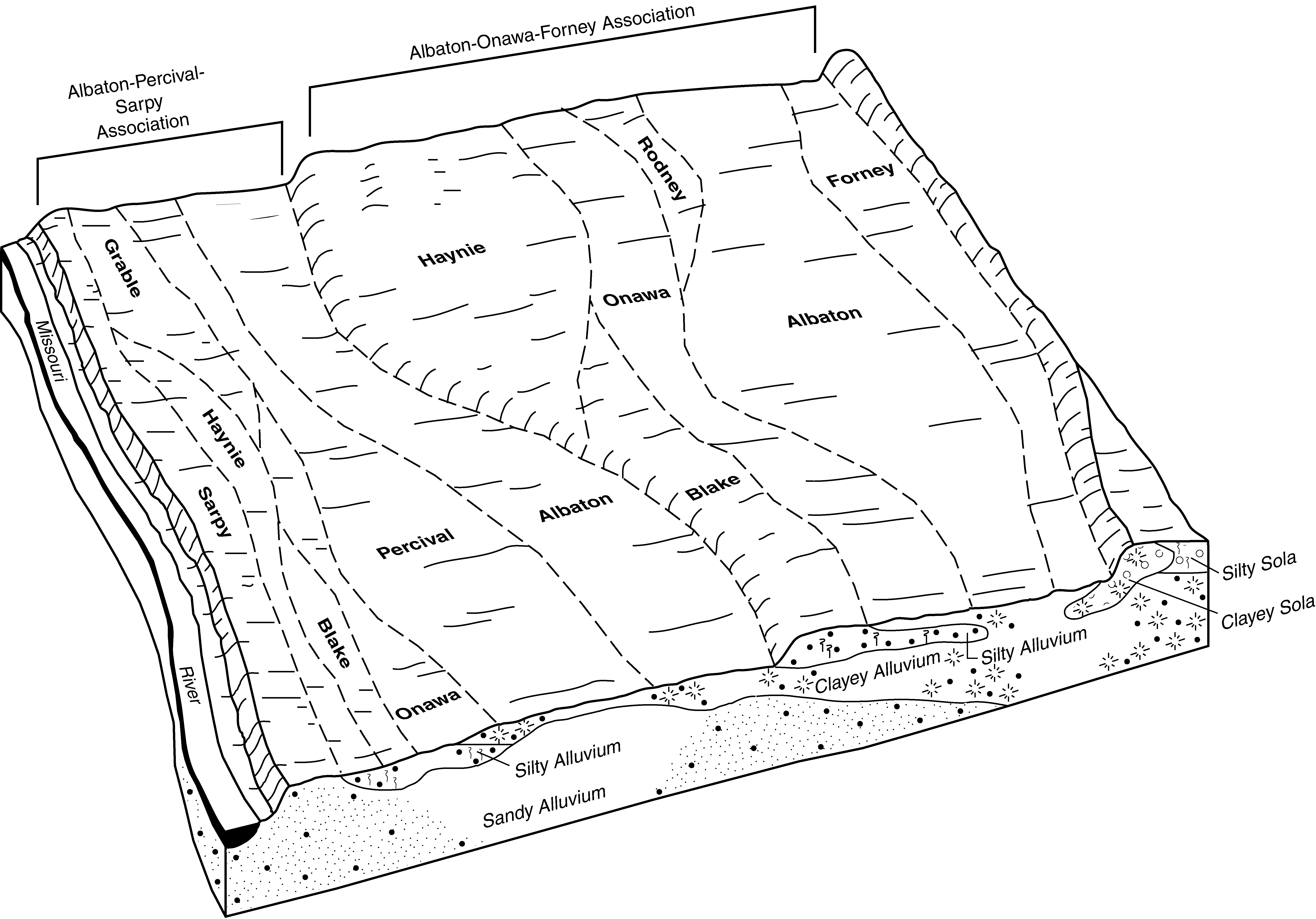
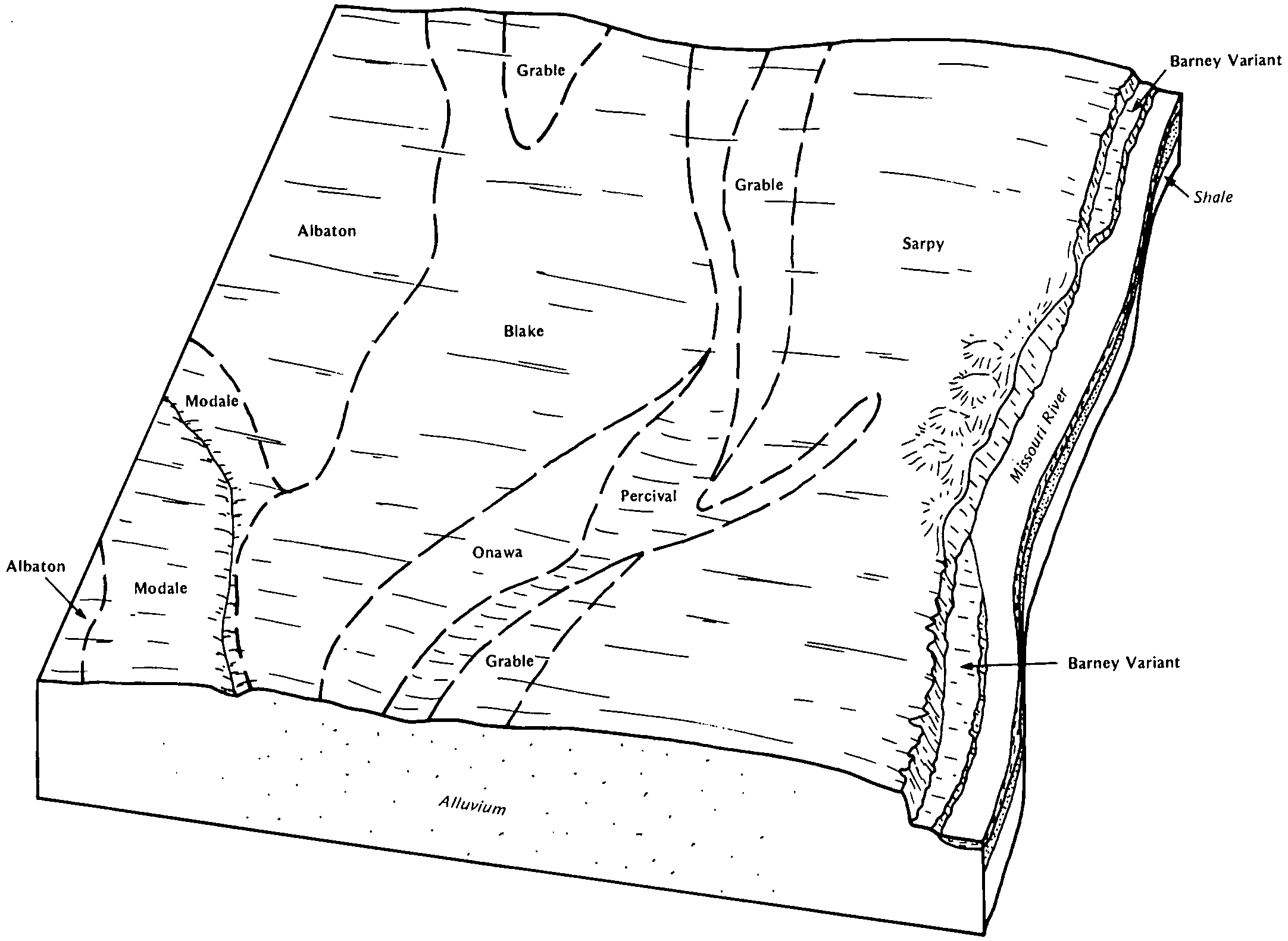
Albaton and Sarpy soils | 315 | 2408 | 406761 | fn8b | ia085 | 1971 | 1:15840 |
Albaton silty clay, 0 to 2 percent slopes, occasionally flooded | 156 | 3960 | 409540 | 2xbkt | ia129 | 1979 | 1:15840 |
Albaton silty clay, 0 to 2 percent slopes, rarely flooded | 156 | 14145 | 447351 | 2xbkv | ia133 | 1994 | 1:12000 |
Albaton silty clay, 0 to 2 percent slopes, occasionally flooded | 1156 | 3401 | 447410 | 2xbkt | ia133 | 1994 | 1:12000 |
Albaton silty clay, depressional, undrained, 0 to 1 percent slopes, frequently flooded | 946 | 1887 | 447398 | 2xbkz | ia133 | 1994 | 1:12000 |
Albaton silty clay, depressional, drained, 0 to 1 percent slopes, frequently flooded | 945 | 637 | 447397 | 2xbky | ia133 | 1994 | 1:12000 |
Albaton silt loam, 0 to 2 percent slopes, rarely flooded | 157 | 542 | 447352 | 2xbkr | ia133 | 1994 | 1:12000 |
Albaton silty clay loam, 0 to 2 percent slopes, rarely flooded | 155 | 267 | 447350 | 2xbkx | ia133 | 1994 | 1:12000 |
Albaton silt loam, 0 to 2 percent slopes, occasionally flooded | 1157 | 206 | 447411 | 2xbkq | ia133 | 1994 | 1:12000 |
Albaton silty clay loam, 0 to 2 percent slopes, occasionally flooded | 1155 | 50 | 447409 | 2xbkw | ia133 | 1994 | 1:12000 |
Albaton silty clay, 0 to 2 percent slopes, rarely flooded | 156 | 374 | 410324 | 2xbkv | ia149 | 1972 | 1:20000 |
Albaton silty clay, 0 to 2 percent slopes, occasionally flooded | 156 | 8134 | 410447 | 2xbkt | ia155 | 1986 | 1:15840 |
Albaton silt loam, 0 to 2 percent slopes, overwash, occasionally flooded | 156+ | 675 | 410448 | 2xbks | ia155 | 1986 | 1:15840 |
Albaton-Urban land complex, 0 to 2 percent slopes, rarely flooded | 4156 | 466 | 410485 | 2xbl1 | ia155 | 1986 | 1:15840 |
Albaton silty clay, 0 to 2 percent slopes, rarely flooded | 156 | 7768 | 401854 | 2xbkv | ia193 | 2003 | 1:12000 |
Onawa-Albaton complex, 0 to 2 percent slopes, rarely flooded | 3146 | 4079 | 741626 | swqf | ia193 | 2003 | 1:12000 |
Percival-Albaton complex, 0 to 2 percent slopes, occasionally flooded | 2515 | 1340 | 741627 | swqg | ia193 | 2003 | 1:12000 |
Albaton silty clay, depressional, drained, 0 to 1 percent slopes, frequently flooded | 945 | 688 | 401983 | 2xbky | ia193 | 2003 | 1:12000 |
Albaton silty clay, occasionally flooded | 7710 | 12 | 1475380 | 1lj7x | ks005 | 1998 | 1:24000 |
Albaton silty clay, occasionally flooded | 7710 | 1172 | 747149 | t2gl | ks043 | 1977 | 1:24000 |
Albaton silty clay, 0 to 2 percent slopes, rarely flooded | 13503 | 710 | 2528311 | 2qmt8 | mo003 | 1986 | 1:24000 |
Albaton silty clay, 0 to 2 percent slopes, rarely flooded | 13503 | 1035 | 2528310 | 2qmt8 | mo021 | 1984 | 1:24000 |
Albaton silty clay, occasionally flooded, wet | 7709 | 667 | 357605 | 2rmhr | ne015 | 1976 | 1:20000 |
Albaton silty clay, 0 to 2 percent slopes, occasionally flooded | 7710 | 4118 | 427801 | 2xbkt | ne021 | 1978 | 1:20000 |
Albaton silty clay, depressional, 0 to 1 percent slopes, frequently flooded | 7711 | 732 | 427802 | 2xbl0 | ne021 | 1978 | 1:20000 |
Albaton silty clay, 0 to 2 percent slopes, occasionally flooded | 7710 | 653 | 1691458 | 2xbkt | ne025 | 1981 | 1:20000 |
Albaton silty clay, rarely flooded | 7712 | 2568 | 427074 | gbdl | ne027 | 1982 | 1:20000 |
Albaton silty clay, frequently flooded | 7711 | 261 | 427075 | gbdm | ne027 | 1982 | 1:20000 |
Albaton silty clay, 0 to 2 percent slopes, occasionally flooded | 7710 | 6892 | 426712 | 2xbkt | ne043 | 1972 | 1:20000 |
Albaton silty clay loam, 0 to 2 percent slopes, occasionally flooded | 7713 | 429 | 426711 | 2xbkw | ne043 | 1972 | 1:20000 |
Albaton silty clay, depressional, 0 to 1 percent slopes, frequently flooded | 7711 | 209 | 426713 | 2xbl0 | ne043 | 1972 | 1:20000 |
Albaton silty clay, occasionally flooded | 7710 | 1642 | 426652 | g9yz | ne051 | 1975 | 1:20000 |
Albaton silty clay, occasionally flooded | 7710 | 250 | 357676 | 2tj80 | ne103 | 1977 | 1:20000 |
Albaton silty clay, occasionally flooded, wet | 7709 | 40 | 3256757 | 2rmhr | ne103 | 1977 | 1:20000 |
Albaton silty clay, occasionally flooded, wet | 7709 | 507 | 2570459 | 2rmhr | ne107 | 1989 | 1:20000 |
Albaton silty clay, occasionally flooded | 7710 | 213 | 849179 | 2tj80 | ne107 | 1989 | 1:20000 |
Albaton silty clay, frequently flooded, wet | 7708 | 74 | 2570458 | 2rmhs | ne107 | 1989 | 1:20000 |
Albaton silty clay, 0 to 2 percent slopes, occasionally flooded | 7710 | 4004 | 1691651 | 2xbkt | ne127 | 1983 | 1:20000 |
Percival-Albaton silty clays, occasionally flooded | 7806 | 861 | 1691690 | 1tsbn | ne127 | 1983 | 1:20000 |
Albaton silty clay, 0 to 2 percent slopes, occasionally flooded | 7710 | 1856 | 1691518 | 2xbkt | ne131 | 1979 | 1:20000 |
Albaton silty clay, 0 to 2 percent slopes, occasionally flooded | 7710 | 1292 | 1691026 | 2xbkt | ne147 | 1967 | 1:20000 |
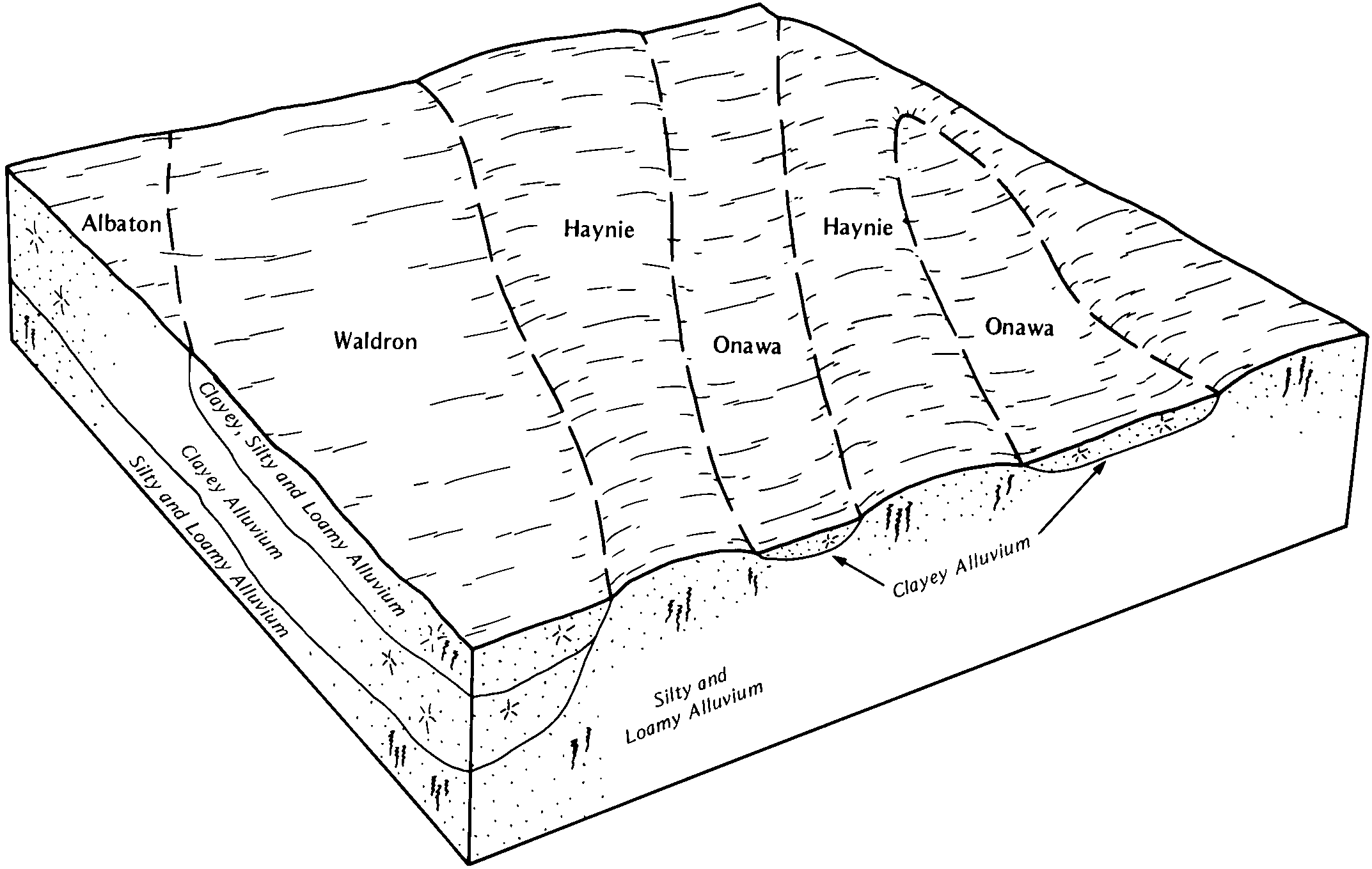
Haynie and Albaton soils, occasionally flooded | 7742 | 881 | 1691034 | 1trnh | ne147 | 1967 | 1:20000 |
Albaton silty clay, 0 to 2 percent slopes, occasionally flooded | 7710 | 1857 | 427692 | 2xbkt | ne173 | 1966 | 1:20000 |
Albaton silty clay loam, 0 to 2 percent slopes, occasionally flooded | 7713 | 488 | 427693 | 2xbkw | ne173 | 1966 | 1:20000 |
Albaton silty clay, depressional, 0 to 1 percent slopes, frequently flooded | 7711 | 15 | 2217280 | 2xbl0 | ne173 | 1966 | 1:20000 |
Albaton silty clay, 0 to 2 percent slopes, occasionally flooded | 7710 | 2814 | 395459 | 2xbkt | ne177 | 2000 | 1:12000 |
Albaton silty clay, depressional, 0 to 1 percent slopes, frequently flooded | 7711 | 767 | 395460 | 2xbl0 | ne177 | 2000 | 1:12000 |
Albaton silty clay, rarely flooded | Ab | 2617 | 2615582 | 2rmht | sd023 | 1980 | 1:20000 |
Albaton silty clay, occasionally flooded, wet | S402A | 2547 | 2615581 | 2rmhr | sd023 | 1980 | 1:20000 |
Albaton silty clay, frequently flooded, wet | S401A | 190 | 2615580 | 2rmhs | sd023 | 1980 | 1:20000 |
Albaton silty clay, 0 to 2 percent slopes | Ac | 3102 | 445526 | gylt | sd027 | 1995 | 1:24000 |
Albaton silty clay, depressional | Ad | 362 | 445527 | gylv | sd027 | 1995 | 1:24000 |
Albaton clay, frequently flooded | Wf | 1537 | 353527 | cvw3 | sd117 | 1977 | 1:24000 |
Albaton silty clay | Ac | 7665 | 453674 | h72n | sd127 | 1974 | 1:20000 |
Albaton silty clay, depressional | Ad | 1852 | 453675 | h72p | sd127 | 1974 | 1:20000 |
Albaton silt loam, overwash | Ab | 1028 | 453673 | h72m | sd127 | 1974 | 1:20000 |