Official Series Description


Lab Data Summary

Aggregate lab data for the ALBANY soil series. This aggregation is based on all pedons with a current taxon name of ALBANY, and applied along 1-cm thick depth slices. Solid lines are the slice-wise median, bounded on either side by the interval defined by the slice-wise 5th and 95th percentiles. The median is the value that splits the data in half. Five percent of the data are less than the 5th percentile, and five percent of the data are greater than the 95th percentile. Values along the right hand side y-axis describe the proportion of pedon data that contribute to aggregate values at this depth. For example, a value of "90%" at 25cm means that 90% of the pedons correlated to ALBANY were used in the calculation. Source: KSSL snapshot . Methods used to assemble the KSSL snapshot used by SoilWeb / SDE

Click the image to view it full size.

Pedons used in the lab summary:

MLRALab IDPedon IDTaxonnameCINSSL / NASIS ReportsLink To SoilWeb GMap
133AS32_0151974-FL063-S32_015Albany3Primary | Supplementary | Taxonomy | Pedon | Water Retention | Correlation | Andic Soil Properties30.9963131,-85.1498413
133AS37_0021975-FL073-S37_002Albany3Primary | Supplementary | Taxonomy | Pedon | Water Retention | Correlation | Andic Soil Properties30.3992424,-84.4839325
133AS57_0371975-FL113-S57_037Albany3Primary | Supplementary | Taxonomy | Pedon | Water Retention | Correlation | Andic Soil Properties30.6968746,-87.0791321
133AS32_0381976-FL063-S32_038Albany3Primary | Supplementary | Taxonomy | Pedon | Water Retention | Correlation | Andic Soil Properties30.5684891,-85.1828232
133AS37_0301978-FL073-S37_030Albany3Primary | Supplementary | Taxonomy | Pedon | Water Retention | Correlation | Andic Soil Properties30.5295277,-84.0493851
133AS66_0301980-FL131-S66_030Albany3Primary | Supplementary | Taxonomy | Pedon | Water Retention | Correlation | Andic Soil Properties30.966877,-86.3744049
133AS33_0121981-FL065-S33_012Albany3Primary | Supplementary | Taxonomy | Pedon | Water Retention | Correlation | Andic Soil Properties30.3392506,-84.0474548
133AS33_0151981-FL065-S33_015Albany3Primary | Supplementary | Taxonomy | Pedon | Water Retention | Correlation | Andic Soil Properties30.3399315,-84.0465393
133AS33_0311982-FL065-S33_031Albany3Primary | Supplementary | Taxonomy | Pedon | Water Retention | Correlation | Andic Soil Properties30.5443249,-83.839653
133AS40_0121984-FL079-S40_012Albany3Primary | Supplementary | Taxonomy | Pedon | Water Retention | Correlation | Andic Soil Properties30.4964619,-83.4164124
133AS07_0141988-FL013-S07_014Albany3Primary | Supplementary | Taxonomy | Pedon | Water Retention | Correlation | Andic Soil Properties30.3783302,-85.0899963
138S12_002S1978FL023002Albany3Primary | Supplementary | Taxonomy | Pedon | Water Retention | Correlation | Andic Soil Properties30.1558781,-82.7284546
138S63_002S1985FL125002Albany3Primary | Supplementary | Taxonomy | Pedon | Water Retention | Correlation | Andic Soil Properties29.9962254,-82.5612488
138S21_011S1987FL041011Albany3Primary | Supplementary | Taxonomy | Pedon | Water Retention | Correlation | Andic Soil Properties29.7199497,-82.826973
138S24_007S1989FL047007Albany3Primary | Supplementary | Taxonomy | Pedon | Water Retention | Correlation | Andic Soil Properties30.5275002,-82.9788895
13802N0660S2002FL121005Albany7Primary | Supplementary | Taxonomy | Pedon | Water Retention | Correlation | Andic Soil Properties30.2110863,-82.9235382
152AS03_0131980-FL005-S03_013Albany2Primary | Supplementary | Taxonomy | Pedon | Water Retention | Correlation | Andic Soil Properties30.2391586,-85.5380173
152AS23_0081989-FL045-S23_008Albany3Primary | Supplementary | Taxonomy | Pedon | Water Retention | Correlation | Andic Soil Properties30.0438976,-85.2010345
152AS34_0021989-FL067-S34_002Albany3Primary | Supplementary | Taxonomy | Pedon | Water Retention | Correlation | Andic Soil Properties29.9282436,-83.3264694
152AS15_0041990-FL029-S15_004Albanyn/aPrimary | Supplementary | Taxonomy | Pedon | Water Retention | Correlation | Andic Soil Properties29.6158314,-83.1391678
153AS16_0101975-FL031-S16_010Albany3Primary | Supplementary | Taxonomy | Pedon | Water Retention | Correlation | Andic Soil Properties30.4544029,-81.6686859
153AS10_0081984-FL019-S10_008Albany3Primary | Supplementary | Taxonomy | Pedon | Water Retention | Correlation | Andic Soil Properties30.1566772,-81.937706
153A00P043799GA299001Albany6Primary | Supplementary | Taxonomy | Pedon | Water Retention | Correlation | Andic Soil Properties31.4638062,-82.6146393
153BS45_0071984-FL089-S45_007Albany3Primary | Supplementary | Taxonomy | Pedon | Water Retention | Correlation | Andic Soil Properties30.70438,-81.6286926
n/a04N0784S04FL039001Albany7Primary | Supplementary | Taxonomy | Pedon | Water Retention | Correlation | Andic Soil Propertiesn/a

Water Balance

Monthly water balance estimated using a leaky-bucket style model for the ALBANY soil series. Monthly precipitation (PPT) and potential evapotranspiration (PET) have been estimated from the 50th percentile of gridded values (PRISM 1981-2010) overlapping with the extent of SSURGO map units containing each series as a major component. Monthly PET values were estimated using the method of Thornthwaite (1948). These (and other) climatic parameters are calculated with each SSURGO refresh and provided by the fetchOSD function of the soilDB package. Representative water storage values (“AWC” in the figures) were derived from SSURGO by taking the 50th percentile of profile-total water storage (sum[awc_r * horizon thickness]) for each soil series. Note that this representation of “water storage” is based on the average ability of most plants to extract soil water between 15 bar (“permanent wilting point”) and 1/3 bar (“field capacity”) matric potential. Soil moisture state can be roughly interpreted as “dry” when storage is depleted, “moist” when storage is between 0mm and AWC, and “wet” when there is a surplus. Clearly there are a lot of assumptions baked into this kind of monthly water balance. This is still a work in progress.

Click the image to view it full size.


Click the image to view it full size.

Sibling Summary

Siblings are those soil series that occur together in map units, in this case with the ALBANY series. Sketches are arranged according to their subgroup-level taxonomic structure. Source: SSURGO snapshot , parsed OSD records and snapshot of SC database .

Click the image to view it full size.

Select annual climate data summaries for the ALBANY series and siblings. Series are sorted according to hierarchical clustering of median values. Source: SSURGO map unit geometry and 1981-2010, 800m PRISM data .

Click the image to view it full size.

Geomorphic description summaries for the ALBANY series and siblings. Series are sorted according to hierarchical clustering of proportions and relative hydrologic position within an idealized landform (e.g. top to bottom). Most soil series (SSURGO components) are associated with a hillslope position and one or more landform-specific positions: hills, mountain slopes, terraces, and/or flats. Proportions can be interpreted as an aggregate representation of geomorphic membership. The values printed to the left (number of component records) and right (Shannon entropy) of stacked bars can be used to judge the reliability of trends. Small Shannon entropy values suggest relatively consistent geomorphic association, while larger values suggest lack thereof. Source: SSURGO component records .

Click the image to view it full size.

Click the image to view it full size.

There are insufficient data to create the 3D mountains figure.

Click the image to view it full size.

Click the image to view it full size.

Competing Series

Soil series competing with ALBANY share the same family level classification in Soil Taxonomy. Source: parsed OSD records and snapshot of the SC database .

Click the image to view it full size.

Select annual climate data summaries for the ALBANY series and competing. Series are sorted according to hierarchical clustering of median values. Source: SSURGO map unit geometry and 1981-2010, 800m PRISM data .

There are insufficient data to create the annual climate figure.

Geomorphic description summaries for the ALBANY series and competing. Series are sorted according to hierarchical clustering of proportions and relative hydrologic position within an idealized landform (e.g. top to bottom). Proportions can be interpreted as an aggregate representation of geomorphic membership. Most soil series (SSURGO components) are associated with a hillslope position and one or more landform-specific positions: hills, mountain slopes, terraces, and/or flats. The values printed to the left (number of component records) and right (Shannon entropy) of stacked bars can be used to judge the reliability of trends. Shannon entropy values close to 0 represent soil series with relatively consistent geomorphic association, while values close to 1 suggest lack thereof. Source: SSURGO component records .

There are insufficient data to create the 2D hillslope position figure.

There are insufficient data to create the 3D hills figure.

There are insufficient data to create the 3D mountains figure.

There are insufficient data to create the 3D terrace figure.

There are insufficient data to create the 3D flats position figure.

Soil series sharing subgroup-level classification with ALBANY, arranged according to family differentiae. Hovering over a series name will print full classification and a small sketch from the OSD. Source: snapshot of SC database .

Block Diagrams

Click a link below to display the diagram. Note that these diagrams may be from multiple survey areas.

  1. FL-2011-05-31-01 | Bradford County - 1991

    Pattern of soils on a gently rolling landscape near major drainageways (Soil Survey of Bradford County, Florida; 1991).

  2. FL-2011-05-31-11 | City of Jacksonville, Duval County - 1978

    Typical pattern of soils and parent material in an area of the Pelham-Mascotte/Sapelo-Surrency general soil map unit. Soils of this map unit are dominantly used for the production of pine trees. In the central part of the county, many areas are used for urban development (Soil Survey of City of Jacksonville, Duval County, Florida; 1978).

  3. FL-2011-05-31-13 | Nassau County - 1991

    Typical pattern of soils and parent material in an area of the Albany-Blanton-Penny and Osler-Ousley-Mandarin map units (Soil Survey of Nassau County, Florida; 1991).

  4. FL-2012-04-26-16 | Union County - October 1991

    Pattern of soils on a gently rolling landscape near major drainageways (Soil Survey of Union County, Florida; October 1991).

Map Units

Map units containing ALBANY as a major component. Limited to 250 records.

Map Unit Name Symbol Map Unit Area (ac) Map Unit Key National Map Unit Symbol Soil Survey Area Publication Date Map Scale
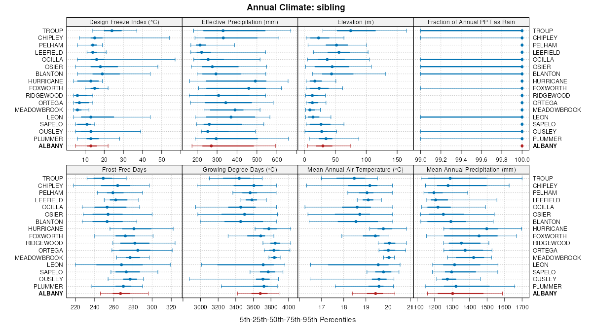
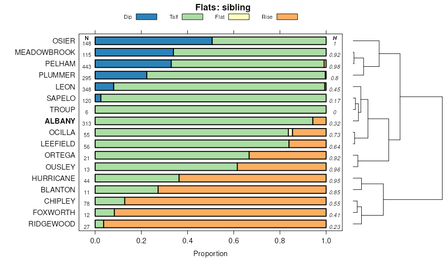
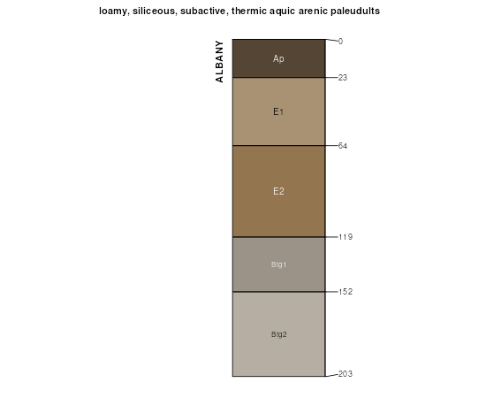
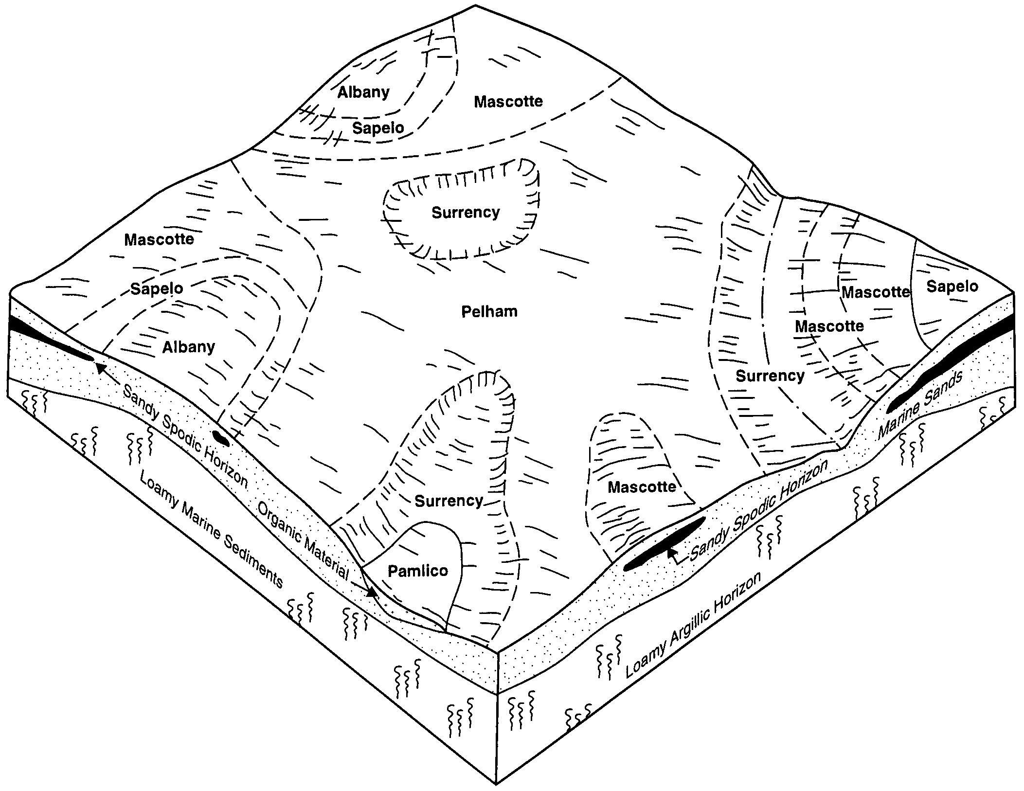
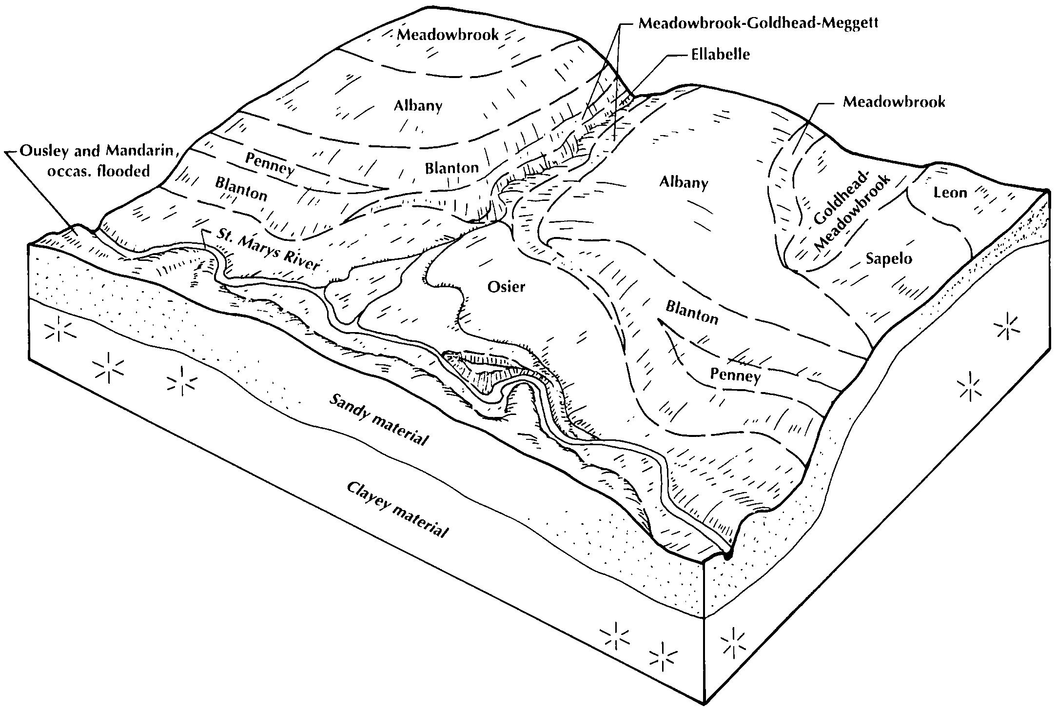
Albany loamy fine sand, 0 to 4 percent slopesAbB882329778c250al06719861:20000
Ocilla-Albany complex, 0 to 2 percent slopesOiA4137330416c2tlal06920021:24000
Albany fine sand, 0 to 5 percent slopes54577514449111khk1fl00319911:20000
Albany sand, 0 to 2 percent slopes1287873207972xnrcfl00519821:20000
Albany sand, 2 to 5 percent slopes21261320807brtmfl00519821:20000
Albany fine sand, 0 to 5 percent slopes25334631614p67nfl00719881:15840
Albany loamy sand, 0 to 5 percent slopes2948214810012ttkxfl01319971:20000
Albany fine sand, 0 to 5 percent slopes192501327994g5vfl01919861:24000
Albany fine sand, 0 to 5 percent slopes, occasionally flooded414751328314g6wfl01919861:24000
Albany fine sand, 0 to 5 percent slopes1256807974282v178fl02319811:24000
Albany fine sand, occasionally flooded2470797439vrsvfl02319811:24000
Albany-Ridgewood complex6889414211341jpt1fl02919981:24000
Garcon-Ousley-Albany complex, occasionally flooded7254514211391jpt6fl02919981:24000
Urban land-Hurricane-Albany complex, 0 to 5 percent slopes759340738887ssw2fl03119961:24000
Albany fine sand, 0 to 5 percent slopes24360738814sssqfl03119961:24000
Hurricane and Albany soils, 0 to 5 percent slopes, occasionally flooded47453014253531jv64fl03319981:24000
Albany sand, 0 to 5 percent slopes43136014253492w4gtfl03319981:24000
Albany fine sand2278814770711ll0gfl03719901:20000
Albany-Blanton complex, 0 to 5 percent slopes2796613815421hclwfl03920061:12000
Bonifay-Albany-Centenary complex, 0 to 5 percent slopes10472513815501hcm4fl03920061:12000
Albany-Ocilla-Chipley complex, 0 to 5 percent slopes101422514218171jqj2fl03920061:12000
Albany-Ousley-Pelham complex, 0 to 5 percent slopes, occasionally flooded3236813815431hclxfl03920061:12000
Albany-Garcon-Bibb complex, 0 to 5 percent slopes, occasionally flooded94213014080951j87ffl03920061:12000
Albany fine sand, 0 to 5 percent slopes1245403217952v178fl04119891:20000
Albany sand21034914727231lfh6fl04519971:24000
Albany fine sand, 0 to 5 percent slopes22683011488152v178fl04719951:24000
Albany sand257601017235134j1fl05919711:12000
Albany sand, 0 to 5 percent slopes2887014249222w4gtfl06319771:20000
Albany sand, 0 to 2 percent slopes20157807004832wywxfl06519841:20000
Albany-Ridgewood complex, 0 to 5 percent slopes278500886584yrkhfl06719931:24000
Albany-Ousley-Meadowbrook complex, 0 to 5 percent slopes, occasionally flooded446490886602yrl2fl06719931:24000
Garcon-Albany-Meadowbrook complex, 0 to 5 percent slopes, occasionally flooded435100886601yrl1fl06719931:24000
Albany loamy sand, 0 to 2 percent slopes11882514544162wz2hfl07319891:20000
Albany-Urban land complex, 0 to 2 percent slopes268014544272wz2ffl07319891:20000
Ousley-Albany complex, occasionally flooded4227014140851jggnfl07519901:24000
Hurricane, Leon, and Albany soils4616355322735btttfl07720041:24000
Albany sand, 0 to 5 percent slopes2115053227062w4gtfl07720041:24000
Albany-Blanton complex, 0 to 5 percent slopes10110016727871t4nwfl07720041:24000
Albany sand, 0 to 5 percent slopes24222013802942w4gtfl07919881:15840
Albany fine sand, 0 to 5 percent slopes5187601329414gbffl08919891:15840
Albany loamy sand, 0 to 5 percent slopes34217014447162ttkxfl09119891:20000
Albany loamy sand, 0 to 5 percent slopes154608237482ttkxfl11319781:24000
Hurricane, Albany, and Chipley soils, 0 to 3 percent slopes266473102334013bvzfl12120031:24000
Ocilla-Albany-Blanton complex, 0 to 5 percent slopes25583102332113bvcfl12120031:24000
Osier-Bibb-Albany complex, frequently flooded693423102338313bxcfl12120031:24000
Chipley-Foxworth-Albany complex, 0 to 5 percent slopes452386102335913bwlfl12120031:24000
Sapelo-Mascotte-Albany complex, frequently flooded391750102335313bwdfl12120031:24000
Albany sand, 0 to 5 percent slopes24546514252182w4gtfl12319981:24000
Albany-Surrency, depressional, complex, 0 to 3 percent slopes29180014252231jv1yfl12319981:24000
Albany fine sand, 0 to 5 percent slopes2658014145852v178fl12519891:15840
Albany-Pactolus loamy sands, 0 to 5 percent slopes16570323978bw3xfl13119851:20000
Albany loamy sand732160324045bw62fl13119851:20000
Chipley-Albany-Hurricane complex, 0 to 5 percent slopes551051023984742lht4fl13320091:12000
Albany-Ocilla complex, 0 to 5 percent slopes, occasionally flooded54734023984732lht3fl13320091:12000
Albany, Chipley, Leon complex, 0 to 5 percent slopes9484023984622lhsrfl13320091:12000
Albany-Ocilla complex, 5 to 8 percent slopes56146023984752lht5fl13320091:12000
Albany sand, 0 to 2 percent slopesAdA148253245162wywxga03119651:20000
Albany sand, 0 to 2 percent slopesAdA11453246142wywxga09519651:20000
Albany sand, 0 to 2 percent slopesAbA781017010871v33sga10320071:24000
Albany and Chipley soils, 0 to 3 percent slopesAHA6570324746bwxpga10719931:20000
Albany sand, 0 to 2 percent slopesAdA203253248342wywxga18519751:20000
Albany sand, 0 to 2 percent slopesAdA1256012491445zhga22919651:20000
Albany loamy fine sand, 0 to 2 percent slopesAsA188012491545zjga22919651:20000
Albany loamy sand, 0 to 2 percent slopesAbA156025802441vrx0ga25120111:24000
Albany sand, 0 to 2 percent slopesAoA5003249242wywxga27719791:20000
Albany-Leefield complex, 0 to 3 percent slopesAbA261024083472lv2mga29920081:24000
Albany sand, 0 to 2 percent slopesAoA5103250962wywxga32119851:20000
Albany sandAd148931251214665ga60119691:20000
Albany sand, 0 to 2 percent slopesAoA310101251554678ga60219831:20000
Albany sand, 0 to 2 percent slopesAdA70553251362wywxga60319811:20000
Albany sand, 0 to 2 percent slopesAdA20813251812wywxga60819651:20000
Albany loamy fine sand, 0 to 2 percent slopesAsA449325183bxcsga60819651:20000
Albany-Leefield complex, 0 to 3 percent slopesAbA1921026867812rz92ga61120121:24000
Albany fine sandAs1477012536846g4ga61319691:20000
Albany fine sand, 0 to 2 percent slopesAdA992412540246h7ga61619771:20000
Albany sand, 0 to 2 percent slopesAdA119303255152wywxga61719761:20000
Albany-Leefield complex, 0 to 3 percent slopesAfA587626867992rz92ga62620131:24000
Albany-Chipley complex, 0 to 5 percent slopesAcB384626868002rz9pga62620131:24000
Albany sand, 0 to 2 percent slopesAd47553255432wywxga62719701:20000
Albany sand, 0 to 2 percent slopesAoA3433255782wywxga63119781:20000
Albany loamy fine sand, 0 to 2 percent slopesAs1016812579046wrga64419801:20000
Albany sand, 0 to 2 percent slopesAnA24041380924mplsc00919971:24000
Albany loamy sand, 0 to 2 percent slopes10105991322534fm7sc02919801:20000
Albany fine sand, 0 to 2 percent slopesAbA75001297834c1ksc03519851:20000
Barth loamy sandBa28151299414c6nsc04119691:20000
Albany-Pelham-Ocilla associationAC127691325204fwvsc05319751:20000
Albany loamy fine sand, 0 to 2 percent slopesAa73731325234fwysc05319751:20000
Albany-Blanton associationAB27631325194fwtsc05319751:20000
Albany sand, 0 to 2 percent slopesAlA15721308704d5msc07519851:20000
Albany loamy sand, 0 to 6 percent slopesAnB9451313344dnlsc69619881:15840

Map of Series Extent

Approximate geographic distribution of the ALBANY soil series. To learn more about how this distribution was mapped, or to compare this soil series extent to others, use the Series Extent Explorer (SEE) application. Source: generalization of SSURGO geometry .