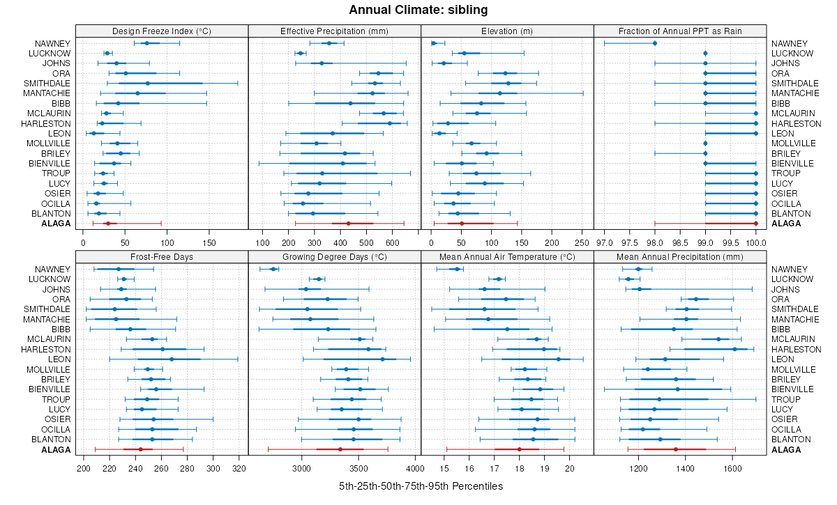
Official Series Description


Lab Data Summary

Aggregate lab data for the ALAGA soil series. This aggregation is based on all pedons with a current taxon name of ALAGA, and applied along 1-cm thick depth slices. Solid lines are the slice-wise median, bounded on either side by the interval defined by the slice-wise 5th and 95th percentiles. The median is the value that splits the data in half. Five percent of the data are less than the 5th percentile, and five percent of the data are greater than the 95th percentile. Values along the right hand side y-axis describe the proportion of pedon data that contribute to aggregate values at this depth. For example, a value of "90%" at 25cm means that 90% of the pedons correlated to ALAGA were used in the calculation. Source: KSSL snapshot . Methods used to assemble the KSSL snapshot used by SoilWeb / SDE

Click the image to view it full size.

Pedons used in the lab summary:

MLRALab IDPedon IDTaxonnameCINSSL / NASIS ReportsLink To SoilWeb GMap
133AS40_0031983-FL079-S40_003Alaga3Primary | Supplementary | Taxonomy | Pedon | Water Retention | Correlation | Andic Soil Properties30.5018883,-83.2944107
133AS87AL-109-187AL109001-pgmAlaga3Primary | Supplementary | Taxonomy | Pedon | Water Retention | Correlation | Andic Soil Properties32.0419502258301,-85.9366683959961
133A81P0555S1981MS059002ALAGA6Primary | Supplementary | Taxonomy | Pedon | Water Retention | Correlation | Andic Soil Properties30.6102238,-88.4878159
138S63_0011985-FL125-S63_001Alaga3Primary | Supplementary | Taxonomy | Pedon | Water Retention | Correlation | Andic Soil Properties29.9964199,-82.5632782
152A40A4796S1955MS059002Alaga4Primary | Supplementary | Taxonomy | Pedon | Water Retention | Correlation | Andic Soil Properties30.659668,-88.5239258

Water Balance

Monthly water balance estimated using a leaky-bucket style model for the ALAGA soil series. Monthly precipitation (PPT) and potential evapotranspiration (PET) have been estimated from the 50th percentile of gridded values (PRISM 1981-2010) overlapping with the extent of SSURGO map units containing each series as a major component. Monthly PET values were estimated using the method of Thornthwaite (1948). These (and other) climatic parameters are calculated with each SSURGO refresh and provided by the fetchOSD function of the soilDB package. Representative water storage values (“AWC” in the figures) were derived from SSURGO by taking the 50th percentile of profile-total water storage (sum[awc_r * horizon thickness]) for each soil series. Note that this representation of “water storage” is based on the average ability of most plants to extract soil water between 15 bar (“permanent wilting point”) and 1/3 bar (“field capacity”) matric potential. Soil moisture state can be roughly interpreted as “dry” when storage is depleted, “moist” when storage is between 0mm and AWC, and “wet” when there is a surplus. Clearly there are a lot of assumptions baked into this kind of monthly water balance. This is still a work in progress.

Click the image to view it full size.


Click the image to view it full size.

Sibling Summary

Siblings are those soil series that occur together in map units, in this case with the ALAGA series. Sketches are arranged according to their subgroup-level taxonomic structure. Source: SSURGO snapshot , parsed OSD records and snapshot of SC database .

Click the image to view it full size.

Select annual climate data summaries for the ALAGA series and siblings. Series are sorted according to hierarchical clustering of median values. Source: SSURGO map unit geometry and 1981-2010, 800m PRISM data .

Click the image to view it full size.

Geomorphic description summaries for the ALAGA series and siblings. Series are sorted according to hierarchical clustering of proportions and relative hydrologic position within an idealized landform (e.g. top to bottom). Most soil series (SSURGO components) are associated with a hillslope position and one or more landform-specific positions: hills, mountain slopes, terraces, and/or flats. Proportions can be interpreted as an aggregate representation of geomorphic membership. The values printed to the left (number of component records) and right (Shannon entropy) of stacked bars can be used to judge the reliability of trends. Small Shannon entropy values suggest relatively consistent geomorphic association, while larger values suggest lack thereof. Source: SSURGO component records .

Click the image to view it full size.

Click the image to view it full size.

There are insufficient data to create the 3D mountains figure.

Click the image to view it full size.

Click the image to view it full size.

Competing Series

Soil series competing with ALAGA share the same family level classification in Soil Taxonomy. Source: parsed OSD records and snapshot of the SC database .

Click the image to view it full size.

Select annual climate data summaries for the ALAGA series and competing. Series are sorted according to hierarchical clustering of median values. Source: SSURGO map unit geometry and 1981-2010, 800m PRISM data .

Click the image to view it full size.

Geomorphic description summaries for the ALAGA series and competing. Series are sorted according to hierarchical clustering of proportions and relative hydrologic position within an idealized landform (e.g. top to bottom). Proportions can be interpreted as an aggregate representation of geomorphic membership. Most soil series (SSURGO components) are associated with a hillslope position and one or more landform-specific positions: hills, mountain slopes, terraces, and/or flats. The values printed to the left (number of component records) and right (Shannon entropy) of stacked bars can be used to judge the reliability of trends. Shannon entropy values close to 0 represent soil series with relatively consistent geomorphic association, while values close to 1 suggest lack thereof. Source: SSURGO component records .

Click the image to view it full size.

Click the image to view it full size.

There are insufficient data to create the 3D mountains figure.

Click the image to view it full size.

Click the image to view it full size.

Soil series sharing subgroup-level classification with ALAGA, arranged according to family differentiae. Hovering over a series name will print full classification and a small sketch from the OSD. Source: snapshot of SC database .

Block Diagrams

No block diagrams are available.

Map Units

Map units containing ALAGA as a major component. Limited to 250 records.

Map Unit Name Symbol Map Unit Area (ac) Map Unit Key National Map Unit Symbol Soil Survey Area Publication Date Map Scale
Alaga loamy sand, 0 to 5 percent slopesAaB2286328057c0chal00119721:20000
Troup-Alaga complex, 0 to 5 percent slopesTgB31103282352s69cal00520011:24000
Alaga loamy sand, 2 to 8 percent slopesAgB1946328404c0qpal01119861:20000
Troup-Alaga complex, 5 to 15 percent slopesTaD10110328479c0t3al01319961:20000
Troup-Alaga complex, 0 to 5 percent slopesAaB33303284392s69cal01319961:20000
Troup-Alaga complex, 5 to 15 percent slopesTgD250330513c2xqal04120051:24000
Alaga loamy sand, 0 to 5 percent slopesAaB12053329614c1zqal06119731:20000
Troup-Alaga complex, 0 to 5 percent slopesTpB14813304982s69cal08719971:24000
Alaga fine sand, 0 to 5 percent slopesAlB159929950342vxxsal09720181:24000
Troup-Alaga complex, 2 to 8 percent slopesTgC13760331327c3rzal10919961:20000
Troup-Alaga complex, 0 to 5 percent slopesTaB97503313682s69cal11319971:24000
Briley-Alaga association, rolling57233565677lzmnar05719761:20000
Alaga fine sand, 3 to 8 percent slopes11286565633lzl7ar05719761:20000
Alaga loamy sand, 1 to 8 percent slopesAgC14115566046m00kar10319691:20000
Alaga loamy sand, 8 to 20 percent slopesAgE5472566047m00lar10319691:20000
Alaga association, rollingALC2620566044m00har10319691:20000
Alaga association, undulatingALB2480566043m00gar10319691:20000
Alaga loamy sand, 0 to 5 percent slopes61676013803281hbbqfl07919881:15840
Alaga loamy sand, moderately wet, 0 to 5 percent slopes64415013803311hbbtfl07919881:15840
Alaga loamy sand, 5 to 8 percent slopes62160013803291hbbrfl07919881:15840
Alaga loamy sand, 8 to 12 percent slopes6321013803301hbbsfl07919881:15840
Alaga loamy fine sand, 0 to 5 percent slopes211707102333513bvtfl12120031:24000
Alaga-Smithdale-Briley(lucy) association, 5 to 40 percent slopesAA324917223751vt8hla02519831:24000
Alaga-Lucy association, undulatingAa78617252731vx8zla07319691:24000
Alaga loamy sand, 0 to 5 percent slopesAaA1251332201c4p5ms03519761:20000
Alaga complex, 12 to 20 percent slopesAmE5064332249c4qqms03919671:20000
Alaga loamy sand, terrace, 0 to 5 percent slopesAlB4559332248c4qpms03919671:20000
Alaga loamy sand, 0 to 5 percent slopesAgB4010332245c4qlms03919671:20000
Alaga loamy sand, 5 to 8 percent slopesAgC2071332246c4qmms03919671:20000
Alaga loamy sand, 8 to 12 percent slopesAgD1428332247c4qnms03919671:20000
Alaga fine sand, 0 to 5 percent slopesAaB350926421512vxxsms04120121:24000
Alaga loamy sand, 0 to 5 percent slopesAlB3071332919c5fbms07719721:20000
Alaga loamy sand, 0 to 2 percent slopesAl1736333592c641ms11119971:20000
Alaga loamy fine sand, 0 to 3 percent slopes, rarely floodedAg429334038c6lfms12919971:20000
Alaga fine sand, 0 to 5 percent slopesAgB59224034712lp0bms15320081:24000
Alaga sand, 0 to 5 percent slopesAaB70251159223wmfnc07319901:24000
Alaga coarse sand, 0 to 6 percent slopesAlB62031381064mq1sc00919971:24000
Alaga sand, 0 to 4 percent slopesAgB8251319824fbhsc02519891:20000
Alaga sand, moderately wet, 0 to 6 percent slopesAgB13231300814cc5sc04919901:20000
Eustis loamy sand, 0 to 6 percent slopesEuB2921302794ckksc05719671:20000
Eustis loamy sand, 6 to 15 percent slopesEuD981302804cklsc05719671:20000
Alaga sand, 0 to 4 percent slopesAgB120616064901qxp8sc06120051:24000
Alaga-Lucknow complex, 0 to 4 percent slopes, rarely floodedAoB74916064921qxpbsc06120051:24000
Alaga loamy sand, 0 to 4 percent slopesAgB82181304864cs7sc06319721:20000
Alaga sand, 0 to 6 percent slopesAhB9081306004cwxsc06919951:24000
Alaga loamy coarse sand, 0 to 6 percent slopesAgB2177724858702pfrcsc08519691:20000
Alaga-Blanton-Johns complex, 0 to 2 percent slopes, rarely floodedAnB29424858742pfrhsc08519691:20000
Alaga fine sandCh2237575573m9xwtx33919671:20000
Osier-Alaga complex, rarely floodedOc908575599m9yqtx33919671:20000
Bienville-Alaga association, gently undulatingBIB25417374410dklrtx61119801:20000
Alaga loamy sand, 0 to 4 percent slopes1B8151189523zs5va07319781:15840
Alaga fine sand11730119303404hva09319821:15840
Alaga loamy sand, 0 to 6 percent slopes1B3037705256rnw6va17519961:24000
Alaga loamy sand, wet substratum, 2 to 8 percent slopes1B120012085441rjva80019791:15840

Map of Series Extent

Approximate geographic distribution of the ALAGA soil series. To learn more about how this distribution was mapped, or to compare this soil series extent to others, use the Series Extent Explorer (SEE) application. Source: generalization of SSURGO geometry .