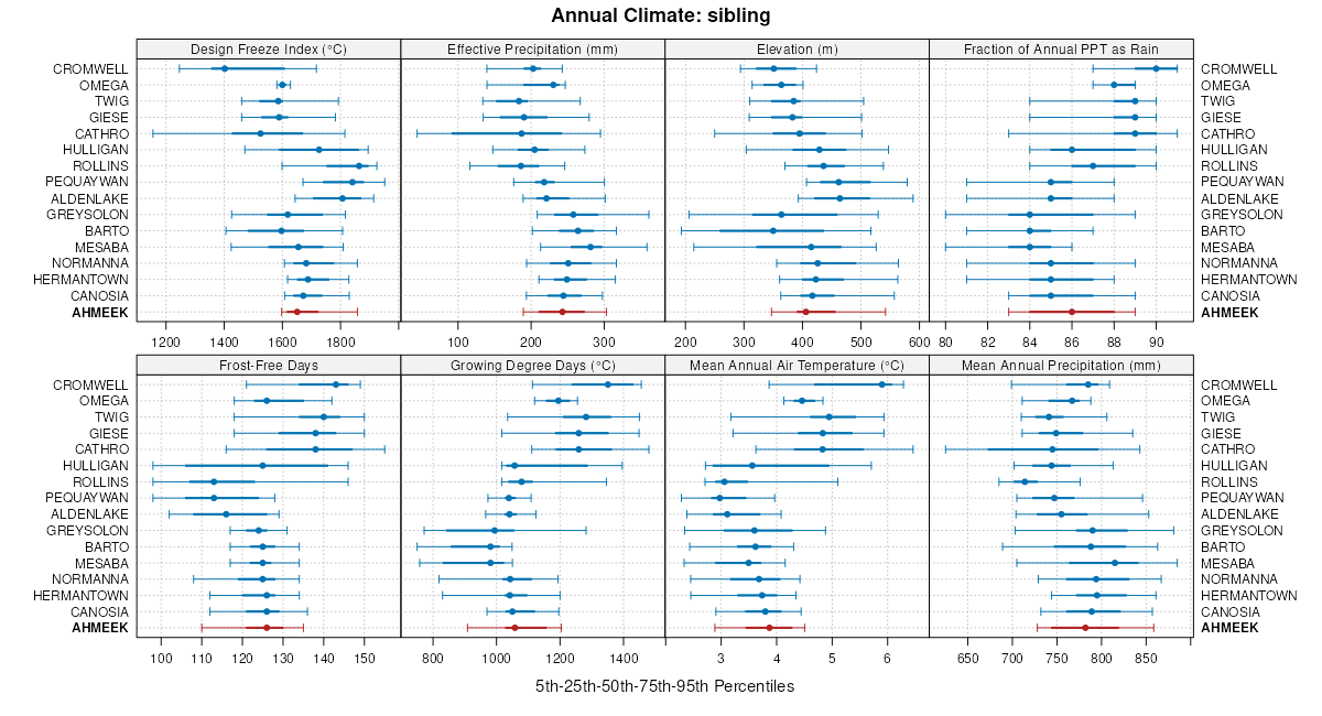
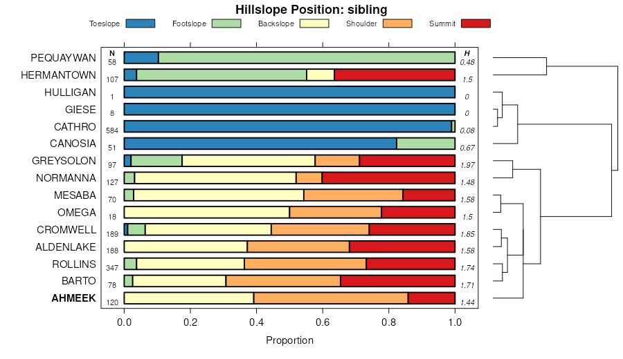
| Ahmeek-Normanna-Canosia complex, 0 to 18 percent slopes | 21C | 49377 | 396345 | 2wcmr | mn017 | 1973 | 1:20000 |
Ahmeek loam, 0 to 2 percent slopes | 21 | 12732 | 396344 | f9f9 | mn017 | 1973 | 1:20000 |
Ahmeek-Omega complex, 2 to 12 percent slopes | 975C | 9659 | 396382 | f9gj | mn017 | 1973 | 1:20000 |
Ahmeek-Canosia complex, 0 to 45 percent slopes | 21E | 3741 | 396346 | 2v6f4 | mn017 | 1973 | 1:20000 |
Ahmeek-Omega complex, 12 to 25 percent slopes | 975E | 1634 | 396383 | f9gk | mn017 | 1973 | 1:20000 |
Ahmeek-Normanna-Cromwell complex, 2 to 15 percent slopes, stony | C173D | 970 | 3462892 | 31n1y | mn017 | 1973 | 1:20000 |
Ahmeek-Omega complex, 0 to 2 percent slopes | 975 | 867 | 396381 | f9gh | mn017 | 1973 | 1:20000 |
Ahmeek-Normanna-Mesaba, stony complex, 4 to 18 percent slopes, very rocky | A1-41D | 9656 | 2774504 | 2rmzf | mn031 | 2013 | 1:24000 |
Ahmeek-Mesaba, stony-Giese, rubbly complex, 0 to 18 percent slopes, very rocky | A2-41D | 3218 | 2774601 | 2rn04 | mn031 | 2013 | 1:24000 |
Ahmeek-Mesaba, stony complex, 18 to 35 percent slopes, very rocky | A1-41F | 1963 | 2774598 | 2rmzg | mn031 | 2013 | 1:24000 |
Ahmeek-Normanna-Canosia complex, 0 to 18 percent slopes | A3-31D | 1737 | 2774524 | 2wcmr | mn031 | 2013 | 1:24000 |
Aldenlake-Ahmeek complex, 8 to 18 percent slopes | F2-41D | 1071 | 2774646 | 2rn2b | mn031 | 2013 | 1:24000 |
Ahmeek-Rock outcrop-Udifluvents, frequently flooded complex, 1 to 70 percent slopes | E1-14F | 765 | 2774506 | 2rn0y | mn031 | 2013 | 1:24000 |
Ahmeek-Udifluvents, frequently flooded-Rock outcrop complex, 1 to 18 percent slopes | E1-9D | 152 | 2774479 | 2rn1d | mn031 | 2013 | 1:24000 |
Ahmeek-Normanna-Cathro, depressional complex 0 to 25 percent slopes, pitted | A3-42D | 73 | 2943740 | 2rmzv | mn031 | 2013 | 1:24000 |
Ahmeek-Canosia complex, 0 to 45 percent slopes | A3-32F | 40 | 2774623 | 2v6f4 | mn031 | 2013 | 1:24000 |
Ahmeek-Rock outcrop-Fluvaquents, frequently flooded complex 0 to 50 percent slopes | E1-10F | 38 | 2774607 | 2rn0x | mn031 | 2013 | 1:24000 |
Ahmeek-Normanna-Mesaba, stony complex, 4 to 18 percent slopes, very rocky | A1-41D | 20122 | 2742117 | 2rmzf | mn075 | 2013 | 1:24000 |
Ahmeek-Normanna-Canosia complex, 0 to 18 percent slopes | A3-31D | 17500 | 2742126 | 2yz88 | mn075 | 2013 | 1:24000 |
Aldenlake-Ahmeek complex, 8 to 18 percent slopes | F2-41D | 16842 | 2742225 | 2yz82 | mn075 | 2013 | 1:24000 |
Ahmeek-Normanna-Cathro, depressional complex 0 to 25 percent slopes, pitted | A3-42D | 7661 | 2742129 | 2rmzv | mn075 | 2013 | 1:24000 |
Ahmeek-Aldenlake complex, 18 to 45 percent slopes | F2-42F | 4986 | 2742226 | 2rn2c | mn075 | 2013 | 1:24000 |
Ahmeek-Mesaba, stony complex, 18 to 35 percent slopes, very rocky | A1-41F | 3723 | 2742118 | 2rmzg | mn075 | 2013 | 1:24000 |
Ahmeek-Mesaba, stony-Giese, rubbly complex, 0 to 18 percent slopes, very rocky | A2-41D | 3365 | 2742138 | 2rn04 | mn075 | 2013 | 1:24000 |
Ahmeek-Canosia complex, 0 to 45 percent slopes | A3-32F | 1581 | 2742127 | 2v6f4 | mn075 | 2013 | 1:24000 |
Ahmeek-Udifluvents, frequently flooded-Rock outcrop complex, 1 to 18 percent slopes | E1-9D | 869 | 2742182 | 2rn1d | mn075 | 2013 | 1:24000 |
Ahmeek-Rock outcrop-Udifluvents, frequently flooded complex, 1 to 70 percent slopes | E1-14F | 863 | 2742179 | 2rn0y | mn075 | 2013 | 1:24000 |
Ahmeek-Rock outcrop-Fluvaquents, frequently flooded complex 0 to 50 percent slopes | E1-10F | 811 | 2742176 | 2rn0x | mn075 | 2013 | 1:24000 |
Ahmeek-Canosia complex, 0 to 25 percent slopes, very rocky | A3-50D | 516 | 2742131 | 2rmzw | mn075 | 2013 | 1:24000 |
Ahmeek-Normanna-Cromwell complex, 2 to 15 percent slopes, stony | C173D | 36360 | 3462691 | 31n1y | mn115 | 2009 | 1:24000 |
Ahmeek-Normanna-Giese, frequently ponded, complex, 0 to 20 percent slopes, stony | C266D | 1844 | 3462732 | 3111l | mn115 | 2009 | 1:24000 |
Ahmeek, stony-Grayling complex, 2 to 20 percent slopes | C285D | 720 | 3462729 | 31119 | mn115 | 2009 | 1:24000 |
Ahmeek-Normanna-Canosia complex, 0 to 18 percent slopes | F138D | 27215 | 449575 | 2wcmr | mn615 | 2007 | 1:24000 |
Ahmeek-Normanna-Cathro, depressional, complex, pitted, 0 to 25 percent slopes | F141D | 8986 | 449578 | h2tj | mn615 | 2007 | 1:24000 |
Ahmeek-Canosia-Rock outcrop complex, 0 to 25 percent slopes | F147D | 7483 | 764971 | tp0h | mn615 | 2007 | 1:24000 |
Ahmeek-Canosia complex, 0 to 45 percent slopes | F139F | 4216 | 449576 | 2v6f4 | mn615 | 2007 | 1:24000 |
Aldenlake-Ahmeek complex, 8 to 18 percent slopes | F144D | 2585 | 449581 | h2tm | mn615 | 2007 | 1:24000 |
Rock outcrop-Ahmeek, bedrock substratum-Barto complex, 4 to 18 percent slopes | F156D | 2135 | 1145761 | 17g81 | mn615 | 2007 | 1:24000 |
Ahmeek-Rock outcrop-Fluvaquents, frequently flooded, complex, 0 to 50 percent slopes | F148F | 1404 | 764970 | tp0g | mn615 | 2007 | 1:24000 |
Urban land-Ahmeek-Normanna complex, 3 to 18 percent slopes | F159D | 1183 | 1424899 | 1jtqh | mn615 | 2007 | 1:24000 |
Ahmeek-Aldenlake complex, 18 to 45 percent slopes | F145F | 824 | 449582 | h2tn | mn615 | 2007 | 1:24000 |
Ahmeek-Normanna-Canosia complex, 0 to 18 percent slopes | F138D | 6508 | 1715852 | 2wcmr | mn619 | 2009 | 1:24000 |
Aldenlake-Ahmeek complex, 8 to 18 percent slopes | F144D | 4926 | 1715858 | 1vlh8 | mn619 | 2009 | 1:24000 |
Ahmeek-Canosia complex, 0 to 45 percent slopes | F139F | 2369 | 1715853 | 2v6f4 | mn619 | 2009 | 1:24000 |
Ahmeek-Aldenlake complex, 18 to 45 percent slopes | F145F | 2154 | 1715859 | 1vlh9 | mn619 | 2009 | 1:24000 |
Ahmeek-Normanna-Cathro, depressional, complex, pitted, 0 to 25 percent slopes | F141D | 1983 | 1715855 | 1vlh5 | mn619 | 2009 | 1:24000 |
Ahmeek-Rock outcrop-Fluvaquents, frequently flooded, complex, 0 to 50 percent slopes | F148F | 27 | 1715862 | 1vlhd | mn619 | 2009 | 1:24000 |
Ahmeek-Normanna-Cromwell complex, 2 to 15 percent slopes, stony | 6173C | 2288 | 3462781 | 31n1y | wi031 | 2005 | 1:12000 |