| Rodie-Shalcleav-Agassiz association | 420 | 4275 | 475030 | hy9k | nv765 | 1986 | 1:24000 |
Agassiz-Croesus-Rubble land association | 1010 | 3945 | 474862 | hy44 | nv765 | 1986 | 1:24000 |
Amene-Ekim-Agassiz assocation | 561 | 2620 | 475056 | hybd | nv765 | 1986 | 1:24000 |
Agassiz-Skutum-Lizzant complex, 25 to 70 percent slopes | DRG | 19795 | 2810262 | 2trdn | ut013 | | 1:24000 |
Senchert-Calfhollow-Agassiz complex, 5 to 35 percent slopes | QuC | 5495 | 2503735 | 2pw0c | ut013 | | 1:24000 |
Starvation-Isbell-Agassiz complex, 15 to 60 percent slopes, very stony | SNF | 2788 | 1428095 | 1jy1l | ut013 | | 1:24000 |
Agassiz-Rock outcrop-Sheep Creek association, 25 to 75 percent slopes, extremely stony | SRG | 687 | 1426064 | 1jvy2 | ut013 | | 1:24000 |
Agassiz-Picayune association, very steep | AGG | 4887 | 481316 | j4vb | ut602 | 1969 | 1:20000 |
Elzinga-Agassiz association, steep | EMF | 855 | 481345 | j4w8 | ut602 | 1969 | 1:20000 |
AGASSIZ-DATEMAN ASSOCIATION, ERODED | ADG2 | 14318 | 482657 | j67l | ut603 | 1968 | 1:20000 |
AGASSIZ-BRADSHAW ASSOCIATION, ERODED | ABG2 | 9508 | 482656 | j67k | ut603 | 1968 | 1:20000 |
BICKMORE-SHEEP CREEK ASSOCIATION, ERODED | BLG2 | 8423 | 482675 | j685 | ut603 | 1968 | 1:20000 |
SHEEP CREEK-AGASSIZ ASSOCIATION, ERODED | SOG2 | 6259 | 482826 | j6f1 | ut603 | 1968 | 1:20000 |
BRADSHAW-AGASSIZ ASSOCIATION, ERODED | BSG2 | 5012 | 482676 | j686 | ut603 | 1968 | 1:20000 |
MULT-AGASSIZ ASSOCIATION | MNE | 3717 | 482772 | j6c9 | ut603 | 1968 | 1:20000 |
AGASSIZ VERY COBBLY SILT LOAM, 6 TO 30 PERCENT SLOPES | AAE | 2927 | 482654 | j67h | ut603 | 1968 | 1:20000 |
AGASSIZ-ELWOOD ASSOCIATION, ERODED | AEG2 | 2717 | 482658 | j67m | ut603 | 1968 | 1:20000 |
PICAYUNE-AGASSIZ ASSOCIATION, ERODED | POG2 | 2554 | 482794 | j6d0 | ut603 | 1968 | 1:20000 |
AGASSIZ VERY COBBLY SILT LOAM, 30 TO 70 PERCENT SLOPES,ERODED | AAG2 | 1817 | 482655 | j67j | ut603 | 1968 | 1:20000 |
POLELINE-AGASSIZ ASSOCIATION, ERODED | PSG2 | 1671 | 482796 | j6d2 | ut603 | 1968 | 1:20000 |
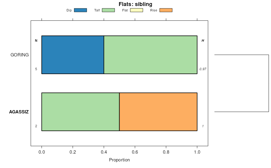
AGASSIZ-GORING ASSOCIATION | AGE | 1548 | 482659 | j67n | ut603 | 1968 | 1:20000 |
HOSKIN-ELZINGA ASSOCIATION, ERODED | HMG2 | 1510 | 482731 | j69z | ut603 | 1968 | 1:20000 |
AGASSIZ-GORING ASSOCIATION, ERODED | AGG2 | 1444 | 482660 | j67p | ut603 | 1968 | 1:20000 |
BICKMORE-AGASSIZ ASSOCIATION, ERODED | BKG2 | 1338 | 482674 | j684 | ut603 | 1968 | 1:20000 |
LUCKY STAR-RED SPUR COMPLEX, 6 TO 30 PERCENT SLOPES | LWE | 1123 | 482764 | j6c1 | ut603 | 1968 | 1:20000 |
MULT-AGASSIZ ASSOCIATION, ERODED | MNG2 | 1081 | 482773 | j6cb | ut603 | 1968 | 1:20000 |
ELWOOD-AGASSIZ ASSOCIATION | EGE | 999 | 482712 | j69c | ut603 | 1968 | 1:20000 |
MULT-LUCKY STAR ASSOCIATION | MSE | 668 | 482774 | j6cc | ut603 | 1968 | 1:20000 |
Agassiz-Rock outcrop complex, 25 to 60 percent slopes | ACF | 8030 | 503800 | jx7m | ut604 | 1980 | 1:24000 |
Mult-Agassiz complex, 10 to 25 percent slopes | MCD | 2340 | 503876 | jxb2 | ut604 | 1980 | 1:24000 |
Agassiz-Mult complex, 10 to 25 percent slopes | AAD | 2030 | 503797 | jx7j | ut604 | 1980 | 1:24000 |
Agassiz-Richville complex, 10 to 60 percent slopes | ABF | 1250 | 503799 | jx7l | ut604 | 1980 | 1:24000 |
Agassiz-Mult complex, 25 to 60 percent slopes | AAF | 1230 | 503798 | jx7k | ut604 | 1980 | 1:24000 |
Richens-Agassiz complex, 25 to 60 percent slopes | RGF | 550 | 503895 | jxbp | ut604 | 1980 | 1:24000 |
Agassiz-Rock outcrop complex, 30 to 70 percent slopes | AbF | 19575 | 482445 | j60r | ut608 | 1981 | 1:24000 |
Agassiz very stony loam, 30 to 70 percent slopes | AaF | 2057 | 482444 | j60q | ut608 | 1981 | 1:24000 |
Calpac-Agassiz complex, 30 to 70 percent slopes | CbF | 1886 | 482476 | j61r | ut608 | 1981 | 1:24000 |
Agassiz-Rock outcrop complex, 40 to 70 percent slopes | AaG | 12030 | 506504 | k01v | ut609 | 1974 | 1:24000 |
Geertsen-Agassiz complex, 30 to 70 percent slopes | GcG | 5005 | 506549 | k039 | ut609 | 1974 | 1:24000 |
Agassiz-Rock outcrop complex, shallow, 40 to 70 percent slopes | AbG | 2320 | 506505 | k01w | ut609 | 1974 | 1:24000 |
Agassiz-Geertsen-Rock outcrop association, very steep | AGG | 1555 | 506503 | k01t | ut609 | 1974 | 1:24000 |
Bradshaw-Agassiz association, steep | BEG | 9795 | 482868 | j6gd | ut612 | 1967 | 1:20000 |
Agassiz association, very steep | AGG | 2573 | 482865 | j6g9 | ut612 | 1967 | 1:20000 |
Horrocks-Agassiz very cobbly loams, 30 to 70 percent slopes | 143 | 16114 | 508187 | k1t4 | ut613 | 1999 | 1:24000 |
Hades-Agassiz-Rock outcrop complex, 30 to 70 percent slopes | 136 | 11611 | 508180 | k1sx | ut613 | 1999 | 1:24000 |
Agassiz-Rock outcrop complex, 30 to 70 percent slopes | 101 | 6240 | 508227 | k1vf | ut613 | 1999 | 1:24000 |
Agassiz-Wallsburg association, very steep | AWF | 608 | 504175 | jxmq | ut622 | 1967 | 1:24000 |
Burgi-Agassiz association, very steep | BXF | 576 | 504202 | jxnl | ut622 | 1967 | 1:24000 |
Agassiz very cobbly loam, 25 to 60 percent slopes | AGF | 446 | 504174 | jxmp | ut622 | 1967 | 1:24000 |
Agassiz, extremely stony-Dateman-Rock outcrop complex, 30 to 70 percent slopes | 582 | 7936 | 3450347 | 2pzwd | ut647 | | 1:24000 |
Limber family-Mult-Agassiz, very stony complex, 5 to 25 percent | 574 | 5770 | 3450343 | 2pzw7 | ut647 | | 1:24000 |
Agassiz, extremely stony-Onkeyo family, rubbly-Bradshaw family association, 30 to 70 percent slopes | R35 | 4851 | 623909 | ny73 | ut647 | | 1:24000 |
Agassiz, extremely stony-Goring association, 6 to 30 percent slopes | 647AGE | 3390 | 3450348 | 30nkr | ut647 | | 1:24000 |
Agassiz channery silt loam, 10 to 40 percent slopes | 75 | 3058 | 756857 | tdkr | ut647 | | 1:24000 |
Mult, dry-Agassiz, very stony complex, 3 to 25 percent slopes | 573 | 2890 | 3450342 | 2pzw6 | ut647 | | 1:24000 |
Agassiz-Bezzant family, very stony-Rock outcrop complex, 30 to 70 percent slopes | 103 | 2764 | 757982 | tfr1 | ut647 | | 1:24000 |
Agassiz channery silt loam, 40 to 70 percent slopes | 78 | 2640 | 757481 | tf6w | ut647 | | 1:24000 |
Agassiz-Abes-Rock outcrop complex, 15 to 70 percent slopes | 104 | 2338 | 757981 | tfr0 | ut647 | | 1:24000 |
AGASSIZ-GORING ASSOCIATION, ERODED | AGG2 | 541 | 3450349 | j67p | ut647 | | 1:24000 |
Bezzant family, very stony-Agassiz association, 30 to 70 percent slopes | 40-78 | 357 | 757990 | tfr9 | ut647 | | 1:24000 |
Agassiz-Abes association, 15 to 70 percent slopes | 70-78 | 198 | 757482 | tf6x | ut647 | | 1:24000 |
Pernty family-Agassiz family-Rock outcrop complex, 40 to 75 percent slopes | 182 | | 581653 | mj80 | ut649 | | 1:24000 |
Agassiz family-Rock outcrop complex, 15 to 50 percent slopes | 104 | | 581646 | mj7s | ut649 | | 1:24000 |
Forsey-Forsey, moderately deep-Agassiz families, association, 30 to 70 percent slopes | 155 | | 581651 | mj7y | ut649 | | 1:24000 |
Pernty family-Agassiz family-Rock outcrop complex, 5 to 40 percent slopes | 181 | | 581655 | mj82 | ut649 | | 1:24000 |
Agassiz-Hourglass families-Rock outcrop complex, 30 to 70 percent slopes | 103 | | 625182 | nzk5 | ut649 | | 1:24000 |
Agassiz-Forsey families-Rock outcrop complex, 30 to 70 percent slopes | 102 | | 625183 | nzk6 | ut649 | | 1:24000 |
Jebo family, extremely stony-Agassiz family, rubbly complex, 25 to 60 percent slopes | 63 | 4581 | 812397 | w8cc | ut651 | | 1:24000 |