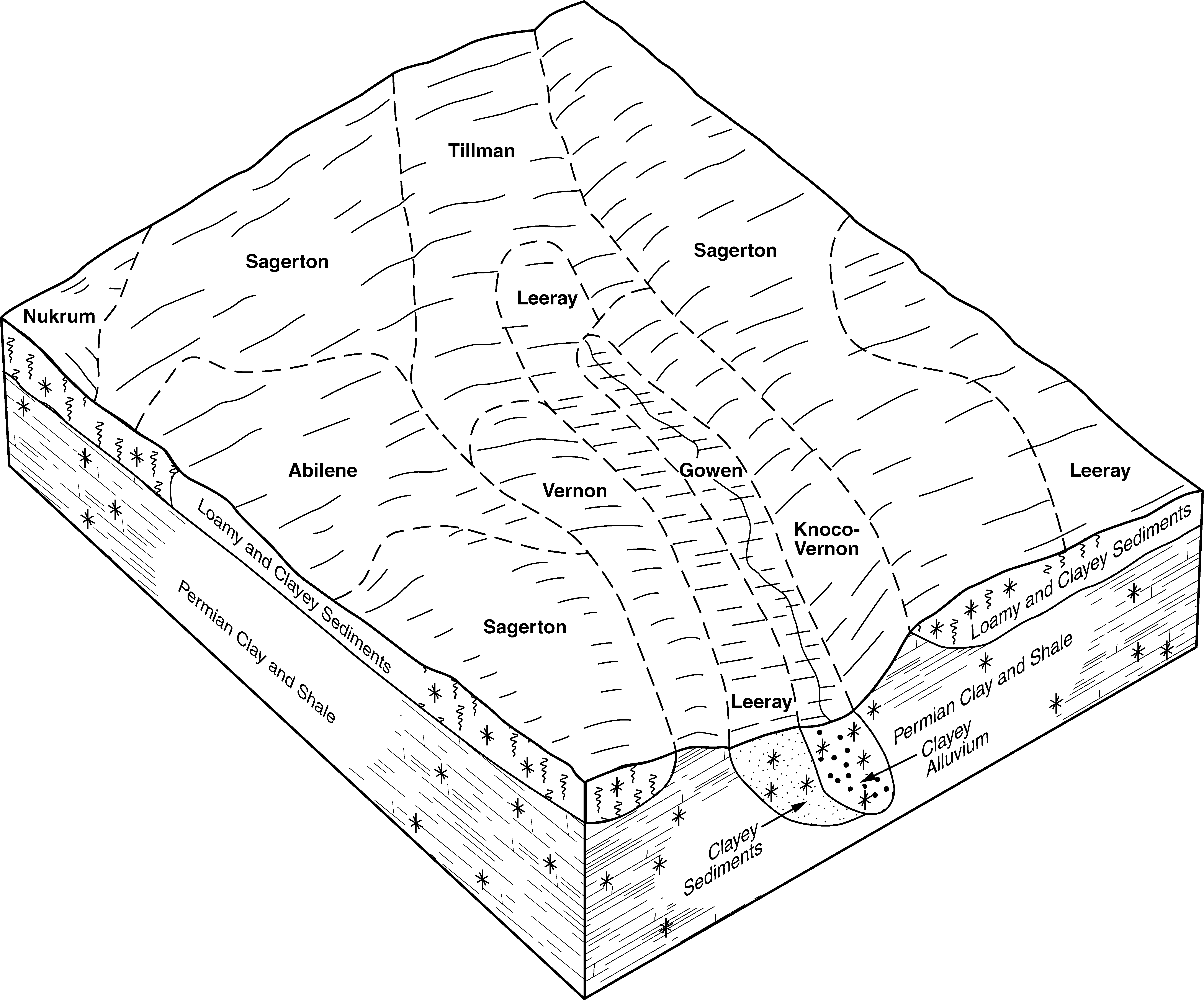
| Abilene silt loam, 0 to 1 percent slopes | 5401 | 209 | 1381694 | 2t6p1 | ks025 | 1980 | 1:24000 |
Abilene silt loam, 1 to 3 percent slopes | 5403 | 118 | 1381695 | 2t6p2 | ks025 | 1980 | 1:24000 |
Abilene silt loam, 1 to 3 percent slopes | 5403 | 14863 | 1381235 | 2t6p2 | ks033 | 1987 | 1:24000 |
Abilene silt loam, 0 to 1 percent slopes | 5401 | 3292 | 1381234 | 2t6p1 | ks033 | 1987 | 1:24000 |
Abilene silt loam, 1 to 3 percent slopes | 5403 | 1422 | 1380483 | 2t6p2 | ks097 | 1983 | 1:24000 |
Abilene clay loam, 0 to 1 percent slopes | 1 | 2905 | 381644 | 2vt80 | ok009 | 1978 | 1:24000 |
Abilene silt loam, 1 to 3 percent slopes | AbsB | 568 | 383061 | 2t6p2 | ok059 | 1998 | 1:24000 |
Abilene loam, 0 to 1 percent slopes | Ab | 14096 | 384933 | 2vt82 | ok141 | 1968 | 1:24000 |
Abilene silt loam, 0 to 1 percent slopes | 1 | 1619 | 384992 | 2t6p1 | ok149 | 1976 | 1:24000 |
Abilene silt loam, 1 to 3 percent slopes, eroded | AbsB2 | 466 | 385156 | dxsd | ok151 | 1995 | 1:24000 |
Abilene clay loam, dry, 0 to 1 percent slopes | AbA | 9866 | 362463 | 2vwyz | tx011 | 1963 | 1:20000 |
Abilene clay loam, dry, 1 to 3 percent slopes | AbB | 704 | 362464 | 2vwz1 | tx011 | 1963 | 1:20000 |
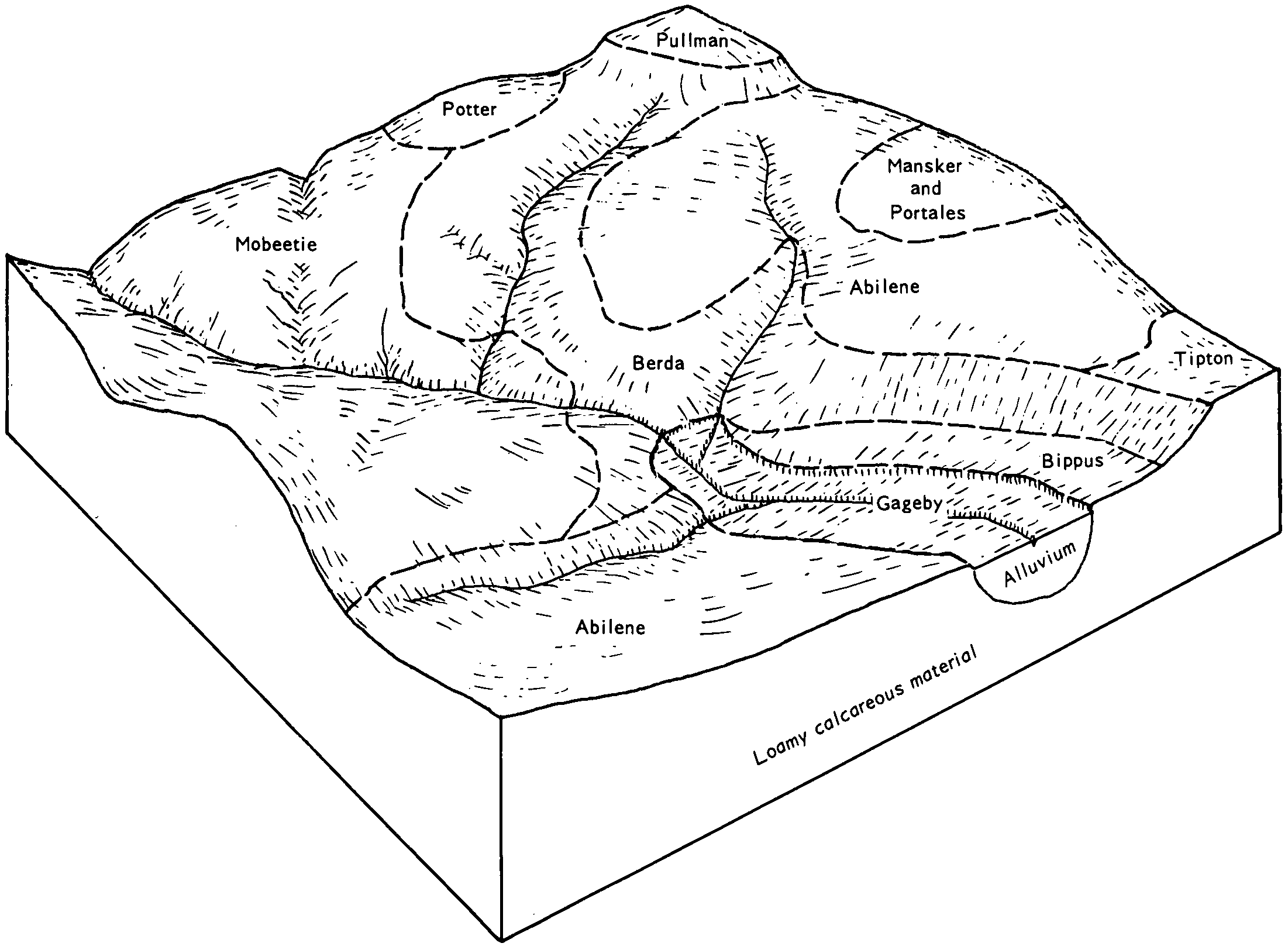
Abilene loam, 0 to 1 percent slopes | 1 | 5961 | 363582 | 2vt82 | tx059 | 1979 | 1:24000 |
Abilene loam, 1 to 3 percent slopes | 2 | 4766 | 363593 | 2vt83 | tx059 | 1979 | 1:24000 |
Abilene clay loam, dry, 0 to 1 percent slopes | AbA | 7026 | 363807 | 2vwyz | tx075 | 1961 | 1:20000 |
Abilene clay loam, dry, 1 to 3 percent slopes | AbB | 2285 | 363808 | 2vwz1 | tx075 | 1961 | 1:20000 |
Abilene-Childress complex, 0 to 1 percent slopes | AcA | 967 | 363809 | 2y7bl | tx075 | 1961 | 1:20000 |
Abilene-Childress complex, 1 to 3 percent slopes | AcB | 562 | 363810 | 2y7bm | tx075 | 1961 | 1:20000 |
Abilene clay loam, moist, 0 to 1 percent slopes | AbA | 5561 | 364000 | 2vwyy | tx083 | 1968 | 1:24000 |
Abilene clay loam, moist, 1 to 3 percent slopes | AbB | 2556 | 364001 | 2vwz0 | tx083 | 1968 | 1:24000 |
Abilene clay loam, dry, 0 to 1 percent slopes | AbA | 1692 | 364092 | 2vwyz | tx087 | 1965 | 1:20000 |
Abilene clay loam, dry, 1 to 3 percent slopes | AbB | 1319 | 364093 | 2vwz1 | tx087 | 1965 | 1:20000 |
Abilene clay loam, dry, 0 to 1 percent slopes | AbA | 932 | 364573 | 2vwyz | tx101 | 1969 | 1:20000 |
Abilene clay loam, dry, 1 to 3 percent slopes | AbB | 6448 | 364695 | 2vwz1 | tx107 | 1964 | 1:20000 |
Abilene clay loam, dry, 0 to 1 percent slopes | AbA | 3719 | 364694 | 2vwyz | tx107 | 1964 | 1:20000 |
Abilene clay loam, dry, 0 to 1 percent slopes | AbA | 15645 | 365107 | 2vwyz | tx125 | 1965 | 1:20000 |
Abilene clay loam, dry, 0 to 1 percent slopes | AbA | 6821 | 378317 | 2vwyz | tx169 | 1965 | 1:24000 |
Abilene clay loam, dry, 0 to 1 percent slopes | AbA | 5710 | 366922 | 2vwyz | tx191 | 1965 | 1:20000 |
Abilene clay loam, dry, 1 to 3 percent slopes | AbB | 412 | 366923 | 2vwz1 | tx191 | 1965 | 1:20000 |
Abilene clay loam, 1 to 3 percent slopes | AbB | 1513 | 367116 | 2vt81 | tx197 | 1965 | 1:20000 |
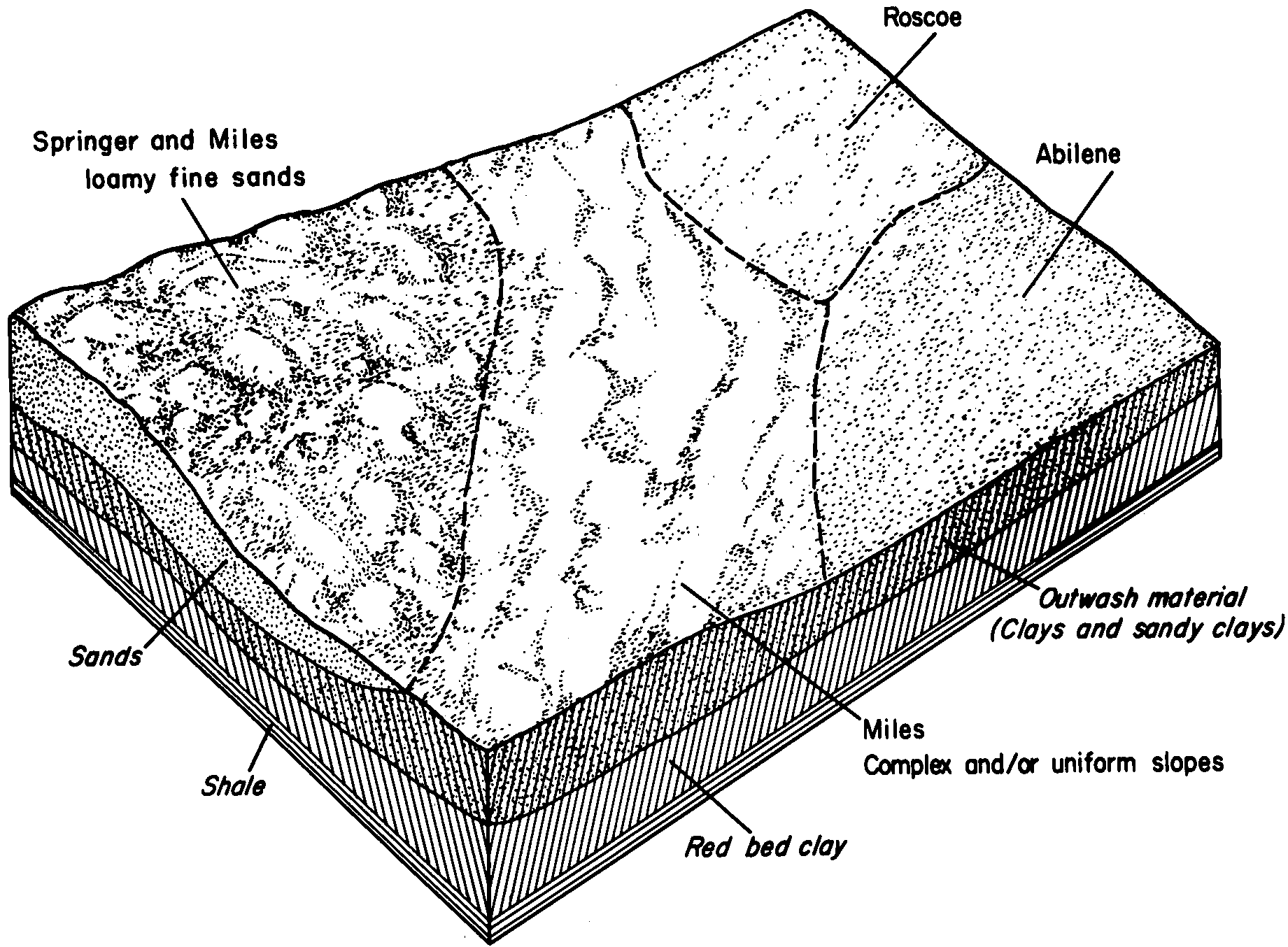
Abilene-Miles complex, 0 to 2 percent slopes | Ae | 26415 | 367476 | 2y7bp | tx207 | 1960 | 1:20000 |
Abilene clay loam, 1 to 3 percent slopes | AcB | 11799 | 367472 | 2vt81 | tx207 | 1960 | 1:20000 |
Abilene loam, 0 to 1 percent slopes | AdA | 11731 | 367474 | 2vt82 | tx207 | 1960 | 1:20000 |
Abilene clay loam, 1 to 3 percent slopes, eroded | AcB2 | 2532 | 367473 | 2y7bn | tx207 | 1960 | 1:20000 |
Abilene loam, 1 to 3 percent slopes | AdB | 271 | 367475 | 2vt83 | tx207 | 1960 | 1:20000 |
Abilene clay loam, 1 to 3 percent slopes | AbB | 2444 | 368224 | 2vt81 | tx253 | 1966 | 1:20000 |
Abilene clay loam, dry, 0 to 1 percent slopes | AbA | 10342 | 368469 | 2vwyz | tx263 | 1968 | 1:31680 |
Abilene clay loam, dry, 0 to 1 percent slopes | AbA | 6635 | 370846 | 2vwyz | tx345 | 1972 | 1:24000 |
Abilene clay loam, dry, 1 to 3 percent slopes | AbB | 1755 | 370847 | 2vwz1 | tx345 | 1972 | 1:24000 |
Abilene clay loam, moist, 0 to 1 percent slopes | AbA | 400 | 372047 | 2vwyy | tx417 | 1985 | 1:24000 |
Abilene clay loam, moist, 0 to 1 percent slopes | AbA | 1598 | 372678 | 2vwyy | tx447 | 1991 | 1:24000 |
Abilene loam, 0 to 1 percent slopes | AbA | 2714 | 373789 | 2vt82 | tx503 | 2003 | 1:24000 |
Abilene clay loam, moist, 1 to 3 percent slopes | 2 | 9424 | 390993 | 2vwz0 | tx602 | 1975 | 1:24000 |
Abilene clay loam, moist, 0 to 1 percent slopes | 1 | 4765 | 390982 | 2vwyy | tx602 | 1975 | 1:24000 |
Abilene-Urban land complex, 0 to 2 percent slopes | 3 | 835 | 391004 | f3w1 | tx602 | 1975 | 1:24000 |
