| Aaron silt loam, 2 to 6 percent slopes | AaB | 1291 | 550272 | lglq | ky135 | 1998 | 1:20000 |
Aaron silt loam, 6 to 12 percent slopes | AaC | 1333 | 550506 | lgv8 | ky173 | 1983 | 1:20000 |
Aaron silt loam, 2 to 6 percent slopes | AaB | 317 | 550505 | lgv7 | ky173 | 1983 | 1:20000 |
Aaron silt loam, 1 to 5 percent slopes | 73471 | 2072 | 901243 | 2t7fl | mo093 | 1988 | 1:24000 |
Gatewood-Aaron complex, 8 to 15 percent slopes, severely eroded | 73291 | 8 | 2502321 | 2vxrw | mo093 | 1988 | 1:24000 |
Gatewood-Aaron complex, 8 to 15 percent slopes, severely eroded | 73291 | 774 | 2502322 | 2vxrw | mo179 | 2004 | 1:24000 |
Gatewood-Aaron complex, 3 to 8 percent slopes | 73290 | 88 | 2502318 | 2vxrv | mo179 | 2004 | 1:24000 |
Gatewood-Aaron complex, 8 to 15 percent slopes, severely eroded | 73291 | 185 | 2502323 | 2vxrw | mo187 | 1979 | 1:24000 |
Gatewood-Aaron complex, 3 to 8 percent slopes | 73290 | 32 | 2502319 | 2vxrv | mo187 | 1979 | 1:24000 |
Gatewood-Aaron complex, 8 to 15 percent slopes, severely eroded | 73291 | 5280 | 2502324 | 2vxrw | mo221 | 2003 | 1:24000 |
Gatewood-Aaron complex, 3 to 8 percent slopes | 73290 | 2641 | 2502320 | 2vxrv | mo221 | 2003 | 1:24000 |
Aaron silt loam, 2 to 6 percent slopes | AaB | 3227 | 170071 | 5pz5 | oh001 | 1987 | 1:15840 |
Aaron silt loam, 0 to 2 percent slopes | AaA | 1666 | 170070 | 5pz4 | oh001 | 1987 | 1:15840 |
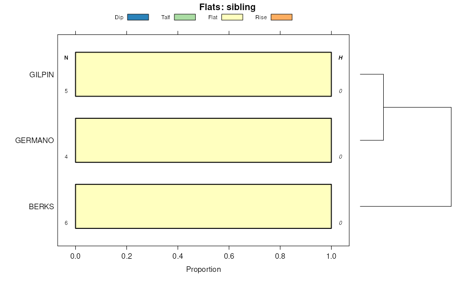
Gilpin-Aaron complex, 6 to 15 percent slopes | GpC | 274 | 1008312 | 12v76 | oh009 | 1981 | 1:15840 |
Aaron-Gilpin complex, 8 to 15 percent slopes | AgC | 194 | 1008368 | 12v90 | oh009 | 1981 | 1:15840 |
Aaron silt loam, 6 to 15 percent slopes | AbC | 61 | 1008307 | 2z392 | oh009 | 1981 | 1:15840 |
Aaron-Gilpin complex, 6 to 12 percent slopes, eroded | AdC2 | 30 | 1008407 | 12vb8 | oh009 | 1981 | 1:15840 |
Aaron silt loam, 6 to 12 percent slopes, eroded | AaC2 | 10 | 1008406 | 2z394 | oh009 | 1981 | 1:15840 |
Aaron silt loam, 2 to 6 percent slopes | AaB | 2 | 1710444 | 2z390 | oh013 | 1978 | 1:15840 |
Aaron silty clay loam, 6 to 15 percent slopes, eroded | AoC2 | 7 | 1670011 | 1t1sb | oh019 | 1981 | 1:15840 |
Aaron silt loam, 6 to 15 percent slopes, eroded | AaC2 | 8519 | 536591 | 2z39d | oh031 | 1996 | 1:15840 |
Aaron silt loam, 2 to 6 percent slopes | AaB | 1419 | 536590 | 2z390 | oh031 | 1996 | 1:15840 |
Aaron silt loam, 8 to 15 percent slopes | AbC | 10 | 2108970 | 2z393 | oh031 | 1996 | 1:15840 |
Aaron silt loam, 8 to 15 percent slopes, eroded | AbC2 | 4 | 2108955 | 2z395 | oh031 | 1996 | 1:15840 |
Aaron silt loam, 2 to 8 percent slopes | AbB | 1 | 2108954 | 2z391 | oh031 | 1996 | 1:15840 |
Aaron silt loam, 8 to 15 percent slopes | AaC | 605 | 536787 | 2z393 | oh053 | 1988 | 1:15840 |
Aaron-Gilpin complex, 8 to 15 percent slopes | AbC | 32 | 1460307 | 1l0kp | oh053 | 1988 | 1:15840 |
Aaron-Upshur complex, 8 to 15 percent slopes, eroded | AbC2 | 6509 | 536862 | l0n4 | oh059 | 1998 | 1:15840 |
Aaron silt loam, 8 to 15 percent slopes | AaC | 4715 | 536860 | 2z393 | oh059 | 1998 | 1:15840 |
Aaron silt loam, 2 to 8 percent slopes | AaB | 2242 | 536859 | 2z391 | oh059 | 1998 | 1:15840 |
Aaron-Upshur complex, 2 to 8 percent slopes | AbB | 2044 | 536861 | l0n3 | oh059 | 1998 | 1:15840 |
Aaron silt loam, 8 to 15 percent slopes, eroded | AaC2 | 293 | 1592904 | 2z395 | oh059 | 1998 | 1:15840 |
Aaron silty clay loam, 6 to 15 percent slopes, eroded | AbC2 | 6775 | 536711 | l0h8 | oh067 | 1993 | 1:15840 |
Aaron silt loam, 2 to 6 percent slopes | AaB | 861 | 536710 | 2z390 | oh067 | 1993 | 1:15840 |
Berks-Aaron complex, 6 to 15 percent slopes | BmC | 495 | 536716 | l0hf | oh067 | 1993 | 1:15840 |
Aaron silt loam, 8 to 15 percent slopes | AcC | 52 | 1695488 | 2z393 | oh067 | 1993 | 1:15840 |
Aaron silt loam, 6 to 15 percent slopes | AaC | 5 | 1398169 | 2z392 | oh073 | 1986 | 1:15840 |
Aaron silty clay loam, 6 to 15 percent slopes, eroded | AoC2 | 5 | 1652922 | 1sh02 | oh081 | 1987 | 1:15840 |
Berks-Aaron complex, 6 to 15 percent slopes | BlC | 5 | 1652923 | 1sh03 | oh081 | 1987 | 1:15840 |
Aaron silt loam, 2 to 8 percent slopes | AaB | 28 | 1540758 | 2z391 | oh089 | 1986 | 1:15840 |
Aaron silt loam, 8 to 15 percent slopes, eroded | AaC2 | 5 | 1540759 | 2z395 | oh089 | 1986 | 1:15840 |
Aaron-Gilpin complex, 8 to 15 percent slopes | AgC | 2442 | 537139 | l0y2 | oh105 | 1991 | 1:15840 |
Aaron-Upshur complex, 8 to 15 percent slopes, eroded | AuC2 | 1490 | 537140 | l0y3 | oh105 | 1991 | 1:15840 |
Aaron silt loam, 6 to 12 percent slopes, eroded | AaC2 | 965 | 537418 | 2z394 | oh115 | 1992 | 1:15840 |
Aaron-Gilpin complex, 6 to 12 percent slopes, eroded | AgC2 | 30 | 537419 | l173 | oh115 | 1992 | 1:15840 |
Aaron silt loam, 8 to 15 percent slopes, eroded | AaC2 | 9553 | 537850 | 2z395 | oh119 | 1989 | 1:15840 |
Aaron silt loam, 15 to 25 percent slopes, eroded | AaD2 | 2747 | 537851 | 2z39f | oh119 | 1989 | 1:15840 |
Aaron silt loam, 2 to 8 percent slopes | AaB | 1215 | 537849 | 2z391 | oh119 | 1989 | 1:15840 |
Aaron-Upshur complex, 2 to 6 percent slopes | AcB | 463 | 537852 | l1p2 | oh119 | 1989 | 1:15840 |
Aaron silt loam, 6 to 12 percent slopes, eroded | AaC2 | 31 | 1481785 | 2z394 | oh121 | 1986 | 1:15840 |
Aaron silt loam, 8 to 15 percent slopes | AaC | 240 | 1589368 | 2z393 | oh157 | 1981 | 1:15840 |
Aaron silty clay loam, 6 to 15 percent slopes, eroded | AnC2 | 153 | 1589381 | 1qbwc | oh157 | 1981 | 1:15840 |
Aaron silt loam, 2 to 8 percent slopes | AaB | 43 | 1589367 | 2z391 | oh157 | 1981 | 1:15840 |
Aaron silt loam, 2 to 6 percent slopes | AbB | 8 | 1589380 | 2z390 | oh157 | 1981 | 1:15840 |
Gilpin-Aaron complex, 6 to 15 percent slopes | GcC | 3228 | 536385 | l04r | oh163 | 1998 | 1:15840 |
Aaron silt loam, 6 to 15 percent slopes | AbC | 5 | 536353 | 2z392 | oh163 | 1998 | 1:15840 |

