Newlancreek-Sixteenmile-Absarook complex, 2 to 8 percent slopes
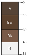
Newlancreek
(50%)
Shallow Alpine Group
Lithic Haplustolls
Well drained
Hydric: No
PAWS: 7 cm
low hills
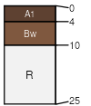
Sixteenmile
(30%)
Shallow Grassland Group
Lithic Ustorthents
Well drained
Hydric: No
PAWS: 1 cm
low hills
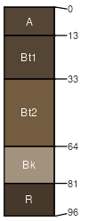
Absarook
(20%)
Upland Sagebrush Shrubland Group
Typic Argiustolls
Well drained
Hydric: No
PAWS: 14 cm
low hills
SSA
Scale
Published
Export
mt637
1:24,000
2014
2025-08-31