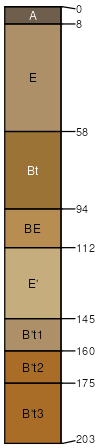
Candor sand, 0 to 6 percent slopes
Candor
(85%)
Dry Sandy Upland Woodland
Arenic Paleudults
Somewhat excessively drained
Hydric: No
PAWS: 12 cm
hills / Shoulder
hills / Summit
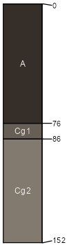
Johnston
(2%)
Flood Plains And Seepage Swamps
Cumulic Humaquepts
Very poorly drained
Hydric: Yes
PAWS: 17 cm
drainageways
flood plains
SSA
Scale
Published
Export
sc031
1:24,000
1998
2025-09-02