Blackcreek-McGregor-Tallcreek complex, 0 to 8 percent slopes
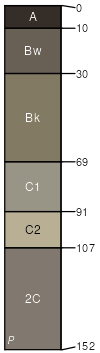
Blackcreek
(45%)
Bottomland Group
Typic Endoaquepts
Poorly drained
Hydric: Yes
PAWS: 23 cm
flood plains
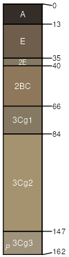
McGregor
(35%)
Subirrigated Grassland Group
Aquandic Fluvaquents
Poorly drained
Hydric: Yes
PAWS: 26 cm
flood plains
Tallcreek
(20%)
Upland Cool Moist Woodland Group
Vitrandic Eutrudepts
Moderately well drained
Hydric: No
PAWS: 28 cm
stream terraces
SSA
Scale
Published
Export
mt618
1:24,000
2008
2025-08-30