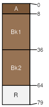
Bankston extremely channery loam, 8 to 15 percent slopes
Bankston
(90%)
Limestone Hill, Desert Foothills
Ustic Haplocalcids
Well drained
Hydric: No
PAWS: 5 cm
hillslopes / Shoulder
hillslopes / Backslope
hillslopes / Footslope
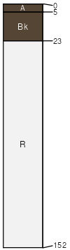
Bissett
(5%)
Limestone Hill and Mountain, Desert Grassland
Hydric: No
PAWS: NA
hills / Shoulder
hills / Backslope
hills / Footslope
hills / Toeslope
Crossen
(3%)
Gravelly, Desert Shrub
Hydric: No
PAWS: NA
fan remnants
Rock outcrop
(2%)
Hydric: No
PAWS: NA
hills / Shoulder
hills / Backslope
hills / Footslope
hills / Toeslope
SSA
Scale
Published
Export
nm719
1:24,000
2000
2025-09-09