Guernsey-Westmore silt loams, 18 to 35 percent slopes, severely eroded
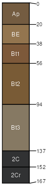
Guernsey
(65%)
Side Slope
Aquic Hapludalfs
Moderately well drained
Hydric: No
PAWS: 21 cm
hills / Backslope
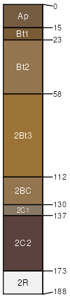
Westmore
(25%)
Side Slope
Typic Hapludalfs
Well drained
Hydric: No
PAWS: 22 cm
hills / Backslope
many small limestone fragments in the surface layer
(5%)
Hydric:
PAWS: NA
gullied areas
(5%)
Hydric:
PAWS: NA
SSA
Scale
Published
Export
oh111
1:16,000
1968
2025-09-02