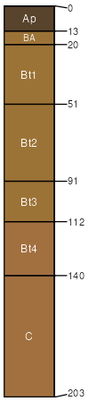
Richland silt loam, 1 to 7 percent slopes
less clay and more sand and rock fragments in the subsoil
(%)
Hydric:
PAWS: NA
clay loam surface layer
(%)
Hydric:
PAWS: NA
silty clay loam surface layer
(%)
Hydric:
PAWS: NA
Richland
(85%)
Footslope
Typic Hapludalfs
Well drained
Hydric: No
PAWS: 19 cm
hills / Footslope
poorly drained soils
(5%)
Hydric: Yes
PAWS: NA
drainageways
Tioga
(4%)
Hydric:
PAWS: NA
flood plains
Orrville
(3%)
Hydric:
PAWS: NA
flood plains
Fitchville Variant
(3%)
Hydric:
PAWS: NA
terraces
SSA
Scale
Published
Export
oh081
1:16,000
1987
2025-09-02