Bland-Rock outcrop complex, 15 to 25 percent slopes
Bland
(80%)
Mesic Limestone And Dolomite Uplands
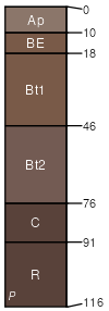
Typic Hapludalfs
Well drained
Hydric: No
PAWS: 12 cm
hills / Backslope
hills / Shoulder
hills / Summit
spurs / Footslope
Rock outcrop
(15%)
Hydric: No
PAWS: NA
hills / Backslope
hills / Shoulder
hills / Summit
spurs / Footslope
escarpments / Summit
escarpments / Shoulder
escarpments / Backslope
SSA
Scale
Published
Export
va185
1:24,000
1996
2025-09-08