Rencot-Rock outcrop complex, 5 to 15 percent slopes
Rencot
(65%)
Very Shallow High Plains Southeast (VS)
Lithic Calciustepts
Well drained
Hydric: No
PAWS: 4 cm
hills / Summit
Rock outcrop
(20%)
Hydric: No
PAWS: NA
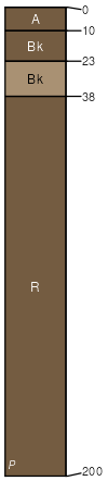
Fiveoh
(10%)
Sandy High Plains Southeast (Sy)
Ustic Haplocalcids
Well drained
Hydric: No
PAWS: 22 cm
stream terraces
Rock River
(3%)
Sandy High Plains Southeast (Sy)
Ustic Calciargids
Well drained
Hydric: No
PAWS: 26 cm
fans
Thermopolis
(2%)
Shallow Loamy High Plains Southeast (SwLy)
Ustic Torriorthents
Well drained
Hydric: No
PAWS: 6 cm
hills
SSA
Scale
Published
Export
wy625
1:24,000
1985
2025-09-04