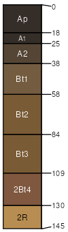
Ashdale silt loam, 2 to 6 percent slopes, moderately eroded
Ashdale
(90%)
Mollic Loamy-Silty Upland
Typic Argiudolls
Well drained
Hydric: No
PAWS: 23 cm
ridges / Summit
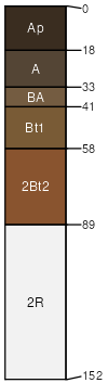
Tama
(7%)
Mollic Loamy-Silty Upland
Typic Argiudolls
Well drained
Hydric: No
PAWS: 32 cm
ridges / Summit
Dodgeville
(3%)
Mollic Loamy-Silty Upland
Typic Argiudolls
Well drained
Hydric: No
PAWS: 15 cm
ridges / Summit
SSA
Scale
Published
Export
wi045
1:12,000
1969
2025-09-10