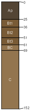
Griswold silt loam, 6 to 12 percent slopes, eroded
Griswold
(92%)
Loamy and Clayey Upland
Typic Argiudolls
Well drained
Hydric: No
PAWS: 27 cm
till plains / Summit
till plains / Backslope
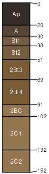
Rotamer
(5%)
Loamy Upland with Carbonates
Typic Argiudolls
Well drained
Hydric: No
PAWS: NA
till plains / Summit
till plains / Backslope
Ringwood
(3%)
Loamy and Clayey Upland
Typic Argiudolls
Well drained
Hydric: No
PAWS: NA
till plains / Summit
till plains / Backslope
SSA
Scale
Published
Export
wi047
1:20,000
1974
2025-09-10