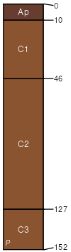
Clairemont silty clay loam, 0 to 1 percent slopes, channeled, frequently flooded
Clairemont
(90%)
Loamy Bottomland 19-26 PZ
Typic Ustifluvents
Well drained
Hydric: No
PAWS: 41 cm
flood plains
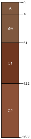
Mangum
(5%)
Clayey Bottomland 23-30 PZ
Vertic Haplustepts
Well drained
Hydric: No
PAWS: NA
flood plains / Toeslope
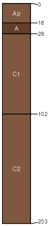
Port
(3%)
Loamy Bottomland
Cumulic Haplustolls
Well drained
Hydric: No
PAWS: NA
flood plains / Toeslope
Westola
(2%)
Loamy Bottomland 19-26 PZ
Typic Ustifluvents
Well drained
Hydric: No
PAWS: NA
flood plains
river valleys
SSA
Scale
Published
Export
ok141
1:24,000
1968
2025-08-29