Nankin-Conecuh complex, 15 to 45 percent slopes
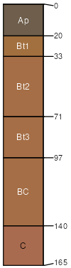
Nankin
(50%)
Typic Kanhapludults
Well drained
Hydric: No
PAWS: 21 cm
hills / Shoulder
Conecuh
(30%)
Vertic Hapludults
Moderately well drained
Hydric: No
PAWS: 22 cm
hills / Summit
Muckalee
(6%)
Typic Fluvaquents
Poorly drained
Hydric: Yes
PAWS: 18 cm
depressions / Toeslope
SSA
Scale
Published
Export
al067
1:20,000
1986
2025-09-09