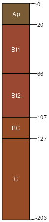
Cecil sandy clay loam, 6 to 10 percent slopes, moderately eroded
Cecil
(90%)
Acidic upland forest, moist
Typic Kanhapludults
Well drained
Hydric: No
PAWS: 27 cm
interfluves / Summit
interfluves / Shoulder
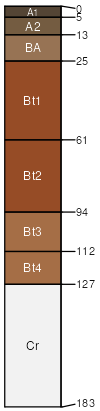
Spartanburg
(1%)
Typic Kanhapludults
Well drained
Hydric: No
PAWS: 16 cm
hillslopes
ridges / Backslope
SSA
Scale
Published
Export
nc081
1:20,000
1975
2025-09-02