Carbonates at 10 to 18 inches (%)
Hydric:
PAWS: NA |

|
|
Areas that are severely eroded (%)
Hydric:
PAWS: NA |
|
|
|
Clay loam surface layer (%)
Hydric:
PAWS: NA |
|
|
|
Darker colored surface layer (%)
Hydric:
PAWS: NA |
|
|
|
Less clay in the subsoil (%)
Hydric:
PAWS: NA |
|
|
|
Bedrock at 48 to 60 inches (%)
Hydric:
PAWS: NA |
|
|
|
St. Clair (%)
Hydric:
PAWS: NA |
|
|
Sandy loam, silt loam, or fine sandy loam surface layer (%)
Hydric:
PAWS: NA |
|
|
|
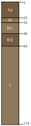
Nappanee (90%)
Lake Plain Flats
Aeric Epiaqualfs
Somewhat poorly drained
Hydric: No
PAWS: 16 cm |
knolls lake plains / Summit lake plains / Shoulder lake plains / Backslope
|
|
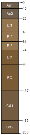
Well drained (10%)
Hydric:
PAWS: NA |
knolls lake plains / Summit lake plains / Shoulder
|
|