Teton-Cheadle loams, 8 to 15 percent slopes
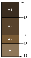
Teton
(50%)
Upland Shrubland Group
Ustic Haplocryolls
Well drained
Hydric: No
PAWS: 11 cm
high hills / Footslope
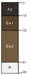
Cheadle
(38%)
Shallow Shrubland Group
Lithic Haplocryolls
Well drained
Hydric: No
PAWS: 5 cm
high hills / Summit
high hills / Shoulder
Cheadle
(12%)
Shallow Shrubland Group
Lithic Haplocryolls
Well drained
Hydric: No
PAWS: 5 cm
high hills / Summit
high hills / Shoulder
SSA
Scale
Published
Export
mt666
1:24,000
2008
2023-08-30