Rock outcrop-Devilfence association, 2 to 25 percent slopes
Rock outcrop
(45%)
Hydric: Unranked
PAWS: NA
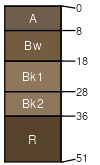
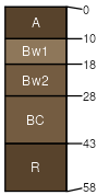
Devilfence
(30%)
Shallow Sagebrush Shrubland Group
Lithic Haplustepts
Somewhat excessively drained
Hydric: No
PAWS: 3 cm
hillsides
escarpments
ridges
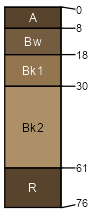
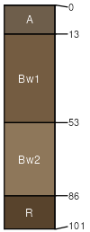
Wilspring
(6%)
Upland Sagebrush Shrubland Group
Typic Haplustepts
Well drained
Hydric: No
PAWS: 5 cm
ridges
hillsides
escarpments
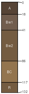
Vigilante
(5%)
Upland Sagebrush Shrubland Group
Typic Haplustolls
Well drained
Hydric: No
PAWS: 10 cm
escarpments
hillsides
alluvial fans
interfluves
ridges
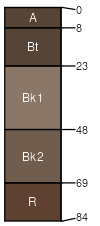
Quincreek
(5%)
Upland Shrubland Group
Typic Argiustolls
Well drained
Hydric: No
PAWS: 7 cm
knolls
hillsides
alluvial fans
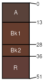
Deville
(3%)
Shallow Shrubland Group
Lithic Haplustepts
Somewhat excessively drained
Hydric: No
PAWS: 4 cm
ridges
hillsides
escarpments
Quaint
(3%)
Shallow Shrubland Group
Lithic Haplustepts
Somewhat excessively drained
Hydric: No
PAWS: 4 cm
plateaus
hillsides
ridges
Wilde
(3%)
Upland Sagebrush Shrubland Group
Typic Haplustepts
Well drained
Hydric: No
PAWS: 6 cm
ridges
hillsides
escarpments
SSA
Scale
Published
Export
mt627
1:24,000
1998
2025-08-31