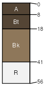
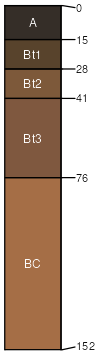
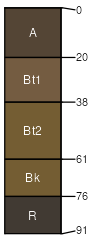
Tolbert, very stony-Rock outcrop-Blaincreek, very stony, complex, 35 to 60 percent slopes

Tolbert (40%)
Shallow Sagebrush Shrubland Group
Lithic Argiustolls
Well drained
Hydric: No
PAWS: 3 cm
ridges
interfluves
hillsides
escarpments
Rock outcrop (20%)


Hydric: Unranked
PAWS: NA
Blaincreek (15%)
Upland Sagebrush Shrubland Group
Typic Argiustolls
Well drained
Hydric: No
PAWS: 7 cm
ridges
escarpments
hillsides
Sawicki (7%)
Upland Sagebrush Shrubland Group
Typic Argiustolls
Well drained
Hydric: No
PAWS: 14 cm
alluvial fans
mountain slopes
escarpments
hillsides
Perma (6%)
Upland Sagebrush Shrubland Group
Typic Haplustolls
Somewhat excessively drained
Hydric: No
PAWS: 11 cm
ridges
escarpments
hillsides
alluvial fans
Brickner (5%)
Lithic Haplustalfs
Well drained
Hydric: No
PAWS: 3 cm
ridges
hillsides
escarpments
Gnojek (3%)
Lithic Argiustolls
Well drained
Hydric: No
PAWS: 3 cm
escarpments
hillsides
ridges
Libeg (2%)
Upland Shrubland Group
Ustic Argicryolls
Well drained
Hydric: No
PAWS: 11 cm
alluvial fans
mountain slopes
mountain valleys
outwash terraces
Wickes (2%)
Upland Sagebrush Shrubland Group
Typic Argiustolls
Well drained
Hydric: No
PAWS: 8 cm
ridges
interfluves
hillsides
escarpments
SSAScalePublishedExport
mt6271:24,00019982023-08-28